The UK is bracing for widespread snow and ice as the Met Office issues warnings, cautioning that the wintry conditions "could create some particularly tricky travel conditions."
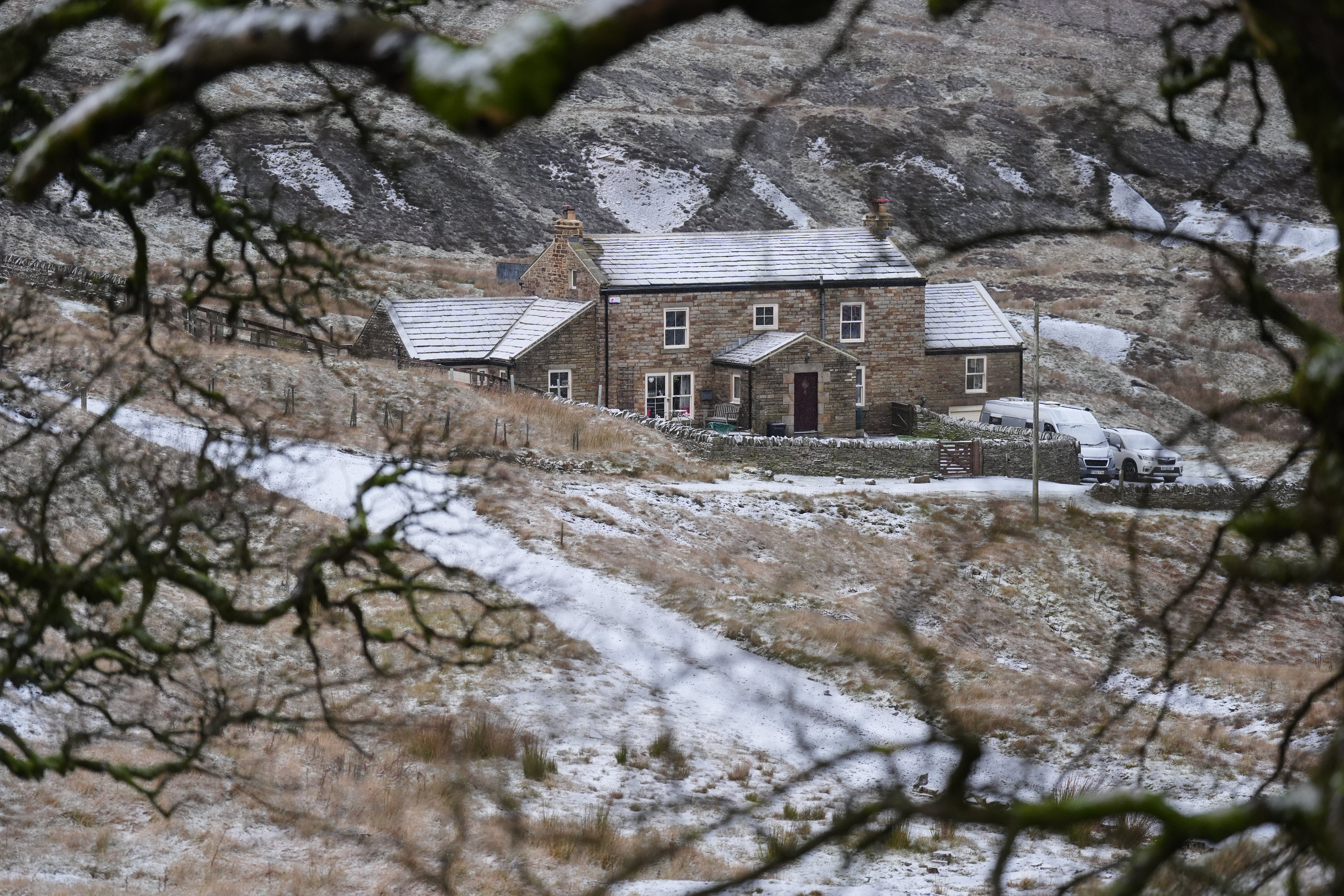
This comes as a cold snap tightens its grip across the northern half of the country, with snow already having fallen in parts of Scotland.
A yellow warning for snow and ice is now active across Northern Ireland, running from midnight until midday on Wednesday.
Further north, much of Scotland faces a similar alert from 6pm on Tuesday through to 9pm on Thursday. Meanwhile, large swathes of north-east England and Yorkshire will be under a yellow warning from Wednesday at 12am until 11.59pm on Thursday.
The Met Office anticipates that rain and hill snow, followed by clearing skies, will lead to a risk of icy patches developing overnight from Tuesday into Wednesday morning.
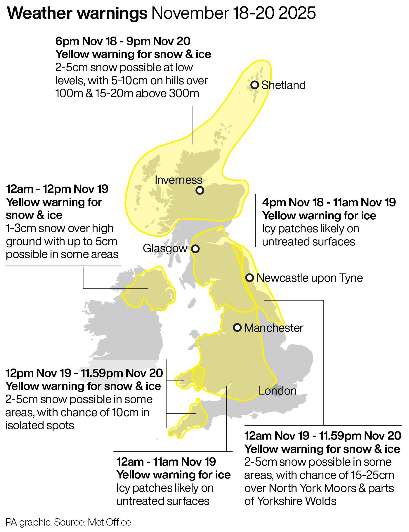
A yellow warning for ice is in place across much of Wales, northern and central England and southern Scotland until 11am on Wednesday.
The Met Office has also issued an amber weather warning for snow in parts of Yorkshire on Thursday between 5am and 9pm, as it said power cuts and travel delays on roads were likely in the “first notable cold snap of this autumn”.
Frequent wintry showers will feed inland from the North Sea, giving significant snow accumulations over the North York Moors and parts of the Yorkshire Wolds.
By the end of Thursday, as much as 15-25cm may have accumulated on hills above 100m elevation, which is likely to cause “substantial disruption”, the Met Office said.
It added that power cuts and travel delays on roads were likely, possibly stranding some vehicles and passengers.
Snow & ice warnings come into force overnight ⚠️
— Met Office (@metoffice) November 18, 2025
Take extra care on the roads during icy weather and stay up to date with the warnings 👉 https://t.co/QwDLMfRBfs pic.twitter.com/hZEzIAijVh
Met Office chief forecaster Neil Armstrong said: “Cold Arctic air from the north is firmly in charge of the UK’s weather, bringing the first notable cold snap of this autumn and giving an early taste of winter weather.
“As a result, winter hazards are likely through the next few days, with snow and ice a particular hazard, and the coldest conditions likely on Wednesday and Thursday.
“Wintry showers will affect areas exposed to the brisk northerly wind, in particular Northern Ireland, south-west Wales, south-west England, north-east England and across the northern half of Scotland.
“Whilst not all places will see lying snow, where showers are most frequent accumulations of 2-5cm will be possible. On higher ground in Scotland 15-20cm could accumulate and potentially as much as 15-25cm over the North York Moors and Yorkshire Wolds.”
A yellow weather warning has also been issued for snow and ice across parts of south-west Wales and south-western England from midday on Wednesday to 11.59pm on Thursday.
❄️Driving in icy, wintry weather? Stay safe! ❄️
— National Highways: Yorkshire (@HighwaysYORKS) November 18, 2025
✅ Check weather & plan your route
✅ Slow down – stopping takes 10x longer
✅ Leave extra space & watch for hidden road markings
Full advice here: https://t.co/LXmFYRzNuM
Stay safe out there! 🚗✨#WeatherReady #TRIP pic.twitter.com/ksbZ89d5AL
In addition to snow, ice will be an ongoing hazard, particularly overnight in the coming days.
Things will be drier for many by Friday, with temperatures gradually turning milder and rain reaching the west later in the day.
Mr Armstrong said: “Temperatures are well below average for the time of year and could get as low as -11C in rural parts of Scotland on Thursday night, with daytime temperatures generally in low single figures for many. With clear skies, overnight ice could create some particularly tricky travel conditions.”
Darren Clark, severe weather resilience adviser at National Highways said: “With snow forecast and freezing conditions across parts of England this week, National Highways winter operation is in full swing with gritters already completing their first runs of the season.
“We have more than 530 gritters available nationally and we can rapidly call on additional reserves when snow hits or conditions demand it. We work closely with the Met Office, receiving updated forecasts throughout the day and our crews are on duty around the clock, ready to head out whenever they’re needed.
“We’re also urging drivers to prepare for winter, and not be caught out by it. Quick checks, such as topping up fuel and screenwash, checking lights and tyres, and planning ahead, can make all the difference when the weather turns.”