
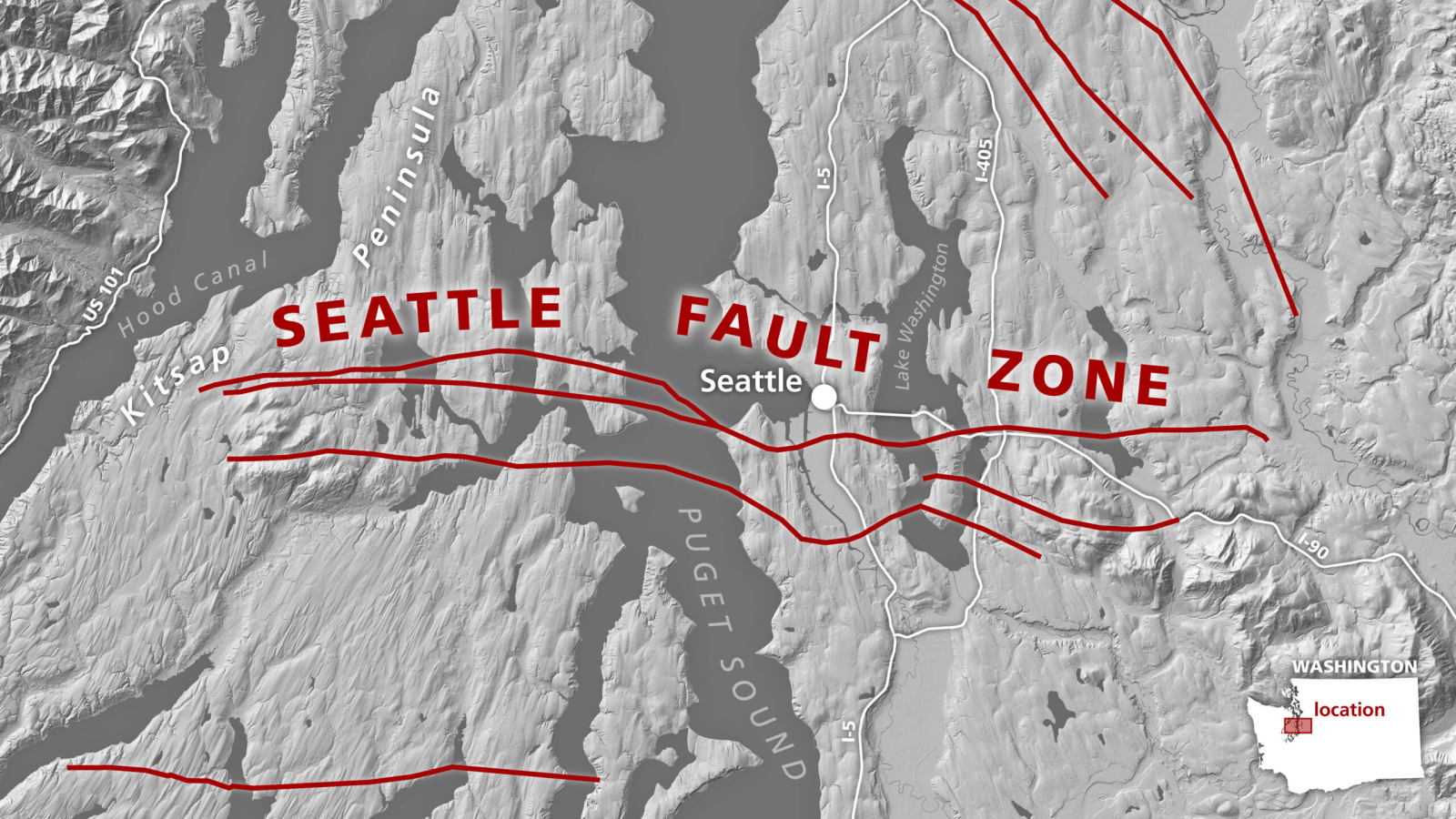
A hazardous fault line that runs south of downtown Seattle may have formed when the edge of the North American continent tore apart 55 million years ago, a new study suggests.
Seattle sits atop the Cascadia Subduction Zone, where the Explorer, Juan de Fuca and Gorda tectonic plates slide beneath the much larger North American Plate. This eastward movement pulled a string of volcanic islands similar to present-day Iceland toward the continent and eventually caused a collision that's still visible in the bedrock beneath the city.
New maps of this bedrock reveal the collision was extremely messy, with the northern half of the island chain riding the oceanic crust and slipping under the continent and the southern half piling onto the continent. The twist in Earth's crust where the islands switched from being subducted to obducted, or added to the top of the continent, would have been under tremendous strain and likely ripped in half.
"It would have been this slow, ongoing tear, almost like the crust unzipping itself," study lead author Megan Anderson, a geophysicist with the Washington Geological Survey, said in a statement. "As this progressed, the tear fault got longer and longer."
Related: Nearly 75% of the US is at risk from damaging earthquakes, new map reveals
The tearing likely ended when the islands finished scrunching into the continent. Anderson and her colleagues tested this scenario using computer models and found that the resulting gash in Earth's crust overlapped perfectly with Seattle's fault line. The wear and tear the surrounding crust would have suffered also aligned with a network of shallow faults beneath the densely populated Puget Lowland area.
Previous research into the region's splintered geological past relied on seismic data, which are sound waves that travel at different speeds underground depending on the layers of rock they encounter.
For the new study, published Feb. 6 in the journal Tectonics, the researchers mapped the density and composition of rocks beneath western Washington state using gravity and magnetic-field measurements. Then, they paired their results with seismic data and collected rock samples to build a clear picture of the area's geology.
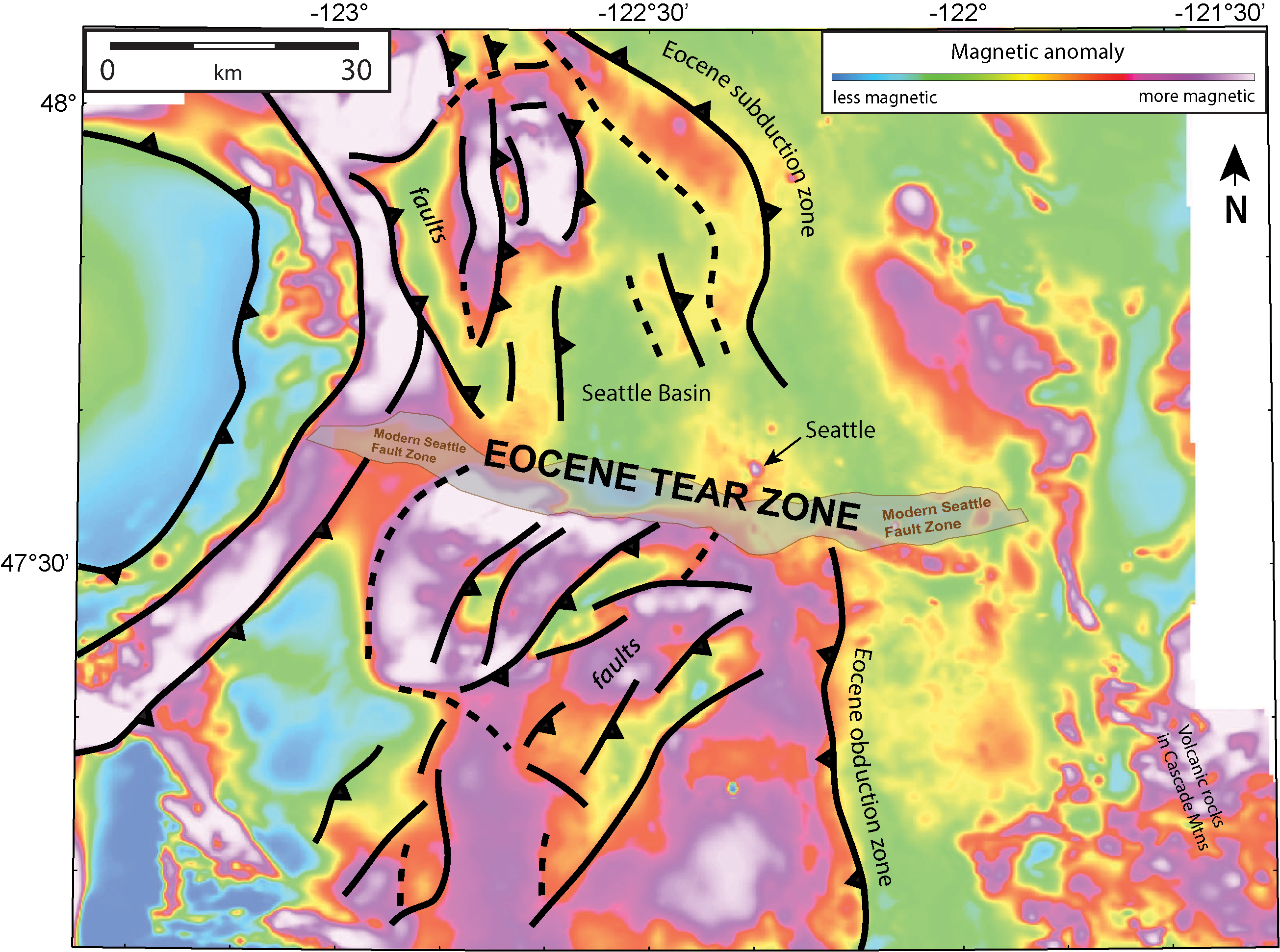
The magnetic data revealed secrets that seismic data alone couldn't have unveiled — namely, that magneticity alternates within the bedrock and that rocks on each side of the Seattle fault line are angled away from each other. Slabs of rock to the north of the fault line lie in a northwest-to-southeast diagonal, whereas slabs to the south are angled from northeast to southwest.
"These are all very different orientations," Anderson said. "It's very hard to do that unless there's a place where the structures get disconnected from each other and then restart."
The results point to a new origin story for the Seattle fault line — one that could help scientists fine-tune their earthquake hazard models. The most recent damaging earthquake in western Washington state was the magnitude 6.8 Nisqually earthquake, which struck in 2001. Massive quakes also occurred in 1700 and around A.D. 900, when the simultaneous rupture of faults shook the Seattle area.
"There's a lot more uncertainty about the Seattle fault than, for example, the San Andreas fault," Anderson said. "The Seattle fault could generate something like a magnitude 7.2 earthquake, and we want to be prepared for it. There's still a lot to learn so that engineering geologists can do better simulations for earthquakes and understand the potential risks to our communities."