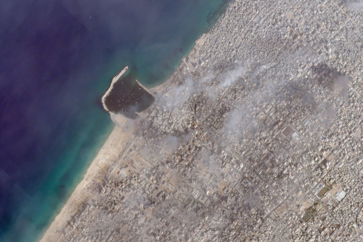
Israeli tanks and armored vehicles pushed further into the Gaza Strip late last week as part of an offensive squeezing Gaza City as fighting raged between its forces and Hamas militants in the coastal enclave, satellite photos analyzed Tuesday by The Associated Press show.
Images from Planet Labs PBC taken Saturday showed Israeli forces just south of the marina in Gaza City, with over three dozen vehicles positioned on the beach. Some stood behind sand berms likely providing some cover.
That position corresponds with AP reporting, as well as an analysis by the Washington-based Institute for the Study of War. The institute attributed those vehicles as belonging to an Israeli push that saw troops cut off Gaza City to the south before reaching the coast of the Mediterranean Sea and moving north toward the marina.
That apparent forward operating base of Israeli forces resembled a similar defensive position seen last week to the north of the marina in images analyzed by the AP. Around all those positions, deep impact craters from missile fire could be seen. Some of them on the beach are now filled with seawater.
The Israeli military did not immediately respond to a request for comment from the AP regarding the satellite photos.
Plumes of smoke could be seen from several sites around Gaza City, some of it passing over Gaza City’s main hospital, Shifa, where several thousand people remain. Israel insists Shifa and other hospitals provide cover to Hamas militant tunnels and command centers. Both Hamas and Shifa staff deny the allegations.
Staff members there have performed surgery on war-wounded patients, including children, without anesthesia as supplies run low.
International law gives hospitals special protections during war. But hospitals can lose those protections if combatants use them to hide fighters or store weapons, according to the International Committee of the Red Cross.
The war began with Hamas’ unprecedented Oct. 7 incursion into southern Israel that killed some 1,200 people. That assault sparked a punishing campaign of airstrikes and the Israeli military offensive into the Gaza Strip that has killed over 11,000 people — two-thirds of them women and children, according to the Health Ministry in the Hamas-run enclave.
After ordering civilians out of Gaza City, Israeli soldiers have moved on the city from three positions.
They cut across the southern edge of the city all the way to the Mediterranean — those troops seen in the images Saturday now farther north. Meanwhile, two other forces have pushed in from the north, with some around Beit Hanoun to the east and others seen in the satellite images along the Mediterranean, to the west.
With journalists outside the city unable to enter, gathering independent information remains difficult.
Apart from videos and images on social media, the growing supply of satellite imagery from commercial companies has become increasingly valuable for reporting on closed-off areas and countries. The AP has a subscription to access Planet Labs imagery to aid its reporting worldwide and distributes those photos to its subscribers and members.