Israeli troops have pushed into Gaza City along a key coastal road on the Mediterranean Sea as part of their war on Hamas, according to satellite images from earlier this week analyzed on Thursday by The Associated Press.
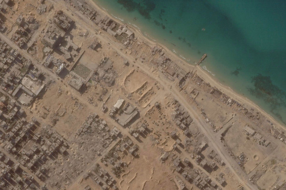
Monday's images from Planet Labs PBC show a moonscape of impact craters from missile strikes and smoke rising over the northern reaches of Gaza City, the besieged territory's largest urban zone. The images also show previous positions of Israeli tanks and armored personnel carriers on one of three axes of attack used to cut the city off from the rest of the Gaza Strip.
The city has seen hundreds of thousands of people flee it after a month of war since Hamas' unprecedented Oct. 7 incursion into southern Israel that killed some 1,400 people.
That assault sparked a punishing campaign of airstrikes and the Israeli military offensive into the Gaza Strip that has so far killed over 10,500 people — two-thirds of them women and children, according to the Health Ministry in the Hamas-run enclave.
Planet Labs has begun delaying the release of imagery from Israel and the Palestinian territories amid the war, as it acknowledged concerns about “the potential for misuse and abuse” of its pictures, said Will Marshall, a co-founder and the CEO of the San Francisco-based firm.
“Planet is continuing to make Earth observation data of Gaza available to clients, including media and humanitarian organizations, consistent with our commitment to transparency and accountability,” Marshall said in responses to questions from the AP ahead of the release of Monday's images. “Planet does not modify imagery, and we have not received requests to censor imagery.”
The AP has a subscription to access Planet Labs imagery to aid its reporting worldwide and distributes those photos to its subscribers and members.
Monday's images show Israeli forces just about a kilometer (over half a mile) north of the Shati refugee camp, a dense neighborhood adjacent to Gaza City’s center. Shati houses Palestinian families who fled from or were driven out of what is now Israel during the 1948 war surrounding its establishment.
Their position corresponds with what witnesses in Gaza City have told the AP, whose reporters continue to work in the Gaza Strip. On Wednesday, one witness told the AP he saw Israeli soldiers fighting Hamas close to Shifa Hospital, which is some 3 kilometers (1.9 miles) from the position Israeli forces held on Monday.
Footage released this week by Hamas of its militants engaged in street-to-street fighting with Israeli forces corresponded to features of the northern reaches of the Gaza Strip. Footage released by the Israeli military did the same.
The Israeli military did not immediately respond to a request for comment from the AP regarding the satellite images.
After ordering civilians out of Gaza City, Israeli soldiers have moved on Gaza City from three positions.
They cut across the southern edge of the city all the way to the Mediterranean Sea. Meanwhile, two other forces have pushed in from the north, with forces around Beit Hanoun to the east and forces seen in the satellite images along the Mediterranean, to the west, according to the Washington-based Institute for the Study of War.
Such “clearing operations frequently take weeks and sometimes months to complete,” the Institute said.
The satellite photos show over half a dozen Israeli tanks and armored vehicles moving on Monday down Ahmed Orabi Street, a coastal road on the Mediterranean also home to a strip of hotels and restaurants. A streetside mosque is seen in ruins.
Some 20 other vehicles just to the north at a site likely serve as a forward-operating base for the Israeli forces, the photos show. A few hundred meters (yards) away, over three dozen impact craters can be seen, likely the result of an earlier intense barrage of fire by Israel to clear the area for its troops.
Burning fires and destroyed buildings can be seen throughout Gaza City.
With journalists outside the city unable to enter, gathering independent information about what's going on remains difficult. Apart from videos and images on social media, the growing supply of satellite imagery from commercial companies has become increasingly valuable for reporting on closed-off areas and countries.
Those companies can shoot highly detailed images that rival those that were once only the domain of a few countries. Airbus and Colorado-based Maxar Technologies have provided images to reporters during the Israel-Hamas war as well. Both firms did not respond to a request for comment.
Previously, a 1996 U.S. law known as the Kyl-Bingaman Amendment barred American firms releasing high-resolution satellite imagery of Israel beyond what was commercially available abroad. But as commercial firms put higher-resolution satellites into space, those images became more widely available.
These newly available images have been used in reporting on Israel before. The AP, relying on such imagery, reported in 2021 that a secretive Israeli nuclear facility at the center of the nation’s undeclared atomic weapons program was undergoing what appears to be its biggest construction project in decades. That work appears to be continuing to this day.