Satellite eye on Earth: September 2011 - in pictures
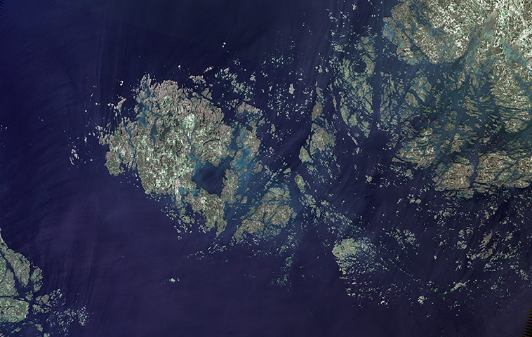
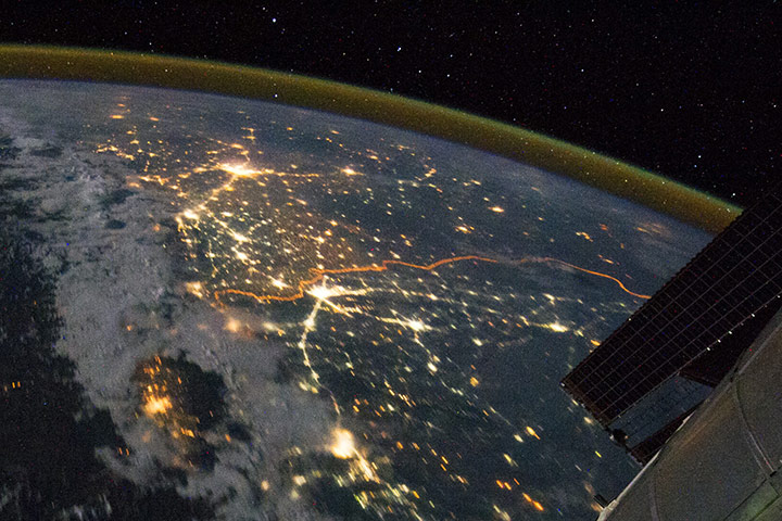
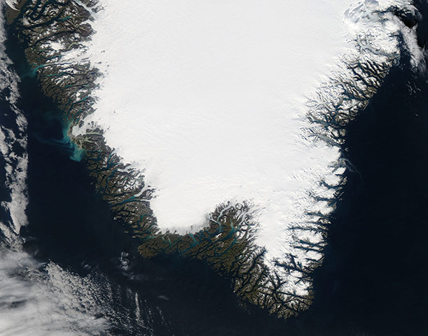
The Åland Islands (also known as the Aaland Islands) lie at the southern end of the Gulf of Bothnia, between Sweden and Finland. The archipelago consists of several large islands and roughly 6,500 small isles, many of them too small for human habitation. Åland vegetation is a combination of pine and deciduous forest, meadows, and farmed fields. On nearly every island, however, the region’s characteristic red rapakivi granite appearsPhotograph: Landsat/NASAClusters of yellow lights on the Indo-Gangetic Plain reveal numerous cities large and small in northern India and northern Pakistan. Of the hundreds of clusters, the largest are the capital cities of Islamabad (bottom), Pakistan, and New Delhi (top), India. The lines of major highways connecting the cities also stand out. More subtle, but still visible at night, are the general outlines of the towering and partly cloud-covered Himalayas to the north (image left). A striking feature is the line of lights, with a distinctly orange hue, snaking across the centre of the image. It appears to be more continuous and brighter than most highways in the view. This is the fenced and floodlit border zone between India and Pakistan, designed to discourage smuggling and arms traffickingPhotograph: ISS/NASAWith the short growing season coming to an end, the coasts of southern Greenland appear mostly ice-free and sport a coating of green vegetation in September. Despite the warm summer and documented thinning of the Southern Greenland ice sheets in recent years, most of the landscape remains dominated by ice. In the fjords, glaciers and ice remain, although the ice and snow is clearly melting, as sediment from the melt discolours the water, bringing tones of green and turquoise to the coastline. Icebergs and sea ice linger in ocean water surrounding Greenland, especially off the tip of the southern coastPhotograph: MODIS/AQUA/NASA
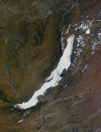
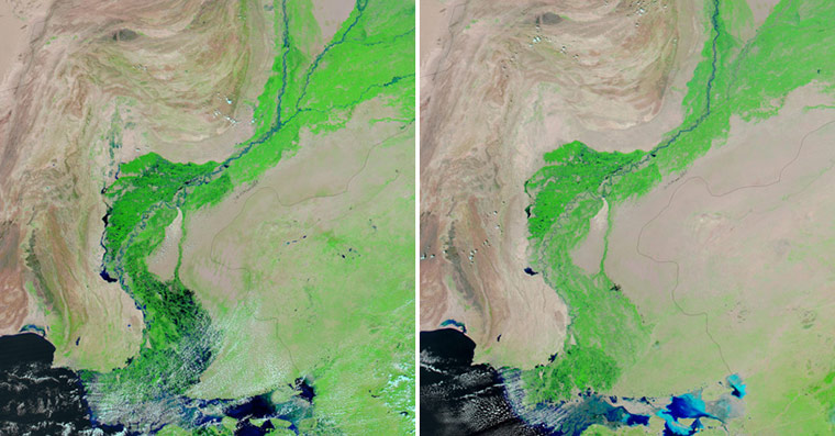
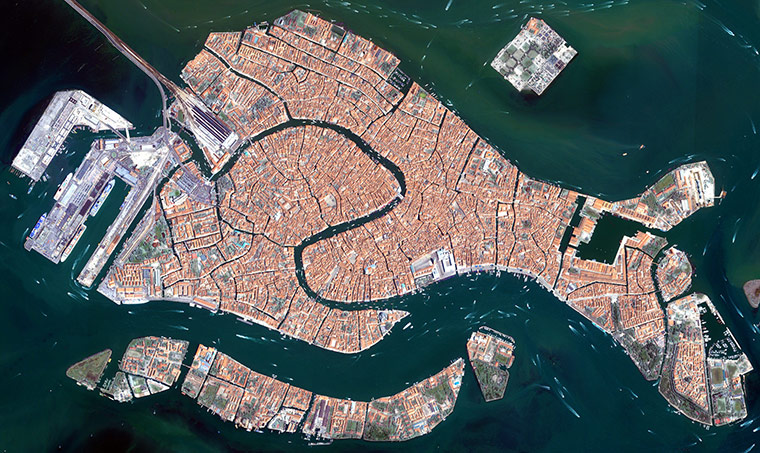
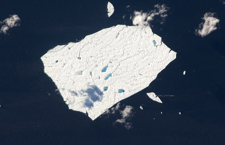
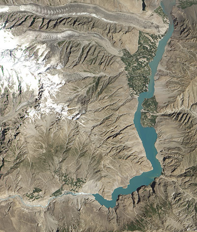
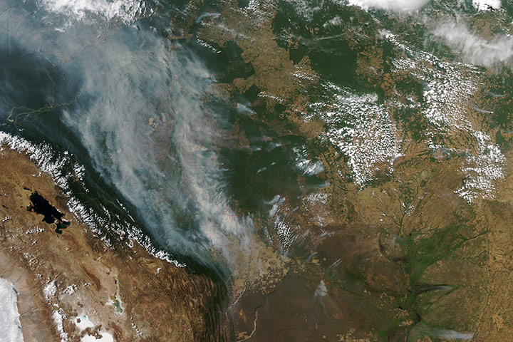
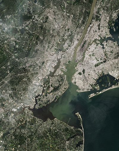
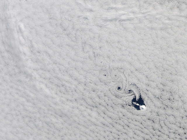
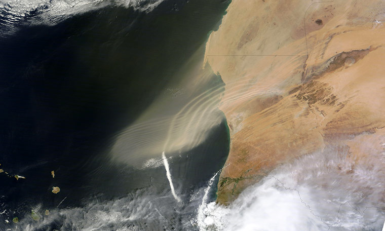
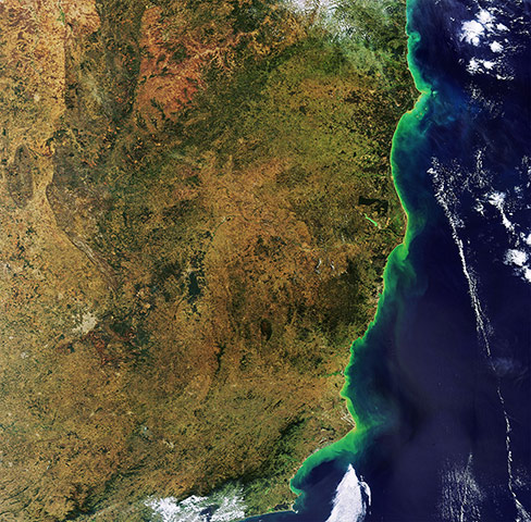
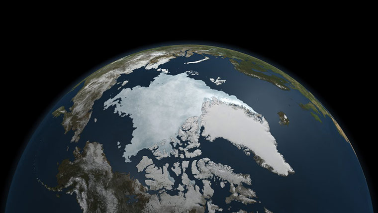
The Amadeus basin in the heart of the Australian outback. Two large rock formations are visible on the lower section of the image. The group of 36 domed rock formations to the west (left) is the Kata Tjuta with the tallest dome, Mount Olga, 1066m above sea level. The white area at the top of the image is the salt-crusted Lake AmadeusPhotograph: ESAFog is essentially a cloud that exists near the Earth's surface, and forms over land or water. This fog, that formed over Lake Baikal in south-eastern Siberia, almost perfectly mimics the lake's area, only thinning at the south-western end, and leaving a few parts of the water surface fog-free. Lake Baikal is 25 million years old and about 1,700m deep, making it the world's oldest and deepest lake. It holds about 20% of Earth's unfrozen fresh waterPhotograph: MODIS/Aqua/NASAFloodwaters lingered in southern Pakistan in late September 2011, where heavy rains inundated Balochistan and Sindh provinces (left). In comparison, the image on the right shows the same region two years earlier. The two images show a portion of the Indus River Valley where it nears the coastPhotograph: MODIS/Aqua/NASAThe islands that make up the Italian city of Venice and the surrounding Venetian Lagoon are pictured in this image. Snaking through the central districts is the Grand Canal, with the Santa Lucia train station at its northern end and Saint Mark's Square at its southern end. Zooming in, we can see water buses and taxis navigating the canal and gondolas docked along the edge. The square island to the north is San Michele. Once a prison island, it became a cemetery when Napoleon’s occupying forces declared burial on the main islands unsanitaryPhotograph: Ikonos-2/ESAAfter more than a year and several thousand kilometers of sailing the seas, Petermann ice island is still drifting in the North Atlantic off the shores of Newfoundland, Canada. Once a hunk of ice fives times the size of Manhattan Island, the ice island has splintered several times since it dropped off the edge of Greenland's Petermann glacier 14 months ago. Spanning roughly 4 x 3.5km, the ice island is covered with melt ponds and streamsPhotograph: ISS/NASAIn January 2010, a landslide struck northern Pakistan’s Hunza Valley, destroying a village and blocking the Hunza River. As water backed up behind the earthen dam, the rising lake forced locals to flee their homes. It also cut off overland access to the outside world by submerging a bridge. Engineers and army labourers carved a spillway through the dam, and water finally began flowing through it in late May 2010. Although the spillway relieved pressure on the landslide lake, the Hunza Valley did not return to normal. This natural-colour image shows the earthen dam and lingering lake behind it. At the south-western end of the lake, whitewater rushes through the spillway. Elsewhere, the water appears blue-greenPhotograph: ALI/EO-1/NASAFires burned throughout Bolivia in early September 2011. Red outlines indicate areas where satellites detected high surface temperatures associated with actively burning fires. In many places, the smoke from these blazes is thick enough to completely hide the land surface below from the satellite sensor's view. In general, the smoke plumes blow toward the west and north-west. Wildfires can occur naturally in Bolivia, but the widespread burning evident in this image likely results from agricultural fires aimed at clearing brush or crop residuePhotograph: MODIS/Aqua/NASAHurricane Katia had diminished to Category 1 strength on the Saffir-Simpson scale by the time this astronaut photograph was taken, but it still presented an impressive cloud circulation as its center passed the north-eastern coast of the United States on 9 SeptemberPhotograph: ISS/NASAIn the wake of heavy rains from Hurricane Irene, sediment filled many rivers and bays along the US east coast. New York’s Hudson River and estuary was no exception. In this true-colour satellite image, pale green and tan water flows past Manhattan and mixes with the darker waters of New York harbour and the Atlantic OceanPhotograph: Landsat/NASAHeard Island is located in a windy and remote part of the southern Indian Ocean, near the meeting point of more temperate sub-Antarctic surface waters and colder Antarctic surface waters. It is far from any large land mass, lying about 1,550km north of Antarctica and over 4,000km south-west of Australia. Surrounded by oceans, the relative humidity near the island is very high - usually around 80%. This high humidity along with the prevailing strong westerly winds known as the 'furious fifties', create excellent conditions for persistent cloud cover. The rugged and steep topography creates spectacular images in the cloudsPhotograph: MODIS/Terra/NASADust plumes blew off the west coast of Africa and over the Atlantic Ocean in late September. The plumes sport a wave-like appearance as bands of thick dust alternate with bands of relatively clear air. Some waves extend westward while others curve toward the south in giant arcs. At the end of one curving wave of dust, a line of clouds extends southward over the sea. These ribbon-like patterns might result from atmospheric waves. Sand seas sprawl over much of Mauritania, and the abundant sand provides plentiful material for dust storms. This dust storm has not yet reached Cape Verde, which lies to the south-west, but the dust appears headed in that general directionPhotograph: MODIS/Terra/NASAA portion of three Brazilian states along the Atlantic coast: Rio de Janeiro, Espírito Santo and southern Bahia. To the south, clouds cover the country’s second largest city, Rio de Janeiro. Much of the area pictured is covered by the Atlantic Forest – or Mata Atlântica – a region containing a diverse and unique mix of vegetation and forest typesPhotograph: Envisat/ESAEvery year, the frozen Arctic Ocean emerges from winter and thaws under the 24-hour light of the summer sun. Each year is different: sometimes ice retreats from the shores in dramatic fashion and other years have a more gradual melt. 2011 proved to be a year of extreme melt. By early September, the area covered by sea ice in the Arctic Ocean was approaching a record low. On 9 September, the sea ice extent was very close to the record low set in 2007, according to the National Snow and Ice Data Center (NSIDC). Scientists at the University of Bremen, who use a slightly different method to calculate sea ice extent from AMSR-E measurements, declared that 2011 surpassed 2007, setting a new record lowPhotograph: Aqua/NASA
Sign up to read this article
Read news from 100’s of titles, curated specifically for you.


.png?w=600)