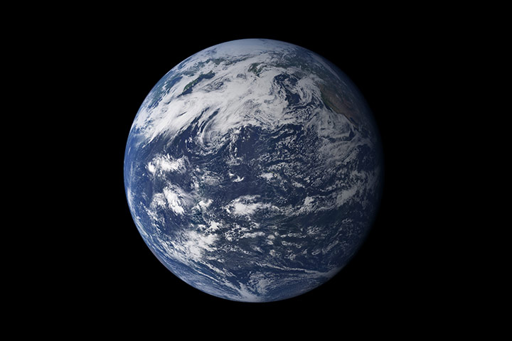
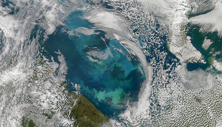
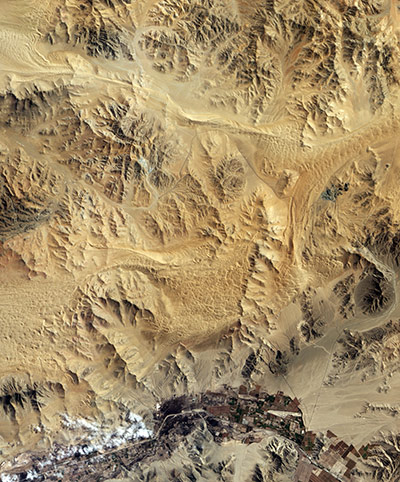
Viewed from space, the most striking feature of our planet is the water. In liquid and frozen form, it covers 75% of the Earth's surface. Altogether, the Earth's water content is about 1.39bn cubic kilometres (331m cubic miles), with the bulk of it (about 96.5%) in the oceans. The rest (approximately 1.7%) is stored in polar ice caps, glaciers, and permanent snow, and another 1.7% in groundwater, lakes, rivers, streams, and soilPhotograph: MODIS/Terra/NASAThe Barents Sea swirls with turquoise, teal, navy and green - colours created by a massive phytoplankton bloom made up of millions of tiny, light-reflecting organisms growing in the sunlit surface waters. Such blooms peak every August in the sea. The variations in colour are caused by different species and concentrations of phytoplankton. The bright blue colors are probably from coccolithophores, a type of phytoplankton that is coated in a chalky shell that reflects light, turning the ocean a milky turquoise. Shades of green are likely from diatomsPhotograph: NASAIn early August 2010, Chile’s San José copper and gold mine collapsed, trapping 33 miners underground. Seventeen days later, the miners’ friends and families were overjoyed to learn that the men had survived. However, the good news came with a caveat: rescuing the miners might take months. The San José mine lies north of the city of Copiapó, Chile, in the world’s driest desert, the Atacama. The mine complex appears, on this view taken on 16 September, 2010, as an uneven patch of grey in the midst of camel-coloured hills devoid of vegetation. This week it was announced that the miners could be out within 10 days, in a dramatic acceleration of the rescue plansPhotograph: ALI/EO-1/NASA
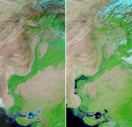
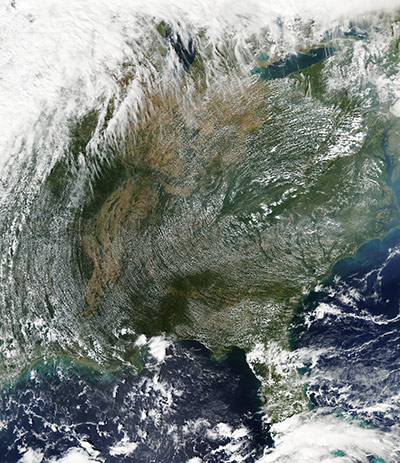
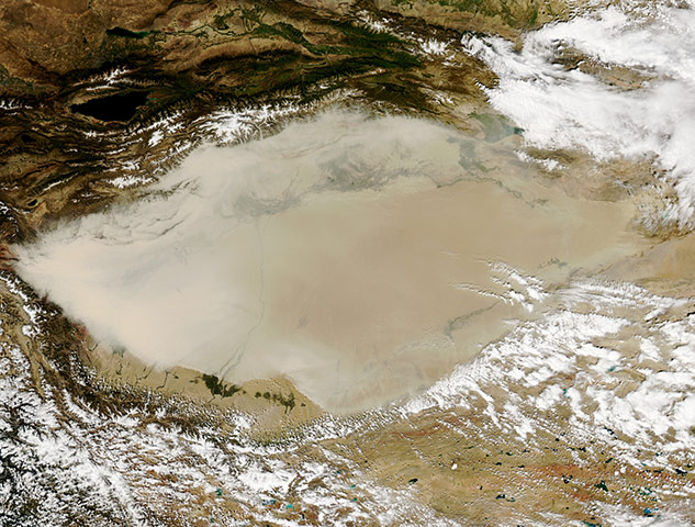
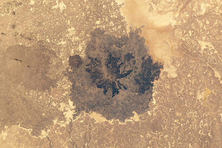
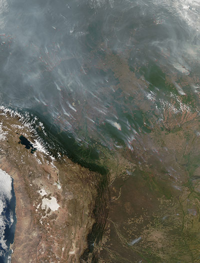
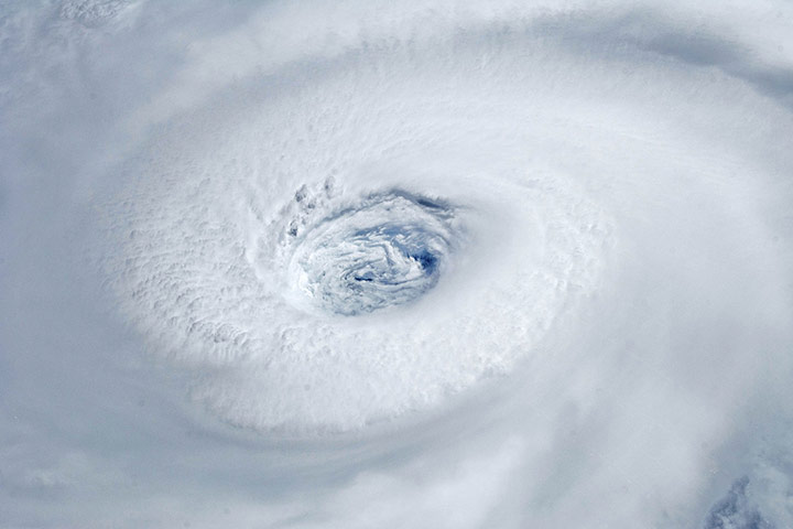
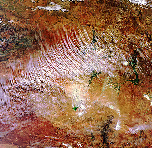
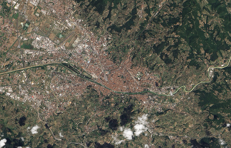
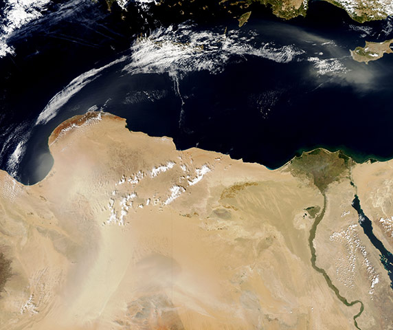
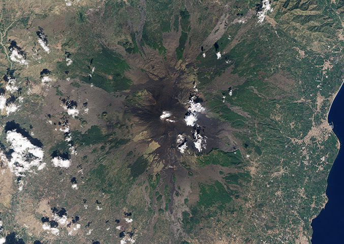
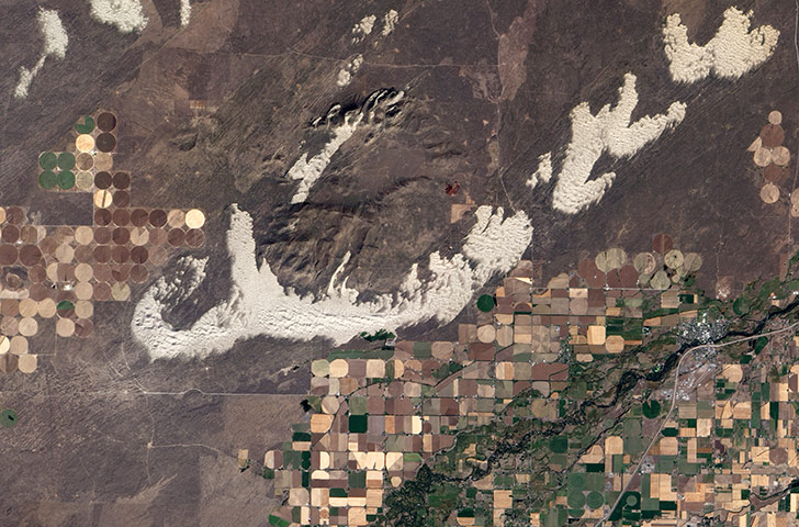
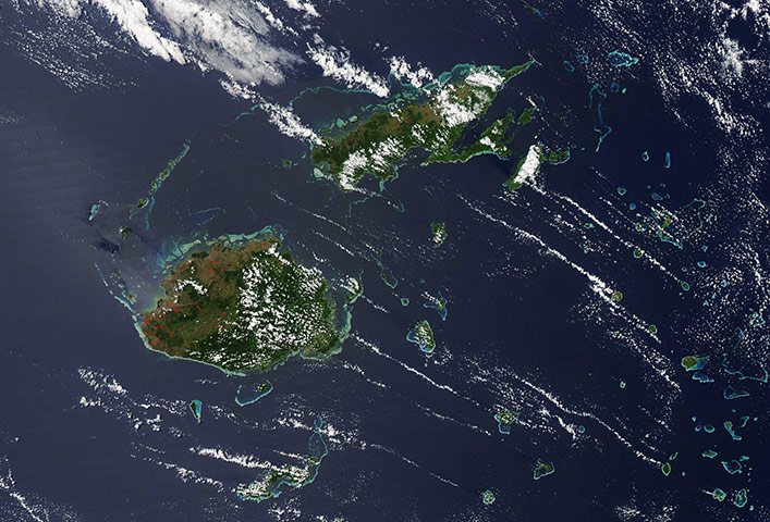
Images of the Indus river, from 23 September, 2010 on the right, and the same date in 2009 on the left. Floodwaters had begun to recede along the Indus river by late September, although high waters remained in a massive floodwater lake west of the Indus, terminating in Manchhar lakePhotograph: MODIS/Terra/NASAA pinwheel-like pattern of high pressure clouds stretches across the eastern United States on 23 September 2010. The high-pressure weather system that brought fair weather and relatively clear skies to the United States also created this atmospheric art. The circular pattern to the clouds, stretching from Ohio to Florida and from Arkansas to the Atlantic Coast, was caused by the flow of air around a sprawling high-pressure ridge centered in western Virginia, North Carolina, and eastern TennesseePhotograph: MODIS/Aqua/NASAA thick tan dust blanketed China's Taklimakan desert on 5 September, 2010. The dust was especially thick along the western perimeter of the desert. Toward the desert's eastern end, the dust thinned. Only a thin layer of dust travels over land outside of the eastern edge of the desert, indicating that the dust may be lying low over the arid land, rather than rising high in the atmosphere. The Taklimakan is the largest, driest and highest desert in China, filling the Tarim basin between the Tien Shan mountains to the north and Kunlun mountains to the south. It is located further from the ocean than almost any other place on Earth, and is cut off from the Asian monsoons and Arctic storms by the encircling mountainsPhotograph: MODIS/Aqua/NASAEs Safa is a striking basaltic volcanic field located to the south-east of Damascus, Syria. It lies within the larger Harrat Ash Shamah, the largest volcanic field on the Arabian tectonic plate. Es Safa contains numerous vents that have been active during the holocene epoch (beginning approximately 12,000 years ago). The most recent recorded activity was a boiling lava lake observed in the area around 1850. The dark lava flow field (centre) likely represents the latest activity of the volcanic field, and is emplaced over older, lighter coloured flows. Cinder cones are scattered throughout the Es Safa field, but many are aligned along north-west-south-east trends that likely indicate faults through which magma rose to the surface. Two such alignments are visible in the left of the image. To the south-east (image right) a small reservoir feeds water distribution ditches extending northwardsPhotograph: ISS/NASARain dampened most of the fires raging throughout Bolivia in early September 2010, but the fire disaster was not entirely over. By 8 September, sunny skies had returned and more than 500 fires burned in Bolivia, said the government. At the height of the fire emergency, the government had reported nearly 40,000 fires. In this image, the fires (outlined in red) were concentrated in the state of Santa Cruz. The majority of the fires burn outside the dark green rainforest either on the edge of the forest or on brown land that had previously been cleared. These fires were probably started deliberately, since fire is a common land management practice in the Amazon basin. The fire emergency developed in Bolivia because of extreme drought: the lack of moisture meant that even Bolivia's rainforests were vulnerablePhotograph: MODIS/Aqua/NASAThe eye of hurricane Igor on 14 September, 2010, a category four hurricane. At the time this was taken, Igor was centered in the Atlantic Ocean and slowly moving west-northwest with maximum sustained winds of 213kphPhotograph: ISS/NASAThe Lake Eyre basin, one of the world's largest internally draining systems, in the heart of Australia. White cloud streaks stand in contrast to the vast amounts of crimson soil and sparse greenery of the "red centre". The basin covers about 1.2 million sq km (about the size of France, Germany and Italy combined), including large portions of South Australia (bottom), the Northern Territory (upper left) and Queensland (upper right) and a part of western New South Wales (bottom right)Photograph: MERIS/Envisat/ESAAround the year 59BC, Julius Caesar established a settlement for his veteran troops in the fertile river valley of the Arno. The same site had likely already been an Etruscan settlement and, by some speculation, occupied since prehistoric times. Although its population waxed and waned, the city persisted and, starting some 14 centuries after its founding, flourished as a centre for commerce, art, and science. Florence (Firenze) is credited as the birthplace of the renaissance. The west-flowing Arno runs through the middle of the image and the centre of the city. Over the centuries, Florence's location proved optimal for agriculture and trade. Today, multiple bridges connect the northern and southern halves of Florence across the Arno. Spanning the river at its narrowest point is the Ponte Vecchio (Old Bridge) that lasted since 1345Photograph: ALI/EO-1/NASAJust a few days after dust plumes blew off the coast of Libya, another dust storm spread over Egypt, Libya, and the Mediterranean Sea on 1 October. The dust is thickest over central Libya, where the dust takes on a rippled pattern. Thinner but still discernible dust appears in Egypt. Over the Mediterranean Sea, dust and clouds form a massive arc that extends eastward toward CyprusPhotograph: MODIS/Aqua/NASARivers of water and ice flow across the landscape north of Anchorage, Alaska, where summer is fleeting and fall arrives early. Snowy peaks of the Alaska range, Mount McKinley, among them, form an arc in the bottom right of the image. Though not as tall as Mount Everest when measured from sea level, McKinley has the greatest elevation between its base and summit, and it is the tallest mountain in North America. To the south lie the Wrangell mountains, including Mount Blackburn, and the Chugach mountains, including Mount Witherspoon. All of the ranges are topped with networks of glaciers, some of them terminating in lakesPhotograph: MODIS/Terra/NASAA view of the north coast of the Caspian Sea and two river deltas in Kazakhstan and Russia on 11 September, 2010. The larger delta (image middle) is that of the Volga river, which appears prominently in sunglint, light reflected off a water surface back towards the observer, and the smaller, less prominent delta is the Ural river (lower left). The smoke plume appears to rise out of coastal marsh vegetation in the Ural river delta, rather than a city or oil storage facility. Although even small fires produce plumes that are long, bright, and easily visible from space, the density of the smoke in this plume, which stretches 350km (217 miles), suggests it was a significant fire. The smoke was thick enough near the source to cast shadows on the Caspian Sea surface belowPhotograph: ISS/NASAEven in the absence of an eruption, there are signs of activity at the summit of Mount Etna, Europe’s most active volcano. Water vapour and other volcanic gases overflow Etna’s summit craters, spilling out over the volcano’s upper slopes. A steam plume rises from a collapse pit that formed in late 2009, the newest volcanic feature on Etna. Dark lava flows from recent eruptions cover the peak, overlaying lighter, weathered flows from hundreds or thousands of years ago. (Numbers on the image indicate when a flow was erupted.) The oldest lavas are covered by green vegetation. Eruptive cones and fissures also dot the landscape. Although Etna is not currently erupting lava or ash, there is more activity than just gas emissions. Frequent explosions deep within the north-east crater, which may presage an upcoming eruption, are audible at the summit. These explosions were occurring sporadically every few minutes, as recorded by nearby seismometersPhotograph: ALI/EO-1/NASADriving down Highway 20 from Idaho Falls toward Yellowstone national park, green and golden fields flash past the car windows, interrupted only briefly by small towns. Across the Snake river, the farms give way abruptly to mountains of fine, white sand more akin to the Sahara desert than the fertile river plain. The out-of-place dunes hint at a time when the climate of eastern Idaho was far different than it is today. The dunes spill across the Snake river plain in a wide arc in this image from 25 September. The dunes formed about 10,000 years ago, at the end of the last ice age when the Earth’s climate shifted. Eastern Idaho’s climate became warmer and drier. Lakes shrank, exposing fine sand. Persistent winds from the south-west blew the sand north-east across the lava plainPhotograph: ALI/EO-1/NASADozens of red hotspots dot the western slopes of the islands of Fiji and Vanua Levu, two of the larger islands in the Republic of Fiji's volcanic archipelago, which contains over 332 islands and over 500 small islets, on 20 September, 2010. Viti Levu is the southernmost island in this image; Vanua Levu lies to the north. The vegetation on west coast of the islands, where most of the hotspots are found, is primarily savannah grassland. Large areas of grassland do burn naturally each year on the islands, but the primary cause of fire is from human activityPhotograph: MODIS/Aqua/NASA
Sign up to read this article
Read news from 100’s of titles, curated specifically for you.