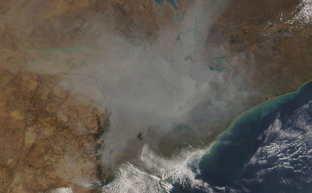
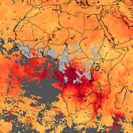
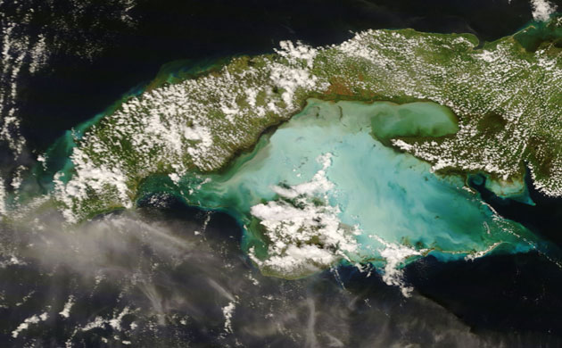
Fires in Africa, September 11, 2008: In southern Africa, people light thousands of fires for managing crop and pasture land during the annual dry season. In this image detected fires are marked in red, while smoke is thick over central Mozambique, Zimbabwe and MalawiPhotograph: Nasa/NasaCarbon monoxide over Africa, August 25 to September 1, 2008: Such fires have a strong influence on local climate and air quality. One way to track the impact of these fires on atmospheric chemistry is through observations carbon monoxide concentrations, revealed here in red. The high concentration of CO off the west of the continent is from agricultural burning in Angola and neighbouring countries. The CO over south-east Africa is linked to fires in Mozambique and South AfricaPhotograph: Nasa/NasaStormy waters off Cuba, September 1, 2008: Hurricane Gustav came ashore over Cuba as a category four storm with winds of 240kph, damaging an estimated 100,000 buildings. This image shows storm-churned water around the west of the country. Normally turquoise, the shallow waters of the Caribbean are white - Gustav churned the water, bringing sand to the surface. Muddy water near the shore is where sediment has washed into the gulfPhotograph: Nasa/Nasa
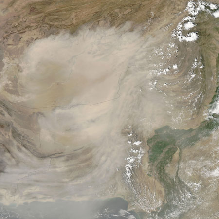
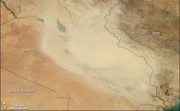
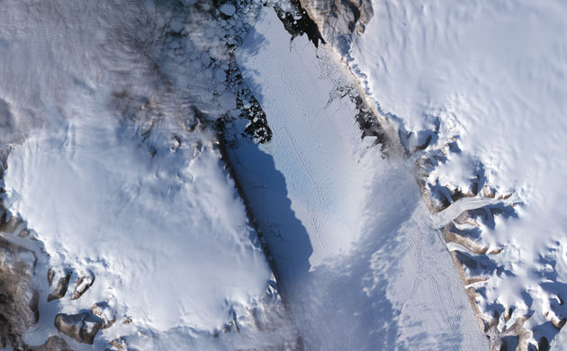
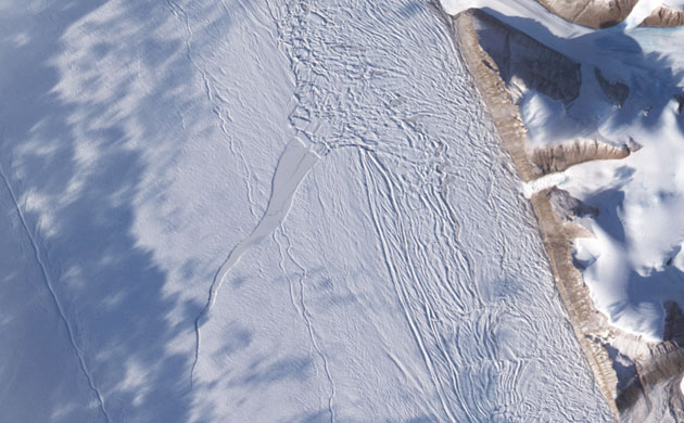
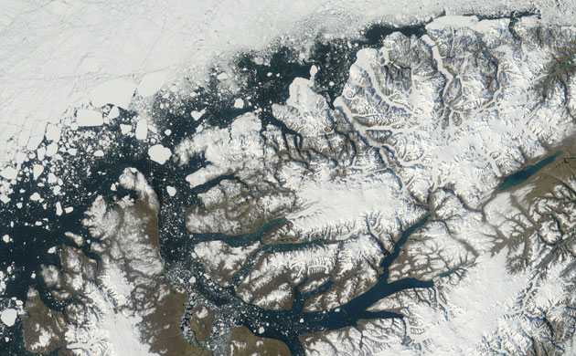
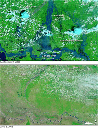
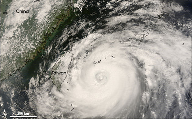
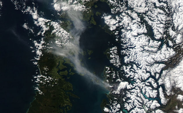
Dust storm over Afghanistan, September 7, 2008: After forming over the borders between Iran, Afghanistan, and Pakistan, a dust storm that began on September 5 expanded north and south. The storm may have formed from salt lake and sand sea sediments along the borders between the three nations. Thick dust plumes blow east in a slightly clockwise motion. Thinner plumes also blow southward, reaching past the coastlines of Iran and PakistanPhotograph: Nasa/NasaDust storm over Iraq, September 16, 2008: A massive cloud of dust hovered over Iraq in mid-September 2008. In this true-colour, photo-like image, a nearly uniform cloud of dust obscures the view of north-eastern Iraq and a small portion of Iran. The source area for the dust storm are not obvious from this image, although the fine sediments of the Tigris and Euphrates floodplain provide plenty of material for dust storms in the regionPhotograph: Nasa/NasaPetermann glacier, north-west Greenland, September 7, 2008: Scientists are using satellite imagery to monitor the seasonal calving of the northern hemisphere’s largest floating ice tongue. They are concerned about a fracture, visible in the bottom right of the image, which may lead to the glacier losing one third of its current lengthPhotograph: Nasa/NasaA close up of the crack that is concerning scientists on the Petermann glacier, Greenland. Satellite images from the 1990s show that rifts have developed in this region more than once, but previous rifts evolved differently to this one, which has grown wider and longerPhotograph: Nasa/NasaEllesmere ice shelves, Canadian Arctic, August 29 2008: Prior to July 2008, only five ice shelves remained in the Canadian Arctic. At 4,500 years old they were the remnants of a once-massive "glacial fringe" that explorer Robert Peary witnessed in the early 20th century. In July 2008, a new wave of ice shelf disintegration began and by late August the ice shelves had lost a total of 214 sq kmPhotograph: Nasa/NasaMonsoon floods in north-east India, September 2, 2008: Monsoon rains swelled rivers in north-eastern India in September. The Ganges was high, as it usually is during the monsoon, but the Kosi’s burst barriers in Nepal and flowed into a long disused channel on August 18. Two weeks later, the flooded channel of the Kosi river (centre) had spread across miles of Indian countryside. The flood rejoins the rest of the Kosi river immediately before emptying into the GangesPhotograph: Nasa/NasaTyphoon Sinlaku, September 12, 2008: Sinlaku skirted Taiwan with winds of 204kph (127mph), making it the equivalent of a category three hurricane, but did not strike landPhotograph: Nasa/NasaChaitén in Chile, September 3, 2008: Chaitén erupted in May 2008 blanketing the region in volcanic ash and releasing plumes of ash and steam. In early September, the volcano released another plume, seen here drifting north-west. Chaitén is a caldera volcano, formed when the magma chamber completely empties during an eruption, causing the summit to collapse. Before this year’s eruptions, Chaitén had been dormant for more than 9,000 yearsPhotograph: Nasa/Nasa
Sign up to read this article
Read news from 100’s of titles, curated specifically for you.