Satellite eye on Earth: October 2012 – in pictures
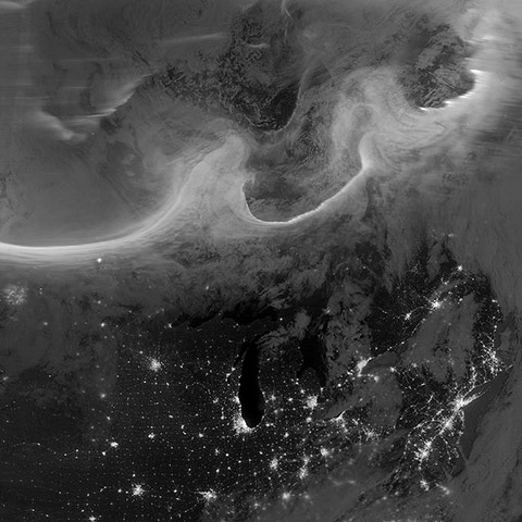
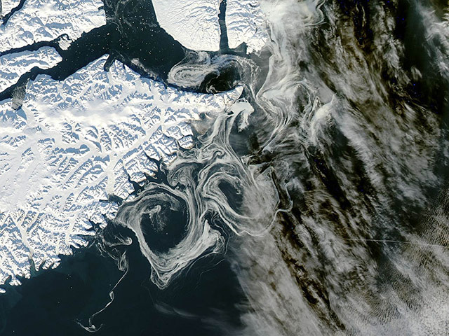
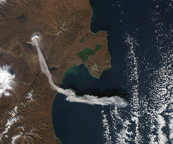
Auroras over north America as seen from space. Overnight on 4-5 October, a mass of energetic particles from the atmosphere of the sun were flung out into space, a phenomenon known as a coronal mass ejection. Three days later, the storm from the sun stirred up the magnetic field around earth and produced gorgeous displays of northern lightsPhotograph: VIIRS/Suomi NPP/NASASea water off the east coast of Greenland looking a bit like marbled paperPhotograph: MODIS/Aqua/NASAWhen Nasa’s Terra satellite passed over Russia’s Kamchatka peninsula at noon local time on 6 October, the Shilveluch volcano was quiet. By the time Nasa’s Aqua satellite passed over the area two hours later, the volcano had erupted and sent a plume of ash over the Kamchatskiy Zaliv. The plume traveled about 90km (55 miles) toward the south/south-east, where a change in wind direction pushed it eastwardPhotograph: MODIS/Aqua/NASA
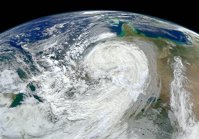
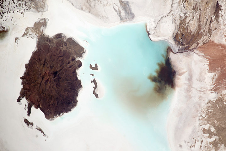
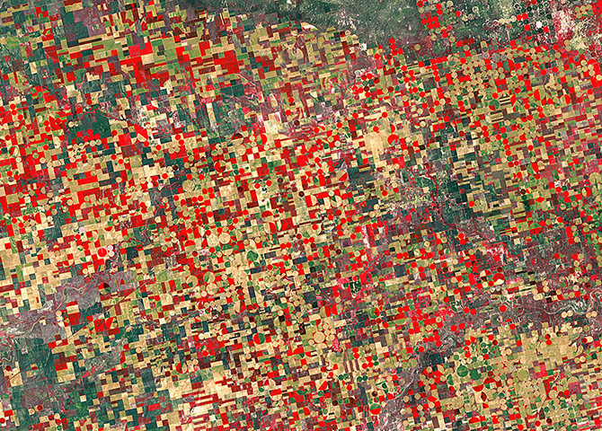
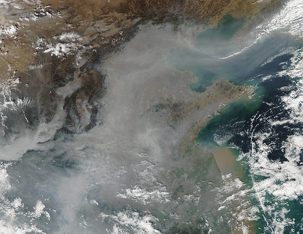
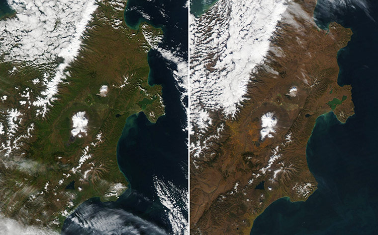
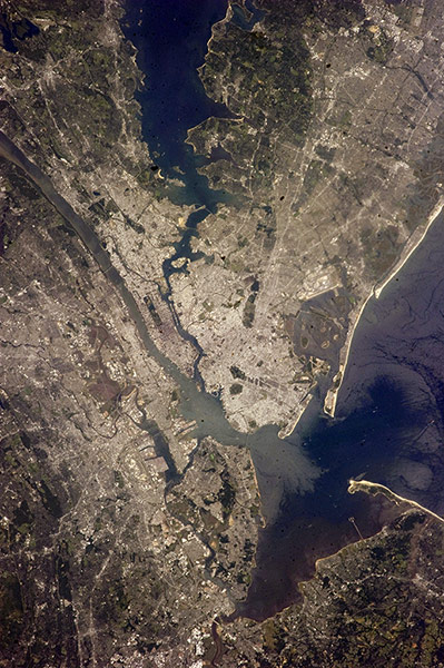
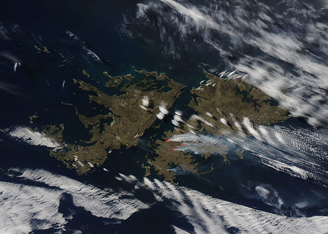
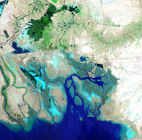
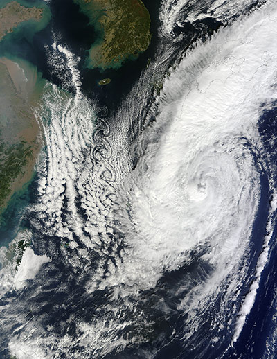
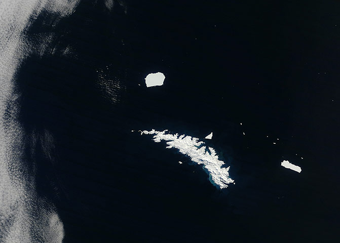
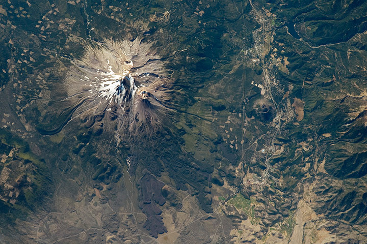
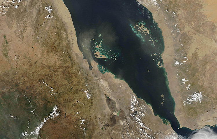
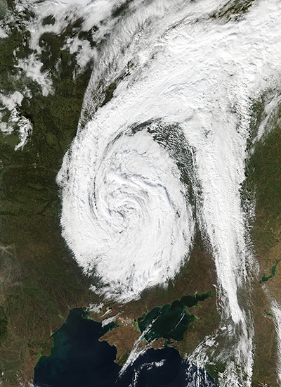
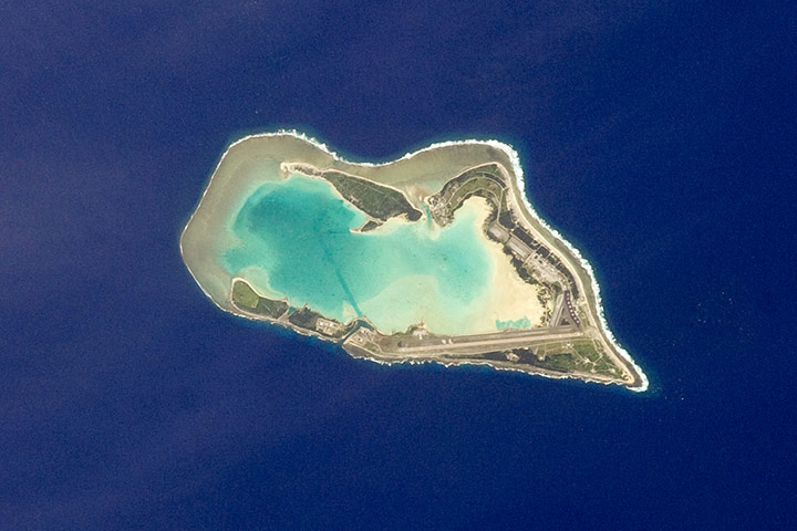
As superstorm Sandy moved north along the east coast of the United States, its waves churned up sediments from the continental shelf and left turbid water in its wake. By midday on 30 October, the skies over coastal Florida, Georgia and South Carolina had cleared enough to reveal that turbidity. Note that the image is rotated so that you are looking south from CanadaPhotograph: VIIRS/Suomi NPP/NASAThe Salar de Coipasa, located in the Altiplano region of western Bolivia, covers an area of approximately 2,500 sq km (960 sq miles) and is located north-west of the largest salt flat in the world, Salar de Uyuni. At Coipasa, a crust composed of halite – common table salt – provides the brilliant white coloration characteristic of the Altiplano salarsPhotograph: ISS/NASAThis false-colour Landsat-5 image shows agricultural structures in the US state of Kansas. The cropland is divided into circles and rectangles due to the different types of irrigation systems. The false colour makes vegetation look mostly red and brown in this image, allowing for better discrimination between different vegetation types. In the bottom right corner, the agricultural patchwork breaks for the Cimarron River. In the central right portion of the image is the city of UlyssesPhotograph: Landsat-5/ESAThick haze hovered over eastern China on 20 October. The haze stretched from Beijing southward, covering much of the coastal plain bordering Bo Hai and the Yellow SeaPhotograph: MODIS/Aqua/NASAWith temperatures dropping in the northern hemisphere, autumn colours swept across the Taiga forests of Russia's Kamchatka peninsula in September and October. Within a span of 11 days, the forests of far eastern Siberia went from green to deep brownPhotograph: MODIS/Aqua/NASAWith a population in the metropolitan New York of 18.9 million (2011 figures from Census Bureau), and in the city of some 8.25 million, the New York city area is one of the leading commercial, financial, cultural, and communication centres in the world. The sediment-laden Hudson River enters the scene near the bottom left (north) of the image and can be seen flowing south emptying into Upper and Lower New York Bays (right of centre). Much of Long Island is visible extending to the east at centre and upper left of the image. Right (west) of the Hudson River, much of the state of New Jersey and the Newark metropolitan area are visible. Sandy Hook in New Jersey can be seen in the upper right quadrant of the image. Central Park on Manhattan can be seen below and just to the left of centre as a dark rectangular patchPhotograph: ISS/NASAWildfires on East Falkland Island. Actively burning areas, detected by Modis thermal bands, are outlined in red and are accompanied by broad plumes of smoke. Most of the fires are located in Lafonia, which has been used for sheep farming since the early 19th century. Open grasslands provide excellent pasture, and are most nourishing when they are lush and green. To improve pasture, fires are set in spring to burn the old, drier winter grass in order to encourage new growthPhotograph: MODIS/Aqua/NASAThe southern Ukrainian coast along the Black Sea. The green and yellow patchwork of agriculture dominates the land, while blue swirls of sediment and phytoplankton are present along parts of the coast. The Black Sea, bordered by Romania, Bulgaria, Turkey, Russia, Georgia and Ukraine, is almost cut off completely from the rest of the world's other oceans, yet it reaches depths of more than 2,000m. The straits of Bosporus and Dardanelle connect the Black Sea to the Mediterranean SeaPhotograph: SPOT-5/ESAThis image shows the northern end of the Persian Gulf, along with the border of Iran and Iraq and the mouth of the Shatt al-Arab River. In the lower-left corner, we can see the Shatt al-Arab where it creates part of the border with Iraq. The lines cutting through the middle of the image are roads, as well as the Trans-Iranian Railway. The centre of the image is dominated by the marshes and mudflats of the Shadegan wildlife refuge, Iran's largest wetlandPhotograph: Enhanced Thematic Mapper/Landsat 7/ESATropical storm Prapiroon began life as a tropical depression in the western Pacific on 5 October, then it was upgraded to a tropical storm on 7 October. This image shows spiral eddies formed as the decaying typhoon moved east/north-east over the Pacific Ocean. The air-flow obstacle responsible for these vortices was likely Cheju (Jeju) Island. A volcanic peak on Cheju, Halla Mountain, rises to 1,950m above sea level. The spiral eddies extended about 720 km south of the islandPhotograph: MODIS/Terra/NASAUnusually clear skies allowed an unobstructed view of a snow-and-ice covered South Georgia Island. As Modis passed overhead, two big icebergs and a number of smaller ice chunks floated around the island. Off the island’s north-western tip was Iceberg C-19C, measuring 35 by 28km. The iceberg is a remnant of the larger Iceberg C-19, which calved off Antarctica’s Ross ice shelf in May 2002Photograph: MODIS/Terra/NASAThe Cascade Range includes many impressive stratovolcanoes along its north-south extent, some active during the past few hundred years. Mount Shasta in northern California is among the largest and most active (over the past 4,000 years). The summit peak stands at an elevation of 4,317m above sea level, and is formed by the Hotlum cone. Shasta’s summit is high enough to retain snow cover throughout the year, and several small glaciers are present along the upper slopesPhotograph: ISS/NASAWedged between Sudan in the north and Ethiopia in the south, Eritrea is a fairly small country, but it holds a variety of landscapes and climates. The central highlands have a temperate climate, and most of the country’s population lives in that region. Conditions are drier outside the highlands, particularly along the Red Sea coast, where dust storms occasionally blow over the ocean. Arising near the coast, this image shows dust plumes stretched northward over the Massawa ChannelPhotograph: MODIS/Aqua/NASAOn 18 October, Nasa’s Aqua satellite observed a low-pressure system over eastern Europe. Cloud-free skies all around the system allowed Modis a clear view of the weather event. The spiral-shaped storm straddled the border between Russia and Ukraine, and clouds extended just west of Ukraine’s capital city of Kyiv (Kiev)Photograph: Modis/Aqua/NASAThe atoll of Wake Island is located in the central Pacific Ocean, south-west of Hawaii and north-west of Guam. The atoll includes the smaller Peale Island and Wilkes Island, for a total land surface area of 6.5 sq km. Like many atolls in the Pacific, the islands and associated reefs formed around a submerged volcano. The lagoon in the centre marks the approximate location of the summit crater. Wake Island was annexed by the United States of America in 1899, and it became an important military and commercial airfield by 1935. Following the bombing of Pearl Harbour in 1941, the atoll was occupied by Japanese forces until the end of world war two in the Pacific. Today, the civil administration of the atoll is the responsibility of the US Department of the InteriorPhotograph: ISS/NASA
Sign up to read this article
Read news from 100’s of titles, curated specifically for you.