Satellite eye on Earth: October 2011 – in pictures
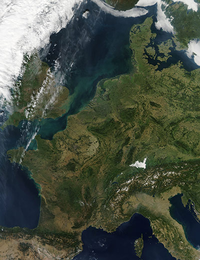
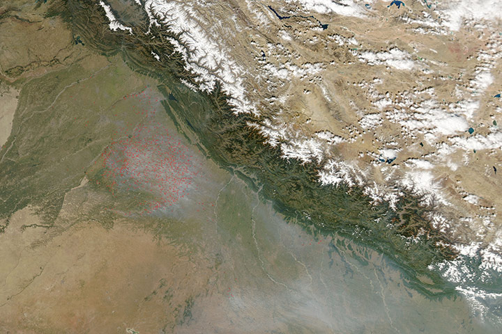
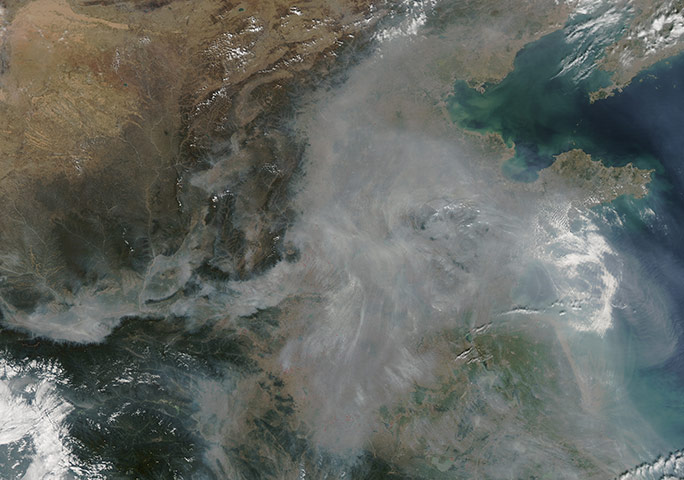
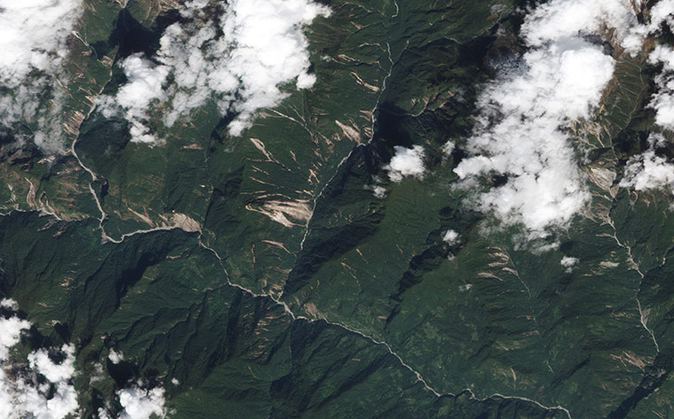
The colours of a changing autumn landscape across western Europe on 1 October 2011 on a sunny afternoon. In some areas across the region, the dark greens of summer forest are gently softened by pale greens and yellows of senescent leaves of deciduous trees. In the south, the Alps are covered by a coating of snow. North of the Alps, a bright white patch with soft edges can be seen. This is not snow, but a layer of late afternoon fog that covers Bodensee (Lake Constance) and fills the nearby valleys. Bodensee's shores are shared by three countries. At the extreme south-eastern corner is Austria. Germany lies to the north and Switzerland to the south. Although the lake is only about 8.7 miles across at the widest point, the view is frequently obstructed by haze and fogPhotograph: Aqua/NASANorthern Namibia is known for its widespread bare and sinuous parallel dunes, most of them redPhotograph: ASTER/Terra/NASAThe fire season was well under way in northern India as many dozens of fires burned near the Pakistan border on 27 October. Most of the fires are located in the Punjab region, which makes up only about 2% of the country's land, but provides more than 50% of its grains. During monsoon season, which normally runs from June to November, heavy rainfall makes farming difficult. As the rains end, farmers begin to clear land for summer crops. One of the most important tools used to prepare land for cropping, in the traditional agricultural system, is fire. Although fire does remove brush, it has detrimental effects. The most obvious is air pollution. The smoke from the agricultural fires can be seen blowing to the south-east, covering the land with a substantial veil of smoke. The Himalaya Mountains form a strong barrier to air movement, trapping smoky air on the southern side, where it accumulates and mingles with pollution from industry and carsPhotograph: MODIS/Aqua/NASA
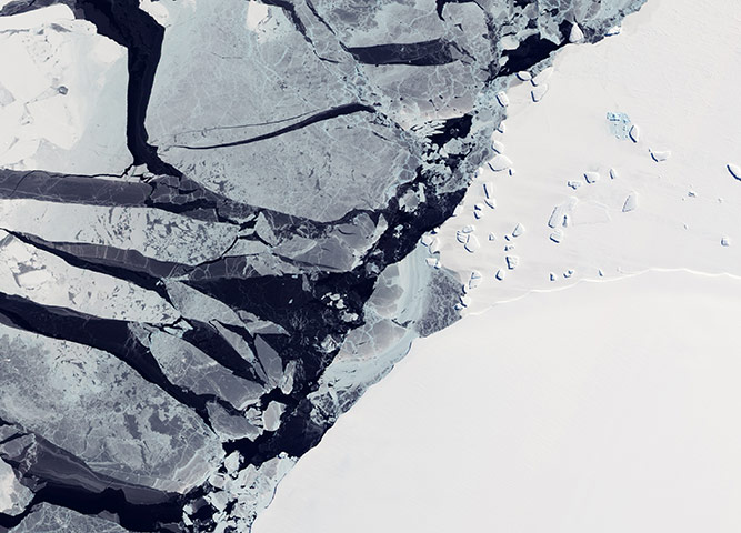
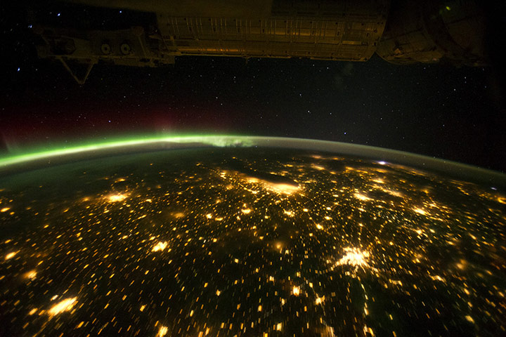
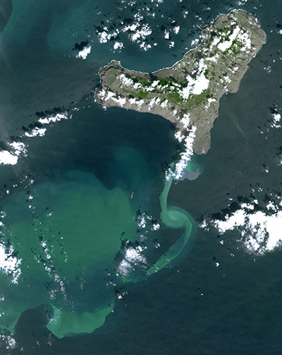
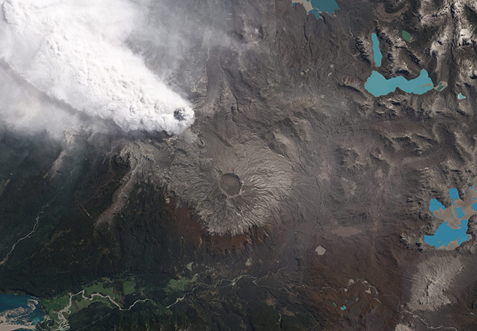
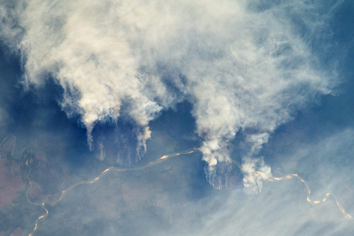
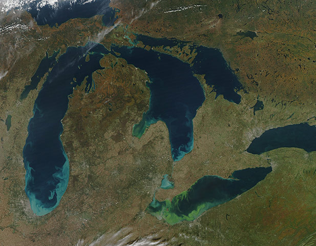
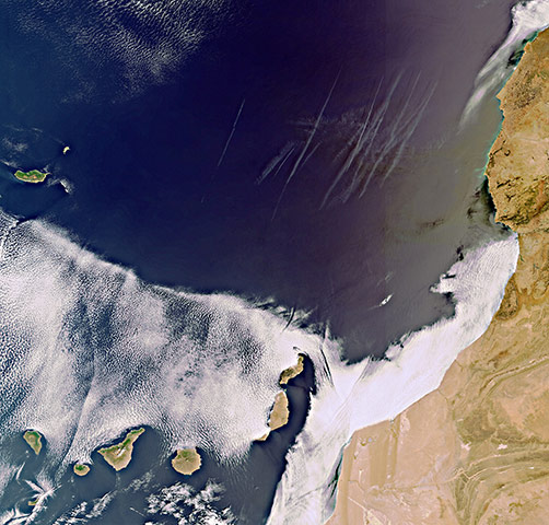
Though it is all composed of frozen water, ice is not uniform. On 7 October this image was taken of a variety of ice types off the coast of East Antarctica. Brilliant white ice fills the right half of this image. It is fast ice, and derives its name from the fact that it holds fast to the shore. This ice is thick enough to completely hiden the underlying seawater, hence its brilliant white colour. Trapped within the fast ice, and stuck along the edge of it, are icebergs. Ice shelves can range in thickness from tens to hundreds of meters, and the icebergs that calve off of them can tower over nearby sea ice. The water-saturated ice leaves a blue tinge. The icebergs along the edge of the fast ice are likely grounded on the shallow sea floor, and their presence may help hold the fast ice in place. Farther out to sea is pack ice that drifts with winds and currents. Much thinner than the fast ice, the translucent pack ice appears in shades of blue-greyPhotograph: ALI/E-O1/NASAThe night skies illuminated with light from many sources. For example, the midwestern United States has a night-time appearance not unlike a patchwork quilt when viewed from orbit. The artificial light from human settlements appears with a characteristic yellow tinge. The green light of the Aurora borealis also shines brightly in this view – even seeming to reflect off Earth’s surface in Canada. A small white patch of light is almost certainly lightning from a storm on the east coast (image top right). This photograph highlights the Chicago metropolitan area as the largest cluster of lights, next to the dark patch of Lake Michigan. The other largest metropolitan areas include St. Louis, Minneapolis-St. Paul, and the Omaha-Council Bluffs region on the Nebraska-Iowa border. The north-eastern seaboard lies just beyond the Appalachian mountains, a dark winding zone without major citiesPhotograph: ISS/NASAIn July 2011, volcanic tremors began on the Island of El Hierro in the Canary Islands, by September, many tourists evacuated the resort island, fearing a volcanic eruption. In early October, an underwater volcanic vent began erupting, sending ash and chemicals into the sea and causing muddy discolouration of the waters south of the island. Reports from a recent underwater survey by a Spanish research vessel revealed the presence of an eruptive vent and crater about 500 feet (150 metres) below the surface, accompanied by submarine 'pillow' lavas – pillow-shaped lavas that form underwater. The vent location was marked by brownish discolouration off the south tip of the island. Currents diluted and dispersed the volcanic material to the south and westPhotograph: ASTER/Terra/NASAThe eruption at Chile's Puyehue-Cordón Caulle continued in late October. The plume was much smaller than during the opening phases of the eruption (in early June), topping out at about 4.5km (2.8 miles). However, high atmospheric winds are carrying the ash away and disrupting air travel throughout the region. Depending on the wind, ash from Puyehue-Cordón Caulle is being carried as much as 120-250 km (75-160 miles) from the ventPhotograph: ALI/EO-1/NASASlash-and-burn forest clearing along the Rio Xingu (Xingu river) in the state of Mato Grosso, Brazil. This process has typically been achieved by clearing the forest using fire followed by planting of crops. The generally infertile soils of this rainforest – the largest such forest on Earth – make sustainable farming difficult. This drives people to convert more forest into farmland. The area of clearing can be considerable, and since the deforested regions are easily identifiable and measurable from space, the rate of deforestation is likewise easy to track. Light colored areas within the river channel are sand bars, which show that the river is in its annual low-flow/low-water stagePhotograph: ISS/NASAHaze fills the air over the coastal plain of eastern China on 7 October. A long band of haze, roughly 100km wide, extends east-west to the south-west of Beijing. South of Beijing, the haze fans out, extending from the shores of Bo Hai to the shores of the Yellow Sea. Along the shoreline, the haze is thick enough to obscure the coast. Agricultural fires (visible as red outlines in the high-resolution image) contribute to the haze, but it also results from urban and industrial pollutionPhotograph: MODIS/Aqua/NASAAnnual celebrations of the first European discoverers of America, 9 October is Leif Erikson Day, honouring the Viking (or Norse) explorer who sailed his crew to the first recorded landing of Europeans in North America around the year 1000. There is some evidence that a merchant named Bjarni Herjólfsson may have spotted North American lands around 985, after being blown off course on a voyage from Iceland to Greenland. Herjólfsson supposedly inspired Erikson with his account, provoking him to sail west from Greenland about 15 years later. According to Norse sagas, Erikson first spotted and landed in a 'land of the flat stones', or Helluland. That rocky, flat, barely vegetated land mass is now thought to be Baffin Island. Unsure of the prospects there, Erikson's expedition sailed south to what they called 'Markland', or 'the land of forests', likely along the Labrador coast of Canada. They eventually formed a settlement at Vinland in NewfoundlandPhotograph: NASAThe brilliant streaks of blue and green that color the Great Lakes in this image are a contradiction. The blue in Lake Michigan and Lake Huron is sediment brought to the surface when strong winds churned the lakes on 9 October 2011. The green in Lake Erie and in Lake Huron's Saginaw Bay is algae, which builds on the surface when winds are calm. Sediment most often colours the Great Lakes in the spring and fall when transitioning weather patterns bring storms and strong winds. The winds stir the water, pulling quartz sand and silt from the lake bottom to the surface. The white sand looks milky blue when viewed through the water from space. Some of the pale blue in Lake Erie may be sediment, but the green is an extremely large algal bloom. The bloom now covers much of the western half of the lake. Though satellite imagery cannot tell us what type of algae is growing, direct measurements of the water show that the bloom in Lake Erie is mostly a toxic algaePhotograph: MODIS/Aqua/NASABlack and white mosaic of images acquired on Thursday 1 September, showing massed camper vans and tents gathered for the desert-based Burning Man festival at Black Rock, NevadaPhotograph: Proba-1/ESANearly two months after being ignited by lightning, the Pagami Creek fire in northern Minnesota was nearly contained on 10 October. Since August 18, the fire has been burning in the Boundary Waters Canoe Area Wilderness in Superior National Forest. As of 11 October, the fire had burned 92,682 acres and was 82% contained. Apart from a faint hint of smoke, there is little sign of current fire activity in the image. The burned forest, however, is charcoal-coloured, in contrast to the green forest aroundPhotograph: Landsat-5/NASAOn 18 September 2011, a 6.9-magnitude earthquake struck the India-Nepal border region. According to news reports, impacts of the earthquake included landslides in the northern Indian state of Sikkim, between Nepal and Bhutan on 19 October 2011. Landslides look like giant scratches on the landscape, where dirt and rock have displaced vegetation. The avalanches of earth terminate in river valleys. In early October 2011, the geologist David Petley of the International Landslide Centre at Durham University noted that most of the landslides occurred on east- and south-facing slopes—away from the epicenter of the quake about 45 km (28 miles) to the northwest. As with most landslides occurring around earthquakes, researchers must ask whether those slides definitely resulted from the quakes – although other causes could not be ruled out, such as monsoon rainsPhotograph: ALI/EO-1/NASAThe subtropical Canary Islands off Africa's west coast are pictured in this image, acquired on 8 September 2011. To the north, multiple contrails can be seen over the dark blue water. To the east, the desert flatlands of Morocco and the Western Sahara are visible. The Portuguese archipelago, Madeira, lies to the north-westPhotograph: MERIS/Envisat/ESAThe Yukon river originates in British Columbia, Canada, and flows through Yukon Territory before entering Alaska. In south-western Alaska, the Yukon Delta spreads out in a vast tundra plain, where the Yukon and Kuskokwim Rivers meander toward the Bering Sea. Looking a little like branching and overlapping blood vessels, the rivers and streams flow through circuitous channels toward the sea, passing and feeding a multitude of coastal ponds and lakes. Over such low-lying, mostly treeless terrain, the rivers can change course frequently and carve new channels to find the fastest route toward the sea. The grassy plain provided not just a corridor for migrating wildlife, but also a home to the ancestors of today’s Native Americans. People have lived here for thousands of years, and the Yukon Delta is one of Alaska’s most populated rural areas, home to thousands of Yup’ik peoplePhotograph: Landsat/NASA
Sign up to read this article
Read news from 100’s of titles, curated specifically for you.