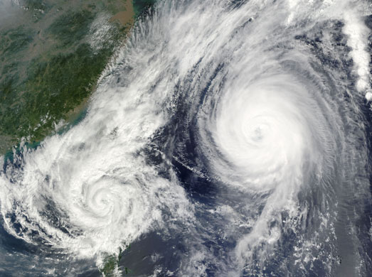
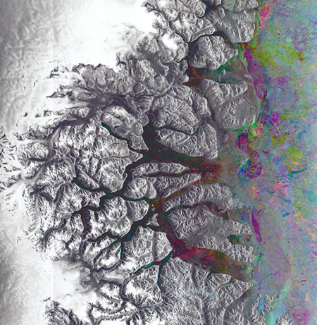
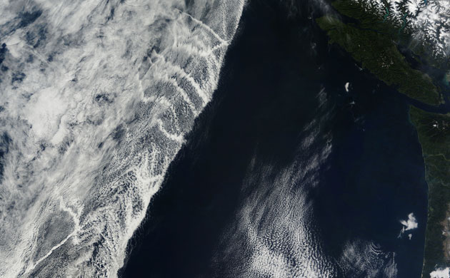
Once a powerful 'super typhoon', Parma crossed over the northern tip of Luzon Island, the Philippines, on 3 October 2009, as a category one typhoon. On 6 October, the storm reversed direction and moved south-east back over Luzon. The cause of this change in direction is shown in this true-colour image. Powerful super typhoon Melor moved close enough to Parma to influence its motion. When two cyclones approach one another, they can interact in a variety of ways. One interaction is the Fujiwara effect, in which the two storms are drawn together and begin to circle each other. In this case, Parma was drawn towards the stronger Melor. This image blends two satellite overpasses to show the proximity of the two storms to one another. The left half of the image, containing tropical storm Parma, was acquired at 10:35am Philippine time. The right half was taken just under two hours laterPhotograph: Terra and Aqua/MODIS/NASAThe Greenland Sea, a southern arm of the Arctic Ocean, is visible along the right side of this image. The south-easterly portion of the North-east Greenland national park, the world's largest and most northerly national park, is visible in white along the left. The colourful, narrow inlet (10-25km wide) visible near the bottom of the image is Kong Oscar fjordPhotograph: Envisat/ESAThey may look like airplane contrails, but the streaky clouds shown in this image formed around the exhaust left in the wake of ships traveling along the north-west coast of North America. This image was captured on 5 October 2009. All clouds form when water molecules coalesce onto tiny particles in the atmosphere. The particles can be natural things like dust or sea salt, but they can also be aerosols emitted by human activity. With only the water's surface to influence it, air over the ocean tends to be uniform, often resulting in flat sheets of clouds that cover a wide area. When ships introduce new particles into the air by pumping out a stream of exhaust, water molecules readily cling to the particles, creating long clouds called ship tracks that trail behind a shipPhotograph: Terra?modis/NASA
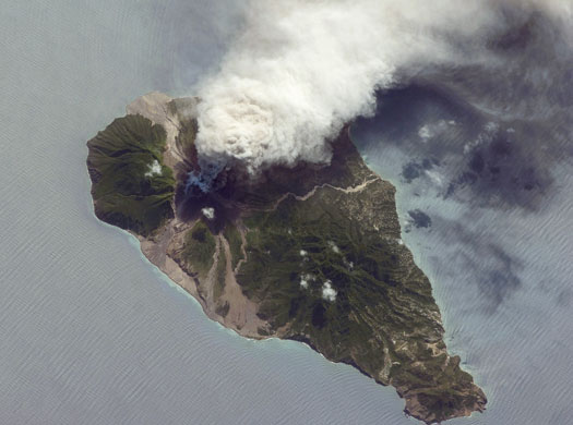
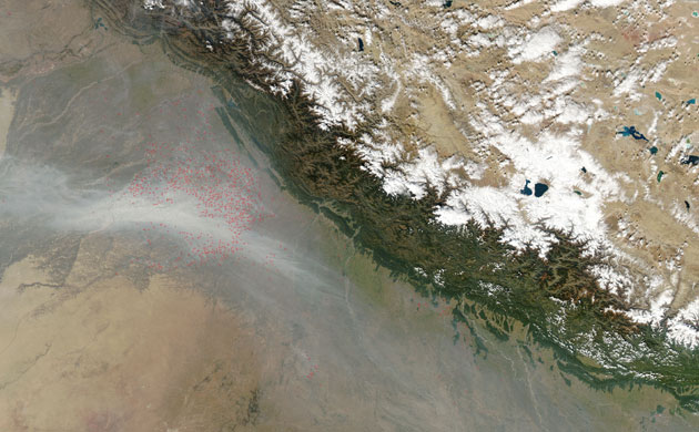
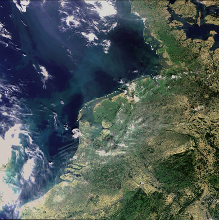
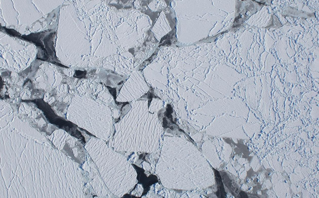
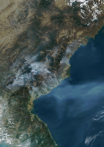
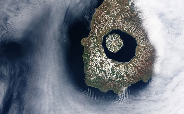
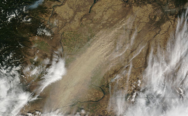
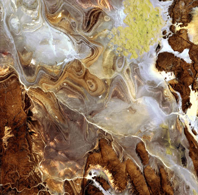
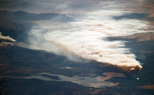
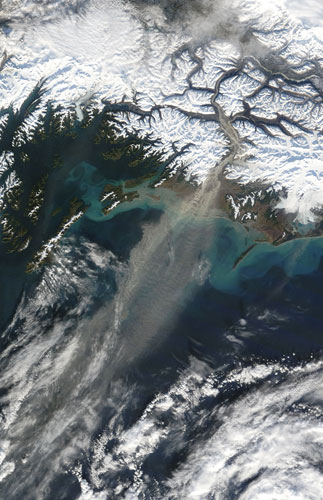
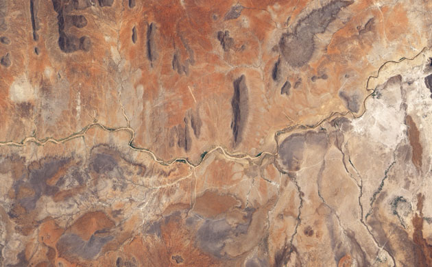
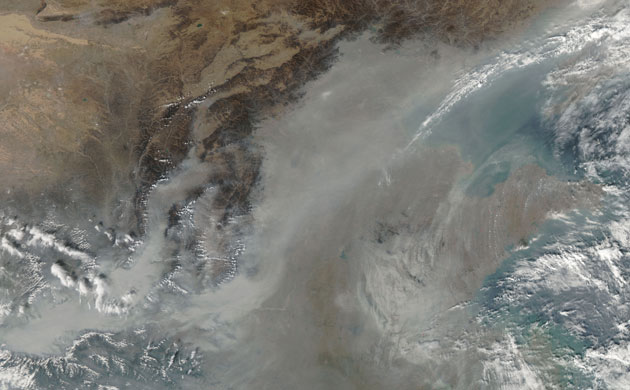
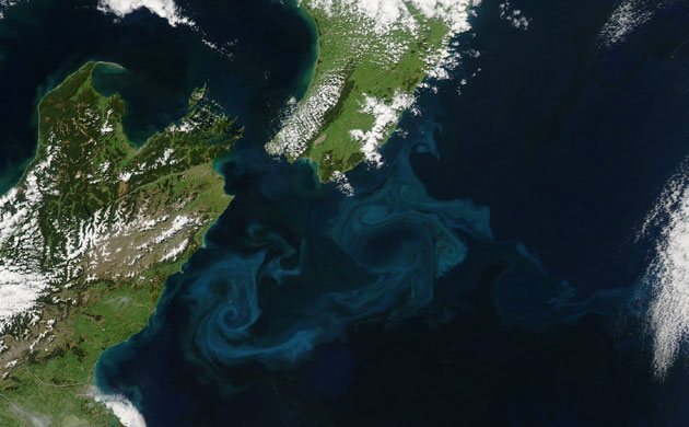
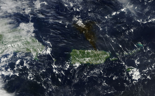
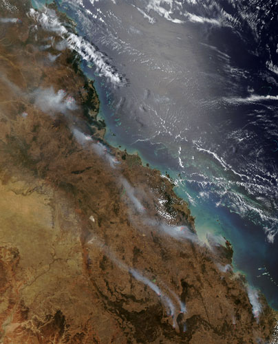
The Soufriere Hills, a volcano on the island of Montserrat, in the Lesser Antilles island chain in the Caribbean Sea, has been active since 1995. The most recent eruptive phase of the volcano began with a short swarm of volcano-tectonic earthquakes thought to be caused by movement of magma beneath a volcano on 4 October 2009, followed by a series of ash-venting events that have continued through October. These venting events create plumes that can deposit ash at significant distances from the volcano. The silver-grey appearance of the Caribbean Sea surface is due to sun glint, which is the mirror-like reflection of sunlight off the water surfacePhotograph: ISS/NASAThe Great Bitter Lake is one of several lakes located along the Suez Canal, which connects the eastern Mediterranean and Red Seas. As the canal is built only to allow ships to travel in a single lane, the Great Bitter Lake is a location where ships can change their position in line before proceeding to either Port Said to the north, or the port of Suez to the south. The lake also provides an intermediate harbour for ships traversing the Canal, a journey that typically takes 14 hours end to end. Several ships, some under power and some anchored, are visible in the right of this image. The town of Fayid (also spelled as Fayed), visible along the western shore of the lake (bottom of image) is a tourist destination for residents of Cairo, particularly in the summer monthsPhotograph: ISS/NASAThe skies over north-west India were extremely hazy on 1 November, 2009. Scores of fires (locations outlined in red), probably related to agriculture, were puffing small plumes of smoke that coalesced into a thick river of haze to the south. The haze may also contain urban air pollution and dustPhotograph: Aqua/MODIS/NASAThis image captures the dynamic landscape of the Wadden Sea, a tidal wetlands area in the south-eastern part of the North Sea that extends some 450km along the coasts of the Netherlands, Germany and DenmarkPhotograph: Envisat/ESAOn 16 October, Operation Ice Bridge researchers and crew completed the first flight of the Antarctic campaign. The flight was made from the southern tip of South America and its primary target was the Getz Ice Shelf along Antarctica's Amundsen Coast. During the flight along Amundsen Coast, the aircraft's downward-looking digital mapping system camera captured this image of sea ice from an altitude of at least 20,000 feet. The DC-8 aircraft flew two parallel tracks along the coast, one just offshore over the floating ice shelf, and one just inland. By measuring on either side of the 'grounding line' between the floating ice and the ice on land, scientists can determine the rate at which this near-shore part of the ice shelf is meltingPhotograph: NASAMultiple fires burned in North Korea in mid-October 2009, sending a plume of smoke over the Sea of Japan. Red outlines indicate hotspots associated with active fires. The smoke plumes blow uniformly eastward, some of the individual plumes coalescing into a single large plume over the seaPhotograph: Aqua/MODIS/NASAMore than 9,000 years ago, a catastrophic volcanic eruption created a huge caldera on the southern end of Onekotan Island, one of the Kuril Islands, located off the southern tip of Russia's Kamchatka peninsula. Today, the ancient Tao-Rusyr caldera is filled by the deep blue waters of Kal'tsevoe Lake. In the north-west section of the caldera is Krenitzyn Peak, which rises to a height of 1,325m (4,347ft). Like the other Kuril Islands, Onekotan lies along the Pacific 'ring of fire'. The Kuril Island volcanoes are fueled by magma generated by the subduction of the Pacific plate under the Eurasian plate, which takes place along a deep trench about 200km (120 miles) to the east. The only historical eruption at Krenitzyn Peak occurred in 1952, a week after a magnitude 9.0 earthquake along the subduction faultPhotograph: EO-1/NASAVisibility dropped to zero in parts of eastern Washington on 4 October 2009, as a large dust storm blew through. According to local news, the storm brought strong winds gusting to 43mph in places that propelled the dust across the south-east corner of the state. A thick, rippling plume of dust runs north-east to south-west through the centre of this image. Dust stretches as far south as the cities of Pasco and Kennewick, which sit on opposite banks of the Columbia River. In the north, the dust seems to rise primarily from the pale golden squares of fields farmed using dryland agriculture, a common practice in arid eastern Washington. The dryland fields are larger and less colourful than the bright green and gold fields of irrigated agriculture near the Columbia and Snake Rivers in the center of the imagePhotograph: Terra/MODIS/NASAThe image shows the extraordinary landscape of the Tanezrouft basin, one of the most desolate parts of the Sahara desert, in south-central Algeria. The region is known as 'land of terror' because of its lack of water and vegetation. As visible, this region is characterised by dark sandstone hills, steep canyon walls, salt flats (white), stone plateaus, sandstone outcrop patterns of concentric loops and sprawling seas of multi-storey sand dunes known as 'ergs'. Erg Mehedjibat, which appears as a yellow patch (upper right), is made up of a cluster of small star dunes that grow upward rather than laterallyPhotograph: ALOS/ESAThe late summer-autumn wildfire season is in full swing in the western United States. Significant wildfires are observed each year by astronauts orbiting the Earth on the International Space Station. This astronaut photograph shows the Arnica fire in Yellowstone national park. The fire was started by a lightning strike and warm, dry and windy conditions provided a favourable environment for growth of the fire, which was estimated to be 3,764 hectares (9,300 acres) in size. Landmarks visible in the image include Yellowstone and Jackson Lakes at image center; the Teton Range is visible in the background. The reflection of the smoke plume is visible in Yellowstone LakePhotograph: ISS/NASARising from the Copper glacier, Alaska's Copper River flows through a glacier-carved landscape of steep mountains and fields of sand dunes before emptying into the Gulf of Alaska. The river is choked with silt and lined with sand. It is also prone to high winds. In this image, from 30 October 2009, the wind is blowing from the snow-covered mountains to the Gulf of Alaska. The wind picked up fine sediment from the riverbank and carried it over the ocean. The pale brown plume of airborne dust contrasts sharply with the dark ocean beneath it. The sand and silt come from the combined erosive power of flowing ice and water. Heavy glaciers grind rock into fine sediment and gravel as they flow slowly down mountain valleys. The sediment washes into rivers and streams, and much of it eventually makes its way to the Copper River. The flowing water of the river also erodes away rock, adding to the accumulation of sediment from glaciersPhotograph: Terra/MODIS/NASAThe Ewaso Nyiro River flows down from Mount Kenya to water the dry plains that stretch east from the Great Rift Valley in Kenya. The sparsely populated plains are a haven for wildlife, which rely on the river as a source of water. Multiple public and private wildlife reserves, including Samburu national reserve and Buffalo Springs national reserve, line the banks of the river. In 2009, the river wasted and then went dry as the region sank into severe drought. The dry river bed is exposed herePhotograph: EO-1/NASAThick haze and fog settled over much of China on 28 October, 2009. The thickest of the grey-brown haze conforms to the low-lying contours of the Yellow River Valley and the western half of the North China plain near the Luliang mountains. A temperature inversion may be responsible for the build-up of pollution over eastern China. Normally, air cools with altitude, but occasionally, a layer of cool air will be trapped beneath a layer of warm air. Since the cool air is more dense than the air above it, the two layers don't mix and pollutants build up in the cool air near Earth's surface. Temperature inversions develop most often during the winter, when long, cool nights chill the ground. The cold land cools the air nearest the ground, leaving the air at higher altitudes warmer. The two layers of air do not easily mix, and the temperature inversion can last for days if winds are calmPhotograph: Aqua/MODIS/NASAOff the east coast of New Zealand, cold rivers of water that have branched off from the Antarctic circumpolar current flow north past the South Island and converge with warmer waters flowing south past the North Island. The surface waters of this meeting place are New Zealand's most biologically productive. This image of the area on 25 October, 2009 shows the basis for that productivity: large blooms of plantlike organisms called phytoplankton. In addition to their importance as the foundation of the ocean food web, phytoplankton play a key role in the climate because, like plants on land, they absorb carbon dioxide from the atmosphere. When they die, they sink to the ocean floor where the carbon they took from the atmosphere is stored for thousands of yearsPhotograph: Aqua/MODIS/NASAOn the morning of 23 October, 2009, an explosion rocked fuel storage tank facilities near San Juan, Puerto Rico, with the same force as a 2.8-magnitude earthquake, according to CNN. Authorities evacuated hundreds from the area, and firefighters battled blazes for two days. Although most of Puerto Rico appears green, the fire occurs in a gray-beige area of urbanisation, the San Juan metropolitan area. According to Reuters, the fire broke out in Cata–o, which lies across a small bay from San Juan. Although smoke from burning vegetation is typically grey, this smoke is almost dark enough to disappear against the background of deep blue ocean waterPhotograph: Terra/MODIS/NASAFires burned along the coast of Queensland, Australia on 17 October, 2009. The Modis on the Aqua satellite captured this image the same day. Red outlines indicate hotspots associated with actively burning fires. Thick plumes of smoke blow away from the fires predominantly toward the north-west, although two large clusters of fires west-southwest of Cairns send their smoke toward the south-westPhotograph: Aqua/MODIS/NASA
Sign up to read this article
Read news from 100’s of titles, curated specifically for you.


.jpg?w=600)