Satellite eye on Earth: November and December 2013 – in pictures
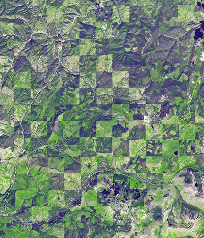
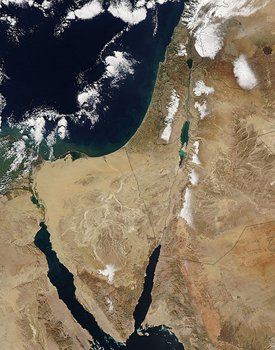
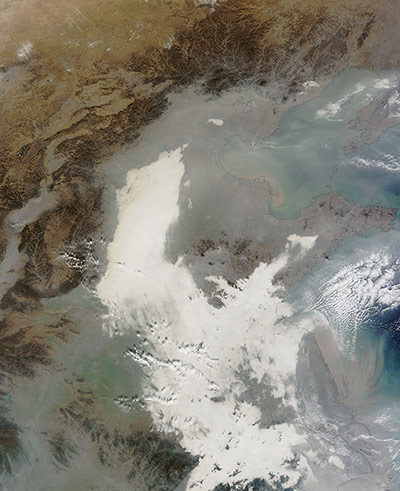
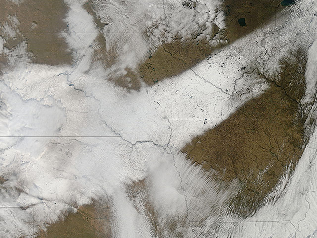
Logging chequers the landscape along the Idaho-Montana border, sandwiched between Clearwater and Bitterroot national forests. The area is harvested at different times, producing a pattern of varied timber density and re-growth stagesPhotograph: ASTER/NASAA rare winter storm brought cold temperatures, wind, rain and snow to the Middle East. On 16 December, three days after the storm ended, snow still clung to the higher elevations of Syria, Egypt, Lebanon, Israel and the West Bank, and Jordan. The storm dumped upto 50 cm of snow in Jerusalem and 45 cm in Amman, Jordan, while Cairo experienced its first snowfall in 112 years. The region also got torrential rainfall and severe flooding. At least 40,000 people were evacuated from flooded areas in Gaza. And hundreds of thousands of refugees in Syria faced life-threatening conditions as thick snow covered their tents in plunging temperatures Photograph: MODIS/Terra/NASASmog shrouds eastern China as another severe bout of air pollution produced thick haze stretching from Beijing to Shanghai, a distance of about 750 miles (12,000km). The brightest areas are clouds or fog. Polluted air appears grey. While northeastern China often faces outbreaks of extreme smog, it is less common for pollution to spread so far south. At the time of the satellite image, the air quality index reached 487 in Beijing and 404 in Shanghai. An AQI above 300 is considered hazardous to all humansPhotograph: MODIS/Terra/NASA
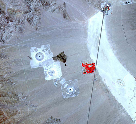
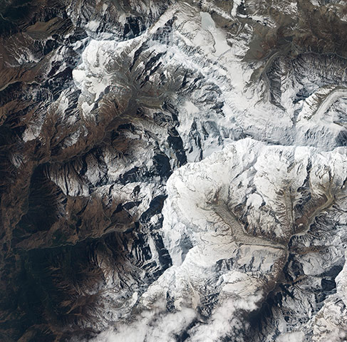
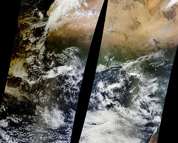
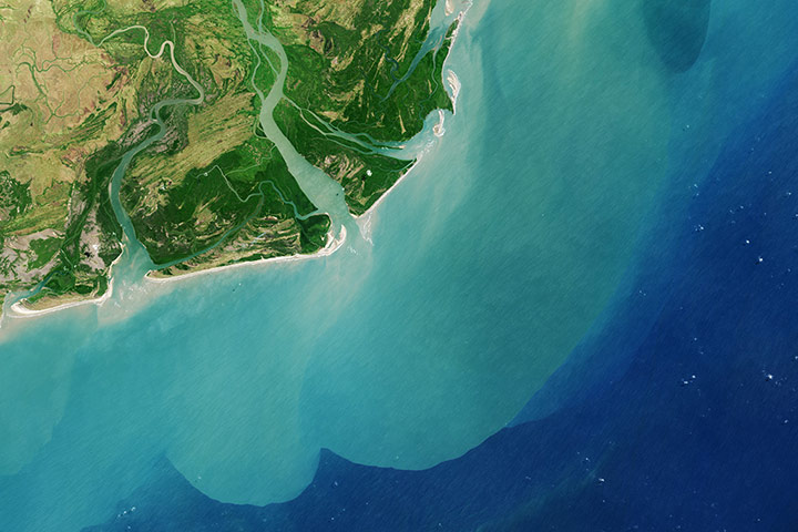
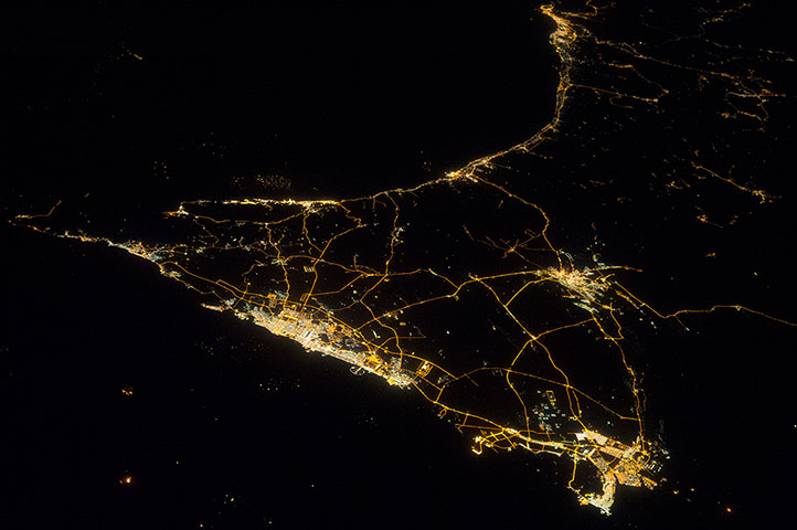
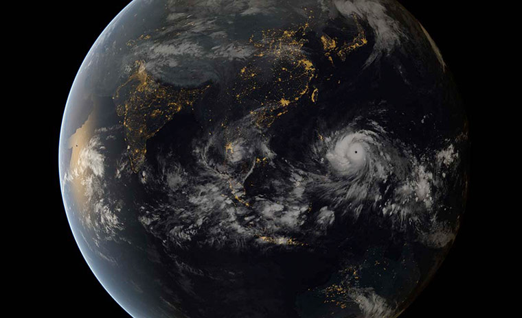
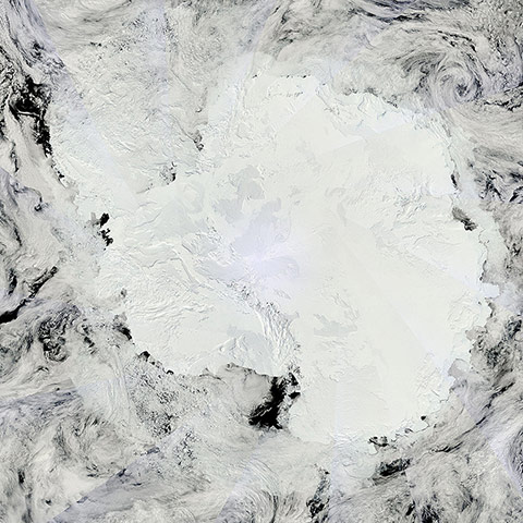
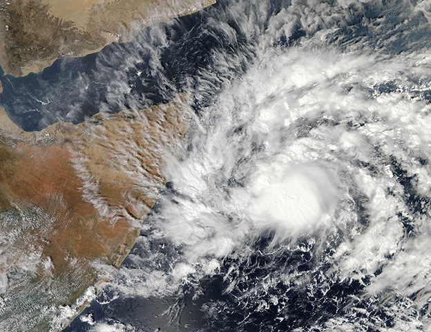
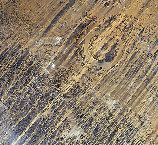
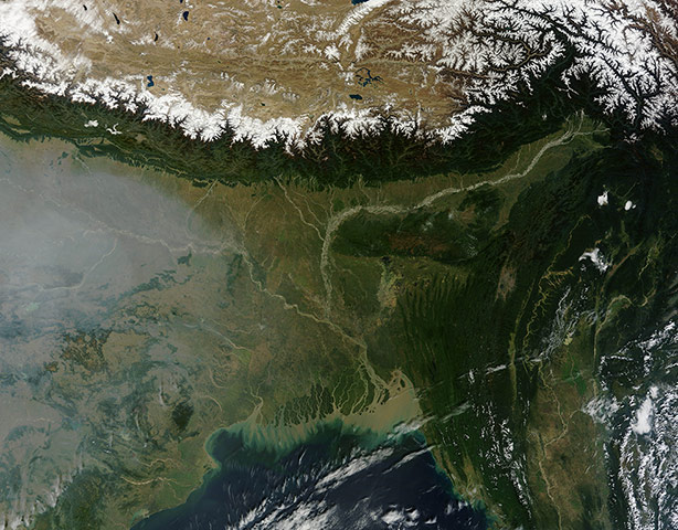
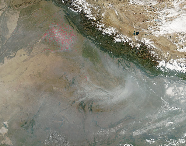
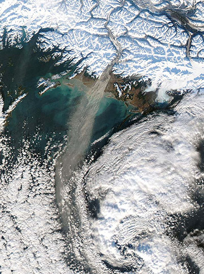
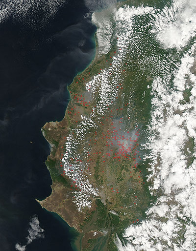
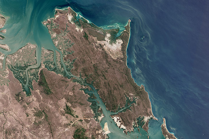
The largest solar plant of its kind in the world in southern California's Mojave Desert, near the Nevada border, uses 170,000 mirrors to focus the sun's heat on giant boilers atop 120m concrete towers, where water is turned into steam to power turbines that generate electricity. The 392 MW plant has started producing power. It will generate enough electricity to power 140,000 homes Photograph: ASTER/NASAThe Annapurna is only the 10th tallest mountain in the world, but it ranks as one of the most dangerous. The mountain is in Nepal along a 34-mile (55km) ridge, east of the Gandaki River, which has carved one of the deepest river gorges in the world. The gorge separates Annapurna from Dhaulagiri, the seventh tallest mountain in the world. The rocks that make up Annapurna’s summit—limestone formed at the bottom of a warm ocean—are a reminder of the powerful tectonic forces that pushed up the world’s highest mountains. Other mountains with limestone near the summits include the Everest and Dhaulagiri. Only 191 people have successfully ascended Annapurna, fewer than any other similar mountain. Annapurna's fatality rate of 32% makes it the deadliest of all mountainsPhotograph: NASAThe last eclipse of 2013 was a rare event: a 'hybrid' solar eclipse. At sunrise the moon blocked just part of the sun (an annular eclipse) as the event began over the western Atlantic Ocean, then transitioned to a full solar eclipse along a narrow path of totality in the far eastern Atlantic and over parts of Africa. For just over three hours, the shadow of the moon traced a path about 8,451-mile long, but only 36-mile wide at its maximum extent. Seven of the five-minute swaths over western Africa have been sewn together in this mosaic. In this image, where the moon passes in front of the sun, and shadows the Earth, the surface of the Earth appears black (left edge of the image). This event was especially unusual because the eclipse shifted from partial to annular to total, and then ended. The last hybrid eclipse was reported to have occurred on 20 November 1854 and the next is expected on 17 October 2172Photograph: MODIS/Terra/NASAZambezi River Delta drains a watershed that spans eight countries and nearly 600,000 sq miles. The Zambezi is the fourth largest river in Africa, and the largest east-flowing waterway. From headwaters in Zambia, it rolls across 1,599 miles of the south-central African plateau before pouring water and sediment into the Indian Ocean through a vast delta in MozambiquePhotograph: OLI/Landsat 8/NASAUnited Arab Emirates at night: the largest cluster of lights is the 'joined-cities' of Dubai-Sharjah-Ajman, with smaller neighbour Abu Dhabi. These cities sit on the Persian Gulf (also known as the Arabian Gulf). The lights cut off abruptly at the coastline. The bright city centres are located at the coast, indicating that sea trade has been important to the growth of these cities. Major highways join the cities in a brightly lit network, and a faint peppering of lights offshore shows the oil and gas platforms on either side of the Musandam Peninsula (left on the image). Muscat, the capital city of neighbouring Oman, appears at top centre of the image Photograph: ISS/NASAAn autumn storm brought the first snow of the season to the Upper Mississippi River Valley and the midwestern United States on 6 November, just as the storm was clearing. A long band of snow stretching from Colorado in the southwest to Wisconsin in the northeast marked the path of the blowing stormPhotograph: MODIS/Terra/NASAA digital composite of typhoon Haiyan approaching the Philippines, made using images captured by the geostationary satellites of the Japan Meteorological Agency and Eumetsat on 7 November. This satellite image shows the fearsome size of typhoon Haiyan as it heads towards the Philippines, where it wrecked havoc, killing scores of people and wiping out entire villages Photograph: Japan Meteorological Agency and EUMETSAT/NASAA true-colour mosaic of Antarctica, the coldest, driest and windiest place on Earth – and, during the austral summer, it is also the sunniest. Due to the tilt of the Earth’s axis in relation of the sun, the frozen land south of the Antarctic Circle receives six months of daylight in summer, and six months of darkness in winter. The long hours of sunshine allow for excellent imagery of the region from space. As the Terra satellite is in a polar orbit, it passes over each pole approximately 14 times a day, and acquires an image on each pass. To create a mosaic, the data that are closest to the center of each swath – where edge distortion is minimised – are used to create a complete view of the region. The Modis Rapid Response system generates complete mosaic images of Antarctica every day in austral late spring, summer and early fallPhotograph: MODIS/NASAJust days after typhoon Haiyan devastated the Philippines, Somalia also suffered a rare and deadly tropical cyclone. It formed in the Arabian Sea and slowly moved westward to make landfall in northeastern Somalia on 11 November 11. It dropped 100-200 mm of rain over the region, with some areas in Puntland reporting 350 mm. The rain caused flash floods, which destroyed hundreds of houses and washed thousands of livestock out to sea. At least 143 people died Photograph: MODIS/Aqua/NASAThe Aorounga crater in northern Chad is just south of the Tibesti mountains, a range of inactive – with some potentially active – volcanoes in the central Sahara desert...Measuring about 8 mile across, the crater was created by a meteorite impact about 340 million years ago. Clearly visible is the dark, central peak, caused by material splashing up after the impact, similar to how water bounces back up when a stone is thrown in. This peak is surrounded by a low, sand-filled ring, which is surrounded by another ring of rock from when the material was thrown outwards. A distinctive low, sand-filled trough circles the others – the outer edges of the initial impact. The linear rock ridges that run diagonally across this image are ‘yardangs’ and are formed by wind erosion. Here, we can clearly see how the wind blows from northeast to southwest. Sand dunes form in the wind-cut valleys between the rock ridges of the yardangsPhotograph: AXA/ESASweeping from west to east across the image are the snow-covered peaks of the Himalayas. Meaning 'abode of the snow' in Sanskrit, the Himalayas stretch about 1,500 miles (2,400km) across India, Pakistan, Afghanistan, China, Bhutan and Nepal, and separate the Tibetan Plateau in the north from the more fertile plains to the south. The Himalayas are the third largest deposit of snow and ice in the world, following Antarctica and the Arctic, and are home to about 15,000 glaciers. These snowy peaks are also the sources of many major rivers, including the many tributaries of the Ganges, which can be seen running nearly parallel to the mountains in India, where the river valley is veiled with a cloud of smoke, haze and pollution. The mountain snow and glaciers also give rise to the Brahmaputra River, which runs roughly parallel to the mountains in the east. These rivers join in Bangladesh, forming the Ganges Delta. Muddy waters flow from the delta into the Bay of BengalPhotograph: MODIS/Terra/NASAFires continued to burn in northwest India through early November. Hundreds of fires, marked by red dots, cluster in the Punjab region. Smoke plumes point southeastward, blown by strong winds. Smoke from the fires travels along the face of the Himalaya mountains, and collects in the valley to the south, where the highly irritating smoke joins pollutants from cities and industry to create a heavy haze which often hangs over the region. Such fire clusters are typical in this region in October and November, and are primarily agricultural in origin. They are deliberately set to manage cropland, in order to clear old crops and to improve the land for the next planting cyclePhotograph: MODIS/Aqua/NASADust storm in Alaska: when glaciers grind against underlying bedrock, they produce a silty powder with grains finer than sand. Geologists call it 'glacial flour' or 'rock flour.' This iron- and feldspar-rich substance often finds its ways into rivers and lakes, coloring the water brown, grey, or aqua. When river or lake levels are low, the flour accumulates on drying riverbanks and deltas, leaving raw material for winds to lift into the air and create plumes of dust. Scientists are monitoring Arctic dust for a number of reasons. Dust storms can reduce visibility enough to disrupt air travel, and they can pose health hazards to people on the ground. Dust is also a key source of iron for phytoplankton in regional waters. Finally, there is the possibility that dust events are becoming more frequent and severe due to receding glaciers in coastal AlaskaPhotograph: Aqua/MODIS/NASADozens of red hotspots mark fires burning in western Ecuador on 2 December. The fires in this image are most likely agricultural in nature. The location, widespread nature, and number of fires suggest that these fires were deliberately set to manage land. Farmers often use fire to return nutrients to the soil and to clear the ground of unwanted plants. While fire helps enhance crops and grasses for pasture, they also produce smoke that degrades air quality. Actively burning areas are outlined in redPhotograph: MODIS/Aqua/NASACurtis Island lies just off Australia’s central Queensland coast, straddling the Tropic of Capricorn. The varied landscapes, wetlands, and waters support large fisheries, the endangered green and loggerhead turtles, the fatback turtle, dolphins, and the yellow chat—a bird once thought to be extinct. The eastern half of the island is largely protected as part of Curtis Island national park and conservation park. The island can only be accessed by sea or air, making it somewhat remote. To the island’s southwest, a natural deepwater harbour named Port Curtis supports major industrial port cities on the mainland, where they process coal, aluminum, and liquefied natural gas for export. The footprint of three large LNG processing facilities is visible. Billions of dollars have been invested to tap Queenland’s natural gas supply, including the recent approval of a gas transmission pipeline to Curtis IslandPhotograph: OLI Landsat 8/NASA
Sign up to read this article
Read news from 100’s of titles, curated specifically for you.