Satellite eye on Earth: November 2012 – in pictures
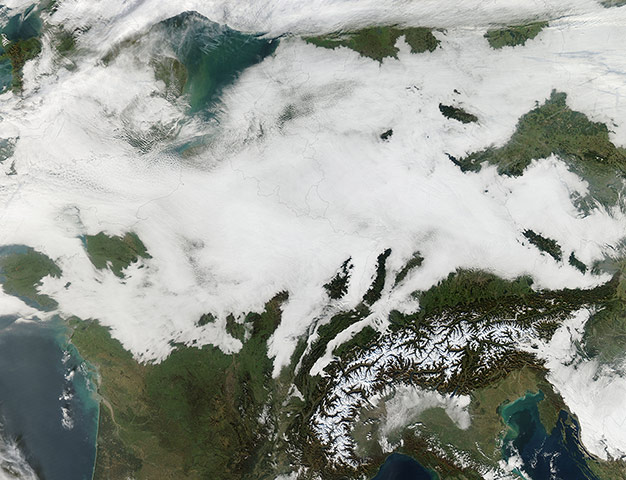
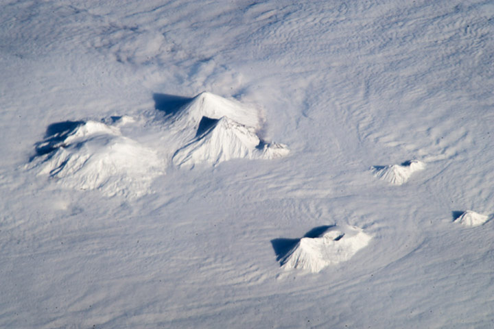
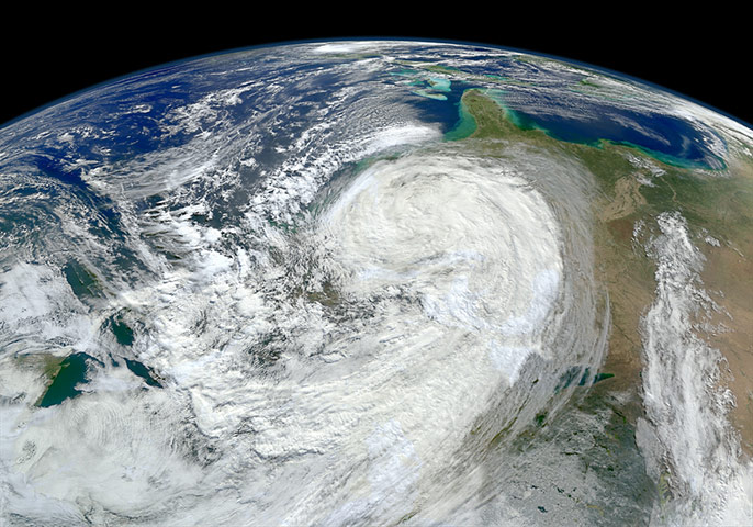
An immense band of low clouds covered most of central Europe on 15 November. At that time low clouds stretched from the French Alps in the south to the North Sea, and from the Irish Sea in the west to Belarus in the east. According to the BBC, Heathrow airport in London, England cancelled 78 services while London City airport cancelled at least 20 flights through the day. The Woolwich Ferry service in London was also suspended during the morning. Fog is simply clouds formed at ground level. Sunlight typically warms the air and burns off fog, but as autumn advances and nights lengthen, fog becomes more common, especially in low-lying valleys. If unperturbed by winds, such fog can persist for daysPhotograph: MODIS/Aqua/NASAWhile this image may look like it was taken from a passenger airplane, in fact it was taken from the considerably higher altitude of the International Space Station. The snow-covered peaks of several volcanoes on the central Kamchatka Peninsula stand above a fairly uniform cloud deck that obscures the surrounding lowlands. In addition to the rippled cloud patterns – caused by interactions of air currents and the volcanoes – a steam and ash plume is visible extending north-northeast from the relatively low summit (2,882 meters above sea level) of Bezymianny volcanoPhotograph: ISS/NASAAs the large Hurricane Sandy moved north along the US east coast, the waves it generated churned up sediments from the continental shelf and left turbid water in its wake. Meanwhile, the remnants of the storm were battering the north-eastern statesPhotograph: VIIRS/Suomi NPP/NASA
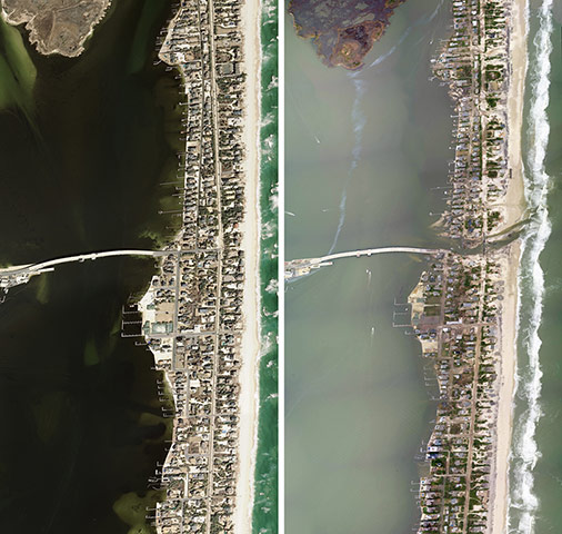
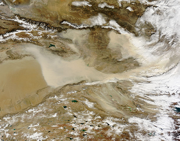
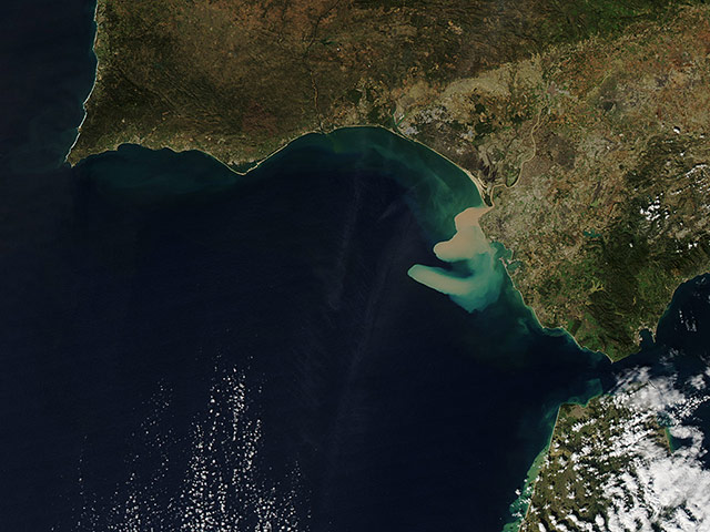
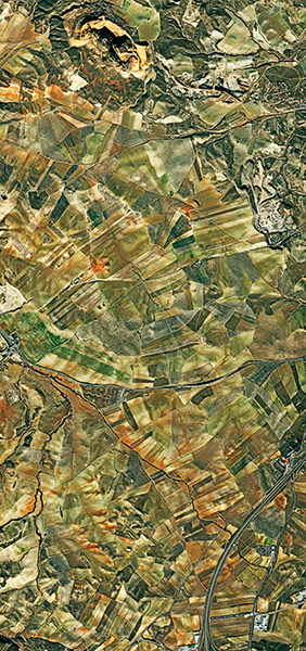
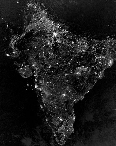
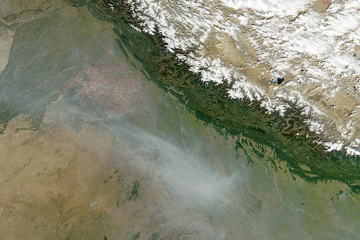
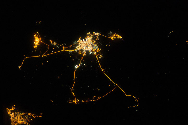
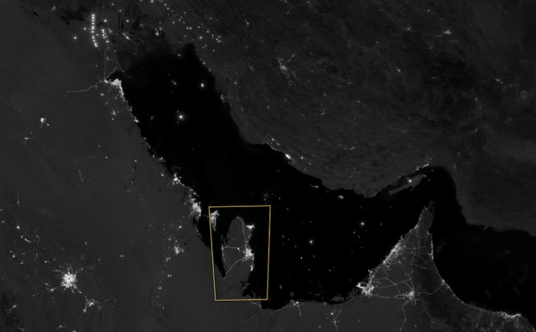
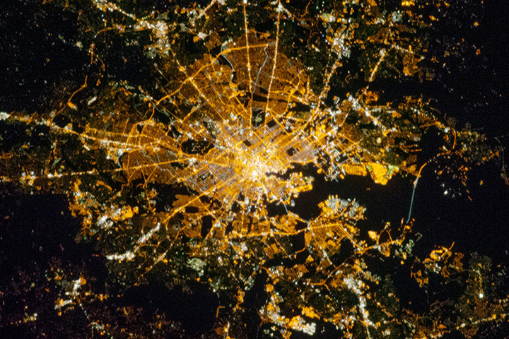
The two aerial photographs above show a portion of the New Jersey coastal town of Mantoloking, just north of where Hurricane Sandy made landfall: right on 31 October 2012; left on 18 March 2007. The Mantoloking Bridge cost roughly $25m when it was opened in 2005 to replace a bridge built in 1938. After Sandy passed through on 29 October 2012, the bridge was covered in water, sand, and debris from houses; county officials closed it because they considered it unstable. On the barrier island, entire blocks of houses along Route 35 (also called Ocean Boulevard) were damaged or completely washed away by the storm surge and windPhotograph: NOAA/NASAChina's largest, hottest, and driest desert sits in the westernmost part of the country. Filling the Tarim Basin, the Taklimakan (also Taklamakan) Desert is cut off from the impacts of the Asian monsoon and Arctic storms that bring moisture to other parts of the region. Shifting sand dunes cover about 85% of the desert floor, some of the dunes rising to a height of 200 meters. Winds can easily loft the sand into the air, carrying it eastward over China. Part of the Taklimakan Desert inside the Tarim Basin appears along the left edge of the image. Dust plumes, thick enough in places to completely hide the land surface below, blow away from the basin's eastern marginPhotograph: MODIS/Terra/NASAThe Guadalquivir River empties into the Golfo de Cádiz (Gulf of Cádiz) along Spain’s south-western coast. In November 2012, the river delivered a heavy load of sediment to the gulf. Thick sediment gave the Guadalquivir River a tan hue, and that same color dominated the water near the river delta. Sediment does not continuously colour the Golfo de Cádiz. But the Guadalquivir River prodelta – the submerged portion of the delta that lies beyond the delta front – is rich in fine-grained mud. One would think that a sediment plume released into the ocean would simply fan out evenly in all directions, but the shape of this sediment plume is convoluted. The shape may be the result of complicated ocean currentsPhotograph: MODIS/Aqua/NASAThe fertile land of southern Spain’s Granada province is shown in this image from the Pleiades satellite. In the lower right, we can see a highway that leads north towards the the provincial capital, Granada. Along that road, the red roof and pool of a motel and campground are visible. Staying in the lower right, what appears to be a large car park is a scrap yard. At the top of the image is Montevive, a hill that had been a site for mining minerals such as strontiumPhotograph: MERIS/Envisat/ESAEvery autumn, Hindus around the world light lamps, candles, and firecrackers as part of a five-day festival known as Diwali. The celebration, which has roots as a harvest festival, usually falls between mid-October and mid-November. In 2012, it began on 11 November. This is a nighttime view of southern Asia on 12 November. Most of the bright areas are cities and towns in India, the country with the world’s largest Hindu population. India is home to more than 1.2 billion people and has 30 cities with populations over 1 million. (For comparison, China has 62 cities with more than 1 million residents and the United States has nine). Cities in Bangladesh, Nepal, and Pakistan are also visible near the edges of the imagePhotograph: VIIRS/Suomi NPP/NASAHundreds of fires continued to burn in north-west India on 28 October. Most of the fires are located in the agricultural Punjab region, but a few are also located in Pakistan, to the west, and a few more spot the agricultural land east of the Punjab region. Smoke from these fires contributes to the heavy haze hanging over the land. This cluster of fires is a common sight from space each year in October and November. They appear in an agricultural region where October brings the end of the Kharif crop (autumn crop) and the beginning of the Rabi crop (spring crop). As the season changes, farmers often use fire to clear the fields after harvest in order to ready the land for new plantingPhotograph: MODIS/Aqua/NASAThe Tibesti Mountains, located mostly in Chad with the northern slopes extending into Libya. The mountains’ highest peak is Emi Koussi – pictured here as a circular structure in the lower-right portion of the dark area. The westernmost volcano is Toussidé. The satellite view shows the dark peak with lava flows extending to the left. The white depression to the southeast gets its colour from the accumulation of carbonate salts, creating a soda lake. Surrounding the Tibesti Mountains, the sands of the Sahara appear like orange, yellow and white brushstrokesPhotograph: MERIS/Envisat/ESACloud streets amid northwesterly winds over Hudson Bay on 13 November. Cloud streets, long parallel bands of cumulus clouds, form when cold air blows over warmer waters, while a warmer air layer (or temperature inversion) rests over the top of both. The comparatively warm water gives up heat and moisture to the cold air above, and columns of heated air called thermals naturally rise through the atmosphere. The temperature inversion acts like a lid. When the rising thermals hit it, they roll over and loop back on themselves, creating parallel cylinders of rotating air. As this happens, the moisture in the warm air cools and condenses into flat-bottomed, fluffy-topped cumulus clouds that line up parallel to the prevailing wind. Cloud streets can stretch for hundreds of kilometres if the land or water surface underneath is uniformPhotograph: MODIS/Terra/NASANight lights can reveal a lot about the distribution of people on the landscape. The lights of Qatar show informative demographic detail that is very difficult to discern in daylight images – especially in deserts, where even large cities can be hard to see. The brightest group of lights at image center is the capital city, Doha, with the neighboring smaller ports of Ad-Dahira and Umm Sa’id to the north and south. (Note that north is to the left). Highways are clearly visible leading west from the capital to the Dukhan oil fields, to Saudi Arabia, and to the north of the country where – judging by the lack of night lights – the population is probably very low. The relatively minor coast road between the oil fields and the Saudi frontier also stands outPhotograph: ISS/NASAWhile some night views are informative about a landscape, they can also be difficult and confusing to locate. Astronauts learn to recognise where they are at night by flying over populated places repeatedly. Coastlines – one of their best geographic indicators – are generally lost to view because water surfaces and unpopulated land surfaces look the same without illumination such the full moon. The thumb-shaped Qatari peninsula, so well-known in Middle Eastern geography, does not show up at all in this nighttime photograph. However, the low-light imaging bands of the visible infrared imaging radiometer suite on the Suomi NPP satellite showed the Qatari peninsula and the long arm of the Gulf of Bahrain (lower image) on a moonlit nightPhotograph: VIIRS/Suomi NPP /NASASt Helena is a small, rugged volcanic island in the southern Atlantic Ocean. At its highest point, Mount Actaeon, the island rises 818 meters above sea level – high enough to affect cloud formation. On 15 November 2012, cloud vortices stretched away from the island to the west-northwest. When moving air masses encounter an obstacle such as a volcanic island, the wind flow is disrupted. Downstream from the obstacle, von Karman vortices form. These double-row vortices alternate their direction and rotation. Located more than 1,100 miles west of Africa, St Helena is as remote as it is rugged. The island was uninhabited when the Portuguese first discovered it in 1502, and became famous centuries later as the final home of Napoleon Bonaparte of France. He was exiled there in 1815 and died on the island in 1821Photograph: MODIS/Terra/NASABaltimore is located along the mid-Atlantic coastline of the United States, at the terminus of the Patapsco River into Chesapeake Bay. It is the largest seaport along this part of the coast, and the subject of this astronaut photograph from the International Space Station. Like many large US metropolitan areas, the most brightly lit areas correspond to the highest density of buildings and typically indicates the urban core—including, in this case, the inner harbour tourist and commercial areaPhotograph: ISS/NASA
Sign up to read this article
Read news from 100’s of titles, curated specifically for you.