Satellite eye on Earth: November 2011 - in pictures
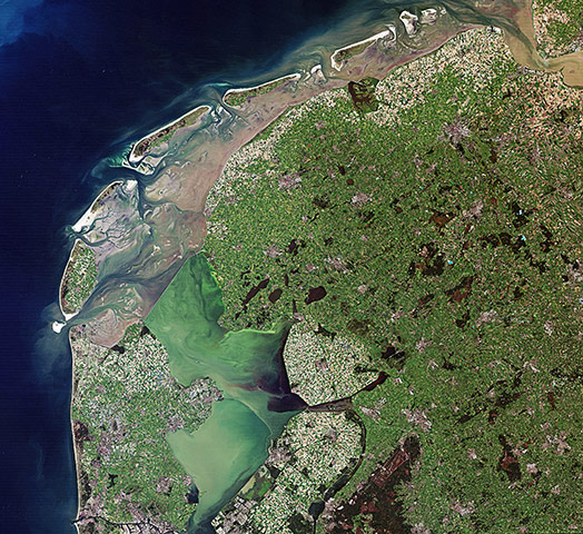
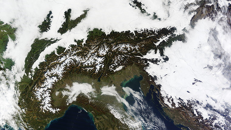
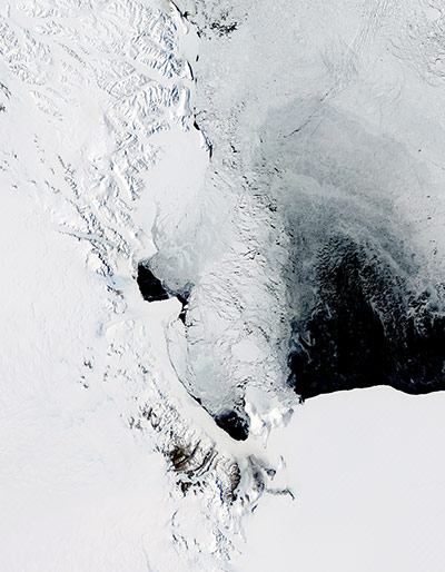
The intertidal Wadden Sea and two shallow, artificial lakes in the Netherlands. Visible in the image is the Afsluitdijk – a causeway that creates a division between the Wadden Sea to the north and the former Zuiderzee bay to the south. After the dyke was built, the Dutch were able to reclaim land from the sea – like the lighter coloured areas in the lower-central part of the imagePhotograph: Landsat/ESAA massive cloudbank covered central Europe in early November 2011, with clouds extending from the North Sea to the foothills of the Alps. Over the crescent-shaped mountain range, skies remained clearPhotograph: MODIS/Terra/NASAA polynya off the coast of Antarctica, near Ross Island and McMurdo Station. Persistent areas of open water amid sea ice are known as polynyas. Often the result of the upwelling of warm ocean water, polynyas can also result from winds. The polynya was likely caused by katabatic winds, which derive their name from the Greek term for 'descent'Photograph: MODIS/Aqua/NASA
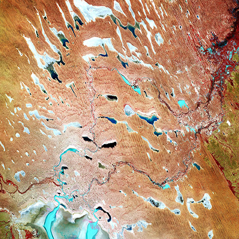
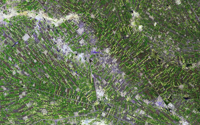
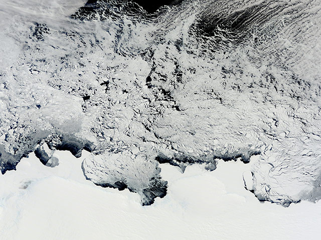
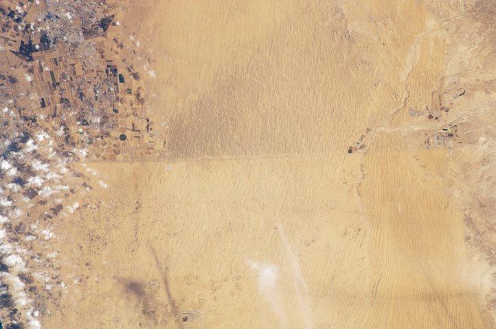
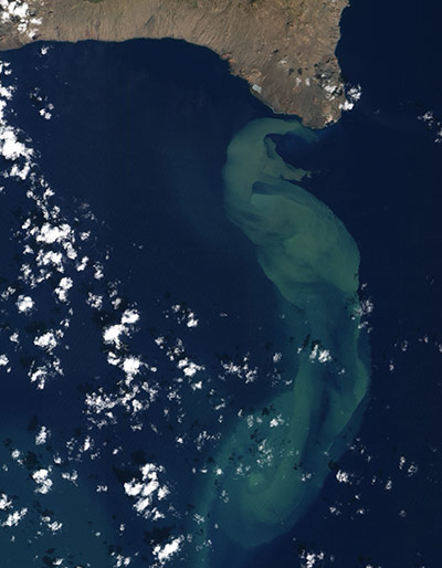
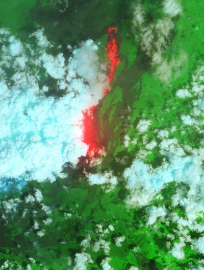
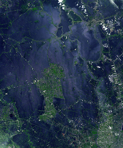
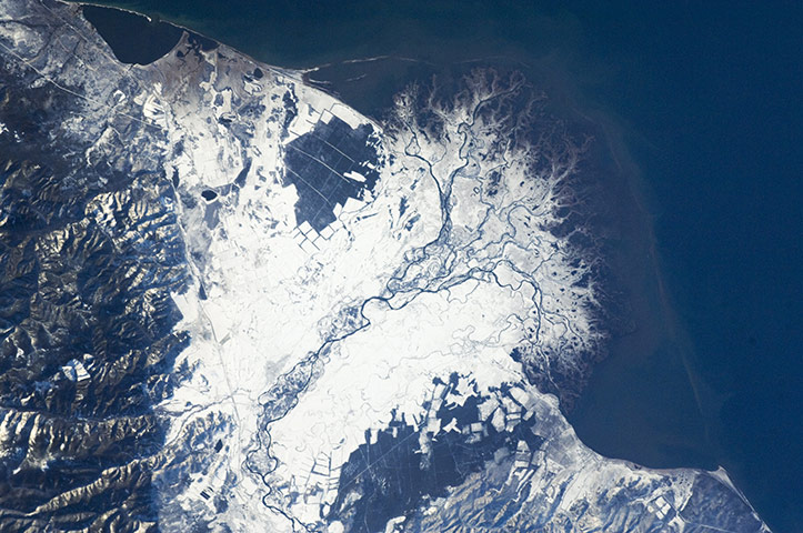
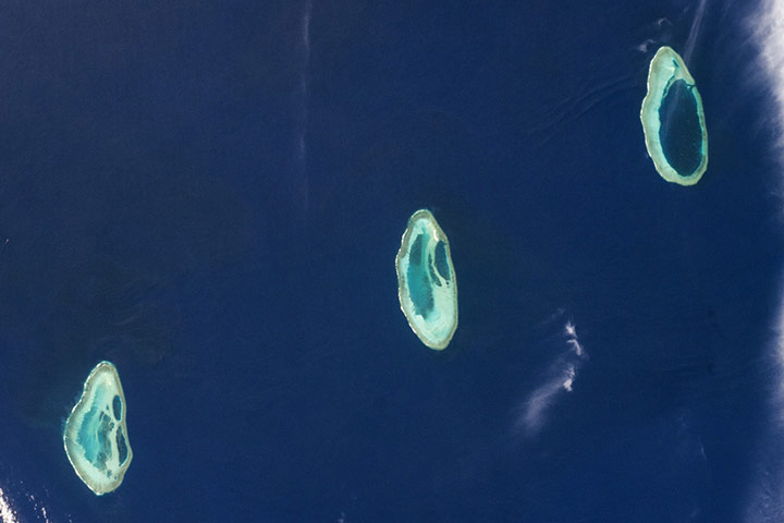
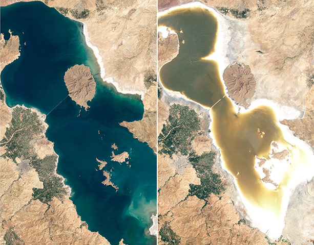
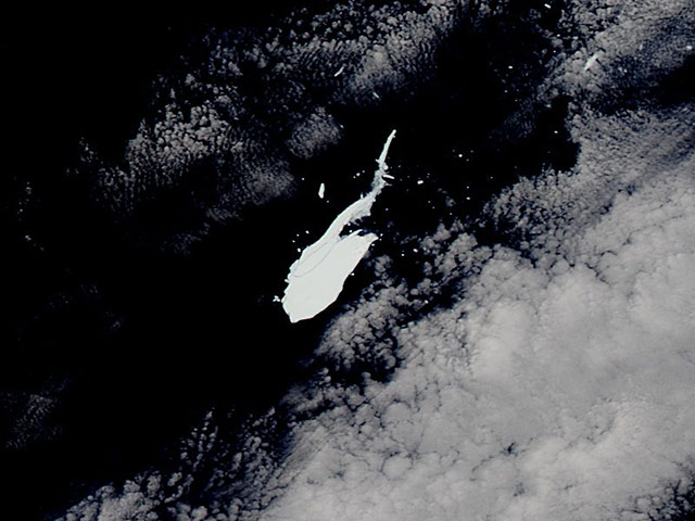
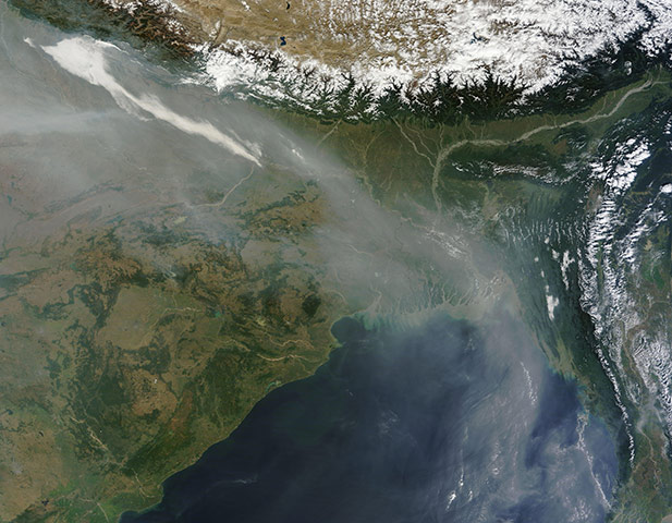
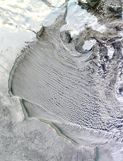
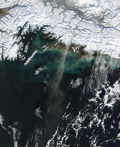
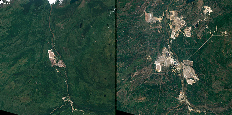
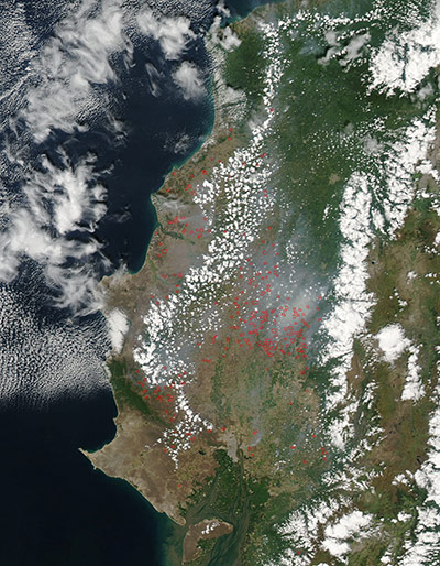
A portion of Lake Eyre (lower-left corner) and the north-south sand dunes of the Simpson and Tirari deserts in the remote outback of South AustraliaPhotograph: Landsat 5/ESAIn central Sudan, between the White and Blue Niles south of Khartoum, lies the province of Al Jazirah. Due to its great fertility, the area was targeted as a major cotton-growing region, and a network of canals was built to bring water to the fields. It has become Sudan's major agricultural region, with wheat production replacing about one-third of the cotton acreagePhotograph: ASTER/NASAIn early November 2011, the slowly increasing light of springtime in the Antarctic revealed stunning image of the ice-covered lands of Knox, Budd Law Dome and Sabrina coasts as well as the sea ice covering the southern Indian Ocean. The sea ice afloat on the ocean appears to have a blue cast, but the ice of the continent and the ice shelves are both similarly bright white. Upon close examination, however, it is possible to distinguish the rippled texture of the actual land surface from the smooth surface of the ice shelf on the coastlinePhotograph: MODIS/Terra/NASAA clearly visible line marks about 50km of the international border between Egypt and Israel in this astronaut photograph. The different colours of the land surface are the result of trampling by humans and their livestock. Trampling disturbs the dark-coloured soil crusts on the Egyptian side of the border, allowing lighter-colored dune sand beneath the crusts to be exposed by winds. A road also follows the border, making the demarcation more prominent. A patch of the Gaza strip appears at extreme image left. In the arid to semi-arid climate of the region, the natural vegetation is mostly sparse shrubs. Irrigated commercial agriculture in Israel appears as a series of large angular patterns and circular centre pivot fields, with darker greens indicating growing crops (image left)Photograph: ISS/NASAThe submarine volcanic eruption that began in mid-October in the Canary Islands continued in early November 2011. The volcanic island of El Hierro sits on a tectonic hot spot in the Atlantic Ocean off of North Africa and Spain. The waters south of the island have been bubbling and fizzing with heat, sediment, bits of volcanic rock, and minerals for weeks, with the plume stretching tens of kilometres. The eruption is believed to be venting about 500-100m below the water surface, and it is warming the waters by as much as 10C, according to geologistsPhotograph: ALI/EO-1/NASAOn 6 November 2011, after more than a year of relative inactivity, the Nyamuragira volcano in the Democratic Republic of Congo came back to life. Lava has erupted spectacularly from a fissure low on one of the volcano's flanks and spilled northward, away from populated areas. Nyamuragira is a shield volcano and one of Africa's most activePhotograph: ALI/EO-1/NASAThe flooding from the Chao Phraya River, Thailand, had slowly ebbed for more than a week when this image was acquired on 8 November 2011. The muddy water that had overflowed the banks of the river, flooding agricultural fields and villages, is depicted in dark blue and blue-grey. Vegetation and agricultural fields are green, except where they are inundated by flood waters and appear blackPhotograph: ASTER/Terra/NASAThe Selenga River delta is an intricate network of channels and levees surrounded by marshlands which is built out into Lake Baikal in Russia. The development of the delta is governed by the sediment load carried by the river, and any modifications due to lake tides or waves are relatively minor. Further out into the lake, dark brown deposits are visible, forming a rough arc marking the edge of the delta. Snow cover on the river floodplain highlights numerous secondary channels, as well as channels previously occupied by the river but now abandoned. The snow cover also traces the outlines of agricultural fields to the south-west and north-eastPhotograph: ISS/NASAThis astronaut photograph highlights the coral reef atolls known as Rowley Shoals, located in the south-western Timor Sea. Three reef areas make up the shoals - Mermaid Reef, Clerke Reef, and Imperieuse Reef - which extend approximately 100km (62 miles) from north-east to south-west. Rowley Shoals is located off north Western Australia, approximately 300km west of the city of Broome. The biodiversity of the atolls is impressive, with 233 coral species and 688 fish species more typical of south-east Asia than other Western Australian reef ecosystemsPhotograph: ISS/NASALake Orumiyeh (also Orumieh or Urmia) in north-western Iran is one of the world’s largest landlocked salt lakes, but it is shrinking like this two pictures show on August 13, 2011 (right), and August 25, 1998 (left). The cause of Orumiyeh’s depletion has been disputed. The Iranian government blames climate change and drought, while many citizens blame damming of rivers by the government, the Guardian reportedPhotograph: Landsat/NASAIn 2000 the Ross Ice Shelf calved one of the world's largest icebergs, which was estimated to measure about 295 km (183 miles) long and 37 km (23 miles) wide, with a surface area of 11,000 square kilometers (4,150 square miles). Over a decade later, and after breaking into several pieces, the iceberg still lingers in the Southern Ocean. On 14 November 2011, Aqua satellite captured this image of Iceberg B-15J, the largest remnant of the original icebergPhotograph: MODIS/Aqua/NASAIn early November 2011, haze hovered along the southern slopes of the Himalayas for days. The haze 'river' flowed toward the south-east along the mountain range, and turned southward over Bangladesh. Farmers in north-western India frequently set agricultural fires at this time of year, which no doubt contributed. Other factors likely include urban and industrial pollutionPhotograph: MODIS/Terra/NASACloud streets in Hudson Bay, Canada on 20 November 2011. A 'cloud street' is made up of long rolls of counter-rotating air that are parallel to the ground. These are basically eddies in the atmosphere that help transport moisture, heat and pollutants within the boundary layer of the atmosphere. Cloud streets form when cold air blows over warmer waters, while a warmer air layer - or temperature inversion - rests over top of bothPhotograph: Terra/NASADust blew over the Gulf of Alaska in early November 2011. Blowing toward the south-south-west, the dust plume remains discernible for roughly 100km (60 miles). The dust emerges from the Copper River Valley, which zigzags through the glacier-rich Chugach Mountains. The slow movement of glaciers over bedrock grinds the rock into glacial flour. This fine sediment is easily lofted into the air by winds blowing through mountain valleys. This image also shows swirls of iridescent green in the waters along the shore. The bright green probably results from sediment and phytoplankton. Dust can fertilise phytoplankton, prompting big blooms, but the microscopic organisms also thrive in high-latitude seas especially near coastlines, without dustPhotograph: MODIS/Terra/NASAOil sand mining began in Alberta in 1967. That first mine is closest to the Athabasca River in the left-hand image (1984). The mining operation includes a tan pit mine, processing equipment, and tailings ponds, where water and minerals are stored after the oil is removed. By 2011, pit mines surrounded the Athabasca River. The Mildred Lake Mine, west of the river, began operation in 1996. The Millennium and Steepbank Mines also developed on the east side of the river in the following decade. Additional mines are visible to the north in the large image. In 2010, surface mines produced 356.99 million barrels of crude oilPhotograph: NASAOn 18 November 2011, fires were detected (seen as this image in red dots) in the coastal province of Santa Elena, Ecuador, and further inland (east) in the province of Guayas. Fires also appear to be burning in Machalilla national park, a preserve in the Ecuadorian Manabí provincePhotograph: MODIS/Aqua/NASA
Sign up to read this article
Read news from 100’s of titles, curated specifically for you.