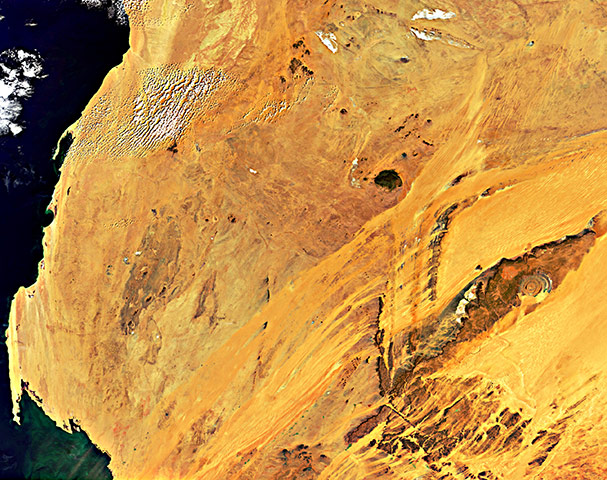
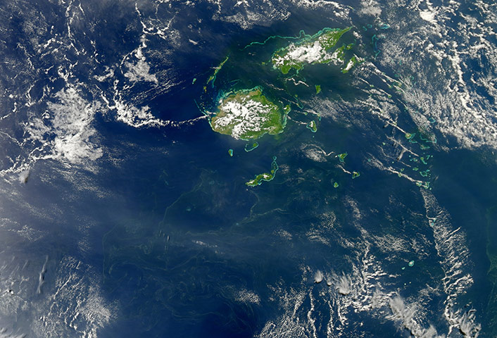
From mainland Ukraine, the Crimean peninsula extends southward, bordered on the west by the Black Sea and on the east by the Sea of Azov. Stretching across the peninsula is a network of shallow, marshy inlets sprawling over roughly 1,000 square miles. This network of lagoons is known as Sivash (also Syvash or Sivasÿ). The region is nicknamed the Rotten Sea and the Putrid Sea because during the summer months, the warmed marsh waters give off unpleasant odours. The shallow waters and varied chemical composition of the Sivash lagoons contribute to their bright colours of peach, mustard, lime green, blue, blue-green, beige, and brown. Thick layers of silt coat the bottoms of the shallow marshes, which are rich enough in mineral salts to supply a local chemical plantPhotograph: Landsat 5/NASASpectacular geological phenomena in the Sahara of Mauritania in northern Africa: the remarkable circular Richat structure (right), which resembles an eye from space, and a magnetic mountain, the Kediet ej Jill Mountain, Mauritania’s highest peak, visible north-west of RichatPhotograph: Envisat/ESASome of the smallest organisms on our planet can be viewed from space. Diminutive bacteria and plankton (microscopic, floating plants) can merge into great chains and mats that can be detected by satellites hundreds of miles up. This image of a plankton or bacterial bloom south of Fiji and though it is impossible to identify the species from space, it is likely that the yellow-green filaments are miles-long colonies of Trichodesmium, a form of cyanobacteria often found in tropical waters. Trichodesmium tends to grow in warm, nutrient-poor waters that are well lit by the sun and otherwise devoid of most life. These cyanobacteria can make their own food, absorbing and using nitrogen from the open ocean and the air to fuel their growth. They 'fix' nitrogen, just as certain plant legumes do on land. Sailors often call it 'sea sawdust'Photograph: Aqua/MODIS/NASA
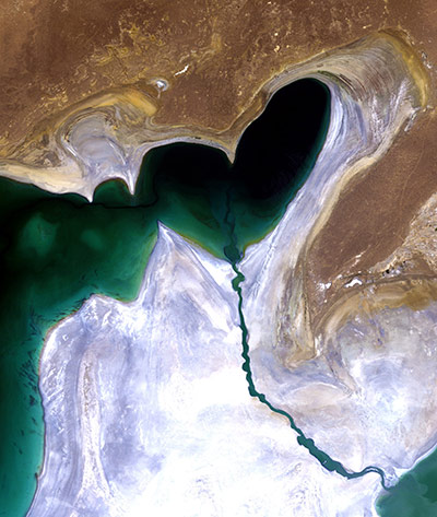
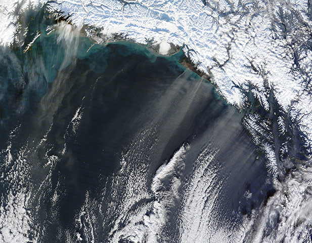
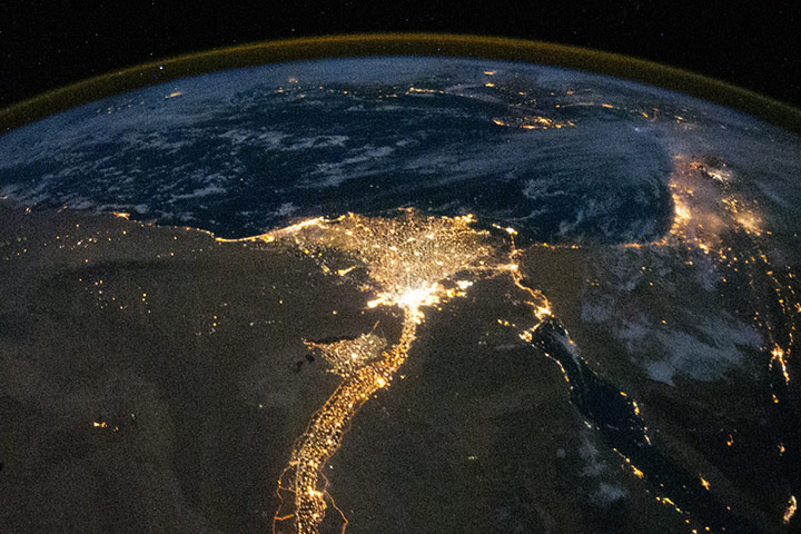
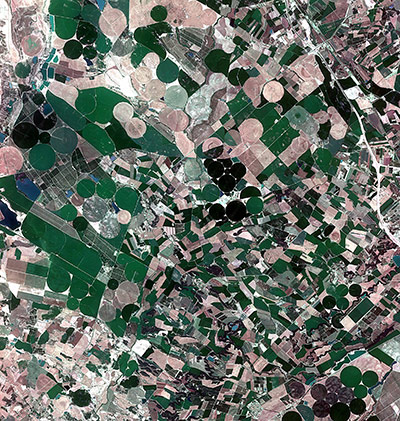
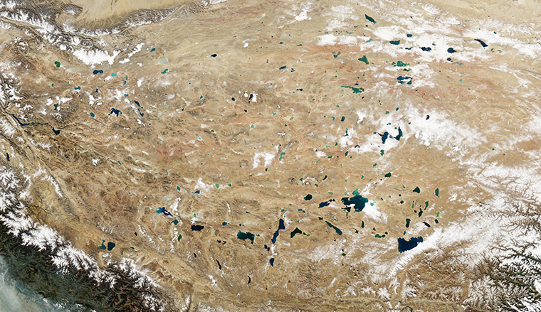
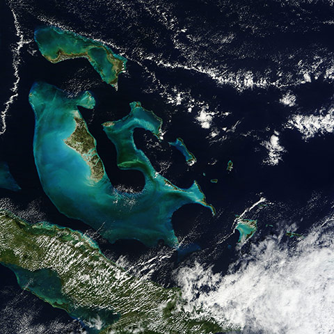
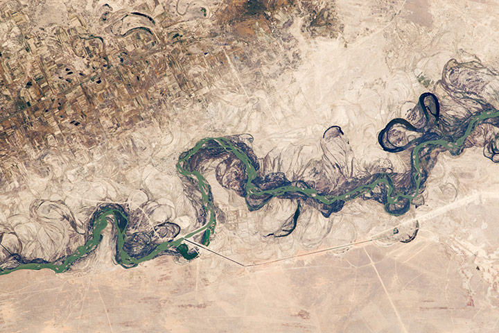
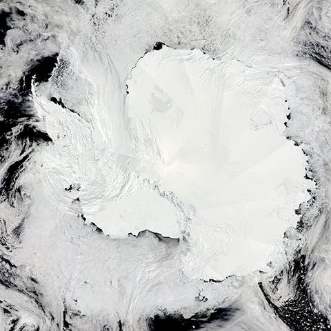
Heart-shaped northern tip of the western half of the Large Aral Sea (or South Aral Sea) in central Asia. The whitish area surrounding the lakebed is a vast salt plain, now called the Aralkum Desert, left behind by the evaporating seaPhotograph: Landsat/ESADust storms occur at high latitudes as well as in desert regions. One such storm left streamers over the Gulf of Alaska in mid-November 2010. Thin plumes of beige dust blow off the Alaskan coast toward the south-southwest. Farther to the south, lines of clouds mimic the shape and direction of the dust plumes, and even cast shadows on them. The dust plumes and clouds were likely shaped by the same winds. Malaspina is just one of many glaciers fringing the Alaskan coastline. As glaciers grind over rocks, they pulverize some of the rock into glacial flour. Melt water percolating through glaciers often deposits glacial flour in mud plains. When the plains dry out, winds sometimes carry dust particles aloftPhotograph: Terra/MODIS/NASAMore than three months after floods first struck Pakistan, waters still lingered west of the Indus River. At the beginning of November, the high waters were receding, but only slowly. The images document the formation of a massive floodwater lake terminating in Manchhar (or Manchar) LakePhotograph: Terra/MODIS/NASAThis image shows an eclectic montage of landscapes in Iran's largest desert, the Dasht-e Kavir, or Great Salt Desert. The word kavir is Persian for salt marsh. The almost uninhabited region covers an area of more than 29,730 square miles and is a mix of dry streambeds, desert plateaus, mudflats, and salt marshes. Extreme heat, dramatic daily temperature swings, and violent storms are the norm in this inhospitable placePhotograph: NASALights show the distribution of Egypt's population is almost completely concentrated along the Nile Valley, just a small percentage of the country’s land areaPhotograph: ISS/NASAA true-colour image of internal waves emanating from the Lombok Strait and flowing into the North Australian Basin and the Java Sea. One set of waves, appearing as closely-spaced arcs, moves to the north-east into the Java Sea while a second set, with a broader and shallower pattern, appears in south. The Lombok Strait, a small sea channel between the islands of Bali and Lombok, is an important part of the Indonesian through-flow, an ocean current which transports relatively warm water from the Pacific Ocean to the Indian Ocean via the Indonesian archipelago. The floor of the Lombok Strait contains a sill, a horizontal ridge formation, in waters with a depth of less than 350 metres, which affects the water flow. In the southern part of the strait a huge amount of water, sometimes more than 4m cubic metres of water per second, is pushed over the sill, creating a large speed currentPhotograph: Terra/MODIS/NASAThe Matusevich glacier flows toward the coast of east Antarctica, pushing through a channel between the Lazarev Mountains and the north-western tip of the Wilson Hills. Constrained by surrounding rocks, the river of ice holds together. But stresses resulting from the glacier's movement make deep crevasses, or cracks, in the ice. After passing through the channel, the glacier has room to spread out as it floats on the ocean. The expanded area and the jostling of ocean waves prompts the ice to break apart, which it often does along existing crevassesPhotograph: EO-1/ALI/NASAThe dust that blew out of the Gobi two days earlier passed over the East China Sea, and the Sea of Japan on 12 November, 2010. A veil of dust forms an arc hundreds of kilometres long, and extends from the Yellow Sea to the northern Sea of Japan. Thick dust also blows over the nation of Japan. In the north-east, clouds hide parts of the dust plumePhotograph: Terra/MODIS/NASAThe meticulously planned cultivated landscape of the autonomous communities of Aragon (west) and Catalonia in north-eastern Spain. Many agricultural crops can be seen growing including wheat, barley, fruits and vegetables. The circular shape of many of the fields indicates central-pivot irrigation is being employed, in which a well drilled in the centre of each circle supplies water to a rotating series of sprinklersPhotograph: KOMPSAT-2/ESAThe Qinghai-Tibet Plateau not only gives rise to most of Asia's major rivers, it also holds a constellation of salt- and freshwater lakes. Due to differences in depth, sediments, and microscopic organisms in the various lakes, they collectively present a myriad of greens, blues, and teals when viewed from above. The lakes in this region typically lack outlets, allowing the accumulation of minerals that, combined with other features, influence lake colourPhotograph: Aqua/MODIS/NASAFrom space, bright peacock-blue waters surrounding the Bahama Islands stand out in striking contrast to the deep blue waters of the Atlantic. The glowing blue of the waters is a result of abundant reflection of light from shallow platforms which comprise the sea floor surrounding the islands. Some of the platforms are home to large living coral reefs, but where the water turbidity is high, such as in the Grand Bahama Banks, little living coral can be foundPhotograph: Terra/MODIS/NASACentral Asia’s most important cotton-growing region is concentrated in the floodplain of the Syr Darya. The river was one of the farthest points reached by the ancient Greek leader Alexander the Great. The floodplain is shown here as a tangle of meanders and loops. The darkest areas are brushy vegetation along the present course (filled with blue-green water); wisps of vegetation are also visible along flanking swampy depressions, or sloughs. An older floodplain appears as more diffuse dark vegetation (image upper left), where relict bends are overlain by a rectangular pattern of cotton fields. The straight channel of a new diversion canal – one of 16 from this point downstream – can be seen along the east bank of the riverPhotograph: ISS/NASAThe Central Andes is a varied palette of muted earth tones, while bright banks of marine stratocumulus clouds shroud the Pacific on a spring day in South America on 13 November, 2010. In the north, the tan coastal plains of Peru rise to the Altiplano, the most extensive area of high plateau on Earth outside of Tibet. Lake Titicaca, seen in this image as a deep inky blue splotch on the Altiplano, sits on the border of Peru and Bolivia. At 3,811 m (12,500 ft) above sea level, it is the highest commercially navigable lake in the world. To the east the deep greens of the Amazon rainforest are visible, although in some areas a thin blue haze veils the forest. A stark white circular pattern marks the Salar de Uyuni, the world's largest salt flatPhotograph: Terra/MODIS/NASAThe continent of Antarctica shines against the dark waters of the Southern Ocean on a sun-filled spring day. Surrounding the starkly white ice-covered land mass, large banks of clouds swirl over sea icePhotograph: Terra/MODIS/NASA
Sign up to read this article
Read news from 100’s of titles, curated specifically for you.