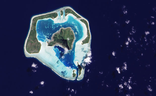
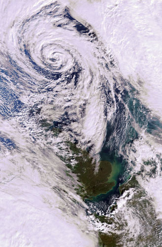
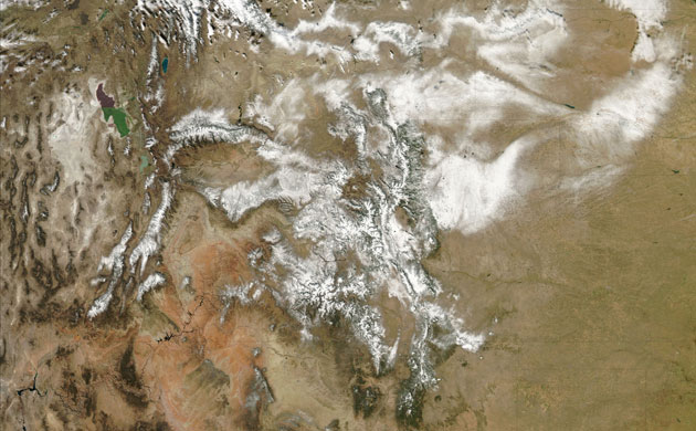
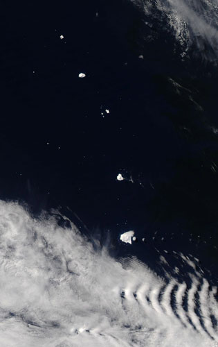
Spanning less than 10 kilometers (6 miles), Maupiti Island sits in the South Pacific Ocean, about 46 kilometers (29 miles) west of Bora Bora. The remote island lies 5,800 kilometers (3,600 miles) from Australia, and about 3,800 kilometers (2,400 miles) from New Zealand. Maupiti consists of a central island poking 213 meters (700 feet) above the sea surface, framed by low-profile serpentine islands and coral reefs that enclose a lagoon.Photograph: EO-1/guardian.co.ukA depression, or low pressure system, covering most of the North Sea, an arm of the Atlantic Ocean, on Monday 2 November 2009. The area of low pressure developed to the southwest of Britain brings heavy rains through England (visible), Wales (partly visible), Northern Ireland and Scotland (partly visible). The various colours of green visible in the sea around the River Thames in England are due to sediments being transported in the water. Western France is visible in the bottom right.Photograph: Envisat/guardian.co.ukWhite snow covers the Rocky Mountains on October 31, 2009. The Rocky Mountains actually run from Western Canada into the American West. There many landscape features visible on the higher resolution images. The Colorado River is fed by mountain snow in Colorado. The river itself can be seen winding across the pink deserts of the southeast corner of Utah and into northern Arizona where it cut the Grand Canyon. The Grand Canyon is visible in the northwest corner of Arizona, running approximately horizontally. The Painted Desert, pink and orange in color, is to its east, running southwards. The large lake visible in Utah, which looks half green and half purple, is the Great Salt Lake. The distinctly different coloration between the northern and southern arms of it is the result of a rock-filled causeway built in 1953 to support a permanent railroad. The causeway has resulted in decreased circulation between the two arms and higher salinity on the northern side.Photograph: Aqua/MODIS/guardian.co.uk
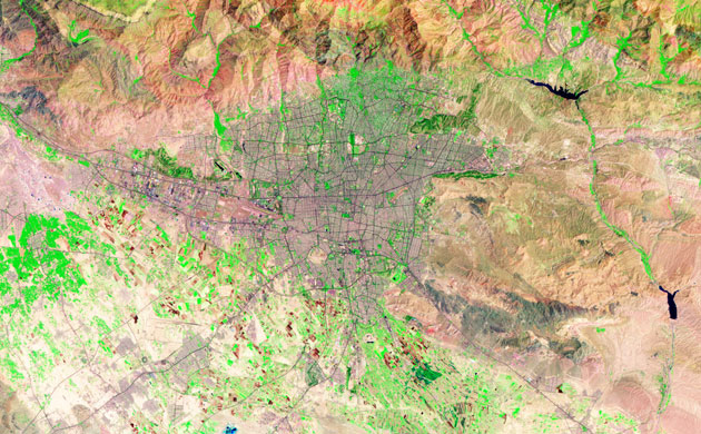
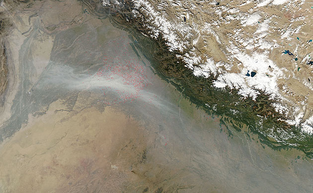
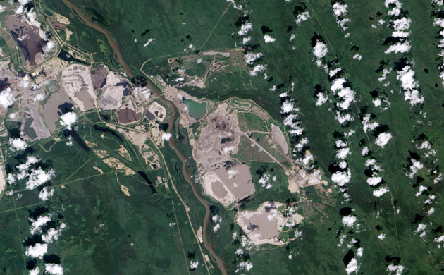
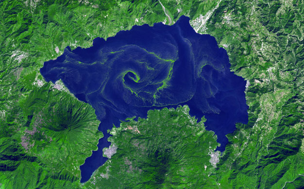
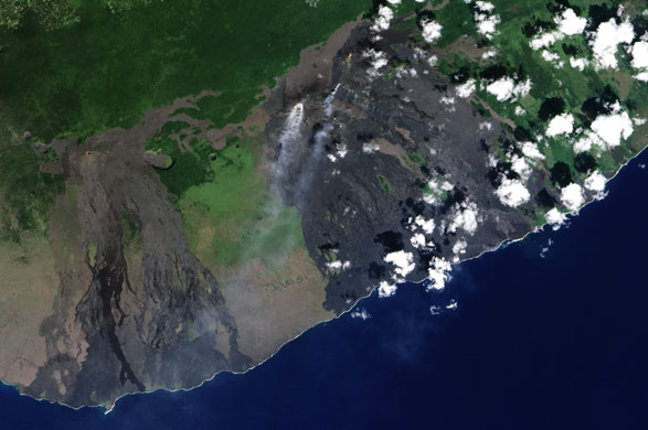
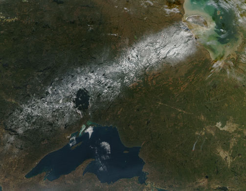
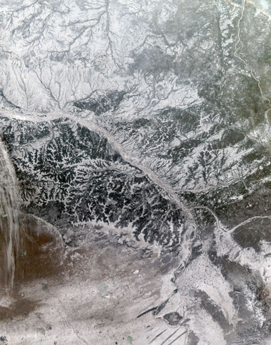
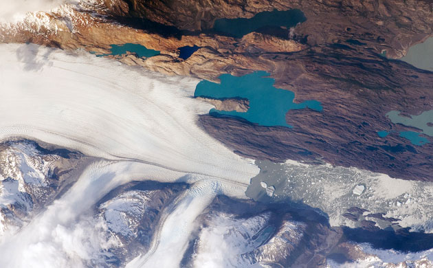
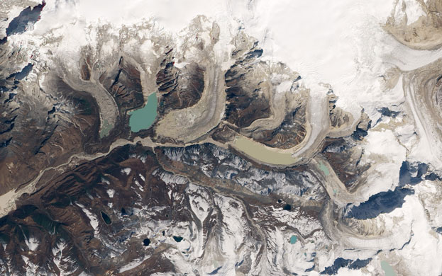
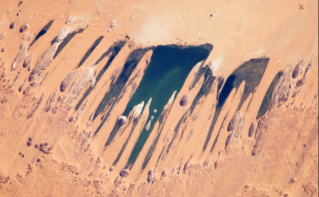
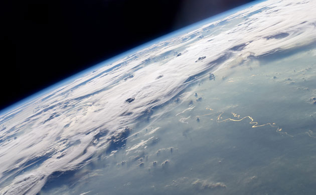
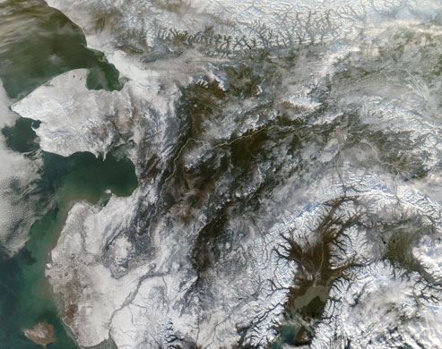
Tehran, Iran's capital, ranks among the world's fast-growing cities. In the early 1940s, Tehran's population was about 700,000. By 1966, it had risen to 3 million, and by 1986, during the Iran-Iraq war emigrants brought the population to 6 million. Today, the metropolitan area has more than 10 million residents, more than the sum of the country's next five major metropolitan areas combined. This explosive growth has environmental and public health consequences, including air and water pollution and the loss of arable land. Tehran sits on a gradually sloping plain between the Alborz Mountains in the north and the Great Salt Desert in the south. The city has been populated for thousands of years. It began as a village outside the ancient city of Ray, sitting at the intersection between the east-west Silk Road, and the north-south route between the Caspian Sea and Persian Gulf.Photograph: Landsat 5/guardian.co.ukJust days away from the beginning of the Southern Hemisphere's spring, Antarctica's Inexpressible Island and the Northern Foothills Mountains were illuminated by a glimmer of sunlight. The seaward slopes of the mountains are gleaming white, and they cast long shadows inland over the Nansen Ice Sheet. Terra Nova Bay appears in shadow. The scene provides indications of the bay's persistent and fierce katabatic winds, downslope winds that blow from the interior of the ice sheet toward the coast and appear in the open waters of Terra Nova Bay. Parallel white streamers are composed of newly formed sea ice, probably frazil - crystals just millimeters wide - and congealed frazil, called "grease ice" because it resembles an oil slick on the water. The ice is continually pushed out to sea by the strong offshore winds, leaving a pocket of open water, a polynya.Photograph: EO-1/guardian.co.ukThe South Sandwich Islands are located in the South Atlantic Ocean. They are remote and inhospitable, with no native population. There are some unique cloud patterns to the south of this island chain. The band-patterns are called "ship-wave-shaped clouds". They are called this because they resemble ship waves (or "Kelvin ship waves"), which are the V-shaped wakes left by moving objects, such as ships or even ducks..Ship-wave-shaped clouds are caused when wind flows past things like islands. The air is swept around and over it leaving a wake similar to that of a ship. The ship-wave-shaped cloud patterns form as the air alternately cools and warms on the wave peaks and troughs, causing clouds to form on the peaks, but not the troughs.Photograph: Aqua/MODIS/guardian.co.ukSeveral Latin American cities have grown up on the flanks of active volcanoes. This mosaic of two photographs illustrates the closeness of Arequipa, Peru, to the 5,822-meter- (19,100-foot-) high El Misti Volcano. The symmetric conical shape of El Misti is typical of a stratovolcano, a type of volcano characterized by alternating layers of lava and debris from explosive eruptions, such as ash and pyroclastic flows. El Misti most recent and relatively minor eruption occurred in 1985. The city center of Arequipa, Peru, lies only 17 kilometers (11 miles) away from the summit of El Misti; the gray urban area is bordered by green agricultural fields (image left). With almost 1 million residents in 2009, it is the second largest city in Peru in terms of population. The Chili River flows through a canyon (image right) between El Misti volcano and Nevado Chachani to the north. Photograph: ISS/guardian.co.ukThe skies over northwest India (right) were extremely hazy on November 1, 2009. Pakistan is on the left side of the image. Scores of fires (locations marked in red), probably related to agriculture, were puffing small plumes of smoke that coalesced into a thick river of haze to the south. The haze may also contain urban air pollution and dust. Note that the air on the other side of the Himalaya Mountains, is clear. Due to their height, the mountains create a sort of natural barricade that the smoke and haze can't cross.Photograph: Aqua/MODIS/guardian.co.ukIn the ranking of the world's proven oil reserves, Canada stands behind only Saudi Arabia. Canada possesses an estimated 178.6 billion barrels of crude oil accessible using current technology. Of this reserve, 174 billion barrels are in Alberta's oil sand fields, which cover 140,200 square kilometers (54,132 square miles) of the province. The largest oil sand field is Athabasca, shown here. The mines follow the course of the Athabasca River, the dark brown ribbon of water that runs down the center of the image. To separate the bitumen from the sand, refineries bathe the sands in hot water. The contaminated water cannot be returned to the Athabasca River, from which it was drawn, and it ends up in tailing ponds. The ponds replace natural wetlands and because they contain toxic chemicals, they are a threat to wildlife. In April 2008, hundreds of migrating ducks died after landing on a tailing pond, said news reports. Local residents worryPhotograph: EO-1/guardian.co.ukNormally a picturesque blue lake surrounded by steep volcanoes and Mayan settlements, Guatemala's Lake Atitlan acquired a film of green scum in October and November 2009. A large bloom of cyanobacteria, more commonly known as blue-green algae, spread across the lake in green filaments and strands that are clearly visible in this simulated-natural-color image from November 22, 2009. Cyanobacteria are single-celled organisms that rely on photosynthesis to turn sunlight into food. The bacteria grow swiftly when nutrients like phosphorus and nitrogen concentrate in still water. According to local news reports, the nutrients feeding the bloom in Lake Atitlan come from sewage, agricultural run off, and increased run off as a result of deforestation around the lake basin.Photograph: ASTER/guardian.co.ukThe rift zone on the eastern slopes of Hawaii's Kilauea Volcano has been erupting since January 1983, the longest eruption in recorded history. PuÔu ÔOÔo and the Thanksgiving Eve Breakout vent - two centers of volcanic activity - emit steam and other gases in this natural-color satellite image. Lava currently reaches the surface at the Thanksgiving Eve Breakout vent and flows southeast (towards the lower right) through a lave tube to the ocean. Small plumes of gas reveal the path of the lava. In general, the youngest lava flows are black, and older, weathered, flows are gray or brown. Surviving vegetation is bright green.Photograph: EO-1/guardian.co.ukA swatch of snow running across Ontario, Canada on November 18, 2009. At the bottom center of the image is Lake Superior, one of North America's "Great Lakes". The snow runs across a dark circular feature just north of Lake Superior. This is Lake Nipigon. Water from this lake drains into the Nipigon River and thence into Nipigon Bay of Lake Superior. In the top right corner of the image is James Bay, a body of water which is on the southern end of the Hudson Bay. This bay borders Ontario (to the west) and Quebec (to the east). the large half-moon shaped island is called Akimiski Island - it is actually part of the province of Nunavut. The coastal wetlands that Akimiski is emcompassed by includes mudflats and marshes, some tidal. Sediment is carried into this region of the James Bay by freshwater streams..The red dot is the location of an active fire...Photograph: Aqua/MODIS/guardian.co.ukSnowy and hazy central Russia is shown in this image captured on November 9, 2009. The Ob River dominates much of the image - it runs nearly diagonally across the scene. The Ob runs north and west where it is joined by the Irtysh River. The water from these rivers continues north where it empties into the Gulf of Ob, which is a long bay in the Kara Sea, which itself adjoins to the Arctic Ocean. Here is a map which shows the course the Ob River takes across Russia..Near the bottom center right of the image, the Ob bends and makes a W shape - part of the W is just cut off by the bottom of the image. Extending southwards from this section of the Ob are long dark marks in the landscape. They are better seen in this image from 2002. These lines, which run southward to the Kazakhstan border are wetland areas along tributaries of the Ob. additional wetlands are visible in the bowls of the Ob's "w".Photograph: Aqua/MODIS/NASAThe Southern Patagonian Icefield of Argentina and Chile is the southern remnant of the Patagonia Ice Sheet that covered the southern Andes Mountains during the last ice age. This detailed photograph illustrates the terminus of one of the icefield's many spectacular glaciers Upsala Glacier, located on the eastern side of the icefield. This image was taken during spring in the Southern Hemisphere, and icebergs were calving from the glacier terminus into the waters of Lago Argentino (Lake Argentina, image right). Two icebergs are especially interesting because they retain fragments of the moraine (rock debris) that forms a dark line along the upper surface of the glacier. Moraines are formed from rock and soil debris that accumulate along the front and sides of a flowing glacier. The glacier is like a bulldozer that pushes soil and rock in front of it, leaving debris on either side. Photograph: ISS/guardian.co.ukAs glaciers grind their way across the landscape, they pile up rocky debris, forming moraines. At the terminus of a glacier, moraines can act as natural dams for lakes filled with melt water. When they fail, they can create catastrophic glacial outburst floods. On October 7, 1994, in the Bhutan Himalaya, a partial collapse of a moraine along the edge of the Luggye Lake (first from right) released a glacial outburst flood that killed 21 people and swept away livestock, crops, and homes. This natural-color image of the southern slopes of Bhutan's Table Mountain shows where the 1994 glacial outburst flood occurred. Luggye Lake broke through the moraine at the southwest corner, and the flood scoured a path down the Pho Cho River. Unfortunately for residents down the valley, Luggye is not the only dangerous glacier in the region. Officials are also concerned about the Thorthormi Glacier Lake (center) and the unstable moraine separating it from Raphstreng Lake (green on left) , to the west.Photograph: EO-1/guardian.co.ukOne of the largest of a series of ten mostly fresh water lakes in the Ounianga Basin in the heart of the Sahara Desert of northeastern Chad. The lakes are remnants of a single large lake, probably tens of kilometers long, that once occupied this remote area approximately 14,800 to 5,500 years ago. As the climate dried out during the subsequent millennia, the lake shrank, and large, wind-driven sand dunes invaded the original depression, dividing it into several smaller basins. The area shown in this image is approximately 11 by 9 kilometers. Only one of the ten lakes is saline. The reason for the apparent paradox fresh water lakes in the heart of the desert is that fresh water from a very large aquifer reaches the surface in the Ounianga Depression. The aquifer is large enough to keep supplying the small lakes with water despite the high evaporation rate. Photograph: ISS/guardian.co.ukA picturesque line of thunderstorms and numerous circular cloud patterns filled the view as the International Space Station (ISS) Expedition 20 crew members looked out at the limb (blue line on the horizon) of the Earth. The region shown includes an unstable, active atmosphere forming a large area of cumulonimbus clouds in various stages of development. The crew was looking west-southwest from the Amazon Basin, along the Rio Madeira toward Bolivia when the image was taken. Sunglint -the mirror-like reflection of sunlight off a water surface directly back to the camera onboard the ISS- is visible on the waters of the Rio Madeira and Lago Acara in the Amazon Basin. Photograph: ISS/guardian.co.ukThe Bering Strait, on the left side of the image, is the body of water that separates Alaska's Seward Peninsula from Siberia to the west. The Strait is full of sea ice in the winter, but as it is still early in the season, ice hasn't formed yet, on November 1, 2009. Once it does form, it won't disappear until late spring. Running across the length of Alaska is the Yukon River; it empties into the Bering Sea and turns the waters closer to shore gray with sediments. It's especially visible toward the center of the image, where it appears white against the brown terrain..In the bottom right corner is the Cook Inlet. In this image it is surrounded by brown terrain, and then snowy mountains. This body of water is colored gray by fine glacial silt brought in by the Susitna River and its tributaries. The city of Anchorage is located at the eastern end of the Cook Inlet.Photograph: Aqua/MODIS/guardian.co.uk
Sign up to read this article
Read news from 100’s of titles, curated specifically for you.