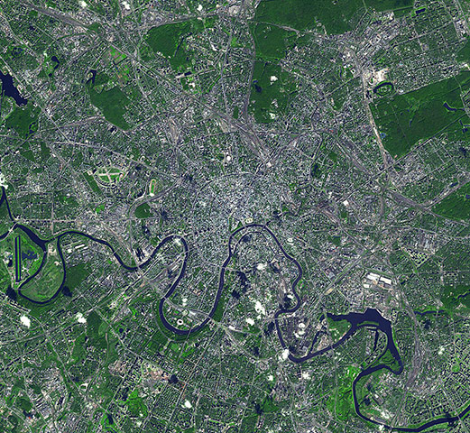
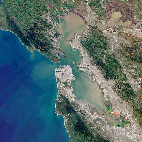
Moscow is the capital city of Russia; the northernmost megacity in the world; the most populous city in Europe, and with a population of more than 11 million people is the sixth largest city in the world. From its origins in the 12th century, Moscow served as the capital of the medieval grand duchy of Moscow, the tsardom of Russia and the Soviet Union. Strategically located on the Moskva River, Moscow is the site of the Kremlin, an ancient fortress that is now a world heritage sitePhotograph: ASTER/JPL/NASAThe sand seas of the Namib Desert. The blue and white area is the dry river bed of the Tsauchab. Black dots of vegetation are concentrated close to the river's main route, while salt deposits appear bright white. Running through the river valley, a road connects Sossusvlei to the Sesriem settlement. At the road's 45th kilometre, seen at the lower-central part of the image, a white path shoots off and ends at a circular parking area at the base of a dune. This is Dune 45, a popular tourist stop on the way to and from SossusvleiPhotograph: Kompsat/ESASan Pablo Bay and San Francisco Bay in natural colourPhotograph: ALI/Landsat 8/NASA
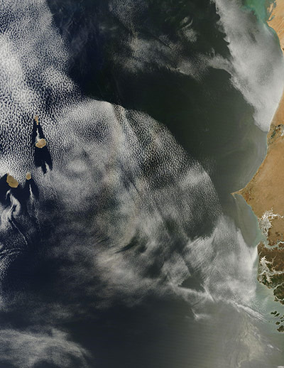
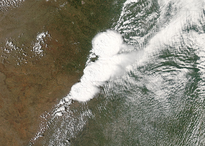
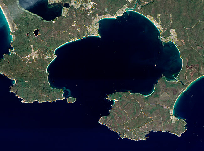
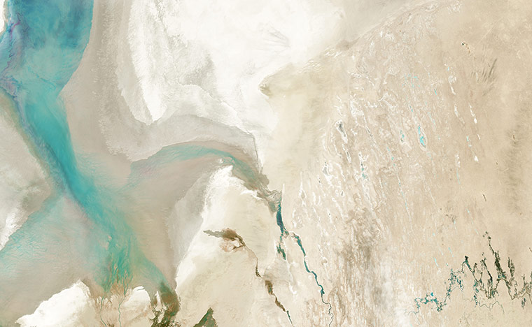
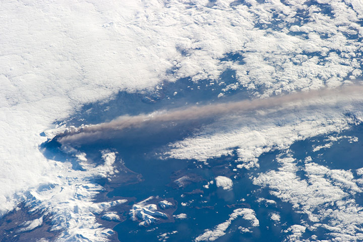
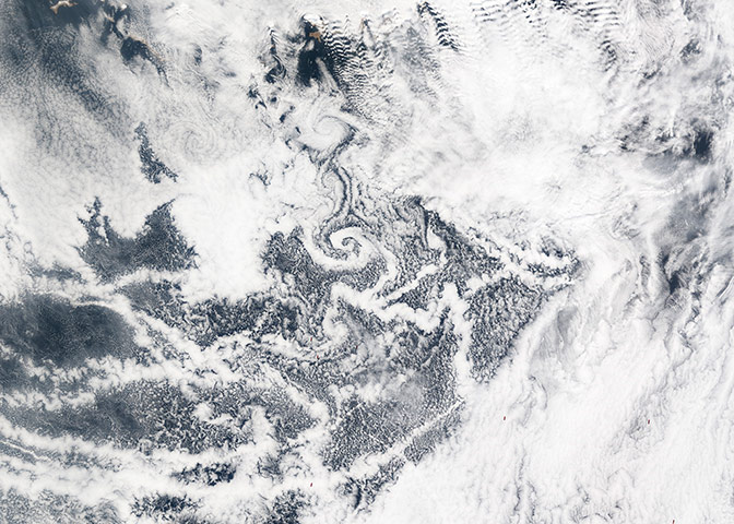
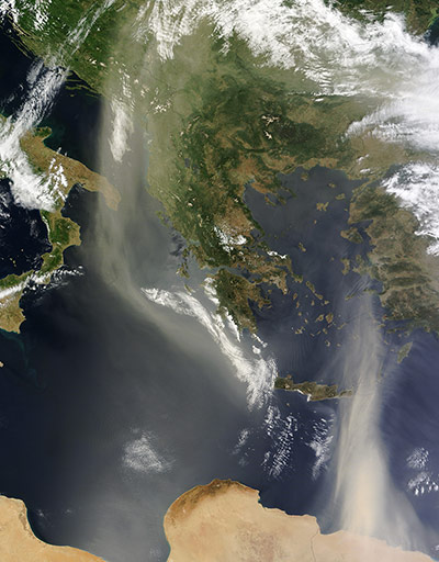
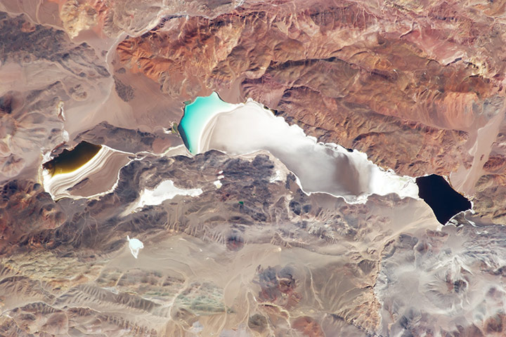
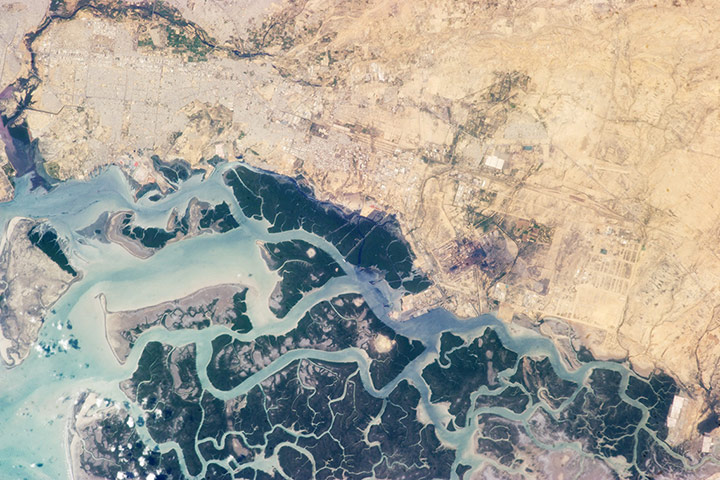
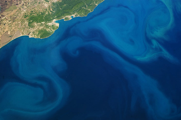
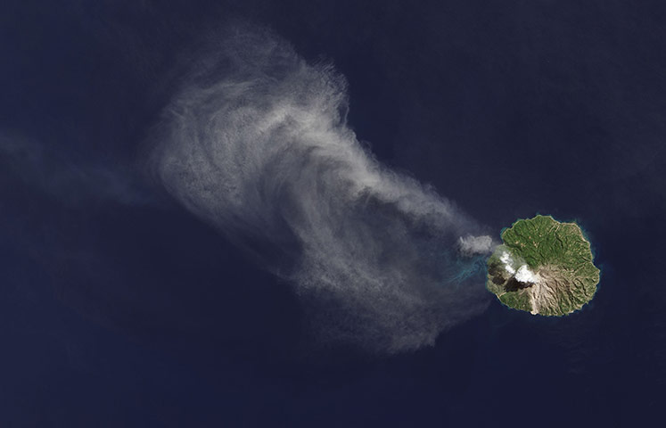
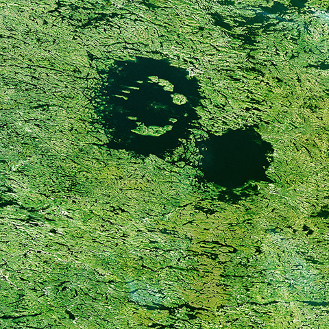
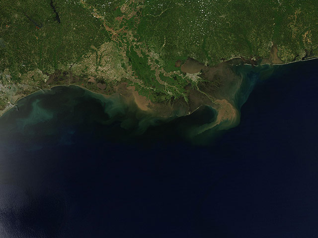
Rainbow-like discolouration that can be seen streaking across the bank of marine cumulus clouds near the centre of this image taken off the coast of West Africa is known as a 'glory'. This phenomenon is caused by the scattering of sunlight by a cloud made of water droplets that are all roughly the same size, and is only produced when the light is just right. In order for a glory to be viewed, the observer’s anti-solar point must fall on the cloud deck below. In this case the observer is the Terra satellite, and the anti-solar point is where the sun is directly behind you – 180 degrees from the satellite's line of sight. Water and ice particles in the cloud bend the light, breaking it into all its wavelengths, and the result is colourful flare, which may contain all of the colours of the rainbowPhotograph: Terra/MODIS/NASAA view of Earth taken on 20 May that shows the storm system in the south central US that generated the Moore Oklahoma tornado. The Moore twister was an F-4 tornado (winds between 166-200mph) that touched down around 2:52pm CDT and dissipated around 3:36pm Photograph: GOES-13/NOAA/NASAThis image was acquired just as the tornado began to strike. The tornado’s winds were estimated at 200-210mph at Briarwood Elementary School, near the centre of the tornado’s path, earning the storm the highest level of destructiveness on the Enhanced Fujita Scale: EF-5. Initial assessments estimate the cost of the damage will exceed $2bn, including $45m in damages to the school system. Two elementary schools were totally destroyed by the twister. Twenty four lives were lost, including 10 children. At least 350 people were injured. An estimated 13,000 homes were destroyedPhotograph: Aqua/MODIS/NASANasa’s Earth Observing-1 (EO-1) satellite captured this natural-colour image of Jervis Bay, Australia. Bright white sands line the coastline around Jervis Bay. When water erodes rocks and carries them downstream or out to sea, softer minerals slowly erode away. Quartz – composed of clear or white silicon dioxide crystals, or silica – resists erosion longer than other rock types. So the brilliant sands around Jervis Bay owe their colour (or lack of it) to the relentless action of water from old rivers, and rising and falling seas over thousands of years. According to the Guinness Book of Records, the sands around Jervis Bay are the whitest in the world. These sands are also finer than typical ocean beach sandPhotograph: ALI/EO-1/NASAOnce one of the largest inland seas in the world, the Aral Sea shrank to one-tenth of its original size after the former Soviet Union diverted its feeder rivers in the 1960sPhotograph: OLI/Landsat 8/NASAAstronauts aboard the International Space Station photographed these striking views of Pavlof volcano, Alaska peninsula, on 18 May 2013. Situated in the Aleutian Arc about 625 miles (1,000km) south-west of Anchorage, Pavlof began erupting on 13 May 2013Photograph: ISS/NASAStrong winds sent a wall of ice crashing into cottages along the south-western shore of Manitoba’s Dauphin Lake, northern Canada, on 10 May 2013. A total of 27 houses near Ochre Beach were damaged, 13 beyond repair. Events like this, known as ice shoves, occur when chunks of floating ice are pushed rapidly toward the shoreline by strong winds. When the leading edge of a raft of floating ice reaches shore, large slabs of ice can surge ashore if winds provide enough momentum. Ice shoves occur frequently along lakes in sparsely populated parts of northern Canada, but it is rare that they cause significant damagePhotograph: Terra/MODIS/NASAIndia has two lengthy mountain ranges that stretch along the country’s coasts - the Eastern Ghats and Western Ghats. They intersect in southern India in Tamil Nadu, near the Moyar River Gorge in an area called the Sigur Plateau, pictured here. As India’s population has grown, the plateau has emerged as a key wildlife corridor that sustains elephants, tigers, leopards, sloth bears, gaurs, and other vulnerable and endangered animals. The plateau has a growing human presence as well. Indigenous people have lived and farmed in the area for centuries. More recently, large tea and coffee farms have been established. While wildlife and humans have long competed for resources on the Sigur Plateau, the situation has grown particularly tense in recent yearsPhotograph: ALI/EO-1/NASAClouds that formed around ship exhaust (ship tracks) mingle with cloud vortices that had formed off of the Aleutian Islands. The ship-track clouds and cloud vortices occurred inside an area of relatively clear skies inside a larger expanse of marine clouds. The long, thin ship tracks stretched roughly east-west, and appeared slightly brighter than the surrounding marine cloudsPhotograph: Terra/MODIS/NASADust from North Africa swirls over the Mediterranean Sea on 29 May, 2013. At the top centre of the image is Greece, with Italy to the left and Turkey to the right. To the south are Libya and Egypt Photograph: Terra/MODIS/NASAWater of different colours lies within sub-basins of the Laguna (lake) Verde in the high Andes of north-west Argentina, at 4,095m above sea level. Laguna Verde often appears green, giving rise to its name. This image shows the turquoise tint in the central sub-basin (image centre), with a yellow to black tinge to water in the southern sub-basin (left) - also known locally as Laguna Negro. The northernmost basin (right) appears black. The reason for the color differences is that many different families of salt-loving organisms occupy hypersaline lakes such as Laguna Verde. These microscopic organisms appear as different colors, often bright, depending on the salinity and temperature of each water body or sub-basin Photograph: ISS/NASAThis photograph highlights the contrast between the highly urbanised and industrialised Korangi town, part of the Karachi metropolitan area of Pakistan, and the dense green mangrove forests and waterways of the Indus River delta to the south. Away from the river delta, vegetation cover disappears rapidly to the north-east. To the north and west, Korangi is bordered by the Malir, one of two rivers that pass through the Karachi metropolitan area. One of the largest industrial areas in Pakistan is located in Korangi. A conspicuously dark region marks the location of steel works. In addition to steel, the industrial area also includes textile, pharmaceutical, automobile, chemical, and flour industry facilitiesPhotograph: ISS/NASAThe Black Sea, a large inland water body that connects eastern Europe and Asia Minor, frequently hosts widespread blooms of phytoplankton during the spring and summer seasons. The phytoplankton are visible as blue to turquoise streams and swirls, carried by currents along the coastline and further out towards the middle of the sea. The urban areas of Anapa (left) and Novorossiysk (right) - the largest Russian seaport on the Black Sea - are visible along the northern shoreline as grey-white regions nestled between the sea and uplands dotted with limestone quarriesPhotograph: ISS/NASAPaluweh volcano spews ash over Indonesia’s Flores Sea Photograph: OLI/Landsat 8/NASAThe Clearwater Lakes in Canada's Quebec province. Located to the east of the Hudson Bay, what appears to be two separate lakes is actually a single body of water that fills two depressions. The depressions were created by two meteorite impacts, believed to have hit Earth simultaneously up to 290 million years agoPhotograph: Landsat/USGS/ESAThis image shows a portion of the Wilkins Ice Shelf and a large assemblage of icebergs and sea ice just off the shelf front in Antarctica. Some of the iceberg surfaces give clues that they recently broke off from the shelf: many are somewhat lighter in colour than the nearby sea ice, and some bear the same surface features as those seen on the shelf, including melt pond scars (which appear in pale blue). Melt pond scars are areas where meltwater once pooled on top of the ice and then refrozePhotograph: WorldView-2/DigitalGlobe/NASAThe Mississippi River, laden with soils and sediment from America's heartland following heavy spring flooding in the midwestern United States, twists like a tan-coloured snake across the landscape. The Mississippi drains about 1.25m square miles, or about 41% of the continental United States, including 31 states and two Canadian provinces. It has been estimated that the river carries roughly 50m tonnes of sediment into the Gulf of Mexico each yearPhotograph: Aqua/MODIS/NASA
Sign up to read this article
Read news from 100’s of titles, curated specifically for you.