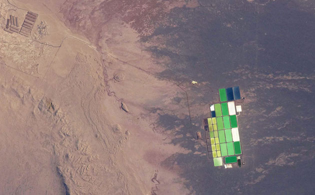
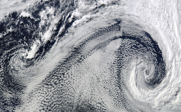
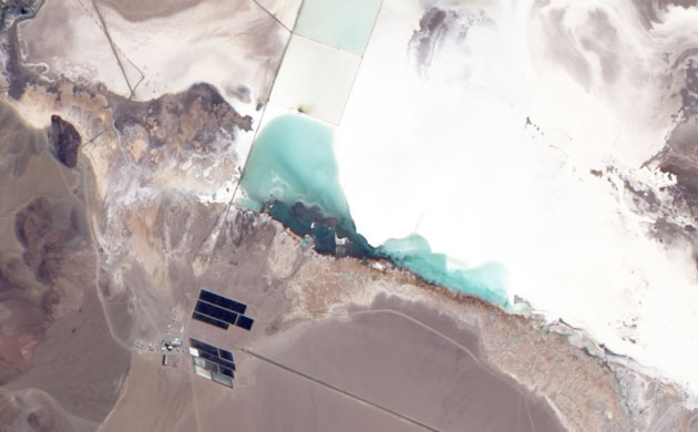
Brightly coloured salt ponds in a desert landscape give this astronaut's photo an unreal quality. The ponds sit near the foot of a long alluvial fan in the Pampa del Tamarugal, the great hyper-arid inner valley of Chile's Atacama Desert. Alluvial fans are common at the base of mountain ranges in arid and semi-arid regions and occur when a sediment-laden stream or river rapidly deposits its load as its speed is reduced on entering a plain. The sediments in this image are dark brown, and contrast sharply with the tan sediments of the Pampa del TamarugalPhotograph: NASAA Nasa satellite took a full five minutes to fly over this expansive cloud pattern over the cold waters of the south Atlantic Ocean. The swirling pattern has been formed by two cyclones that seem to be feeding on each other. Polar cyclones often form as a result of low-pressure systems over the ocean, and usually bring winds and heavy snowPhotograph: NASAIndonesia's Komodo national park, which includes three large and many small islands in Indonesia's Lesser Sunda Islands, was established in 1980 to protect the Komodo dragon species. Since then, the park's remit has expanded to protect terrestrial and marine habitats from the rapidly growing human population. In 1986, the UN heritage body Unesco made the park a world heritage site Photograph: NASA
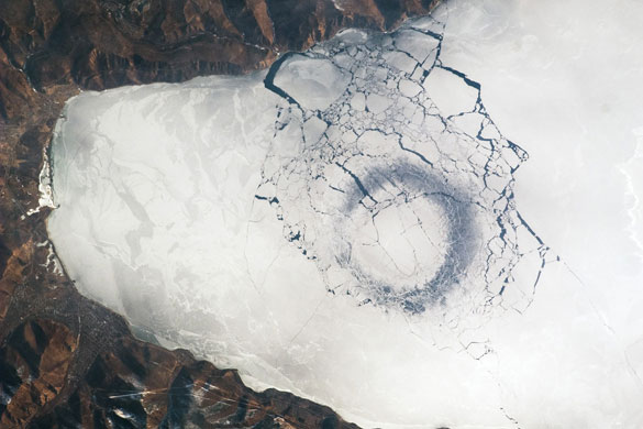
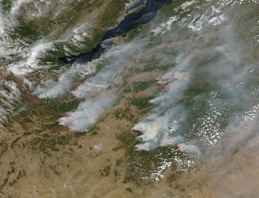
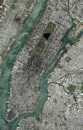
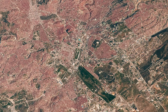
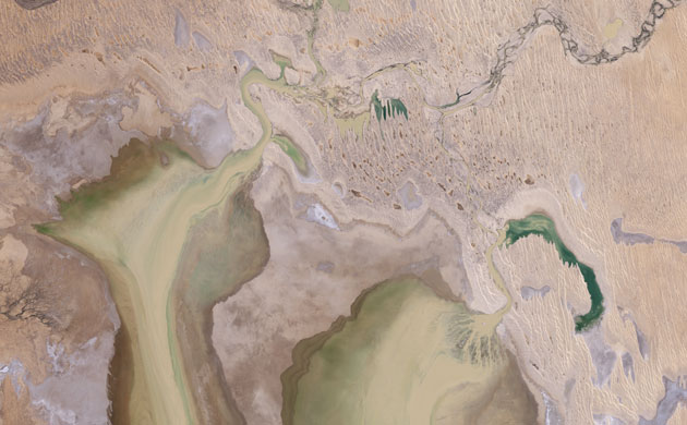
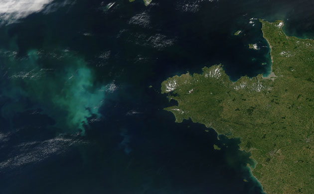
In late April, astronauts observed a strange circular area of thinned ice in the southern end of Lake Baikal in southern Siberia. Dark in colour, with a diameter of about 4.4km, the circle is the focal point for ice break-up in the very southern end of the lake and suggests convection - or upwelling - in the lake's water column. These circles are persistent as ice cover changes rapidly at this time of year: they appear when ice cover forms, and then disappear as ice melts. The pattern and appearance suggest that the ice is quite thinPhotograph: NASALarge fires in the forested mountains of Russia - south-east of Lake Baikal and in northern Mongolia's Selenge province - continued through May. Thick columns of smoke stream eastward from the fires, which are shown as red dots Photograph: NASAA satellite image showing the Manhattan, Queens, Bronx and Brooklyn boroughs of New York cityPhotograph: DigitalGlobe/GettyThis image shows the southern tip of the Florida peninsula, which juts outs into the Atlantic Ocean (right) and the Gulf of Mexico for more than 550km. The brown circular area in the centre is is Lake Okeechobee, the third largest freshwater lake in the United StatesPhotograph: ESAOn 10 May 10, California firefighters got a break when a marine inversion layer calmed the Jesusita fire, north of Santa Barbara. The fast-moving blaze had destroyed at least 137 structures and affected an estimated 8,733 acres. This weather pattern is common in California where cool air moving across the sea's surface hits the warmer land mass, resulting in San Francisco's famous fog Photograph: NASAThis image shows the capital city of Turkey, Ankara, which is situated in a region prone to major earthquakes. The city traces its roots back to a Hittite settlement founded prior to 1200 BC. A citadel built and occupied in turn by the Galatians, Romans, Byzantines, and Seljuks overlooks the central portion of the city. Perhaps an even more imposing structure is the mausoleum of the founder of the modern-day Republic of Turkey, Mustafa Kemal Ataturk, visible on an adjacent hill to the southwestPhotograph: NASAPlumes continued to rise from Kilauea volcano on Hawaii's Big Island in late May Photograph: NASANova Scotia’s Joggins fossil cliffs are a paleontologist’s dream: multiple layers of ancient forest with trees still in their standing positions and undisturbed animal tracks. The fossil cliffs trace a curving line through the middle of this image, with Cumberland basin to the west and a small village in the east. Sunlight and sediment colour the water of Cumberland basin in shades of pastel. On land, colours vary from deep green vegetation to brown bare rock to grey paved surfaces. Roads cut crooked lines through the landscape. The cliffs appear grey-beige, giving way to buff colour nearest the waterPhotograph: NASAThis image shows the southern part of Alaska, where snow-covered mountain ranges dominate the image. The crescent-shaped Alaska range is visible in the upper left corner. The Kenai mountains cover the southern and eastern portions of the Kenai peninsula (left of image centre), which is separated from the mainland by the Cook inlet, a bay of the Pacific Ocean that is visible west of the peninsula in shades of blue, green and tan. Anchorage, visible in light green, is situated at the head of Cook Inlet. Several rivers and lakes dot the peninsula. Lakes Tustumena (large light blue lake to the south), Skilak (above Tustumena) and Kenai (L-shaped lake north-east of Skilak) are clearly visiblePhotograph: ESAEl Salar del Hombre Muerto, Argentina: Brown and white dominate this true-colour image of the Salar del Hombre Muerto, in north-western Argentina. A salar is a salt pan, created when water repeatedly evaporates from a shallow lake, leaving behind a crusty layer of salt minerals which show as brilliant whitePhotograph: NASAWaves in central Australia's Simpson Desert usually come in the form of sand dunes. In these images, they ripple in long vertical lines across the surface of the desert. Occasionally, summer rain from northern Australia flows down into the desert, filling dry river channels and empty lake beds. Very occasionally, the water reaches a vast lake bed called Lake Eyre, turning it into a shallow inland sea where birds flock to breed. In early 2009, heavy rains brought major flooding to nearly every river system in Queensland, Australia. By May, the water had made its way south and had started to fill Lake Eyre. This image gives a natural-color view of water pouring into the lake through one of many channels that drain the desert during the rainy seasonPhotograph: NASAThe waters off the coast of Brittany, in north-western France, are coloured with bright greens and blues. This is a bloom of tiny marine organisms called phytoplankton, that, much like their land-based plant relatives, use sunlight to convert water and carbon dioxide into food. Some species of phytoplankton are coated with scales of calcium, which can turn the water electric blue. Chlorophyll and other light-capturing pigments in others give the water a deep green hue. Very dark green areas could be caused by extremely high levels of phytoplankton - so much light is being absorbed by chlorophyll that the water appears darkPhotograph: NASA
Sign up to read this article
Read news from 100’s of titles, curated specifically for you.