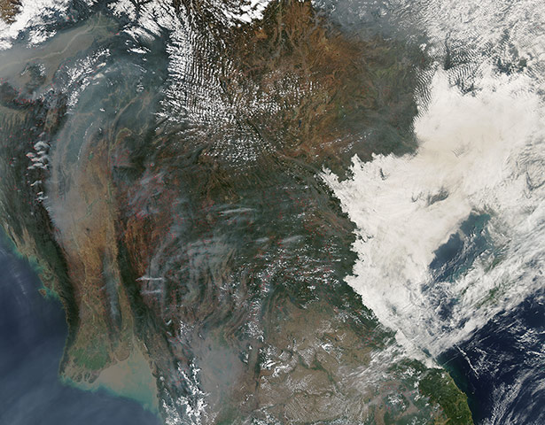
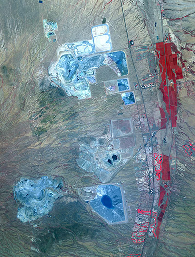
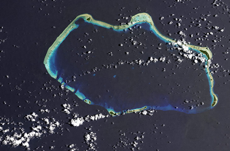
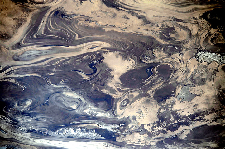
Agricultural fires continued to burn in south-east Asia in mid-March 2014. Red dots indicate where the thermal sensors on the satellite detected high temperatures. Heavy clusters of hotspots can be seen, from west to east, in south-eastern India, Burma and Laos. Thailand, south of Laos, is shrouded in heavy smoke but has relatively fewer fires. Along the eastern coast, Vietnam is covered by cloud. Fire is used in cropland areas for pest and weed control and to prepare fields for planting. Although this seasonal burning helps farmers with their crops, it has detrimental effects as vast amounts of smoke are released into the atmosphere, causing air pollution and adversely affecting health Photograph: MODIS/Terra/NASAArizona produces 60% of the total copper mined in the US. At the ASARCO-Mission complex, the Twin Buttes and Sierrita mines are large openpit operations extracting copper, silver, molybdenum, zinc, lead and gold. Enormous leach ponds and tailings piles surround the pitsPhotograph: JAROS/ERSDAC/METI/GSFC/NASASixty years ago, the United States detonated a thermonuclear bomb on Bikini Atoll in the Marshall Islands. This image shows the Castle Bravo crater left behind by the explosion, which was 1,000 times more powerful than the atomic bomb dropped on Hiroshima in August 1945. The hole is 2km (1.2 miles) across and 80 metres (260 feet) deep Photograph: OLI/Landsat-8
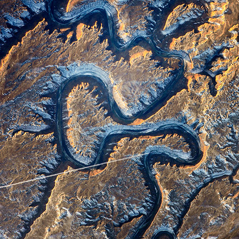
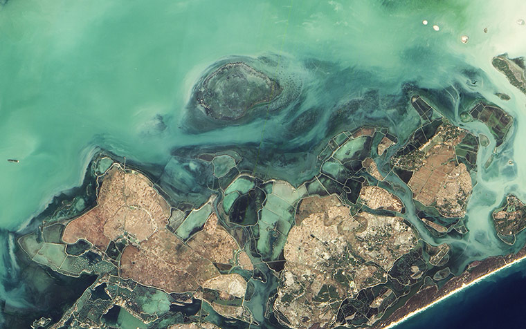
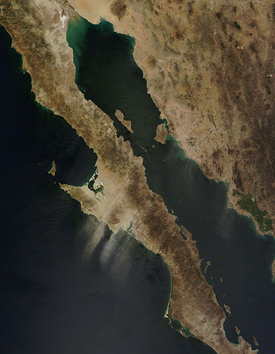
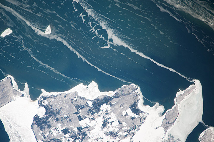
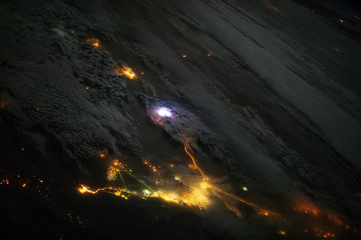
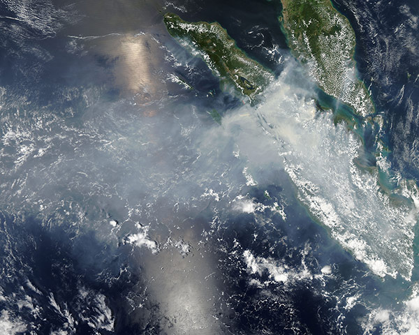
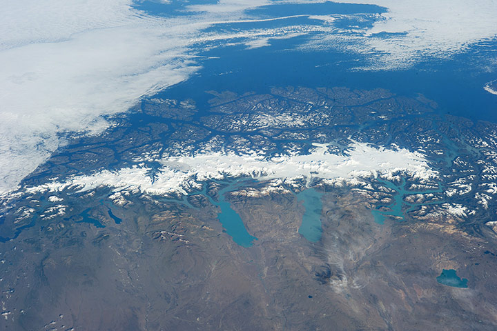
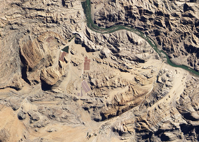
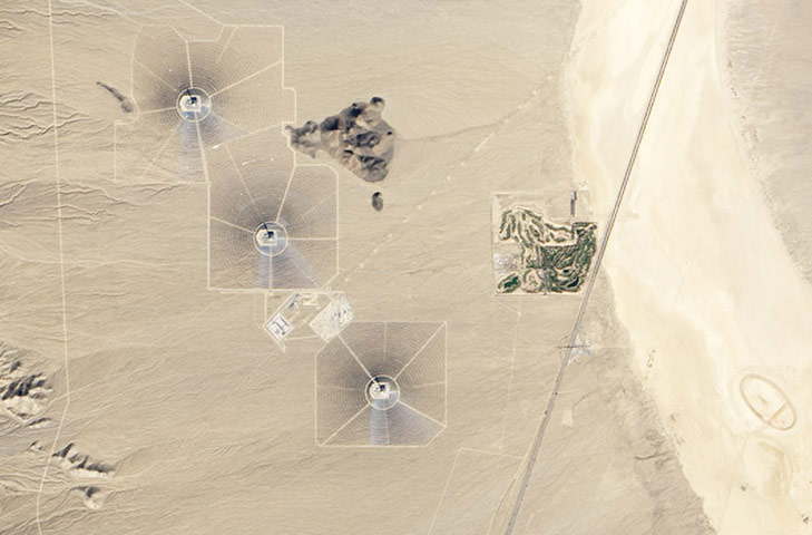
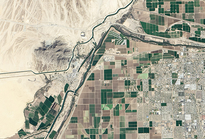
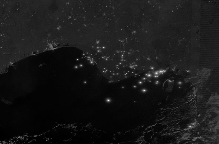
This sector of the Green River canyon in eastern Utah is known as Bowknot Bend because of the way the river doubles back on itself. In this photograph taken by an astronaut on the International Space Station, the Green River appears dark because it lies in deep shadow, 300m (1,000 feet) below the surrounding landscape. The yellow-tinged cliffs that face the rising sun give a sense of the steep canyon walls. The straight white line across the scene is the contrail from an aircraft that passed over Bowknot BendPhotograph: ISS/NASAChilika Lake is the largest lagoon in India and one of the largest in the world. The interplay between fresh water– that drains into the shallow lake from rivers to the north and west, and salty tidal water encroaching from the Bay of Bengal to the south – gives Chilika’s waters a brackish quality. Chilika, in southeastern India, is best known as a mecca for birds, which are attracted by the hundreds of species of fish and other aquatic life. During peak migratory season, the lake hosts more than 1 million birdsPhotograph: NASADust blew off of Baja California and over the Pacific Ocean on 16 March, 2014. The heavy tan bands of dust appear to arise from the western edge of the El Vizcaino desert, a dry, sandy part of the larger Baja California desert. Wind blows strongly from the north-east, lofting sand and dust high into the air. The plumes travel hundreds of kilometres south-west across Baja California and the Pacific OceanPhotograph: MODIS/Terra/NASASnow-covered fields appear as geometric patterns on Lake Michigan’s Washington Island. On the day this image was taken, south-westerly winds were blowing ice into the lake in the form of long, coherent 'ice stringers'. These dominant winds keep a narrow zone clear of ice, even as accumulations in the winter of 2014 reach the highest levels ever recorded in Lake MichiganPhotograph: ISS/NASAThis photograph, snapped by an astronaut aboard the International Space Station (ISS), shows a white flash of lightning amidst the yellow city lights of Kuwait and Saudi Arabia. Across the atmosphere of Earth, lightning flashes about 50 times per second. Using a new instrument on the station, scientists are hoping to observe and dissect at least a few of those lightning bolts every day. Fitted to the ISS in August 2013, the Firestation instrument includes photometers to measure lightning flashes, radio antennas to measure the static (a proxy for the strength of the electrical discharge), and a gamma-ray electron detectorPhotograph: ISS/NASAFires burning in Sumatra continued to pour smoke over the region in mid-March, bringing air quality to dangerous levelsPhotograph: MODIS/Aqua/NASAThis panorama of the Southern Patagonia ice field was photographed by a crew member aboard the International Space Station on a rare clear day in the southern Andes Mountains. With an area of 13,000 square kilometres, the ice field is the largest temperate ice sheet in the southern hemisphere. Storms that swirl into the region from the southern Pacific Ocean bring rain and snow, resulting in the build-up of the ice sheetPhotograph: ISS/NASAThe village of Klein Pella in South Africa’s Northern Cape province has one of the harshest climates in the country. Rain is scarce, with less than 10mm (0.4 inches) falling most months. Meanwhile, temperatures are typically hot in mid-summer, with highs averaging about 38C (99F). Today, water from the Orange River irrigates more than 87 hectares (215 acres) of Phoenix dactylifera, the type of palm that produces the Medjool datePhotograph: ALI/EO-1/NASAThree towers and surrounding arrays of mirrors at the Ivanpah Solar Electric Generating System in California, a few kilometres from the Nevada border. The new solar power plant in Ivanpah Valley sees 330 to 350 sunny days per year. Operators say they can generate up to 377 megawatts of electricity, enough to power more than 140,000 homesPhotograph: OLI/Landsat 8/NASAThe lack of soil and vegetation in the Kavir desert, central Iran, allows the geological structure of the rocks to appear quite clearly. The dark water of a lake (image centre) fills a depression in a more easily eroded, S-shaped layer of rock. The irregular, light-toned patch just left of the lake is a sand sheet thin enough to allow the underlying rock layers to be detected. A small river snakes across the bottom of the image. In this desert landscape, there are no fields or roads to give a sense of scale - the width of the image is about 105kmPhotograph: ISS/NASADue to increasing demand for Colorado River water by the United States and Mexico, the final stretch of the Lower Colorado has virtually disappeared. It has been decades since the Colorado flowed all the way through Mexico to the Gulf of California. Major spring floods are a rarity, and the lower reaches of the river only flow after rainstorms or when agricultural run-off drains into the dried riverbed. In March, researchers and water managers announced plans to bring back some water. The floodgates at a diversion dam near the US-Mexico border will be opened, sending a pulse of water rushing toward the delta once again. The 'pulse flow' from Morelos Dam is intended to simulate spring floods of the past. After the water subsides, ecologists expect to see a wave of green emerge, as the fresh water flushes away salts and helps cottonwood and willow seeds germinatePhotograph: OLI/Landsat 8/NASAAt night, gas flares outshine everything else in the Niger River delta except for the lights of Port Harcourt and Benin City. Nigeria contains more gas flares than any other country except Russia, and one of the lowest per capita electricity generation rates in the world. Only 50% of Nigeria’s population has access to electricity – most Nigerians rely on burning charcoal, wood, manure, and other bio-waste for cooking and heatingPhotograph: VIIRS/Suomi NPP/NASA
Sign up to read this article
Read news from 100’s of titles, curated specifically for you.