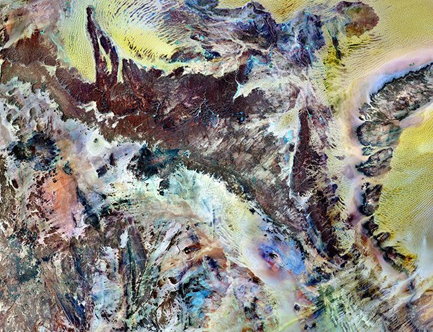
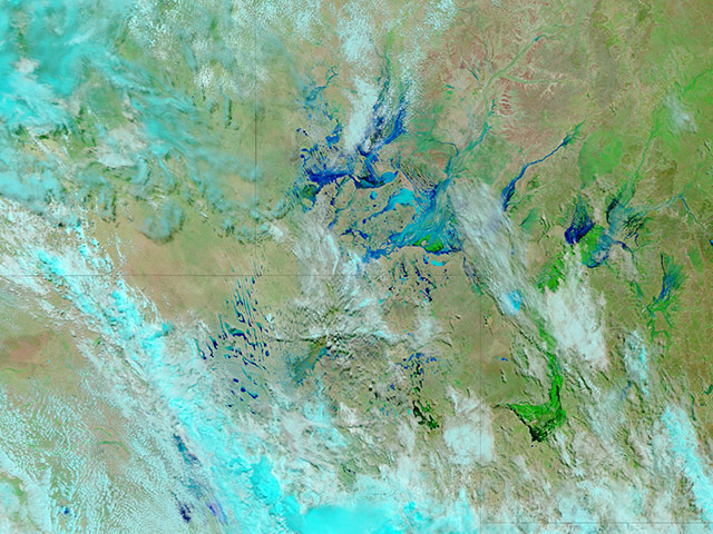
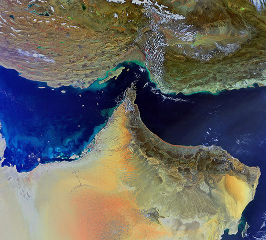
Tassili n’Ajjer national park covers 72,000 square kilometres (27,800 square miles) in south-eastern Algeria. Part of the Sahara Desert, the park has a bone-dry climate with scant rainfall, yet does not blend in with Saharan dunes. Instead, the rocky plateau rises above the surrounding sand seas. Rich in geologic and human history, Tassili n’Ajjer is a Unesco world heritage sitePhotograph: Landsat-7/NASAIn early March 2011, over a period of just six days, the appearance of Australia's channel country – a region of outback Australia located mostly in the state of Queensland but also in portions of South Australia, Northern Territory and New South Wales - changed dramatically. Rainwater filled typically dry river channels throughout the region, particularly in south-western Queensland. Channel country flooding is a fairly common occurrence at this time of year, but the summer of 2010-11 proved to be one of Australia's wettest on record, leading to extensive flooding. Average rainfall was reported to be 70% above normal. Meteorologists attributed the unusually heavy precipitation to La Niña weather patternsPhotograph: MODIS/Terra/NASAThis image shows the south-eastern parts of Iran (top) and the Arabian Peninsula. The closest point between the two Middle Eastern countries is the Strait of Hormuz (centre), which links the Persian Gulf (left) with the Gulf of Oman (upper right) and the Arabian Sea (lower right). Several countries are visible on the peninsula: the United Arab Emirates (top left), Oman (tip and bottom right) and Saudi Arabia (far left and bottom)Photograph: Envisat/ESA
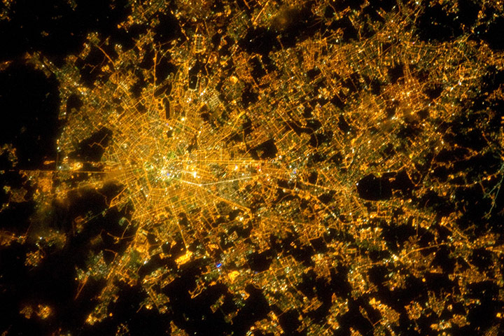
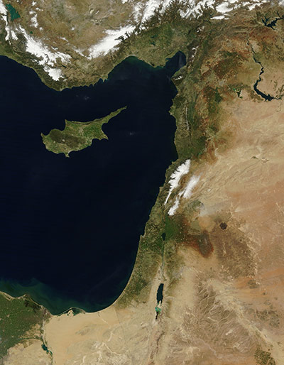
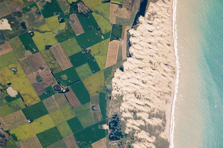
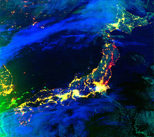
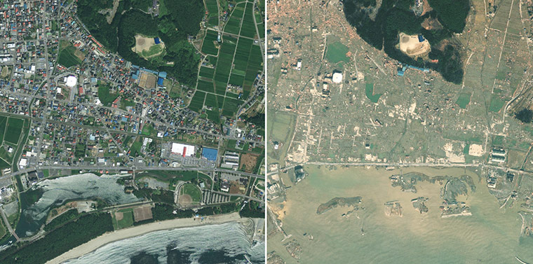
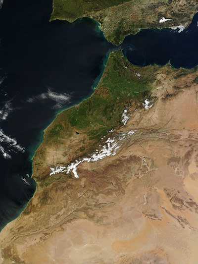
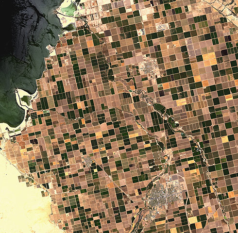
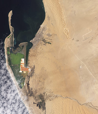
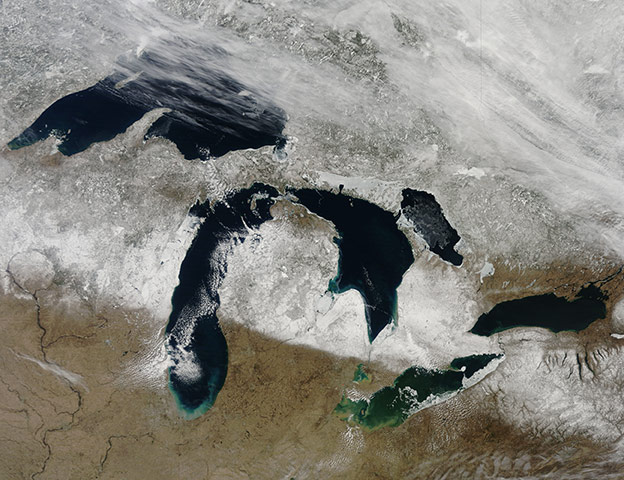
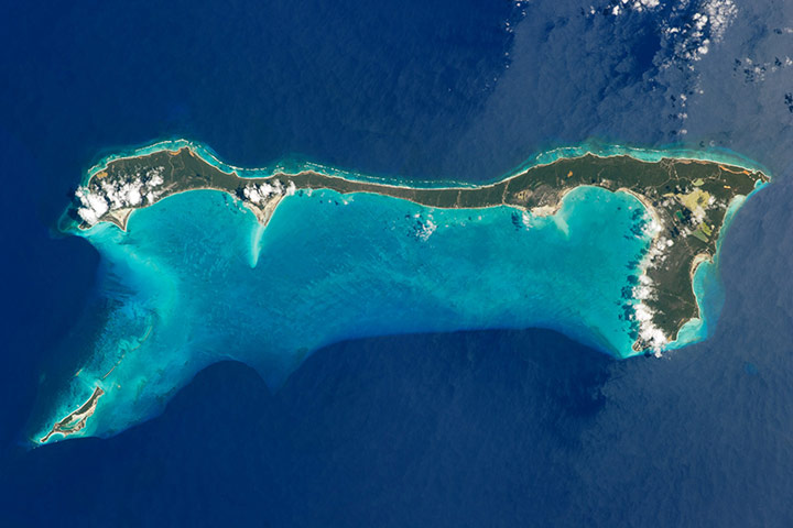
The metropolitan area of Milan in the Italian region of Lombardy is illuminated in a pattern evocative of a patchwork quilt. Brilliant white lights indicate the historic centre of the city where the Duomo di Milano (Milan cathedral) is located. Milan has the largest metropolitan area in Italy, and the fifth largest in the European UnionPhotograph: ISS/NASALate winter snows covered mountains in Lebanon and Turkey on 17 March. The moderate Mediterranean climate brings cool and sometimes rainy winters to the coasts, but in the higher elevations the temperatures usually drop below freezing with frequent and sometimes heavy snow. Snow is reliable enough to make skiing a popular winter pastime: Lebanon has six ski resorts and 12 are located in Turkey. In this image, Lebanon can be seen in the centre of the coast, with the island of Cyprus to the west in the Mediterranean Sea. The snow in Lebanon lies in two bands parallel to the coast. The Lebanon mountains lie nearest the coast and are covered with a bright layer of white indicating a heavy snow cover. To the east, a lighter band of snow covers the mountains on the Lebanon-Syria borderPhotograph: MODIS/Terra/NASAThe Médano Blanco ("white dunes") are a well-known recreational area about 35 kilometres (22 miles) west of the twin port cities of Nicochea-Quequén in central Argentina. The dune field extends 3.5km (2 miles) at its widest part and separates the Atlantic Ocean from intensive sunflower cropland, visible as an angular pattern of green and brown fields at image left. Small streams, oriented toward the coast, cross the farmland. Water from these streams is dammed behind the dunes and even within the dunes, where wetlands flourishPhotograph: ISS/NASAOne of the consequences of the massive earthquake and tsunami that struck north-eastern Japan on 11 March was the widespread loss of electricity. On 12 March, satellite F-18 of the US Air Force Defense Meteorological Satellite Program (DMSP) observed electricity losses in parts of north-eastern Japan. This composite image compares observations after the earthquake to images of lights observed in 2010. Yellow indicates lights that were functioning in both 2010 and 2011, and includes Tokyo and areas to the south and west. Red indicates power outages detected on 12 March 2011, compared to data from 2010Photograph: DMSP/USAFLeft: A satellite image of Rikuzentakata, Japan, taken on 23 July, 2010. Right: Rikuzentakata on 13 March 2011, two days after the 9.0-magnitude earthquake struck the Oshika Peninsula. The imagery shows extensive destruction to buildings, vehicles and infrastructure. Entire regions have been flooded, swept away or reduced to ruinPhotograph: GeoEyeA striking true-colour image of Morocco, on north Africa's western coast. Sandy and tan, Algeria borders Morocco on the east and green Spain lies to the north, across the Strait of Gibraltar. The Atlantic Ocean, colored with sediment and phytoplankton, is to the west and the Alboran Sea, the western section of the Mediterranean Sea, washes the eastern coast of the country. The spine of the Morocco is formed by the Atlas Mountain range, which separates the Atlantic and Mediterranean coastal regions from the Sahara Desert. To the west of the mountains, rainfall is plentiful enough to allow rich vegetation in most areas, as can be seen by the early spring greening in this image. To the east of the Atlas range, the monochromatic palette of tans and browns illustrates the arid desert landsPhotograph: MODIS/Terra/NASAThe Tian Shan - “celestial mountains” in Chinese - is one of the largest continuous mountain ranges in the world, extending approximately 2,500 kilometres roughly east-west across Central Asia. This astronaut photograph provides a view of the central Tian Shan, about 64km (40 miles) east of where the borders of China, Kyrgyzstan, and Kazakhstan meet. Two types of glaciers are visible in the image; cirque glaciers occupy amphitheatre-like depressions on the upper slopes of the mountains, and feed ice downslope to aggregate into large valley glaciers such as the one at image center. Low clouds obscure an adjacent valley and glaciers to the north (upper left). Two high peaks of the central Tian Shan are identifiable in the image. Xuelian Feng has a summit of 6,527 metres (21,414 feet) above sea level. To the east, the aptly-named Peak 6231 has a summit 6,231m (20,443ft) above sea levelPhotograph: ISS/NASAThe rich agricultural soils of the Imperial Valley in the desert region of southern California, US, are featured in this image. The valley begins from the southern end of the Salton Sea (top left) and extends southward for some 80km into Mexico. The cities of Brawley (bottom right), Westmorland (bottom left) and Calipatria (top) are visible, along with Ramer (top) and Finney Lakes (centre right). • Click here for more images of agricultural patterns from spacePhotograph: ALOS/ESAHolbox Island and the Yalahau Lagoon on the north-east corner of Mexico's Yucatan Peninsula Photograph: Kompsat-2/KARI/ESAThe Namib Desert stretches along the west coast of Africa, from the Kunene (or Cunene) River in the north to the Orange River in the south. About midway between, a third river, the Kuiseb, stretches toward the Atlantic Ocean. The Kuiseb is impermanent, and years have passed without this river actually reaching the ocean. In 2011, sufficient rainfall propelled the Kuiseb toward the Atlantic Coast for the first time in decades. Around Walvis Bay, where the Kuiseb has traditionally drained into the sea, salt works appear as rectangular shapes of orange and brown. Nearby shallow water appears green. South of the salt works, nature takes over. Irregularly shaped dark patches indicate standing water on the desert surface where water has apparently pooled at the end of the Kuiseb River. In the east, the river’s braided channels resemble dark, tangled threadsPhotograph: ALI/EO-1/NASAThe bright white remnants of snow cut a clean swath across Wisconsin and Michigan during springtime snowmelt in late March, 2011. According to the National Weather Service (NWS), snow depth in most of the snow-covered swath ranged from 4-20 inches on the day this image was captured, with much of it falling in a snowstorm on March 22 -24. By March 28, rising spring temperatures brought melting snow to the region, causing the NWS to issue flood warnings across many parts of Wisconsin and MichiganPhotograph: MODIS/Terra/NASAPatagonia is a land of extremes. It has high mountains and low basins, lush green vegetation and arid tan desert, and it is noted for both fire and ice. Patagonia encompasses the entire southern cone of South America, from the Colorado River (located off the upper edge of this image) to the southern tip of the continentPhotograph: MODIS/Aqua/NASAThis image shows the airfield on the outskirts of Sirte, Libya. Despite a Libyan rebel claim that Sirte had been captured, there was no sign on Monday that the opposition was in control of the city, which marks the boundary between the east and west of Libya and has great symbolic importance as Gaddafi's home cityPhotograph: GeoEye/APCat Island is one of 29 islands, 661 cays, and 2,387 islets that form the Commonwealth of the Bahamas. Named San Salvador prior to 1925, Cat Island has been put forward as a candidate for where Christopher Columbus may have made his first landfall in the Americas. Mount Alvernia—the highest point in the Bahamas, with an elevation of approximately 63 metres (206 feet) above sea level—is located on the south-eastern part of the island. Like most other islands in the Bahamas, Cat Island is located on a large depositional platform that is composed mainly of carbonate sediments and surrounding reefs. The approximately 77 km-long island (48 miles) is the part of the platform continuously exposed above water, which allows for soil development (brown to tan areas) and the growth of vegetation. Cat Island is inhabited, and had a total population of 1,647 in 2000, according to the Department of Statistics of the BahamasPhotograph: ISS/NASA
Sign up to read this article
Read news from 100’s of titles, curated specifically for you.