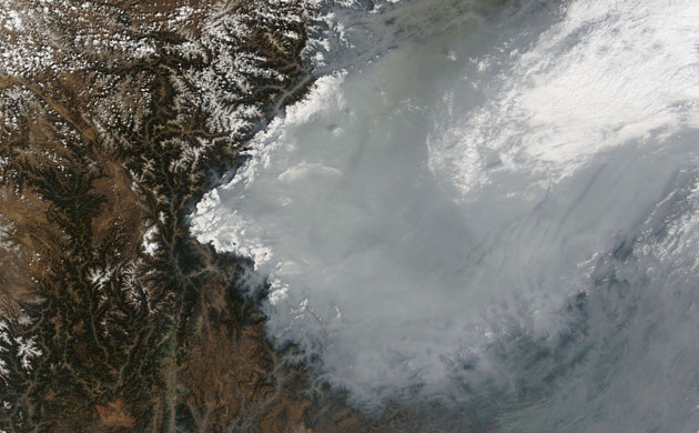
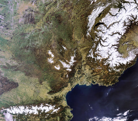
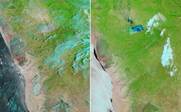
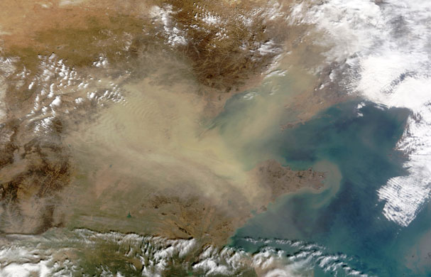
Nasa's Terra satellite captured thick haze clogging the air over China's Sichuan Basin on March 21. The haze probably results from urban and industrial pollution, with the cold air currents trapping pollutants at the surfacePhotograph: MODIS/NASAA cloud-free southern Europe, with Spain (lower left), France (centre), Switzerland (upper right) and Italy (lower right) all visible. Four mountain chains are clearly distinguishable – the Alps, Jura, Pyrenees and Massif Central. The western portion of the Alps is visible (bottom right) on the border of France and Italy. The Jura Mountains, north-west of the Alps, are also snow covered. The Pyrenees (bottom left) form the natural border between France and Spain (with the country of Andorra in between)Photograph: Meris/ESAThis composite image captured by the Terra satellite shows the effect of weeks of seasonal rain (left) which caused floods in northern Namibia. The right-hand image shows the region before the wet-season rains started in January 2009Photograph: NASA
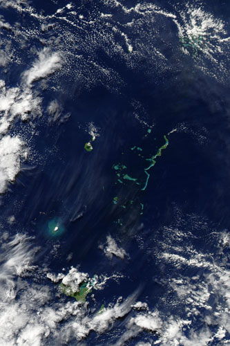
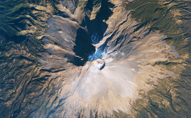
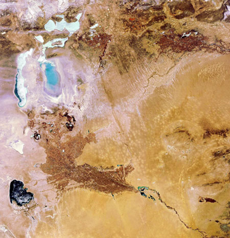
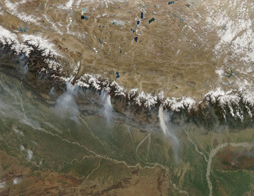
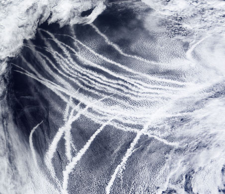
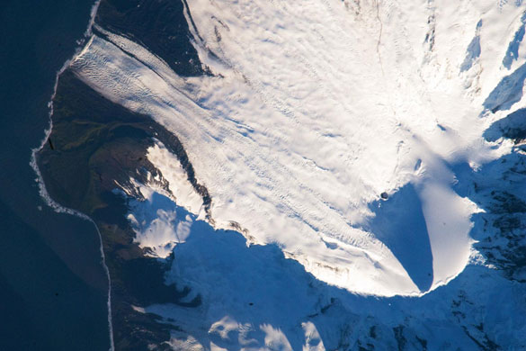
18 March 2009: Nasa's Aqua satellite captured this image of volcanic activity near Tonga in the South Pacific. The following day A submarine volcanic eruption occurred. The area around the eruption appears bright blue-green, likely resulting from ash and other volcanic debris suspended in the water. The brilliant white patch at the centre of the sediment-rich area may result from vapour released by the volcano. North-west of the eruption site, a serpentine-shaped brown ribbon probably indicates volcanic rock floating on the water.Photograph: Nasa14 March 2009: Wilson's Promontory National Park, located at the southern tip of Victoria, Australia, was one of many areas scorched by bush fires in February. The Cathedral Fire, which was sparked by lightning on 8 February, burned an estimated 25,200 hectares (62,271 acres) in the park before it was fully contained on 14 March. The image combines visible light with near-infrared light; the resulting false-colour image makes burned areas more obvious (charcoal-brown). Unburned vegetation is red, and areas where vegetation is naturally sparse, or dormant, are beige. Beaches and sandy spots are almost as white as the clouds. North of the park boundary (upper left), the landscape is beige and light red – a rural-agricultural area where people have cleared the natural vegetationPhotograph: Aster/Nasa15 March 2009: Nasa's Terra satellite captured this image of eastern China experiencing their first spring dust storm. Each spring, yellow dust migrates from China's interior to the nation's east coast. The dust forms an amorphous blob in this image, hiding part of the Bo Hai coastline, and completely obscures Beijing (slightly north-west of image centre). In 2005, scientists warned that China's dust storm season was getting worse for a variety of reasons, including desertification and human-exacerbated drought. From AD300 to 1949, north-western China experienced an average of one dust storm every 31 years. After 1990, the rate increased to a dust storm almost every yearPhotograph: Modis/NasaThis satellite image by Global Land Cover Facility/German Aerospace Centre shows the Laponian area in Sweden. The picture was part of an exhibition of XXL-sized satellite pictures of world heritage sites that opened in March outside the Unesco building in ParisPhotograph: HO/GLCF/DLR/AFP/Getty ImagesVolcan Popocatepetl, a large stratovolcano about 70km south-east of Mexico City, is considered by many volcanologists to be the planet's riskiest volcano. It is close to one of the most densely populated cities on Earth, with almost 23 million inhabitants. Potential volcanic hazards at Popocatepetl include explosive eruptions of ash, pyroclastic flows (hot, fluid avalanches of rock fragments and gas) and debris avalanches. This detailed astronaut photograph of the summit crater of Popocatepetl (image centre) also highlights the Ventorillo and Noroccidental glaciers. At the time this image was taken, steam and ash plumes were observed at the volcano. A faint white steam plume is visible against grey ash deposits on the eastern and southern flanks of the volcanoPhotograph: NasaThis image features an ice-covered Aral Sea, on the border between Kazakhstan and Uzbekistan in central Asia. Once the world's fourth-largest lake, the Aral Sea has been steadily shrinking over the past 50 yearsPhotograph: Envisat/ESA12 March 2009: Nasa's Aqua satellite caught a glimpse of a relatively rare event: large forest fires in the Himalaya mountains of Nepal. Places where the sensor detected active fires are outlined in red. The numerous small fires in southern Nepal may not be wildfires, but rather agricultural or other land-management fires. The image is centred on Nepal and it shows the towering Himalaya mountains arcing through the small country. Many national parks and conservation areas are located along the northern border of the country, and the fires appear to be burning in or very near some of them. However, conditions during the autumn and winter of 2008 and 2009 were unusually dry, and fires set by poachers to flush game may have raged out of controlPhotograph: Modis/NasaIn early March, the skies over the north-east Pacific Ocean were streaked with clouds that form around the particles in ship exhaustPhotograph: NasaHeard Island is located in the southern Indian Ocean, approximately 1,550km (963 miles) north of Antarctica. The island is a visible part of the Kerguelen Plateau, a submerged feature on the seafloor. The plateau was formed when large amounts of volcanic rock erupted over a geologically short time period. Most of Heard Island is formed from volcanic rocks associated with the Big Ben stratovolcano. The northeastern slopes of the volcano are visible in shadow at the lower right of this detailed astronaut photographPhotograph: NasaA relatively rare blanket of ice rested on the surface of Lake Superior on 3 March. In this true-color, photo-like image, ice floating on the surface of Lake Superior - the largest of the five great lakes of North America - ranges in colour from white to pale grey-blue. The ice appears most solid along the southern shore of the western half of the lake. North of that solid band of ice, cracks reveal deep blue lake waterPhotograph: Modis/Nasa
Sign up to read this article
Read news from 100’s of titles, curated specifically for you.