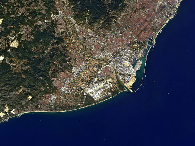
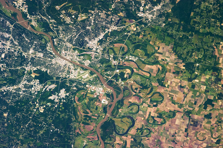
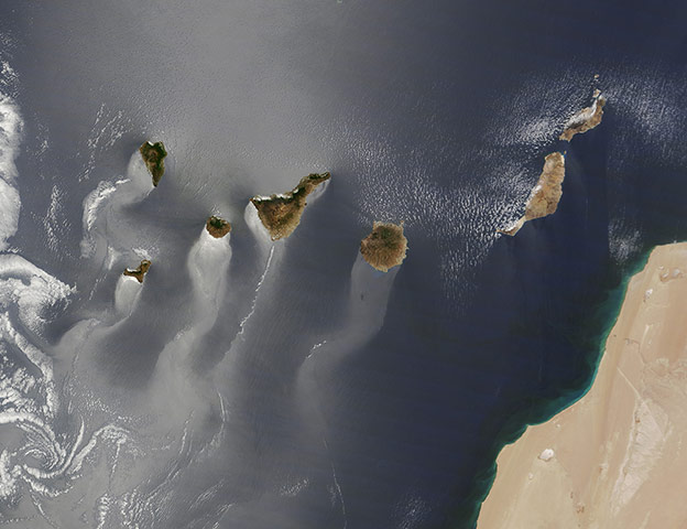
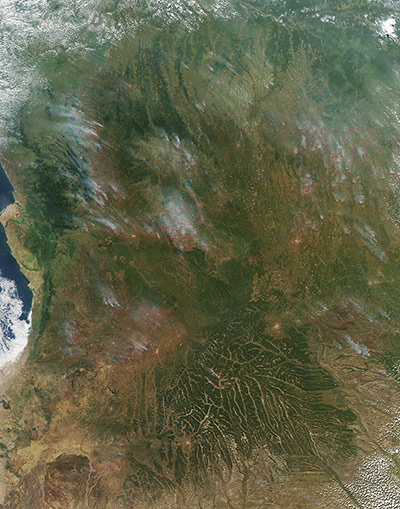
Barcelona, Spain: Near the top right corner, the circular Plaa de les Glories Catalanes was meant to be the city centre in the original urban plan. Dominating the left side of the image are the Garraf Massif mountains, their cliffs reaching the Mediterranean coast. Rock quarries and rubbish dumps are degrading the land here, and some of these degraded areas can be seen in the lower left corner as large yellow patches. Along the coast, we can see Barcelona's port, one of Europe's top 10 largest container ports. Barcelona-El Prat airport is about 10km southwest of the city centre, across the Llobregat River. On either side of the airport we can see the darker areas of the Llobregat deltaPhotograph: ALOS/JAXA/ESAThe capital city of Arkansas, Little Rock, occupies a position near the geographic center of the state. It sits between the eroded remnants of the Ouachita Mountains to the west, the Mississippi River alluvial plain to the east, and the West Gulf coastal plain to the south. The Arkansas River separates Little Rock on the south bank from North Little Rock on the north bank. Frequent changes in the position of the river channel through geological time are recorded as numerous oxbow lakes visible within extensive agricultural fields. Oxbow lakes are formed on river floodplains when wide meander bends are 'pinched off' due to the river cutting a shorter channel across the bend. The city of Little Rock takes its name from a small outcrop located on the south bank of the Arkansas River. This outcrop served as a landmark for navigating the river during the city’s early development as a center of regional commerce — a role the city still enjoys todayPhotograph: ISS/NASATrailing the Canaries: the play of light on water can reveal overlooked details and nuances to photographers and artists on Earth. The same thing can happen when looking from space. The Atlantic Ocean has a silvery or milky colour in much of the image, the result of sun-glint. Sunlight is being reflected off of the ocean surface directly back at the satellite imager, revealing details about the water surface or circulation that are otherwise invisible. In the image above, wavy, windsock-like tails stretch to the southwest from each of the islands. The patterns are likely the result of winds roughening or smoothing the water surface in different places. Prevailing winds in the area come from the northeast, and the rocky, volcanic islands create a sort of wind shadow — blocking, slowing, and redirecting the air flow. That wind, or lack of it, piles up waves and choppy water in some places and calms the surface in others, changing how light is reflected Photograph: MODIS/Terra/NASA
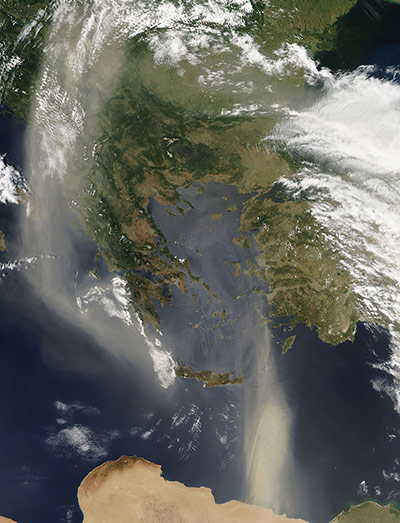
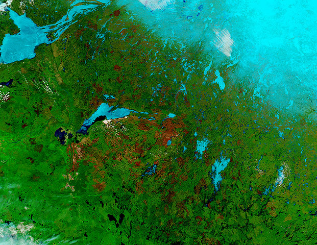
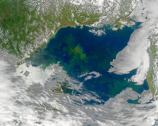
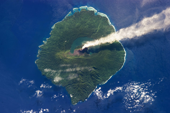
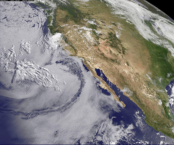
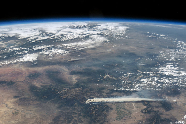
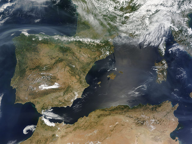
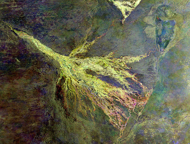
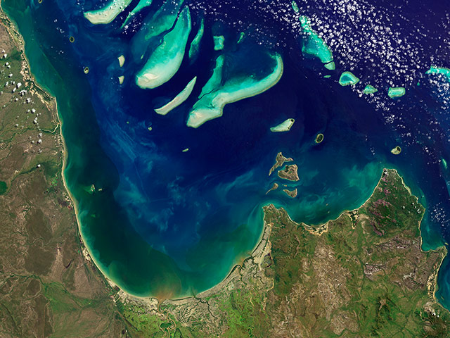
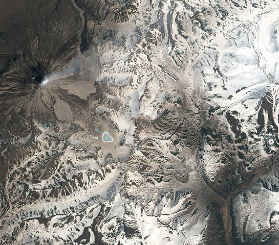
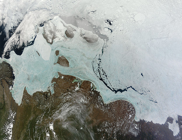
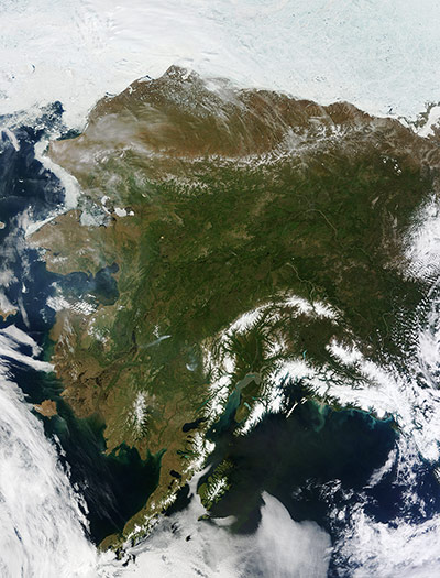
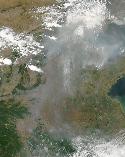
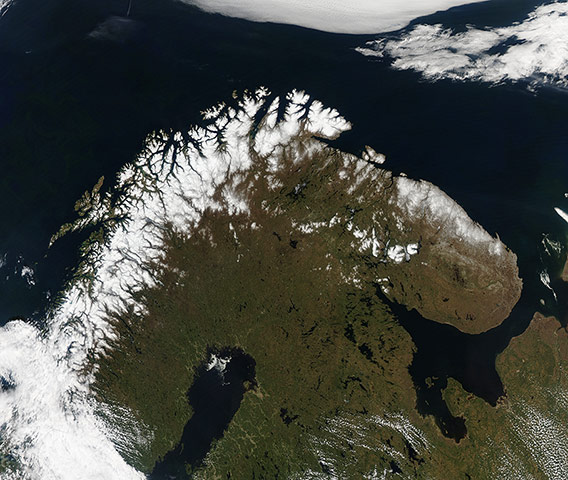
A strong Saharan dust storm covered the Mediterranean Sea and much of Europe in late May, bringing an extraordinary end to a very dusty month. Although the afternoon skies were largely cloud-free, much of the ground was shrouded from view from a thick layer of tan dust, particularly Albania, Montenegro, and Serbia. An arc of dust rolled from Libya over the Mediterranean Sea, stretched to southern Ukraine (north of this image), then curled south and eastward over the Black Sea. Dust storms are common in this region, and the fine particles move as if on a river of air across vast expanses, coming to rest in regions remote from their Saharan origin. African dust, originating from fine particles in arid topsoil, easily lifts in strong winds, and may rise more than 10,000 feet high. Dust clouds can cross the Atlantic, and may reach the Caribbean and the Americas in five to seven daysPhotograph: MODIS/Aqua/NASAJune 19: Striking images of smoke billowing from illegal wildfires on the Indonesian island of Sumatra. The smoke blew east towards southern Malaysia and Singapore, pushing pollution to record levels. Singapore’s primary measure of pollution, the pollutant standards index rose to 371, the highest level ever recorded. The previous record occurred in 1997, when the index hit 226. Though local laws prohibit it, farmers in Sumatra often burn forests during the dry season to prepare soil for new crops. Photograph: MODIS/Aqua/NASACanada: Wildfire is the dominant disturbance in the boreal forest, much of which is managed as a natural resource, covers much of northern Canada. According to statistics from Environment Canada, almost all of the boreal forests of the province of northern Saskatchewan have burned since 1945. In 2012 the fire season was especially intense, and in Ontario alone, it consumed 635,274 hectares. The five regions of Canada captured in this region include Northwest Territories (north), Nunavut (northeast), Alberta (west), Manitoba (east). Saskatchewan is in the center. In this false-color image, ice and snow are a bright blue, vegetation is bright green, and burned areas/open land appears tan. Recent fires scars appear a dark brown, because vegetation has burned away leaving open land Photograph: MODIS/Aqua/NASADifferently colored waters in the Sea of Okhotsk suggest differences in phytoplankton community structure from one location to the next. The ocean color community would eventually like to use remotely sensed data, such as are shown in the above Aqua-Modis image, to better understand global phytoplankton diversityPhotograph: MODIS/Aqua/NASAJust 12 miles (20km) in diameter, Gaua Island is actually the exposed upper cone and summit of a stratovolcano that is 3,000 meters high and 25 miles in diameter. Most of the volcano is submerged beneath the Pacific Ocean. Also known as Santa Maria Island, Gaua is part of the Vanuatu Archipelago, a group of volcanic islands in the South Pacific Ocean governed by the Republic of Vanuatu. This photograph records a steam emissions observed on May 31. The steam plume extends east-southeast from its likely source at Mount Gharat (also spelled Garat or Garet), a historically active cinder cone located along the southwest flank of a collapsed summit caldera. Gaua is one of several volcanoes monitored by the Vanuatu Geohazards ObservatoryPhotograph: ISS/NASAThe southern California 'June gloom' is a weather pattern that creates cloudy, overcast skies and cool temperatures. The low lying stratus clouds form over the ocean and can be pushed to coastal areas by wind. It usually happens off the west coast of California during the late spring and early summer. As for the 'seam' of blue within the 'June gloom,' it appears to be actinoform clouds, which are only marginally stable. Sometimes the cloud deck spontaneously dissolves along a line by drizzling out the moisture. This seam is an unusually long curve that is not identified with a coastline or a weather frontPhotograph: GOES-15/NOAA/NASAThe image shows a plume wafting from the West Fork Complex fire, which was burning explosively in southwestern Colorado near Pagosa Springs. To the northwest, a smaller plume from the Wild Rose fire is also visible. While the Wild Rose blaze was fully contained by June 25, the West Fork Complex was still raging through the San Juan and Rio Grande National Forests. The West Fork Complex is a combination of three fires: the West Fork fire, the Windy Pass fire, and the Papoose fire. Lightning ignited the first of the blazes on June 5, and together they had charred approximately 75,000 acres (30,000 hectares) by June 25. The fires were burning in rugged terrain with large amounts of beetle-killed spruce forests. The West Fork Complex fire was so hot that it spawned numerous pyrocumulus clouds — tall, cauliflower-shaped clouds that billowed high above the surface. Satellite observations also show that smoke reached European airspace by June 24Photograph: ISS/NASASmoke plumes hover over Spain and the western Mediterranean Sea. The smoke has a faintly yellow-tan or milky gray colour compared with brighter white clouds. Data from Nasa and other satellites suggests that the smoke originated from wildfires in Canada; it is less likely, but possible, that it came from wildfires in Colorado and other parts of the southwestern USPhotograph: MODIS/Terra/NASACompilation of three images showing where southwestern Africa's Okavango River empties into the inland Okavango Delta in northern Botswana. The Okavango River originates in Angola, forms part of the Angola-Namibia border and then ends in northern Botswana. Here, it has formed a depression in the semi-arid Kalahari basin. Appearing purple at the centre of the image is Chief's Island. In the lower-right portion of the image we can see a large cluster of radar reflections from the town of Maun. At the top of the image, a triangle with similar colouring to the delta can be seen. This is a swamp area and national park located mostly in NamibiaPhotograph: Envisat/ESAPrincess Charlotte Bay in Australia lies along the east coast of Queensland’s Cape York Peninsula. The image shows Claremont Isles national park, where coastal waters are protected as part of Great Barrier Reef world heritage site. The islands are important habitat and breeding grounds for seabirds, and they are off-limits to humans. Near the coast, weather patterns, natural aerosols, air pollutants, waves and currents, and floating material can distort, reflect, and refract light signalsPhotograph: OLI/Landsat 8/NASASpring has arrived at Kizimen Volcano. The mountainous landscape is covered in a patchwork of snow, ash, volcanic debris, and still-dormant vegetation. Instead of being white, the snow is dark brown, covered by layers of ash that were trapped by a succession of winter storms. As the snow melts, layers of ash that were deposited individually start to combine, resulting in a thick blanket of ash on top of the remaining snow. Bare rock and volcanic debris are also brown, but lighter than the ash-covered snow Photograph: EO-1/ALI/NASAA dramatic look at the progress of the spring sea ice melt in the Sakha region on June 16. In the lengthening sunlight and warming temperatures, snow has retreated from the arctic tundra of the Sakha (Yakutia) Republic, a vast land of 3,083,523 sqkm and a population of less than 1 million. About 40% of Sakha lies above the Arctic Circle. Near the center of the image, the New Siberian Islands retain a wind-blown snow cover, and are surrounded by the icy waters of the Laptev Sea (west) and East Siberian Sea (east), which remains covered with ice, but it is fragmented and light in color, looking much like chunky slush. These seas are ice-covered for 9-10 months of the year, with ice minimums normally reached in August, just in time for shortening sunlight and plummeting temperatures to begin to re-freeze the frigid watersPhotograph: MODIS/Terra/NASAOn most days, relentless rivers of clouds wash over Alaska, obscuring most of the state’s 6,640 miles of coastline and 586,000 sq miles of land. The south coast of Alaska even has the dubious distinction of being the cloudiest region of the United States, with some locations averaging more than 340 cloudy days per year. But on June 17, snow-covered mountains such as the Alaska Range and Chugach Mountains were visible in southern Alaska, while the arc of mountains that make up the Brooks Range dominated the northern part of the statePhotograph: MODIS/Terra/NASAUnprecedented rainfall and flooding continued to plague central Europe in mid-June, causing billions of dollars in damage. The Elbe, Danube, Saale, and other river systems rose well above their banks and breached flood defenses in Germany, Austria, the Czech Republic, Hungary, and Slovakia. The image above shows flooding near Wittenberg, in the German state of Saxony-Anhalt Photograph: Landsat 8/NASAMultiple plumes of smoke from agricultural fires and industrial pollution in China. The smoke and haze stretches from Inner Mongolia, located north of Beijing, south and west including the provinces of Hebei, Shedong, Henan, Shanxi, Hubai, Hunan, and Chongqing. This image was captured on June 2. In this true-color image, fires (hot spots) are color coded as red areas in imagery and smoke appears in light brownPhotograph: MODIS/Aqua/NASAHundreds of fires burning in Angola fires are marked in red, and most appear to burn in grass or cropland. Farmers often use fire to return nutrients to the soil and clear the fields for planting. In this region, about 80% of farmers are small holders, cultivating a very small plot of land and these plots have had very low productivity since civil war ravaged the nation.While fire helps in planting crops, clearing fields and renewing pasture, it brings a cost. Smoke decreases air quality, and can cause a number of respiratory problems in both animals and humansPhotograph: MODIS/Aqua/NASALate spring in Scandinavia brings warming temperatures, blooming flowers and longer days. Snow covers the Scandinavian Mountains (also known as the Scandes), the steep range that forms the border between Norway and Sweden. The precipitous western slope drops into the Norwegian Sea, creating rugged, picturesque fjords. Most of Norway is mountainous, with only 10% of its land arable. The eastern slope of the Scandes descends into greener land in Sweden, which, in the north, abounds with subarctic peatlands and lakes. The Gulf of Bothnia separates northern Sweden from southern Finland. In northern Finland the Scandes still carry a dusting of snow, but are no longer the steep, majestic peaks found further south. In the far east (right) of the image, the greening land belongs to Russia. In the north, the Kola Peninsula is bordered by the Barents Sea (north) and the White Sea (south). This Peninsula, which is part of Murmansk Oblast, sits almost entirely within the Arctic CirclePhotograph: MODIS/Aqua/NASA
Sign up to read this article
Read news from 100’s of titles, curated specifically for you.