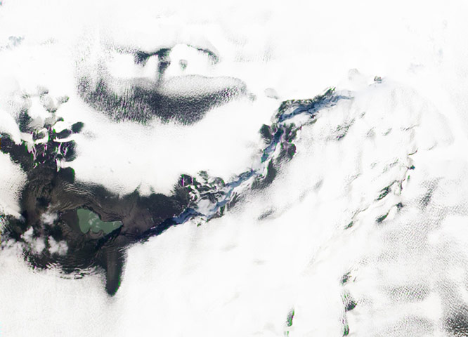
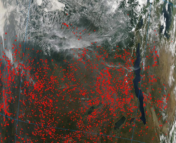
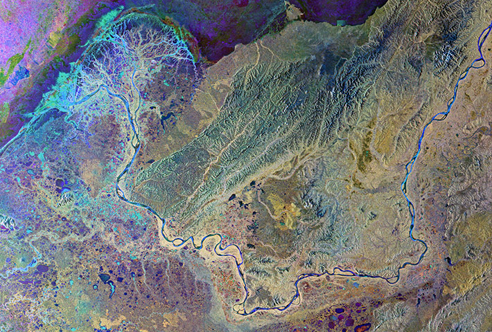
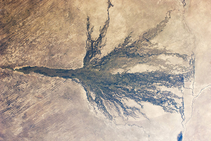
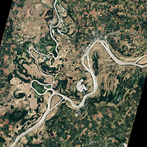
After covering a large portion of Iceland with ash in late May 2011, Grímsvötn volcano left behind a small lake filled with meltwater and a hole in the Vatnajökull glacier on 11 June, 2011. The lake covers much of the site of the eruption, with the possible exception of the crescent-shaped feature along the southern shore of the lake. This may be a tephra cone left behind by the eruption. Grey ash covers the ice of the glacier near the vent. Further away, the ash layer itself is obscured by snowPhotograph: ALI/EO-1/NASANasa's Aqua satellite and the moderate resolution imaging spectroradiometer instrument onboard captured this image of fires in central Africa. Most of the fires (seen as red dots in this image) are occurring in the Democratic Republic of the Congo (DRC), left of Lake Tanganyika, one of the largest freshwater lakes in the world. Lake Tanganyika is bordered by four countries: Burundi, the DRC, Tanzania and Zambia. The image also shows fires burning in Burundi, located to the north-east (right) of the lake and Rwanda, north of BurundiPhotograph: MODIS/Aqua/NASAThis Envisat image features Alaska's Yukon delta, where the Yukon river fans out into a labyrinth of distributaries before emptying into the Bering Sea. The Yukon, North America's fifth-longest river system, flows some 3,190km across central Alaska in the US before emptying into Norton Sound (top left). This image was created by combining three Envisat radar acquisitions over the same area. The colours represent changes in the surface between acquisitionsPhotograph: ASAR/Envisat/ESA
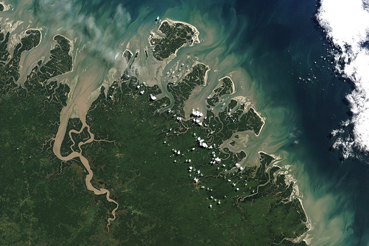
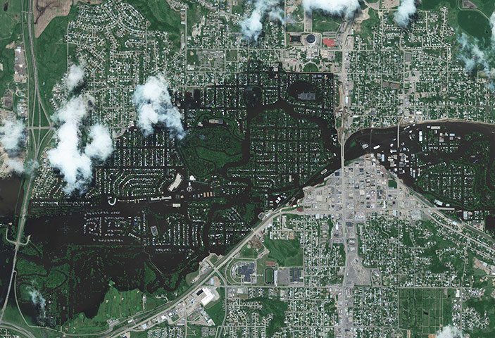
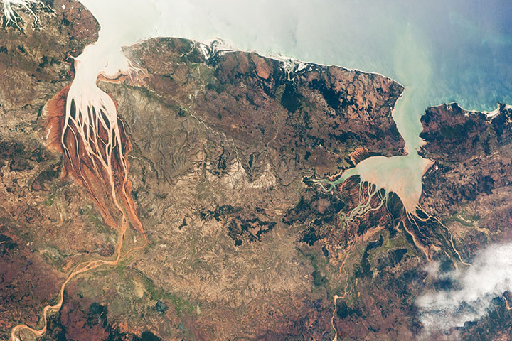
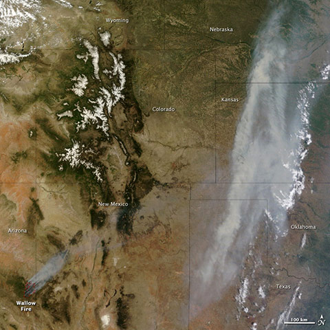
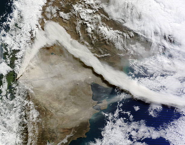
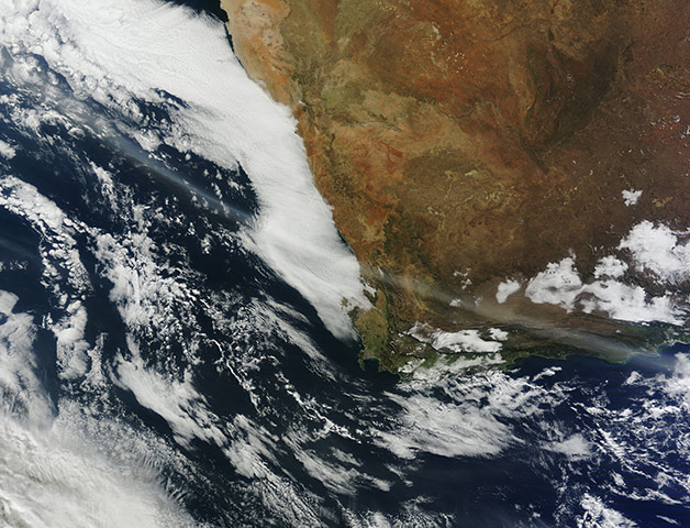
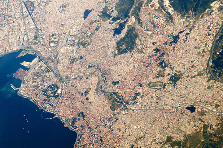
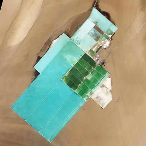
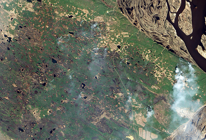
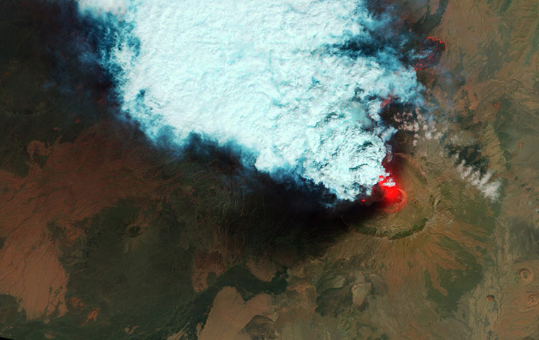
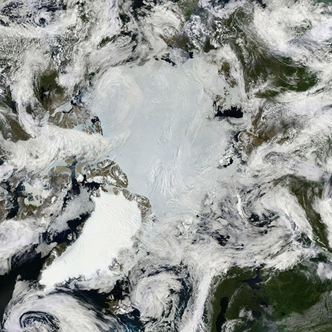
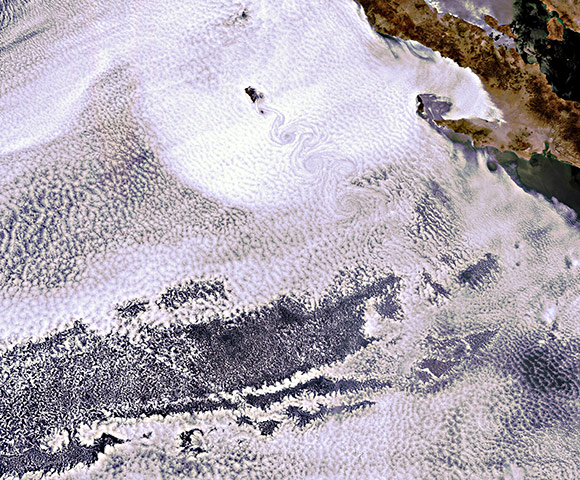
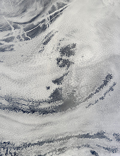
Barrier islands along the north-east coast of Brazil, midway between the mouth of the Amazon river and the coastal city of São Luís. They are narrow strips of sand, often spits or sandbars that grew into full-blown, vegetated islands. They stretch from a few hundred metres to several kilometres wide. They run parallel to the coast, facing the sea and bearing the brunt of waves and wind, while protecting the lagoons and bays and coastal wetlands behind them. Shaped and reshaped by currents, tides, winds, and man, they move almost constantly. Barrier islands are found along the edge of every continent except Antarctica, and in 2011 scientists and naturalists are still finding new ones. According to the research team, Brazil has the world’s longest continuous chain of barrier islands - 54 in total, extending more than 571km (355 miles) along the Atlantic coastPhotograph: Landsat/NASAThis short focal-length astronaut photograph shows the entire Okavango delta, a swampland in southern Africa known as the 'jewel of the Kalahari desert'. This enormous, pristine wetland almost miraculously appears in a desert, where surface water is typically non-existent. The water comes from the Okavango river, which rises in the high-rainfall zone of southern Angola, hundreds of kilometres to the north-west. The dark-green forested floodplain is about 10km (6 miles) wide where it enters the view (in the left of the image). The Okavango then enters a rift basin, which allows the river to spread out and form the wetland. The width of the rift determines the dimensions of the delta—150km (90 miles) from the apex to the downstream margin (image right)Photograph: ISS/NASAThis satellite image taken on 25 June shows flooding due to the cresting of the Souris river in Minot, a city north central North DakotaPhotograph: GleoEye/APTwo estuaries along the north-west coast of Madagascar, where the Mozambique Channel separates the island from the south-eastern coast of Africa. Bombetoka Bay (image upper left) is fed by the Betsiboka river, and is a frequent subject of astronaut photography due to its striking red floodplain sediments. Mahajamba Bay (image right) is fed by several rivers, including the Mahajamba and Sofia. The hardy shrubs and trees of mangroves are common in and around Madagascar’s estuaries, and Bombetoka Bay contains some of the largest remaining stands. Estuaries also host abundant fish and shellfish species, many of which need access to fresh water for a portion of their lifecycles. In turn, these species support local and migratory bird species that prey on them. However, human activities such as urban development, overfishing, and increased sediment loading from erosion of upriver highlands threaten the health of the estuariesPhotograph: ISS/NASAHigh winds and low humidity fueled extreme fire behaviour as the Wallow Fire continued to consume acres of forested land in the mountains of eastern Arizona on 7 June, 2011. By the end of the day, the fire had burned 311,481 acres (487 square miles), up 77,959 acres (122 square miles) from the previous day. As the fire raged, smoke poured across the United States, clouding skies over the midwestPhotograph: MODIS/Terra/NASAThe confluence of the Wabash and Ohio rivers on 23 June, 2011. The spring floods in the Mississippi river basin extended to the confluence of the two rivers in the southwestern corner of Indiana, pushing the rivers over their banks. By early June, flooding had largely receded, and by late June 2011, little flooding remained. Both rivers, as well as Hovey Lake, appear silver-grey in this image, probably due to the reflection of sunlight off the water surface (sunglint). Away from the water, the land is a patchwork of croplands shaped by human design, and floodplains shaped by overflowing riversPhotograph: ALI/EO-1/NASAAfter awakening on 4 June, 2011, the eruption at the Puyehue-Cordón Caulle volcano continued until 6 June. Located in Chile, just west of the border with Argentina, the volcano emitted a plume of light-coloured ash that stretched along the edge of the Andes. Hours earlier the prevailing winds had shifted, forming the prominent kink visible in the plume, captured in this natural-colour satellite imagePhotograph: MODIS/Terra/NASAA wide ribbon of brown volcanic ash passed over South Africa from the Puyehue-Cordón Caulle, which erupted more than 4,800 miles away in Chile. Within 48 hours of eruption, the plume was measured at 15km (50,000 feet) above the Earth, high enough to pass above the weather that usually breaks up lower lying ash plumes. By 13 June, the plume crossed Australia and New Zealand, causing air traffic to be cancelled or diverted to lower altitudes than normal to avoid the volcanic ash, which can damage a jet enginePhotograph: MODIS/Terra/NASALocated in the western Anatolia region of Turkey, Izmir is the country’s third most populous city and its second largest port (after Istanbul). This astronaut photograph highlights the modern urban landscape of the Izmir metropolitan area. Densely built residential and commercial districts, characterised by grey to reddish gray rooftops, occupy much of the centre of the imagePhotograph: ISS/NASALocated in China’s resource-rich but moisture-poor Xinjiang autonomous region, Lop Nur is an uninviting location for any kind of agriculture. It sits at the eastern end of the Taklimakan desert, where marching sand dunes can reach heights of 200m (650 feet), and dust storms rage across the landscape. Yet for all it lacks in agricultural appeal, Lop Nur offers something valuable to farmers the world over: potash. This potassium salt provides a major nutrient required for plant growth, making it a key ingredient in fertiliser. The discovery of potash at Lop Nur in the mid-1990s turned the area into a large-scale mining operation. The rectangular shapes in this image show the bright colours characteristic of solar evaporation ponds. Around the evaporation ponds are the earth tones typical of sandy desertPhotograph: ALI/EO-1/NASADeep green needle-leaf forests stretch away from the Lena river in Russia’s remote eastern reaches. Siberian larch trees mingle with patches of fragrant pine, while brush and moss cling to the ground. Unlike most coniferous trees, the larch sheds its needles at the end of the year, coating the forest floor with a flammable layer of dry, yellow kindling. When winter’s snow melts away and the ground dries out, the larch forest is very prone to fire, particularly in May and June. The land is faintly charred, and smoke pours from the edge of the burned area where the fire was still active. The fire in this image is one of many that swept through the boreal forests of far eastern Russia in late May and early JunePhotograph: ALI/EO-1/NASASince it began erupting on 12 June, emissions from Eritrea's Nabro volcano have drifted over much of east Africa and the Middle East. Ash has displaced residents living near the volcano and disrupted flights in the region. Despite the volcano's widespread effects, little is known about the eruption. Nabro is located in an isolated region along the border between Eritrea and Ethiopia, and few English-language reports have been published. Satellite remote sensing is currently the only reliable way to monitor the ongoing eruptionPhotograph: NASAOn 30 June, the spectroradiometer aboard Nasa’s Terra satellite made multiple passes over the Arctic, capturing a true-colour image of the summer lands and sea-ice near the north pole. In this mosaic of the Arctic, the polar ice cap appears blue-white, while the ice covering land appears bright white. The ice of Greenland, in the lower left (south-west), is especially bright. Clouds also appear bright white, and can be difficult to separate from ice in true-colour imagesPhotograph: GSFC/Jeff Schmaltz/MODIS Land Rapid Response Team/NASAThe volcanic island of Guadalupe peeking through the clouds on June 15. The island lies in the Pacific Ocean around 250km off the west coast of Mexico's Baja California peninsula. The swirling clouds to the south of the island are the result of a meteorological phenomenon known as a 'von Karman vortex'. As wind-driven clouds encounter Guadalupe, they flow around the high volcanic outcrop to form the large spinning eddies that can clearly be seen in the imagePhotograph: Envisat/ESAOn 1 June, 2011, a supercell thunderstorm developed over western Massachusetts. The storm produced an EF3 tornado that cut a 39-mile (63km) track of destruction across south-west and south-central MassachusettsPhotograph: Landsat/NASAThe summer skies over the Pacific Ocean off the coast of Baja California were filled with a spectacular pattern of open-cell and closed-cell clouds on 22 June, 2011. In this image, clouds appear to be formed in cell-shaped structures that resemble compartments in a honeycomb. The majority of the cells are fully filled with puffy white clouds, giving the cloud deck a textured appearance from space. These clouds, with full cells, are called 'closed-cell clouds'. In contrast, in some areas only the lacy structure can be seen, while the centre of the cells appears to be empty. These are open-cell cloudsPhotograph: MODIS/Terra/NASA
Sign up to read this article
Read news from 100’s of titles, curated specifically for you.