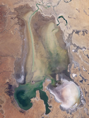
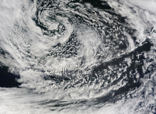
A Japanese satellite captured this image of a partly man-made island in the Persian Gulf, some 25 nautical miles north-west of Abu Dhabi Photograph: ALOS/ESAAustralia's Lake Eyre is the fifth largest terminal lake in the world, with a drainage basin stretching 1.2 million km sq from the Northern Territory to South Australia. The lake is mainly dry except in the wake of a rare, steady rainy season. This was the case in early 2009, when intense rains fell over northern Australia. A total of 17m megalitres of water flowed into the lake - which has no outlet - soaking into the soil and sustaining grasses. By June 10, when this satellite image was captured, the flow of water had slowed: Lake Eyre was as full as it was going to get in 2009Photograph: Landsat/NASAThe cloud patterns seen in this image resemble the V-shaped wake left by objects moving through water. The pattern is not coincidental; wind behaves like a fluid, so when it encounters an obstacle, it must move around it, leaving behind a wake or a visible wave pattern. In this case, the obstacle is an island in the chain of the Aleutian Islands, which extend westward from AlaskaPhotograph: MODIS/NASA
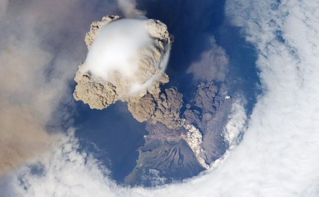
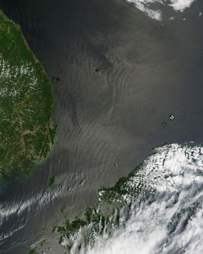
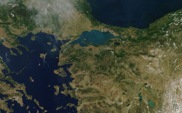
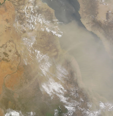
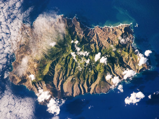
On 12 June, Sarychev Peak, a stratovolcano covering almost the entirety of Matua Island in the Kuril Islands, Russia, experienced a spectacular eruption which transformed the island. Acquired by the thermal emission and reflection radiometer technology on Nasa's Terra satellite, these images show the island shortly after the eruption on 30 June. Vegetation appears red, water appears dark blue, and clouds, water vapour and ice all appear whitePhotograph: ASTER/NASAThe International Space Station captured this detailed astronaut photograph of the eruption of Sarychev volcano on 12 June which shows several phenomena that occur during the earliest stages of an explosive volcanic eruption. The main column is one of a series of plumes that rose above Matua Island, where the volcano is situated. The plume appears to be a combination of brown ash and white steam. The vigorously rising plume gives the steam a bubble-like appearancePhotograph: ISS/NASAThe devastating drought that gripped Iraq in the 2007-08 growing season continued into 2009. This image reflects the condition of plants growing throughout the region during April. Areas that are brown show where plants were growing less than they did on average between 2000 and 2008. Green areas show better-than-average growth, and tan areas reflect average conditions. The most affected area is northern Iraq, the country's historical breadbasket, where rain-fed wheat is grown. The drought has also limited water supplies available to farmers through the Tigris and Euphrates rivers, which flow into Iraq from Turkey and SyriaPhotograph: MODIS/NASAThis image, captured on 11 June, shows an interesting phenomena called "internal waves" occurring in the southern part of the Sea of Japan. South Korea is to the west, and Japan to the south-east. Internal waves are waves that occur underwater at the boundary between layers of water with different densities. Like all major bodies of water, the Sea of Japan is composed of layers of water with different densities: the topmost is the least dense, while each successively deeper layer is denser. Internal waves are usually caused by the lower layer being forced against a shallow obstacle, such as a ridge, by tidal action. The ridge causes a disturbance, which creates a wave in the water layer, similar to the way that the wind can cause waves on the water's surface. Unlike normal surface waves, internal waves can stretch for tens of kilometres in length and move throughout the body of water for several daysPhotograph: MODIS/NASAFogo (fire) is an apt name for this imposing volcanic island. One of the Cape Verde Islands, located roughly 640km off the western tip of Africa, Fogo received its name from Portuguese colonists around 1500. The volcano is said to have been almost continuously active from that time until about 1760. This image from June 10 shows the volcano's most distinctive feature, the 9km-wide caldera, Cha CalderaPhotograph: NASAThe region around the Aegean Sea is shown in this image, captured on 6 June. The large, light-colored body of water near the centre of the image is the Sea of Marmara, located in Turkey. An inland sea, it is connected to the Aegean in the west by the Dardanelles strait, and to the Black Sea in the east by the Bosphorus strait. The sea is not always light-coloured - this is being caused by a seasonal bloom of phytoplankton (tiny marine plants)Photograph: MODIS/NASAA dust storm over the Red Sea continued into early July, appearing as a huge beige blur that almost completely covers the Red Sea, and extends all the way to Saudi ArabiaPhotograph: MODIS/NASASaint Helena Island, located in the South Atlantic, was one of the many isolated islands that naturalist Charles Darwin visited during his scientific voyages in the 19th century. He visited the island in 1836 aboard the HMS Beagle, recording observations of the plants, animals, and geology that would shape his theory of evolution. This image was acquired by astronauts as part of an ongoing effort called the HMS Beagle project to document current biodiversity in areas visited by Charles Darwin. It shows that human presence on the island has also caused dramatic changes to the original plants and animals of the island. Only about 10% of the forest cover observed by the first explorers now remains in a semi-natural state, concentrated in the interior highlandsPhotograph: ISS/NASAOn 29 June, Nasa and Japan's Ministry of Economy, Trade, and Industry released the most extensive satellite-based topographic model of Earth to date. Created using data from the thermal emission and reflection radiometer, which flies on Nasa's Terra satellite, the data compliments previous digital elevation information available from the shuttle radar topography mission. The towering peaks of the Himalayas provide an illustration of the strengths of the new model in measuring steep terrain. Scientists flew a radar on the space shuttle and were able to determine elevations by measuring the echo that returned after the radar waves bounced off the surface of the Earth. Everest, Lhotse, and Makalu, the highest peaks in the region are seen in the centre of this viewPhotograph: ASTER/NASA
Sign up to read this article
Read news from 100’s of titles, curated specifically for you.