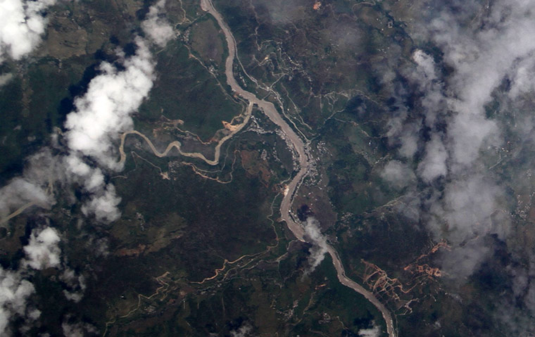
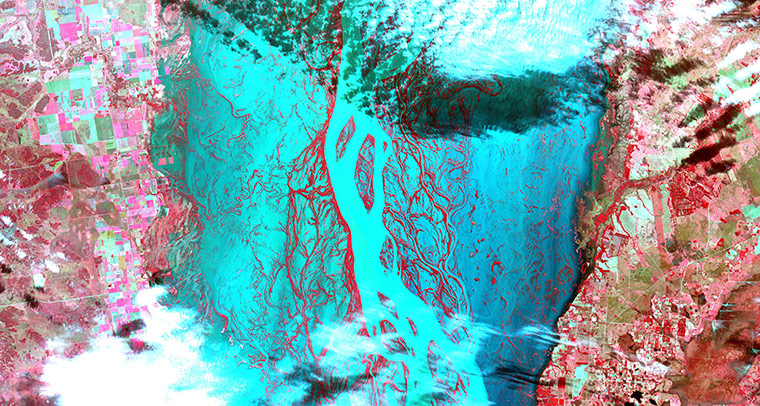
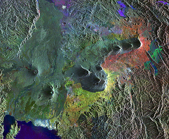
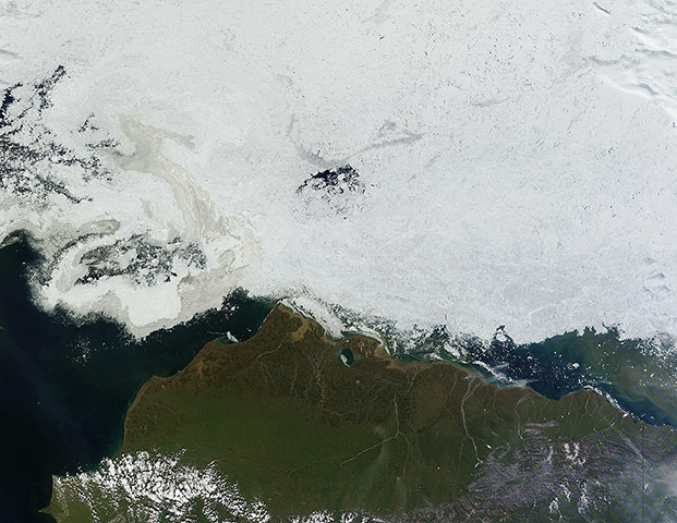
Exceptional, early monsoon rains in northern India and Nepal combined with melting snow to bring horrific flooding and landslides to the region in June. According to relief agencies, more than 1,050 people died, thousands more went missing, and hundreds of thousands had their lives disrupted. Indian government reported 744 villages and hamlets had been partially or completely cut off from the rest of the country with no access to water, power supply or roads. India’s Mandakini River, above, near the village of Tilwara in Uttarakhand state still appears to be swollen, though deposits of chalky gray and tan sediments also make the banks difficult to discern from the river itselfPhotograph: ISERV Pathfinder/ISS/NASAHeavy rains, which began in mid-June, have resulted in major flooding along the Parana River in Argentina. Thousands of people have been forced to evacuate their homes in cities along the river. The neighboring countries of Paraguay, Uruguay and Brazil have also been affected. Vegetated areas are shown in shades of red; the river and flooded areas are blue and turquoise; clouds are white and light bluePhotograph: ASTER/NASAThis Envisat radar image features a chain of volcanoes called the Virunga Mountains that stretch across Rwanda's northern border with Uganda and east into the Democratic Republic of the Congo. The area pictured is part of the Albertine Rift, one of Africa's most biologically diverse regions. The combination of high human population density, poverty and conflict poses a challenge to conservation. National parks have been established across the mountain range to protect the fauna and floraPhotograph: ENvissat/ESA
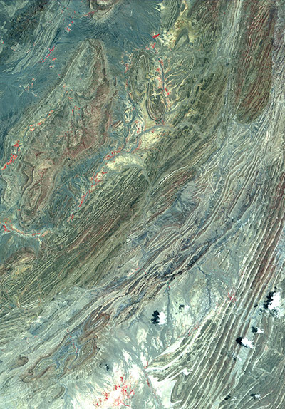
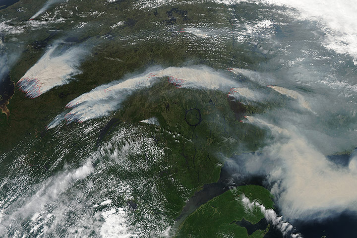
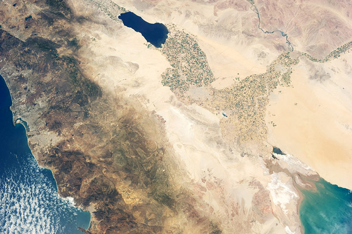
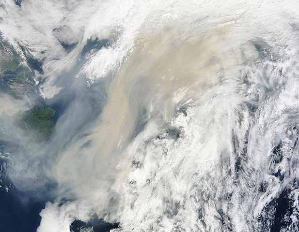
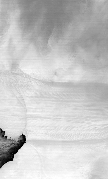
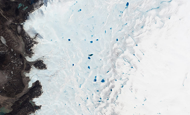
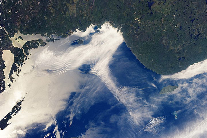
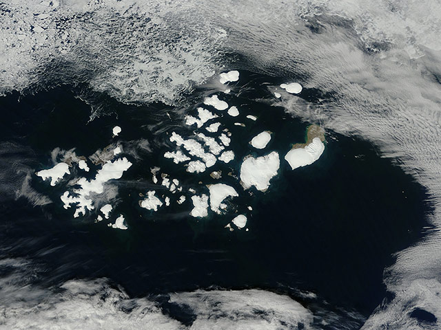
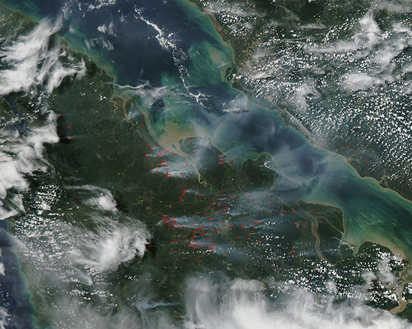
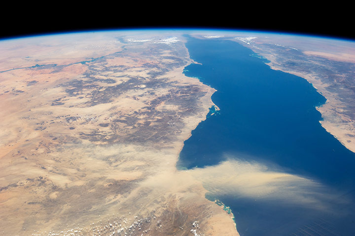
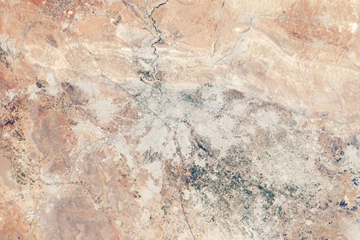
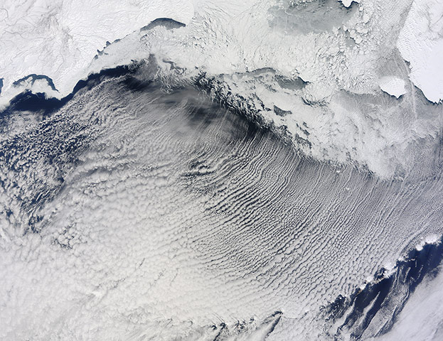
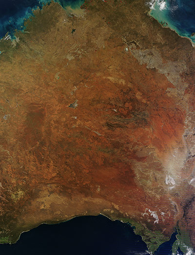
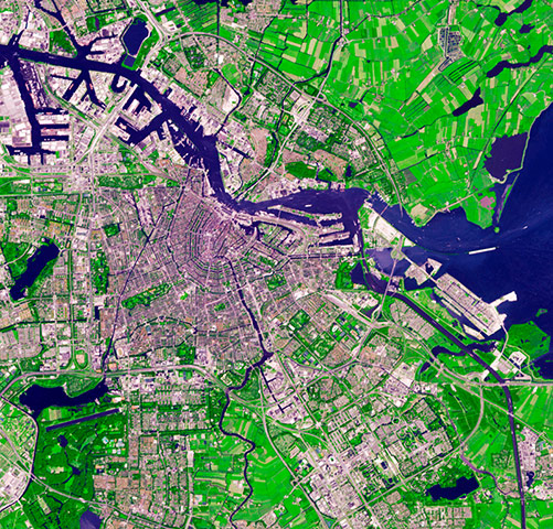
The town of Kirkenes in northernmost Norway, with its 3,400 inhabitants, is preparing for an expected boom as a shipping hub, as global warming has led to the opening of the North Sea route along Russia's Arctic coastline. The travel time between Tokyo and Hamburg, for example, has been cut by 40% – and 10 to 15% of Chinese international trade could take this route by 2020Photograph: ASTER/NASAThe Sulaiman fold-thrust belt in northwestern Pakistan is a linear or arcuate belt in which compression has produced a combination of thrust faults and folds. The belt is located on the northwest margin of the Indian tectonic plate, and was formed as India crashed into the Asian continent. The fold belt is the most prolific hydrocarbon province of Pakistan Photograph: ASTER/NASAWildfires burn in western Quebec near James Bay on 4 July. Red outlines indicate hot spots where satellites detected unusually warm surface temperatures associated with fire, and smoke from the fires moving across the Atlantic Ocean. By 8 July, smoke was drifting over ScandinaviaPhotograph: MODIS/Aqua/NASAThe Imperial and Coachella valleys of southern California, and the corresponding Mexicali Valley and Colorado River Delta in Mexico, are part of the Salton Trough. This large geologic structure, known to geologists as a graben or rift valley, extends into the Gulf of California. Sediments deposited by the Colorado River have been filling the northern rift valley (the Salton Trough) for several million years, excluding the waters of the Gulf of California, and providing a fertile environment for the development of extensive, irrigation-aided agriculture in the region (visible as green and yellow-brown fields at centre of the image). The Salton Sea, a favorite landmark of astronauts in low-earth orbit, was formed by the rupture of an irrigation canal in 1905 and is now sustained by agricultural runoff waterPhotograph: ISS/NASAA thick river of smoke curls across the Atlantic Ocean on 6 July. In the west of the image, the green land of Canada can be seen, most of which is covered by a thin grey haze. A thick veil of smoke obscures much of southern Canada, and this tan-gray veil blows to the east, then to the northeast. The colour of the smoke appears both tan and gray, and is stretched into brush-stroke like curves across the ocean, which disappears from view under the smoke. The smoke filled plume is so high that it even hides the bright white clouds from view as it travels over them. Fires have been burning across Canada since early June, especially in Manitoba and Quebec. Rain in Quebec on 5 July helped diminish the fires there, although a severe fire was ignited when a freight train carrying oil derailed in the small, picturesque town of Lac-Megantic and poured thick smoke into the skiesPhotograph: MODIS/Terra/NASAThe foothills of the Andes mountains near the southern coast of Peru. The Andes stretch about 4,350 miles from Venezuela down South America's west coast to the top of Argentina. The mountain rage is the result of the Nazca and Antarctic tectonic plates moving under the South American plate, a geological process called subduction. This process is also responsible for the Andes range's volcanic activityPhotograph: KARI/ESAAlaska’s North Slope, which sits almost entirely above the Arctic Circle, is a land of rich resources and rapid change. Home to a half a million migratory caribou, polar bear, grizzly bear, and offering breeding grounds to a host of migratory bird species, the sensitive tundra ecosystem also is home to huge oil reserves. In addition, this unique ecosystem lies in an area where the climate is warming as fast as anywhere in the world. It is a delicate, beautiful land that has changed over the past decades, and is predicted to change more rapidly in the future. To the south dark yellow-green taiga covers the mountains of the Brooks Range, which serves as the source of many of the braided rivers that carry snowmelt to the Chukchi Sea (west) and Beaufort Sea (east), which are both marginal seas of the Arctic Ocean. These frigid waters contain free-floating sea ice, even in mid-summerPhotograph: MODIS/Terra/NASAThe longest and fastest moving glacier in west Antarctica calved a new iceberg in July with two widening cracks along an edge of the Pine Island Glacier in Antarctica. To the west of the cracks — in the image, north is to the upper right — a new 280-sqmile ice island was formedPhotograph: ASTER/Terra/NASASpringtime introduces a new palette to the icy, white landscape of Greenland. Pools of blue water begin to dot the surface of the ice sheet as the top layer of snow and ice melts. The ponds provide an important indicator of how much the ice sheet is melting in a given year. In 2013, melt ponds were initially slow to appear along the edge of the ice. The first pools were visible in early June. Meltwater accumulates as pools in depressions in the ice, and the extent and depth of these ponds and the rate at which they grow and shrink tells scientists how quickly the ice is melting. Despite the late start, melting in 2013 has been rapid, occurring at a faster pace than the 1981-2010 averagePhotograph: NASAAt the top of the image, the Canadian Shield of southern Ontario is covered by an extensive forest canopy typical of early summer. Offshore and to the west and southwest of Pukaskwa national park, several distinct sets of parallel cloud bands are visible. Gravity waves are produced when moisture-laden air encounters imbalances in air density, such as might be expected when cool air flows over warmer air. The second phenomenon — sunglint — affects the water surface around and to the northeast of Isle Royale. Sunglint is caused by light reflection off a water surface; some of the reflected light travels directly back towards the observer, resulting in a bright mirror-like appearance over large expanses of water. Water currents and changes in surface tension — typically caused by presence of oils or surfactants — alter the reflective properties of the water and can be highlighted by sunglintPhotograph: ISS/NASAThe clouds opened over Franz Josef Land, allowing a clear view of the ice-capped archipelago, on 19 July. Located 560 miles from the North Pole, Franz Josef Land is one of the most remote areas on Earth. It is home to polar bears, walrus, seals, whales and multitudes of seabirds, but no humans call these islands home. It is an archipelago of six main and 135 small islands with a total landmass of about 6,229 sq miles. Totally covered in snow and ice in winter, in midsummer up to 5% of the land is covered in vegetation, and 85% of the land remains covered with glaciers. The glaciers are in retreat, however, and many of the islands in this image can be seen to be partially free of snow and ice. In 2009 Russia designated Franz Josef Land as well as the northern part of Novaya Zemlya Archipelago and Victoria Island as the Russian Arctic national parkPhotograph: MODIS/Terra/NASALand-clearing blazes continued to dot the landscape of Indonesia in July. Fires for clearing land have been outlawed for all but the smallest landowners, yet the traditional use of fire for agricultural management continues in this regionPhotograph: MODIS/Aqua/NASAA panoramic view of the Red Sea with the Nile River snaking its way northward through the Sahara desert on the left. Much closer to the camera is a dust plume surging out over the Red Sea and reaching most of the way to Saudi Arabia. The source of this plume is the delta of Khor Baraka, a river system which originates in Eritrea as Barka River. Astronaut images have shown that this delta is a common source for dust plumes, mainly because it is a large area of exposed, loose sand and clay that can be easily lofted into the air. The river also cuts a narrow valley through a high range of hills that channels the wind, making it blow fasterPhotograph: ISS/NASADamascus, capital of Syria, is one of the oldest cities in the Middle East, with evidence of human habitation extending back to 8,000–10,000 BC. During medieval times, the city was well known as a craft and trade centre, specialising in the production of swords and lace. 'Damascus steel' became a watchword for high-quality blades through the 19th century due to its superior properties and characteristic appearance. The Barada River runs through Damascus, entering the metropolitan area at image top-centre. The Ghouta Oasis, fed by the Barada River, once encircled Damascus; but urban expansion has converted much of the oasis from agriculture to other land uses. A large region of agriculture extends to the southeast of the city, visible as extensive green fieldsPhotograph: ISS/NASAClouds stretch in parallel rows for hundreds of miles over the Bering Sea. The parallel clouds, known as cloud streets, originated along the edge of the sea ice, which extended southward from the snow-covered expanses of Russia and Alaska. The location of the cloud formation was not a coincidence. When cold air blows over ice and snow and encounters moist air over open water, the meeting of the air masses can cause the formation of parallel cylinders of spinning air. Clouds form along the upward cycle in the cylinders, where air is rising, and skies remain clear along the downward cycle, where air is falling. In the north, light cloud cover partially obscures the sea ice, but its characteristic tendril shapes could still be seen through the cloudsPhotograph: MODIS/Terra/NASAA stunning true-colour image of the red, ochre and umber colours of a central Australian winter. Although the heart of central Australia is dry, hot and arid, the climate is variable, depending on the location. In the north and south, especially near the coast, the lands are wetter and greener, due to the higher moisture and prevailing winds. In this image, the green lands of the northern tip of the Northern Territory are speckled with red hotspots, which indicate bushfires Photograph: MODIS/Terra/NASAA network of canals encircles the medieval city center of Amsterdam. Planned at the end of the 16th century and built during the 17th, the city is a 'masterpiece of hydraulic engineering,' according to Unesco. By draining swampland and digging canals, Amsterdam’s designers created a port city that inspired planners in England, Sweden, and especially Russia — where Peter the Great hired Dutch engineers to transform swampy terrain into St Petersburg. Centuries before it took on its present configuration, Amsterdam was a small fishing village on the banks of the Amstel River. People living in the region constructed an earthen dam to hold back the sea; when a bridge over the Amstel was connected to the dam, there was soon a route for overland traffic. Deriving its name from 'Amstel' and 'dam,' Amsterdam was declared a city in 1306Photograph: ASTER/Terra/NASA
Sign up to read this article
Read news from 100’s of titles, curated specifically for you.