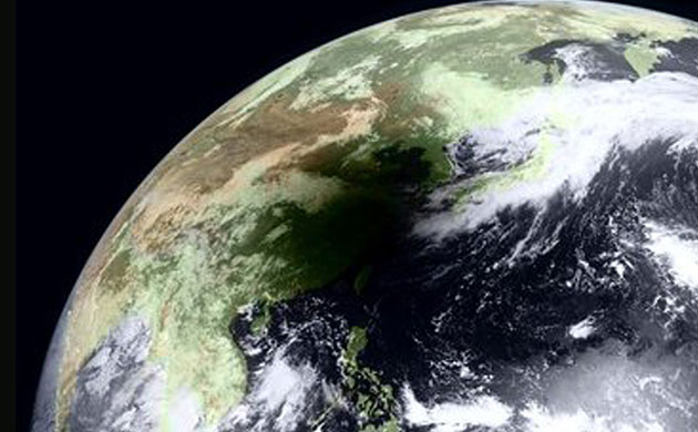
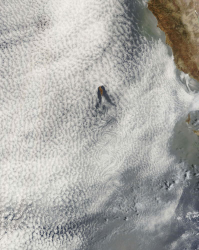
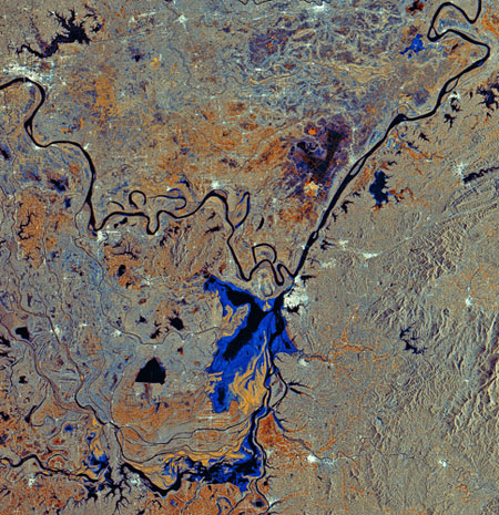
This Japanese satellite image shows the view of Earth at at 9.30am in south-eastern China when the disk of the Moon completely overlapped the disk of the Sun, plunging the region into darkness. Known as a total eclipse, the Moon's shadow engulfed Taiwan and a large swath of the Pacific OceanPhotograph: MTSAT/NASAClouds cover the Pacific Ocean in this image, captured on July 5. The small island visible is Guadalupe Island, which is located off the coast of Mexico's Baja peninsula. The clouds south of the island are shaped like vortices. Turbulence, caused by the wind passing over the island, is what is creating these pronounced eddies in the clouds. This pattern is called a vortex 'street'Photograph: Terra/MODIS/NASAThis image features the Dongting Lake and the Yangtze river in south-central China. Dongting Lake (bottom centre) is China's second largest freshwater body. The lake is fed from the north by the Yangtze (seen snaking across the top of the image) and from the south by the Zi (visible), Xiang, Yuan and Li rivers. This image was created by combining three radar images taken over the same area, with colours representing changes that occurred in the surface between acquisitions. The various colours of blue show the variations in the lake's total areaPhotograph: Envisat/ESA
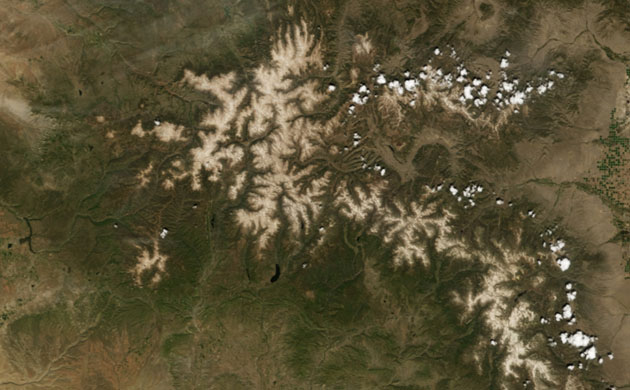
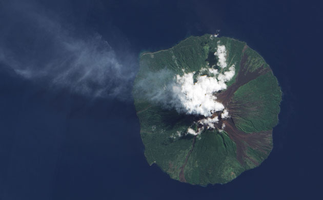
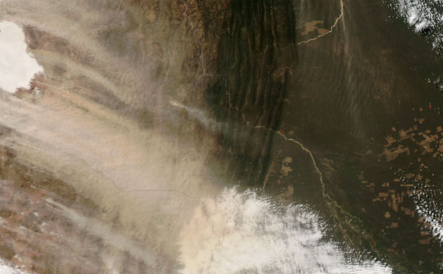
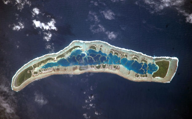
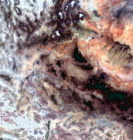
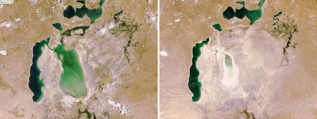
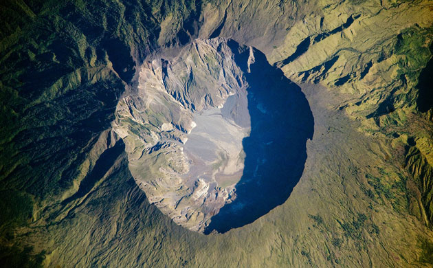
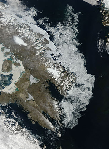
Each winter and spring, airborne dust from the Colorado plateau and the Great Basin regions settles on the snow cover in the San Juan Mountains of south-western Colorado. The dust increases the absorption of solar radiation, which dramatically accelerates snow melt. Winter and spring of 2008 in the Colorado river basin were particularly dusty, with a record-breaking nine airborne dust events. But that record was broken in the winter and spring of 2009 with a landmark 12 events, contributing to a noticeably earlier snow meltPhotograph: NASAManam volcano, just off the coast of mainland Papua New Guinea, released a faint plume on earlier this month. Bright white clouds hover over the volcano's summit. Clouds often collect over peaks, but these clouds could result from water vapour released by the volcano. Manam is one of Papua New Guinea's most active volcanoes, and it has occasionally caused casualties, including 13 deaths from a pyroclastic flow in December 1996, and four deaths from a mudflow in March 2007. Large eruptions in late 2004 forced the evacuation of the entire islandPhotograph: EO-1/NASADust blew across southern Bolivia on 21 July. Many of the dust plumes were thick enough to completely obscure the satellite's view of the ground surface below. Most of the plumes arose from two salt flats which top Bolivia's Altiplano, or elevated plain. Dust plumes from the salt flats blow toward the south-east, but farther east, smaller plumes arise from the riverbeds of Rio Grande and Rio Parapeti, and head almost straight southPhotograph: Aqua/MODIS/NASAUninhabited Millennium Island - known as Caroline Island prior to 2000 - is part of the Republic of Kiribati, which is comprised of 32 atolls and one raised coral island. The island is formed from a number of smaller islets built on coral reefs that grew around a now-submerged volcanic peak. At a maximum height of approximately 6m (19.7ft) above sea level, Millennium Island has been identified as being at great risk from sea level rise Photograph: ISS/NASAThis satellite images shows the Grand Canyon, one of the seven natural wonders of the world. The canyon (the rock-like formation stretching across the centre of the image in hues of pink, violet and grey), is located in the US state of Arizona. Also visible in the image are the Colorado plateau (upper right corner), the Mogollon plateau (dark area underneath), Lake Meade (Y-shaped water body left of the canyon), Las Vegas, Nevada (bright white and blue area left of Lake Meade) and the southern tip of Utah (upper left)Photograph: MERIS/ESAThis before and after composition shows the dramatic retreat of the Aral Sea shoreline from 2006 to 2009, which appears to have shrunk at the eastern end by 80% in just three years. Once the world's fourth-largest inland body of water but now a byword for ecological calamity, the Aral Sea has been retreating over the last 50 years after rivers that fed it were diverted for Soviet cotton irrigation projectsPhotograph: Envisat/ESAThe southern part of Tikehau atoll, one of the 78 coral atolls that make up the Tuamotu archipelago in French Polynesia. Patches of coral make star-like spots across the turquoise expanse of the lagoon. A line of tree-covered islets encircles the lagoon. At the southernmost tip of the atoll, a large islet accommodates a small village and an airstripPhotograph: EO-1/NASAAt the northern end of the Chihuahua desert, which stretches from the south-western United States into northern Mexico, sits a field of gleaming white sands that form otherworldly dunes. The sands are formed from gypsum, a soft mineral often left behind when water bodies evaporate. Although gypsum is a fairly common mineral, it is rarely found as sand because it easily dissolves in water and is carried out to sea. In the case of the White Sands national monument, however, waters flowing into the basin found no outlet and evaporated. Over many years, the gypsum crystals were subjected to freezing, thawing, and wind, and broke down into tiny grainsPhotograph: NASAOn 10 April, 1815, the Tambora volcano in Indonesia produced the largest eruption in recorded history. An estimated 150 cubic kilometres of tephra (exploded rock and ash) resulted, with ash from the eruption seen at least 1,300km away to the north-west. Enough ash was released into the atmosphere from the eruption to reduce sunlight, resulting in global cooling and an 1816 that saw no summer. The huge caldera, 6km in diameter and 1,100m deep, formed when Tambora's estimated 4000m-high peak was blew off and the magma chamber below emptied Photograph: ISS/NASAIn the depths of winter, ice hugs the coastline of Canada's Baffin Island. Summer sunlight, however, dramatically melts the ice away from the coastline. Seasonal sea ice retreat was well underway on 11 July. Since the turn of the 21st century, however, Arctic sea ice extent has declined sharply, experiencing a series of low summertime extents and poor wintertime recoveries. Arctic sea ice extent set a record low in September 2007. In the first half of July 2009, sea ice declined faster than it did in 2008, but not as fast as it did in 2007, according to figures from the National Snow and Ice Data CenterPhotograph: Terra/MODIS/NASA
Sign up to read this article
Read news from 100’s of titles, curated specifically for you.