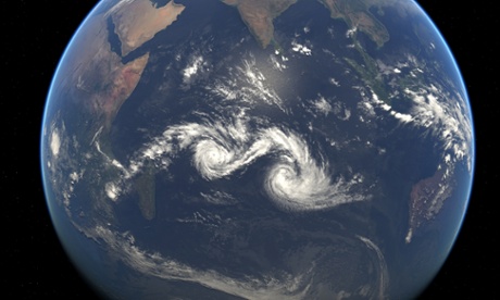
Two tropical cyclones— Diamondra and Eunice—swirled over the central Indian Ocean, in January. Neither storm was particularly strong, nor were they expected to make landfall or cause significant damage. But their close proximity offered striking views to satellites.
If two tropical cyclones draw near each other, they begin to rotate cyclonically around an axis connecting their centres – something meteorologists call the Fujiwhara effect. Such binary storms can even merge if their centres get close enough, although that was not the case here.
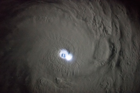
Though this image may look like it comes from a science fiction movie, it is in fact a photograph of tropical cyclone Bansi over the Indian Ocean, seen at night by astronauts on the International Space Station (ISS). The eye of the cyclone is brilliantly lit by lightning in or near the eye wall. The images were taken when the ISS was east of Madagascar.
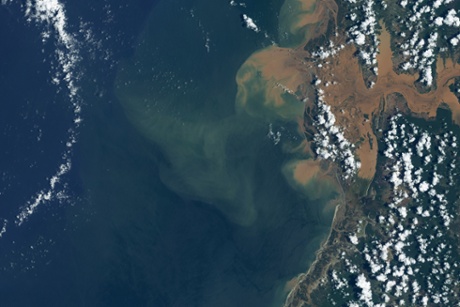
A tropical disturbance that had already swamped southern Africa with rain strengthened into tropical storm Chedza as it passed over the Mozambique Channel on 15 January. When Chedza passed over Madagascar the next day, it brought lashing winds and heavy rains that killed at least 13 people, destroyed or damaged more than 3,000 homes, and displaced 9,500 people. This image is of flooding along Madagascar’s Tsiribihina river.
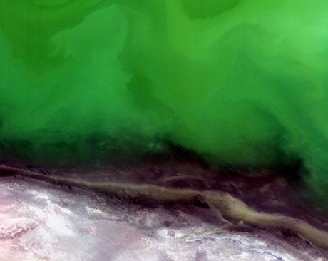
The shoreline of the northeastern Caspian Sea, the largest landlocked water body in the world. The water appears green in this image, indicating an algal bloom. These blooms deplete the amount of oxygen in the water, threatening aquatic life. The Caspian Sea is an important site for sturgeon, which yield roe (eggs) that are processed into caviar. The mineral-rich land of Kazakhstan’s Mangistau region is visible along the bottom of the image.
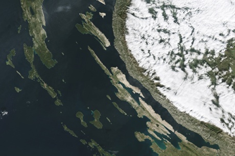
The Dinarnic Alps follow Croatia’s long Adriatic coast like a curving spine. Reaching heights up to 6,007 ft (1,831 meters), the mountains provide a dramatic backdrop to Croatia’s popular coastal resorts. They also divide two of the country’s climatic zones. West of the mountains, the mild winters and dry summers of a Mediterranean climate reign on the coast. On the eastern side are the country’s coldest and wettest places in the Croatian Highlands. This image shows the role that the Alps play in managing moisture – dense clouds on the right are trapped by the Velebit Mountains and cover the Lika region.
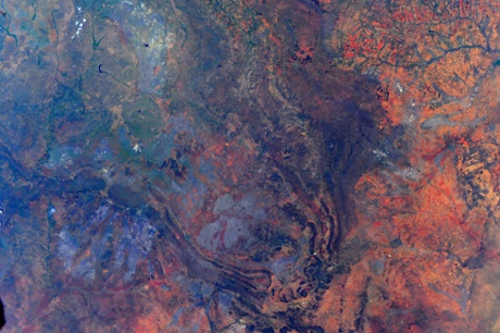
Colours going wild in South Africa, taken by Italian ESA astronaut on ISS Samantha Cristoforetti, the first Italian woman astronaut in space.
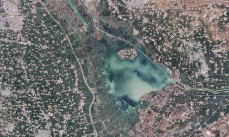
Nansi Lake in China’s Shandong province. With more than 96 million people living in Shandong, the fingerprints of human civilization are all over this shallow lake. As seen in this natural-colour image, much of the lake is being used for either aquaculture or farming. The outer edges of the lake have been converted into land, while rectangular ponds are located closer to the centre of the lake. People access the ponds by plying small boats through a network of canals.
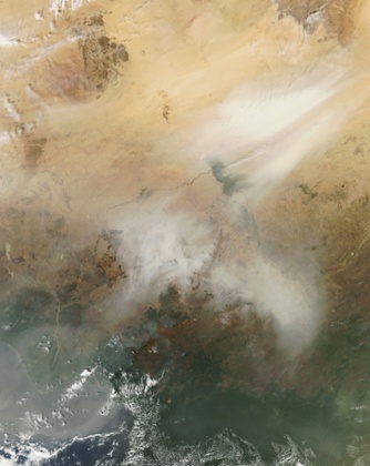
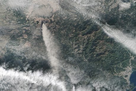
Dozens of fires burning in Central Africa on 4 January. Swirling dust mixes with the smoke from the fires. The location, widespread nature, and number of fires suggest that they were deliberately set to manage land.
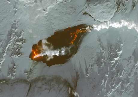
Lava gushes from fissures just north of Vatnajökull, Iceland’s largest glacier. As of 6 January, the Holuhraun lava field had spread across more than 84 sq kms (32 sq miles), making it larger than the island of Manhattan. This false-colour image shows a plume of steam and sulfur dioxide as white, newly formed basaltic rock is black and fresh lava is bright orange.
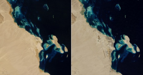
As recently as the 1980s, only 12,000 people lived in Hurghada, Egypt. By 2014, more than 250,000 people lived there and more than one million tourists visit each year, drawn by some of the world’s best diving and snorkelling. But the local environment, particularly the coral reef ecosystem, has paid a price. According to one study, corals near Hurghada have declined by as much as 50% over three decades due to the dredging and dumping of sediment, damage from careless snorkelers and divers, and other factors related to the area’s development.
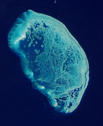
About 100km (60 miles) north of Progresso, Mexico, five small islands stand amid the largest coral structure in the southern Gulf of Mexico. The “Scorpion Reef” or Arrecife Alacranes developed as various species of coral grew together over thousands of years. The area is a national park and Unesco biosphere reserve.
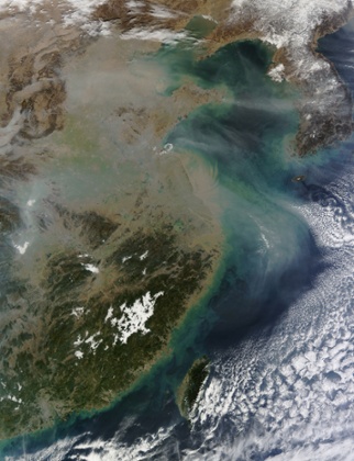
A pollution haze hangs over eastern China, stretching over the China Plain, the Sichuan Basin (southwest), the Bohai Sea and the East China Sea. In some places, especially the northern China Plain, the haze is so thick that it obscures the ground almost completely.
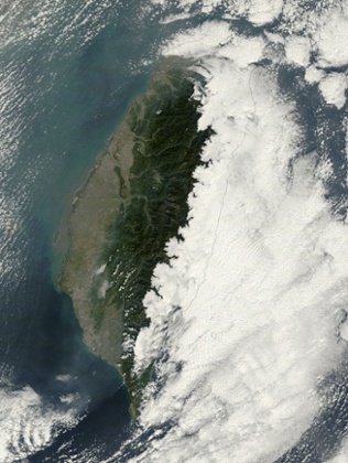
Fog is widespread and common in Taiwan, especially east of the country’s Central Mountains, as seen in this image taken on a winter’s day. The western two thirds of the country are easily viewed from space but from the summit of the Central Mountains to the east over the Pacific Ocean land and sea are completely obscured by a large bank of low cloud.
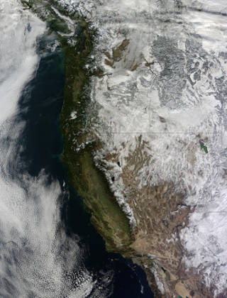
Much of the Western US was under a blanket of snow at the beginning 2015, with snow even dusting Arizona’s Grand Canyon.
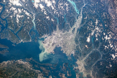
In British Columbia, the Fraser River winds for almost 1,400 km (870 miles), alongside the Rocky Mountains, through the Coast Mountains and the Fraser Canyon into the Strait of Georgia. Along its journey, the river picks up a huge load of silt — about 20 million tonnes each year. Most of it flows into the Strait of Georgia, while about 3.5 million tonnes is left behind and deposited in the lower river valley. The silt gives the river a milky colour; this effect is most pronounced at the river’s mouth, where the freshwater plume is visible even from space.
Those silty sediments carry nutrients that support phytoplankton growth, which in turn become the center of a food web for grazers like the sockeye salmon that hatch in the Fraser. Those nutrients are recycled back to the Fraser when the salmon return four years later to spawn.
The photograph above was taken on 6 September 2014, by an astronaut on the International Space Station. According to news reports, September 2014 saw the return of as many as 23 million salmon to the Fraser River.
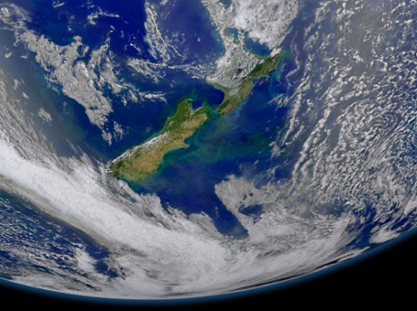
Phytoplankton blooming in New Zealand to the east of the islands and along the Chatham Rise area of ocean floor.
Ash drifts south from Mount Aso on Japan’s Kyushu island.
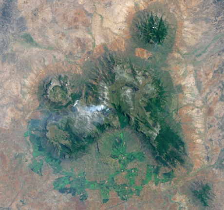
In southern Malawi, near the border with Mozambique, the land rises sharply into a multi-lobed plateau that towers about 4,600ft (1,400 meters) above the landscape. The feature, an inselberg known as Mulanje massif, is the highest point in south-central Africa. Today, about 20 rocky peaks are found on the plateau. Since the image was taken during the dry season, browns and reds dominate the lower-elevation areas surrounding the plateau. The bright green areas south and west of Mulanje are tea and macadamia farms.
A wildfire is also visible on the plateau in the Landsat image. “Fires are frequent and a bad sign, often set by illegal loggers,” explains Joy Hecht, an environmental consultant who has conducted field research on Mulanje. “The mountain top is a protected forest, and there would not be prescribed burns there.”
Hundreds of agricultural fires are seen burning in Indochina. Places where the thermal sensor detected active fires are outlined in red. The heaviest activity can be seen in Cambodia, with heavy clusters or red hotspots wrapping in an arc north and northwest of Tônlé Sab Lake. Intense activity also occurs in eastern Cambodia. A relatively few fires speckle the landscape of Thailand, which lies north and northwest of Cambodia. To the south and east, red hotspots also appear in Vietnam. Areas of dry winter grasses appear light tan, and the region’s remaining tropical forests appear dark green.