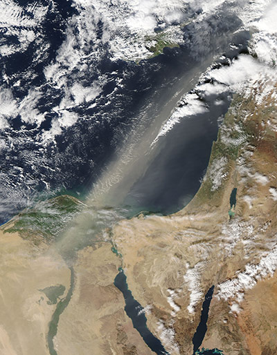
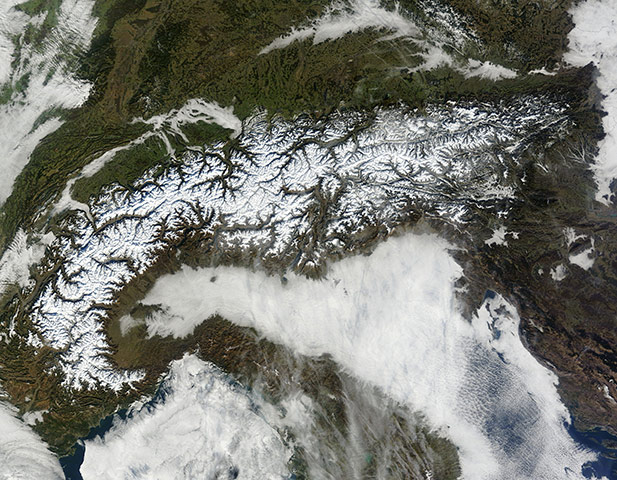
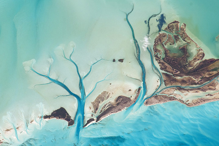
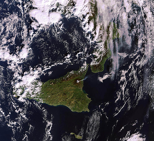
A dust storm blew out of Egypt and over the Mediterranean Sea on 29 January 2011. Spanning hundreds of kilometres, the dust plume extends from Egypt across the Mediterranean Sea, dissipating off the coast of Lebanon. On its journey from Egypt's interior, the dust passes over Cairo and the Nile DeltaPhotograph: Aqua/MODIS/NASAThe Alps form a crescent stretching from the Mediterranean coasts of Italy and France to Vienna, Austria. This natural-colour image shows snow-capped mountains interspersed with vegetated valleys. Clouds snake through valleys in the north and west, and a nearly continuous cloud bank fills the Po Valley in the south, but skies over the mountains are clearPhotograph: Terra/MODIS/NASAThe islands of the Bahamas are situated on large depositional platforms – the Great and Little Bahama Banks – composed mainly of carbonate sediments ringed by reefs. The islands are the only parts of the platform currently exposed above sea level. The sediments were formed mostly from the skeletal remains of organisms settling to the sea floor; over geologic time, these sediments consolidated to form carbonate sedimentary rocks such as limestonePhotograph: Nasa
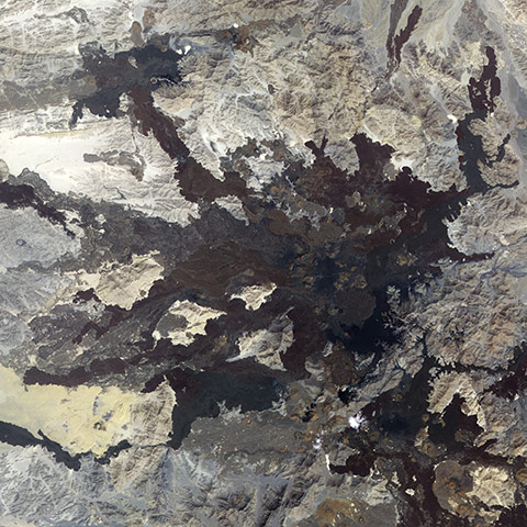
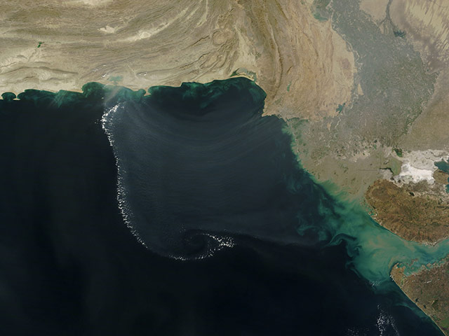
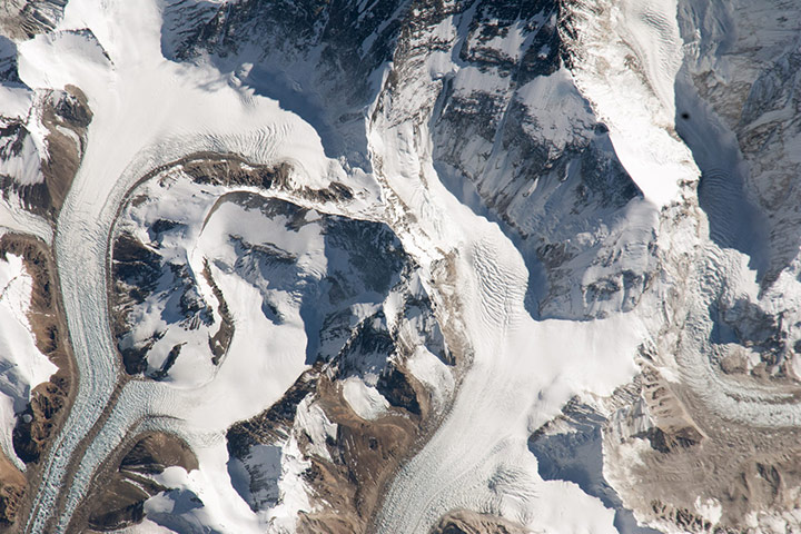
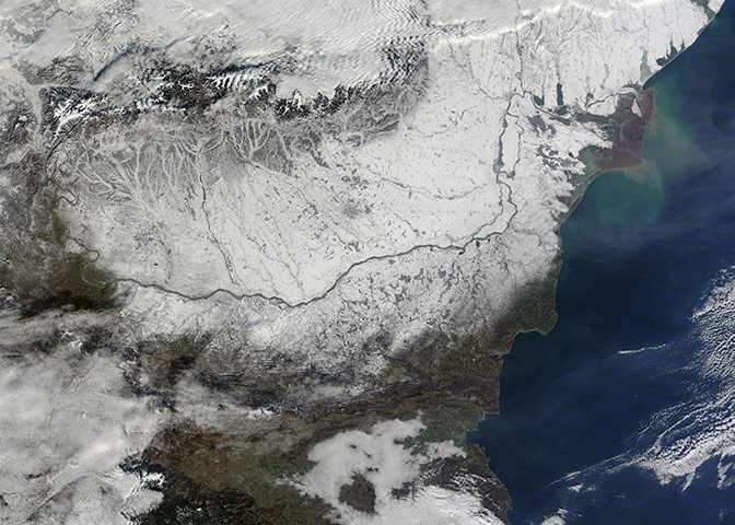
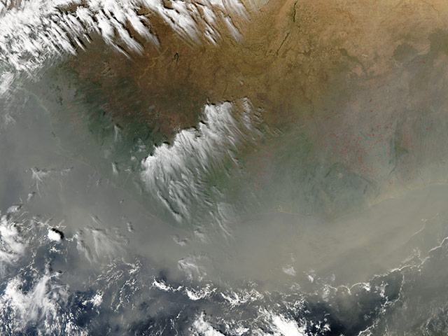
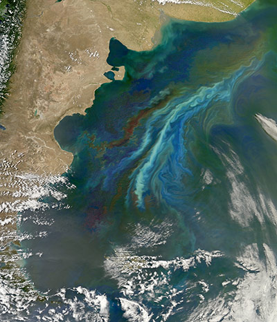
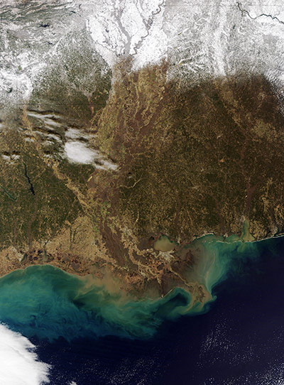
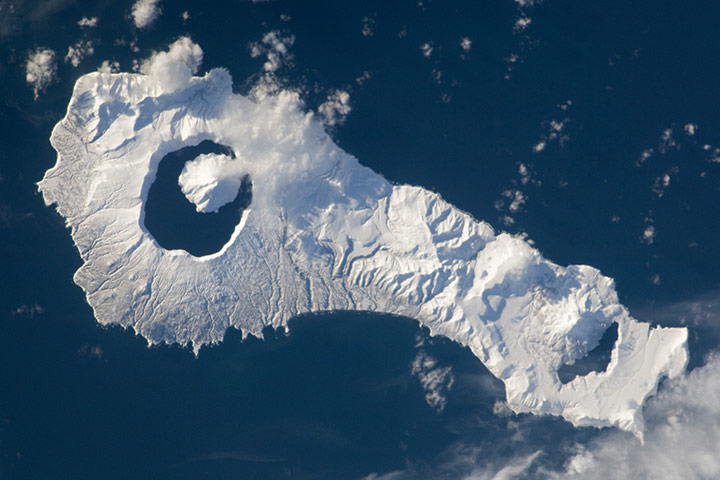
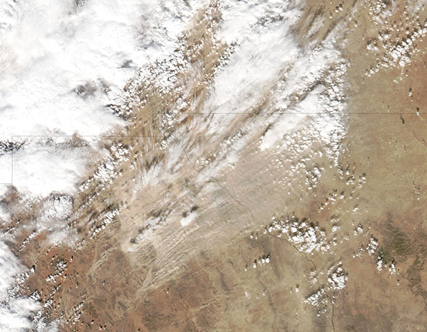
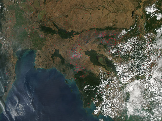
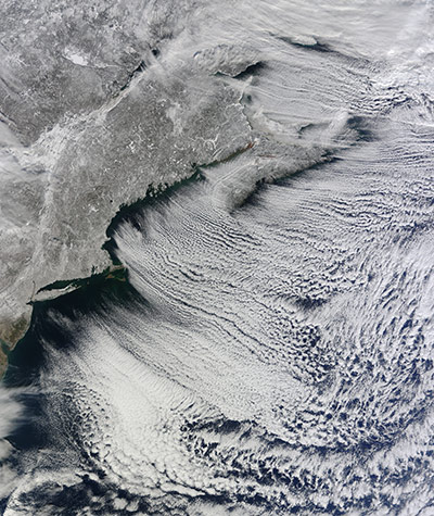
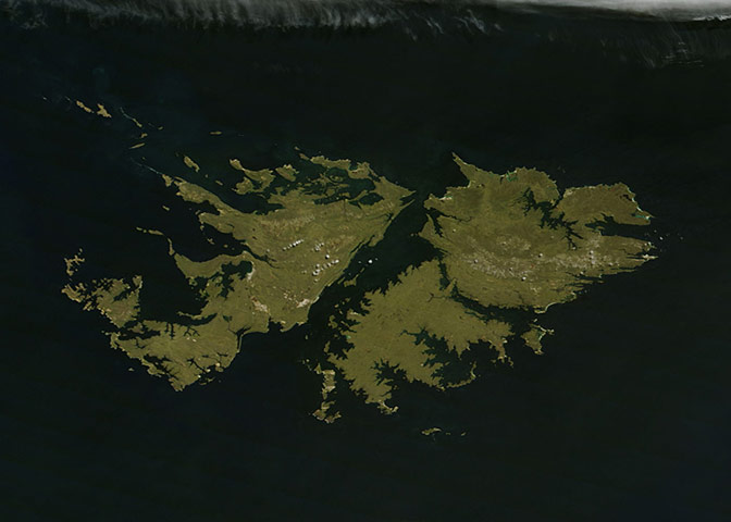
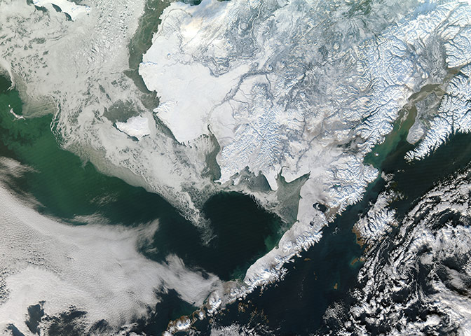
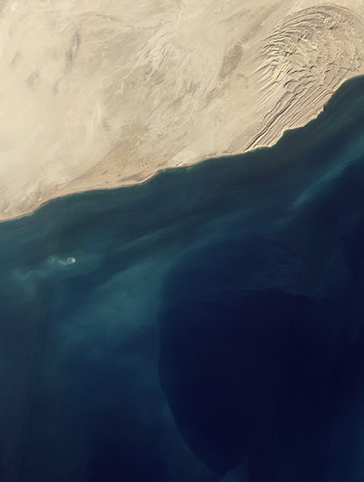
In north-western Saudi Arabia, east of the Red Sea port city of Umm Lajj, lies a field of volcanic lava. Known as Harratt Lunayyir, the lava field contains some 50 cones from volcanic activity in the past 10,000 years (the Holocene Epoch). If scientists long believed the region to be geologically quiet, a seismic swarm in 2009 suggested otherwise. Old lava flows appear as irregular, dark stains on an otherwise light-coloured landscape. Like ink on an uneven surface, the lava has formed rivulets of rock that flow out in all directions Between April and June 2009, more than 30,000 earthquakes struck this region. Although most of the quakes had very low magnitudes, 19 reached magnitude 4 or greater and a 5.4-magnitude quake damaged buildings in a nearby town. Concerned about the potential for a larger quake or volcanic eruption, Saudi officials evacuated roughly 40,000 residents. By August 2009, the seismic activity subsided and residents were allowed to returnPhotograph: ASTER/Terra/NasaRemote sensing instruments orbiting above the earth can capture phenomena that would otherwise be invisible such as this semi-circle of atmospheric gravity waves over the Arabian Sea. The visible wave patterns do not come from waves of water; they are created when the waves in the atmosphere touch the surface of the ocean. Gravity waves form in the atmosphere when there is a disturbance in the air layer, such as when lighter, warmer air moves upward (buoyancy) and then gravity pulls it back down. This creates an oscillation, or wave pattern, that ripples outwards. In the trough of the wave (the low point), the air touches the surface of the ocean, causing the water to be roughened. In the south-east section of the image, swirls of turquoise mark the outflow of sediment from the Gulf of Kutch. To the north, a haze covers the Indus River Valley, and appears to extend over the Arabian GulfPhotograph: MODIS/Terra/NASAThis astronaut photograph highlights the northern approach to Mount Everest from Tibet. Known as the north-east ridge route, climbers travel along the East Rongbuk Glacier (image lower left) to camp at the base of Changtse mountain. From this point at approximately 6,100 metres (20,000 feet) above sea level (asl), climbers ascend the North Col – a sharp-edged pass carved by glaciers, at image centre – to reach a series of progressively higher camps along the North Face of Everest. Climbers make their final push to the summit (just off the top edge of the image) from Camp VI at 8,230 metres altitude. Located within the Himalaya mountain chain, Everest (or Sagarmatha in Nepali) is the Earth’s highest mountain, with its summit at 8,848 metres above sea levelPhotograph: ISS/NASAThe first snowfall of the new year fell with a fury across Central Europe, leaving the lower Danube River valley hidden under a thick white blanket of snow. The snow began to fall on 1 January and by 2 January, two days of high wind and snow had cut power to hundreds of towns and villages in Romania and Bulgaria, blocked roads and forced Bucharest's two airports and some Black Sea ports to close. On the eastern coastline, the faintly purple fan-shape plain marks the Danube delta, where vast flocks of migratory birds gather in the wintertime to find food, shelter and a favourable climate. It is here the Danube drains into the Black Sea. In the centre of the image, Bucharest, the capital of Romania and home to approximately 2 million people, can be seen as a large grey circle against the snowy white background of the Romania PlainPhotograph: MODIS/Terra/NASADust from a powerful Saharan storm mixed with smoke from hundreds of fires to form a dense blanket in the skies above western Africa. The blanket is so thick that it completely obscures the land and ocean, leaving the vaguest impression of the coastline visible. Black borderlines have been overlain on the image, helping to discern the divisions between the countries. The ocean begins where the black line stops abruptly. From the west to east, the countries that lie on the coast are Guinea-Bissau, Guinea, Sierra Leone, Liberia, Cote d'Ivoire, Ghana, Togo and Benin. The inland countries, from west to east, are The Gambia, Senegal, Mali, Burkina Faso and Niger. The presence of dust in the atmosphere has impressive and wide-spread implications for global climate and environment, affecting human health, soils, the ocean, the atmosphere and the climatePhotograph: MODIS/Aqua/NASAThis astronaut photograph illustrates flooding in the suburbs of Brisbane, Australia, which experienced catastrophic flooding following unusually heavy rain on 10 January 2011. With soils already saturated from previous rainfall, eastward-draining surface flow caused the Brisbane river to flood – inundating an estimated 20,000 homes in suburbs of the capital city of Queensland. The light-coloured rooftops of residences and other structures contrast sharply with green vegetation and brown, sediment-laden floodwaters. Most visible low-lying areas are inundated, perhaps the most striking being Rocklea at image upper left. The suburb of Yeronga (lower left) also has regions of flooding, as does a park and golf course located along a bend in the Brisbane River to the south of St Lucia (image centre). Flooding becomes less apparent near the higher elevations of Mt Coot-Tha (image right)Photograph: ISS/NasaOff the coast of Argentina, two strong ocean currents recently stirred up a colourful brew of floating nutrients and microscopic plant life just in time for the summer solstice, a massive phytoplankton bloom off of the Atlantic coast of Patagonia on 21 December 2010Photograph: MODIS/Aqua/NasaAn unusual view of snow across the southern United States on 12 January 2011Photograph: MODIS/Terra/NASASnow cover highlights the calderas and volcanic cones that form the northern and southern ends of Onekotan Island, part of the Russian Federation in the western Pacific. Calderas are depressions formed when a volcano empties its magma chamber in an explosive eruption and then the overlaying material collapses into the evacuated space. The northern end of the island (image right) is dominated by the Nemo Peak volcano, which began forming within an older caldera approximately 9,500 years ago. The last recorded eruption at Nemo Peak occurred in the early 18th century. The southern end of the island was formed by the 4.6 mile-wide Tao-Rusyr Caldera. The caldera is filled by Kal’tsevoe Lake and Krenitzyn Peak, a volcano that has only erupted once in recorded history (in 1952). Extending between north-eastern Japan and the Kamchatka Peninsula of Russia, the Kurils are an island arc located along the Pacific 'Ring of Fire' Photograph: ISS/NASAA plume of smoke billowing into the atmosphere from Mount Etna, Sicily, Italy. Activity gradually increased the following day, peaking in the eveningPhotograph: MERIS/Envisat/ESAOn 30 December 2010, a dust storm blew from northern Mexico across the borders of Texas and New Mexico, skirting the cities of El Paso and Juarez. This part of northern Mexico is dotted with dry salt lakes and small sand seas, providing ample material for dust storms. Multiple source points looking like tiny pinpoints of beige fanning out toward the north-east appear in the lower left quadrant of the image. Clouds float overhead, casting shadows onto the dust plumes belowPhotograph: MODIS/Aqua/NASADozens of fires burning in Indochina, especially in western Cambodia on 21 January 2011. The fires are outlined in red. Most of the fires burn in grass or cropland, which is tan in this image. The deep green forest that surrounds the Tonle Sap lake, which appears a murky green in this image, and exists in fringes elsewhere is mostly free of fires..The location, widespread nature, and number of fires suggest that these fires were deliberately set to manage land. Farmers often use fire to return nutrients to the soil and to clear the ground of unwanted plants. While fire helps enhance crops and grasses for pasture, the fires also produce smoke that degrades air quality. In south-east Asia, the agricultural burning season usually runs from mid- to late-January, after the year's primary crops are harvested, through April or May, when the next growing season beginsPhotograph: MODIS/Aqua/NasaBetween two major and debilitating storms, a cold Arctic air mass brought bitter chill, moderate snow, and strong winds to the eastern United States and Canada. On 24 January 2011, the snow clouds finally parted. A frosty white glaze covers the tan land of the north-eastern United States and the provinces of Quebec, New Brunswick, and Nova Scotia, Canada. Off the entire eastern coast, a massive bank of clouds stretches far across the Atlantic in delicately arcing, parallel rows. These formations, known as 'cloud streets', have been sculpted by the prevailing westerly windsPhotograph: MODIS/Terra/NasaThe green Falkland Islands sparkle in the southern Atlantic about 250 nautical miles (460 miles) off the coast of southern Argentina. Also known as Islas Malvinas, the archipelago consists of over 775 islands and is a self-governing British Overseas Territory. The island nation contains approximately 4,700 square miles of land, but has a very long coastline, estimated at 800 miles. Most of the land is found on the two main islands, West Falkland and East Falkland, left to right in this image, respectively. The green land offers rich pasture, and domestic sheep graze much of the land of the two main islands. The population of sheep here has been estimated at over a half-million animalsPhotograph: MODIS/Terra/NasaWinter snow blankets south-west Alaska on, bringing the varied topography of the region into sharp relief. Near the upper edge of the image, just left of centre, the white arc of the Yukon river delta protrudes into the ice-covered Bering sea. The spreading branches of the Yukon river appear blue-white within that arc, creating a design which looks much like a stylized leafless tree on a snowy background. The Yukon river delta provides a rich habitat for many species of animals, particularly waterfowl. Millions of ducks, geese and shorebirds create a cacophonous spectacle each spring as they return to their nesting grounds in this region. The Yukon river and Bering sea are extremely important salmon habitats, providing much of the world's supply of wild-caught salmon. Along the coast, the waters of the Bering sea are home to a variety of marine mammals, including migrating whalesPhotograph: MODIS/Aqua/NASAOn 26 November 2010, Pakistani fishermen returned from a day at sea to report that a new island had emerged. The tiny dot of land was a mud volcano, and it was still visible on 11 January 2011. There’s no need to change any maps, however; mud volcanoes have risen off the coast of Pakistan in the past and disappeared again within a few months, washed away by the waves and currents in the Arabian sea. It is quite likely that this new volcano will meet the same fate. A stream of pale brown sediment was snaking away from the volcano to the west on 11 January suggesting that erosion was already under wayPhotograph: ALI/EO-1/NASA
Sign up to read this article
Read news from 100’s of titles, curated specifically for you.