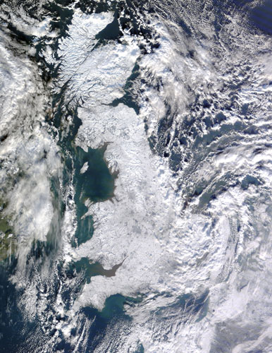
Snow covers most of England, from the east to the west coast. The cities of Manchester, Birmingham, and London form ghostly grey shapes against the white land surface. Immediately east of London, clouds swirl over the island, casting blue-grey shadows toward the north. The heavy snowfall downed power lines, leaving several thousand homes in southern England without electricity
Photograph: MODIS/Terra/NASA

Photograph: MODIS/Terra/NASA
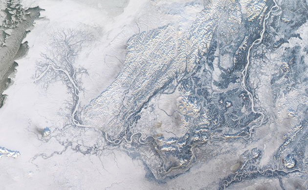
Like a winter-bare tree, a network of roots, or the veins, arteries and capillaries that enclose an organ, the Yukon River branches across the snowy Yukon Delta to the Bering Sea. Each branch flows into the Bering, but the coastline is invisible in this image. The shallower water near shore has frozen, and the white sea ice blends with the white, snow-covered coast
Photograph: MODIS/Aqua/NASA
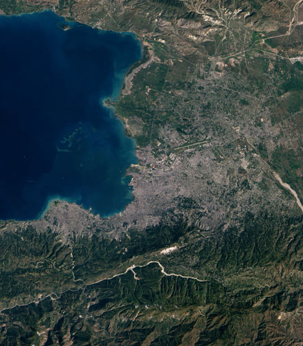
While not detailed enough to reveal earthquake damage to houses and buildings, this regional view of Port-au-Prince illustrates some of the physical obstacles that have complicated the job of aid workers in the aftermath of the recent disaster. The capital city is densely populated and densely built, with little open space apparent amid the grey pavement and buildings. The single port through which large cargo ships can approach the city (image centre) has been damaged, and the city's only landing strip (top right) was overwhelmed by the number of flights trying to land and take off. (The epicentre of the earthquake is at the bottom of the picture.)
Photograph: ALI/EO-1/NASA
Photograph: NASA
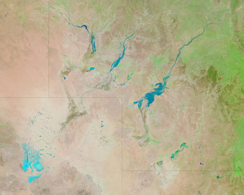
River channels run throughout south-western Queensland, but most of the time, the channels are dry. In this area known as Channel Country, which sprawls across multiple Australian states, rainfall is sparse and erratic. Although rare, floods can change the landscape dramatically. That was the case in January 2010 when floodwaters created impermanent lakes, and the local towns of Davenport Downs and Windorah were surrounded by floodwaters
Photograph: MODIS/Aqua/NASA
Along with Arctic temperatures, heavy snowfall covers parts of the Ukraine, Moldova, Romania, Bulgaria, Greece and Turkey. The cold snap is a result of cold Arctic air sweeping across the region. The northerly wind is visible in the cloud formations over the Black Sea
Photograph: MERIS/Envisat/ESA
At 1:15pm Calcutta time the Moon's shadow fell on India and the Bay of Bengal. The shadow spanned a north-south distance of about 185 miles on the surface, with the darkest part near the mid-point of the span. At the height of the eclipse, which occurred over the Indian Ocean, the complete disk of the moon was visible against the Sun for 11 minutes and eight seconds, making this event the longest annular eclipse anticipated for the next millennium
Photograph: MODIS/Aqua/NASA
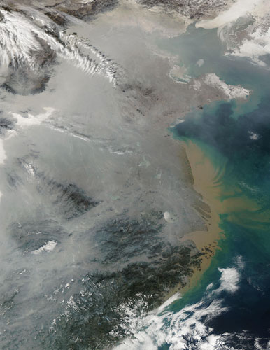
A winter temperature inversion likely contributes to the widespread haze over eastern China. This image shows the densely populated and industrialised north China plain between Beijing and the Yangtze River, where the haze is so dense that it completely obscures the ground. The air near the ground cannot rise and mix with the rest of the atmosphere, meaning that pollutants build up near the surface until the inversion lifts. In China, most of the pollutants are released from burning coal for power and heat
Photograph: MODIS/Aqua/NASA
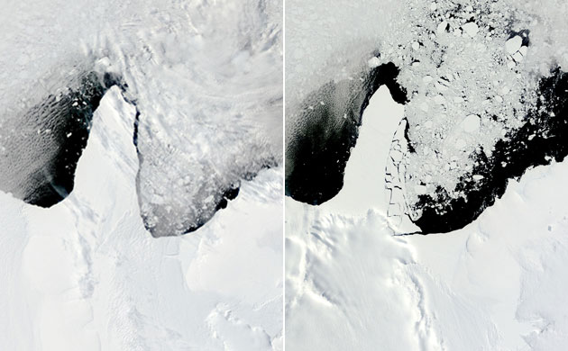
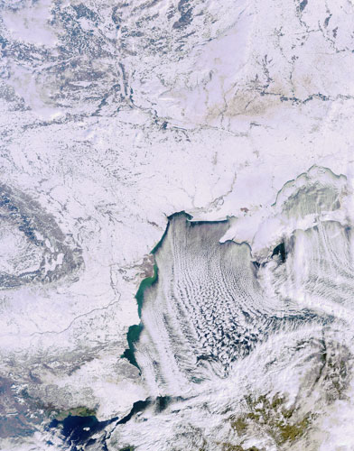
Within a 24-hour space, an area of sea ice larger than the state of Rhode Island broke away from the Ronne-Filchner ice shelf and shattered into many smaller pieces. In the afternoon of the 12th the ice shelf is clearly in one piece (left). By the next morning it is already breaking up (right). Even though the images show a routine event, they provide a spectacular view of the sometimes dramatic arrival of summer in the polar south
Photograph: MODIS/Aqua and Terra/NASA
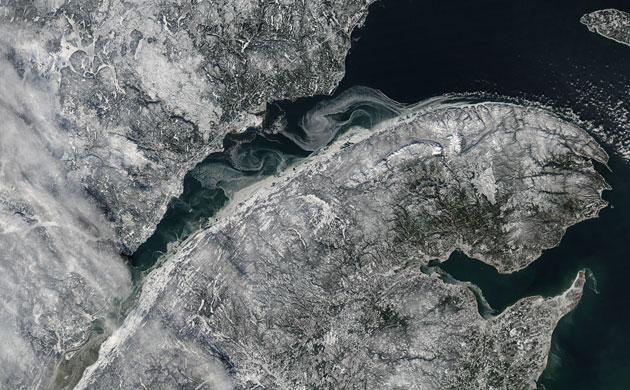
The river carries water from the Great Lakes out into the Gulf of St Lawrence and then into the Atlantic Ocean. In this image, Quebec City is near the bottom left corner. The St. Lawrence River runs diagonally across the image
Photograph: MODIS/Aqua/NASA
Photograph: ISS/NASA
Photograph: ISS/NASA
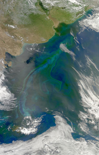
In the South Atlantic Ocean, nestled in the curve of southern South America, things are about perfect for microscopic ocean life. Tiny, plant-like organisms, 'phytoplankton', thrive throughout the southern hemisphere's spring and summer on an abundance of nutrients and long hours of sunlight. This image shows many different species of phytoplankton colouring the ocean's surface
Photograph: MODIS/Aqua/NASA
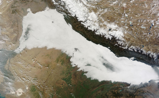
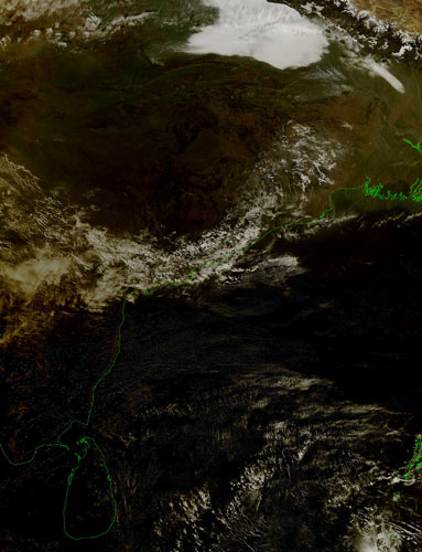
Heavy haze frequently collects in this region due to a few factors. Agricultural fires and increased fuel burning for warmth during the colder weather increase the amount of pollutants. In addition, cool air from the Himalayas sinks over the south side of the mountain range, trapping liquid aerosols or solid particles suspended in air
Photograph: MODIS/Terra/NASA
Photograph: ISS/NASA