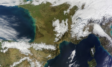
Winter in Europe
Thick snow blanketed mountain ranges in south-western Europe, above, after a storm pushed through the region in early February. The Moderate Resolution Imaging Spectroradiometer (Modis) on Nasa’s Terra satellite captured this image of the snow-covered peaks of the Cantabrian mountains, the Pyrenees, the Alps, and Massif Central on 9 February 2015.
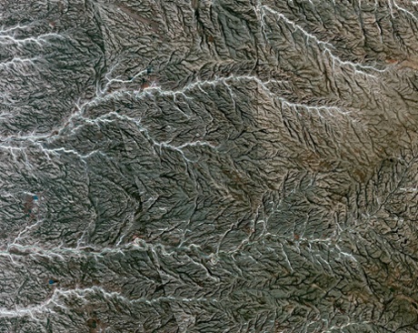
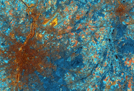
Prince Patrick Island, Canada
Prince Patrick Island, above, in the Canadian Arctic archipelago, is the western-most Elizabeth Island in the Northwest Territories of Canada. The island is underlain by sedimentary rocks, cut by still-active faults. The streams follow a dendritic drainage system: there are many contributing streams, which are joined together as the tributaries of the main river.
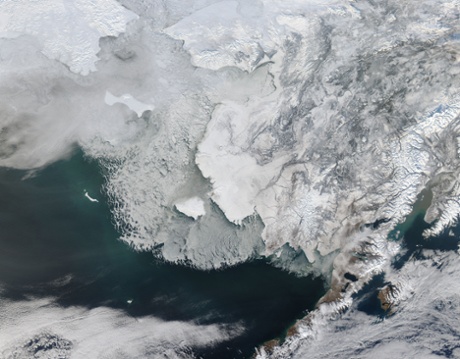
Sea ice off western Alaska
In the image above, snow and ice-covered land appear bright white while the floating sea ice appears a duller grayish-white. Snow over the land is drier and reflects more light back to the instrument, accounting for the very bright colour. The higher water content in ice over an ocean makes it appear duller, as does thinner ice.
The ice-covered areas in this image, as well as the Beaufort Sea, to the north, are critical areas for the survival of the threatened ringed seal, that uses the sea ice to rear their young. In December 2014, the National Oceanic and Atmospheric Administration proposed that much of this region be set aside as critical, protected habitat for the ringed seal.
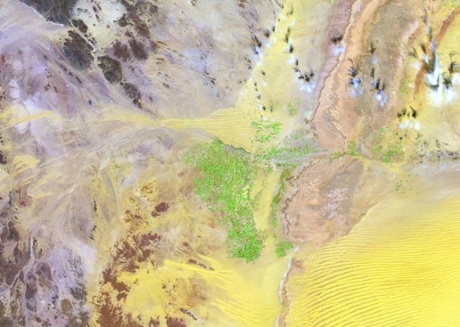
Irrigation in the Arabian desert
The agricultural sector in Saudi Arabia is growing quickly. However, surface water is very scarce on the Arabian peninsula, necessitating innovative solutions to water collection. This image shows how irrigation is applied in the Arabian desert. The bright green spots are centre-pivot irrigation fields, where water is drained from fossil reservoirs to ensure sufficient water for agricultural activities. The water is mined from depths of one kilometre, pumped to the surface and then distributed to the fields for irrigation.
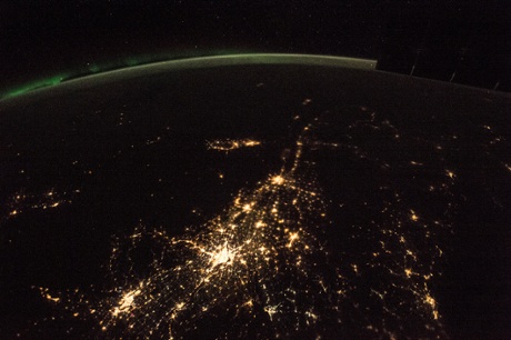
Eastern Canada at night
Astronauts on the International Space Station took this panorama of the St Lawrence river in eastern Canada. The image shows Montreal as a major cluster of lights. The provincial capital, Quebec City (population 770,000), is visibly smaller than the Montreal metropolitan area (population 3.8 million).
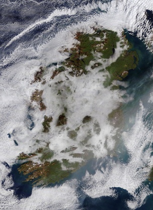
Low cloud over Ireland
A high pressure system sitting over the North Atlantic Ocean just west of Ireland brought calm winds, that, along with a cold winter chill, made conditions ripe for fog to form.
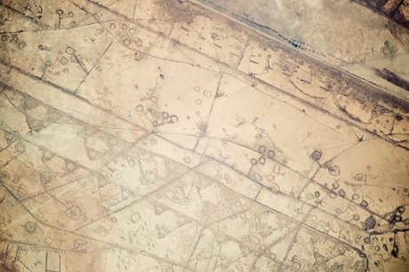
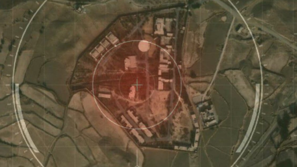
Fortifications on the Iran-Iraq border
Astronauts on the International Space Station took this photograph of land fortifications along a 20-km (12-mile) stretch of the Iraq-Iran border, near the coast of the Persian Gulf. Systems of large curved earthworks, circular gun emplacements and straight connecting roads run parallel to the international border.
First thought to be oil-pad installations, the strategic location of these formations along the international boundary made it easier to see these as patterns of military fortifications. This region of oil refining and exporting was the site of numerous military actions during the war in the 1980s, especially during the defence of the southern city of Basra.
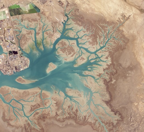
Musa Bay, Iran
Before draining into the Persian Gulf, several rivers and streams in southern Iran converge into Musa Bay, a shallow estuary with a long history as a port. As far back as 326 BC a Greek navigator, Nearchos, noted that the area was already a shipping centre. Today it supports Bandar Imam Khomeini, Iran’s busiest port city. This striking view shows the dendritic branching pattern of the waterways that develops when streams move across relatively flat and uniform rock or over rock that resists erosion.
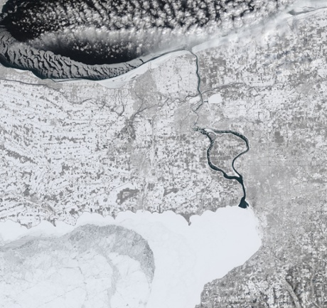
The frozen United States
The eastern half of the United States was trapped in a deep freeze for most of February 2015. Hundreds (maybe thousands) of records have been set for low temperatures and wave after wave of ice and snowstorms have hit the region. This image shows the US-Canadian border along the Niagara river. A manmade ice boom keeps the mouth of the river clear near Buffalo, New York.
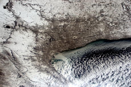
Chicago in winter
European Space Agency astronaut, Samantha Cristoforetti, took this photograph of Chicago and posted it to social media on 19 February 2015 saying: “How do you like #Chicago dressed for winter?”
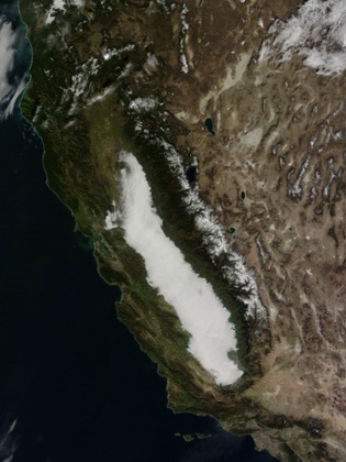
Low clouds in central California
Winter fog is common in California’s Central valley and can be so dense that it snarls traffic, causes fender-benders and can make symptoms worse in those with respiratory disease. At the same time, the moist fog helps keep temperatures low in the rich agricultural region by reflecting sunlight and keeping the ground from warming, which helps keep the abundant fruit and nut trees dormant, allowing for bountiful harvests.
Scientific studies have reported that winter fogs are occurring less frequently in the Central valley. One study, by Dennis Baldocchi and Eric Waller, published in May 2014 found that since 1981 the number of foggy days between November and February has decreased by 46%. The severe drought that California has experienced in recent years may also have decreased the number of fog events even more since 2012.
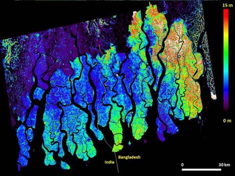
Bangladeshi mangroves
Information on mangrove forest height can be used to estimate biomass, which is extremely important for climate studies and as an energy source in developing countries. This image of mangrove forest in Bangladesh is based on data from the German TanDEM-X satellite and Polarimetric InSAR techniques.
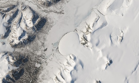
Elephant Foot glacier, Greenland
Pour batter on to a griddle and watch the mixture spread out into a round-shaped pancake. The movement is similar to the flow of piedmont glaciers, which form when ice spills from a steep valley on to a relatively flat plain. These glaciers are known for their nearly symmetric, fan-shaped lobes.
The shape of Greenland’s Elephant Foot glacier, for example, is so distinct that it stands out dramatically from its surroundings when viewed from space.
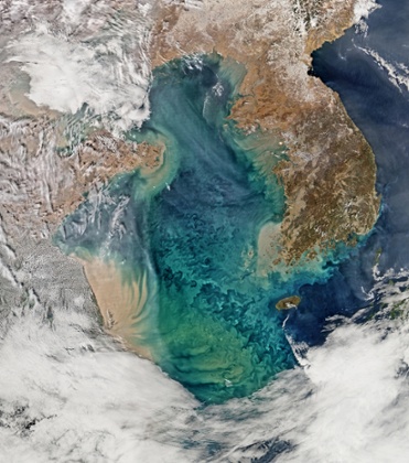
The Yellow Sea
Remote sensing of ocean colour in the Yellow Sea can be a challenge. Phytoplankton, suspended sediments and dissolved organic matter colour the water while various types of aerosols modify those colours before they are seen by orbiting radiometers.
Brussels
This false-colour image shows Brussels, the capital of Belgium.
Darker blue areas throughout the image depict thick vegetation, including the city parks and the large Sonian forest south of Brussels. Stretching over 4,400 hectares, the forest is home to animals including deer, red squirrel and wild boar.
In the upper right is the city of Leuven in the Flemish region, home to the headquarters of Anheuser-Busch InBev – the world’s largest brewing group that includes brands including Beck’s, Budweiser and Stella Artois.
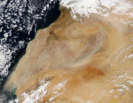
Dust storms in the western Sahara
The Sahara is an arid, broad expanse featuring primarily sand and barren, hard, rocky plateaus. It stretches over most of northern Africa, covering parts of Tunisia, Niger, Morocco, Mauritania, western Sahara, Mali, Egypt, Libya, Chad, Sudan and Algeria. Dust storms are a major natural hazard, especially in spring, and February 2015 was especially active.
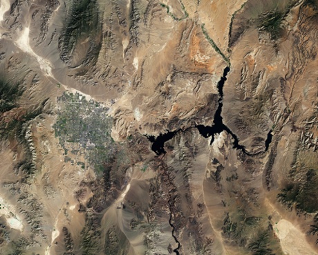
Las Vegas and Lake Mead
This image was taken over Nevada and Arizona in south-west US. Las Vegas with its grid-like urban plan is visible near the centre and the large dark area is Lake Mead. South-east of the city are large, dark shapes in one of the desert valleys. These are solar panels of a large-scale plant called Nevada Solar One. The plant harnesses enough energy to power an estimated 14,000 homes a year.
Satellites can assist in the selection of sites of solar power plants by providing sunshine maps that combine information on overall solar irradiance and average cloudiness. Along with other space-derived products, including digital elevation models, this can help sustainable energy companies pinpoint areas best suited for exploiting solar energy.
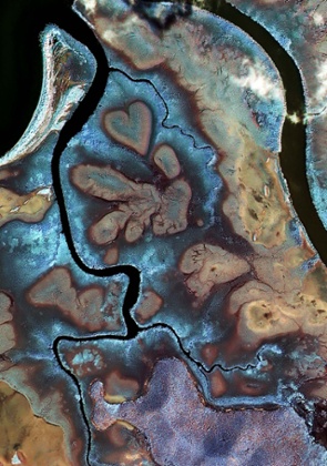
Heart of Voh, New Caledonia
Mangrove swamps along the coast of New Caledonia in the south-west Pacific are pictured above in this false-colour satellite image. The heart-shaped formation – known as the Heart of Voh for its proximity to the Voh commune – is a natural structure caused by changes in vegetation cover.
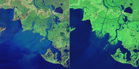
New land on Louisiana coast
While most of the Mississippi delta plain is losing ground, new land is forming in Atchafalaya bay at the mouths of the Wax Lake Outlet and the Atchafalaya river.
Geologists first noticed mud deposits building up in Atchafalaya bay in the 1950s, but new land first rose above the water line in 1973 after a severe flood. Since then, both deltas have grown considerably.
This pair of false-colour satellite images illustrates the growth of the two deltas between 1984 (left) and 2014 (right).