Satellite Eye on Earth: February 2014 - in pictures
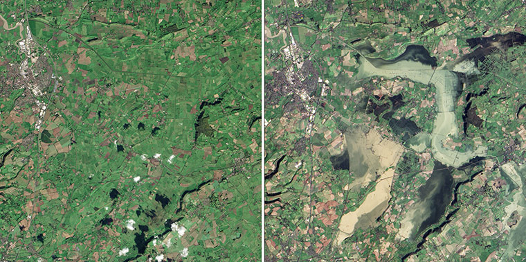
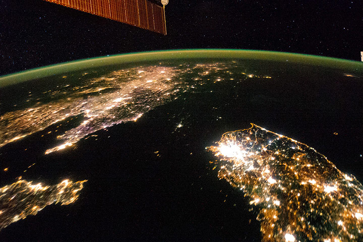
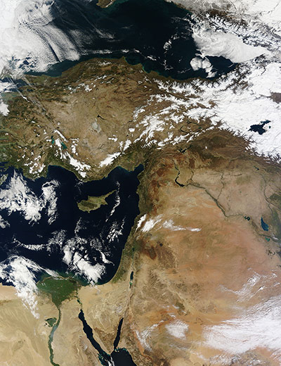
In December 2013 and January 2014, a series of storms dropped 372 millimeters (15 inches) of rain on southern England, making it two-month period the wettest on record since 1910. The storms and rain have continued into February. Since January, both the River Parrett and River Tone burst their banks and flooded sections of the Somerset Levels. By mid-February, an estimated 17,000 hectares (66 square miles) and 150 homes were flooded. The image on the right image, taken on 16 February 16 2014, shows the areas underwater compared to an earlier image, left, taken on 4 November 2013Photograph: Landsat 8 and ALI/EO-1/NASAA night image of the Korean Peninsula. City lights at night illustrate the relative economic importance of cities. In this north-looking view, it is immediately obvious that greater Seoul is a major city and that the port of Gunsan is minor by comparison. North Korea is almost completely dark compared to neighbouring South Korea and China. The darkened land appears as if it were a patch of water joining the Yellow Sea to the Sea of Japan. Its capital city, Pyongyang, appears like a small island, despite a population of 3.26 million (as of 2008)Photograph: ISS/NASAA beautiful nearly cloud-free image of Asia Minor and the Middle East. The blue waters of the Mediterranean Sea are at the centre of the image, with the island of Cyprus south of Turkey. The Black Sea washes the northern coast of Turkey, and north of the Black Sea the bold, rugged ridges of the Caucasus Mountains are coated with a blanket of white snow. At the northern edge of the Caucasus Mountains lies Sochi, the formerly small resort village which has now become the site of the winter Olympics. The broad green triangle in on the south shore of the Mediterranean Sea is the Nile Delta, in northern Egypt, and in the south-east, the largest arid country, partially covered by wispy clouds, is Saudi ArabiaPhotograph: MODIS/Terra/NASA
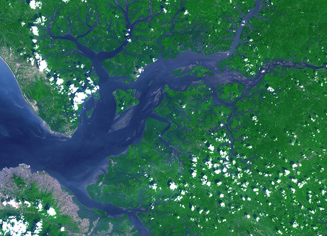
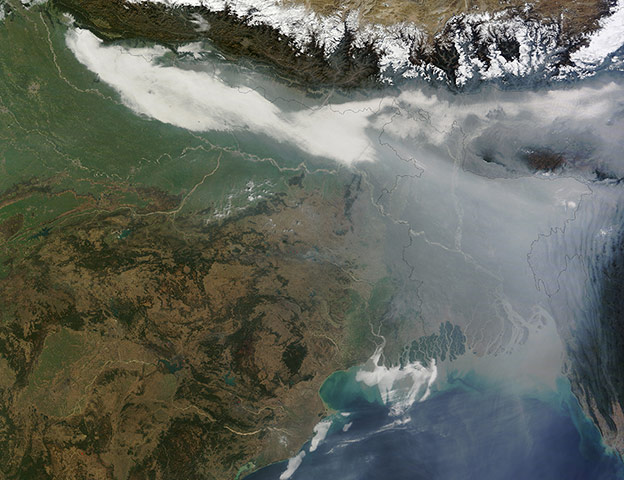
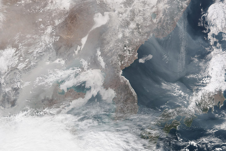
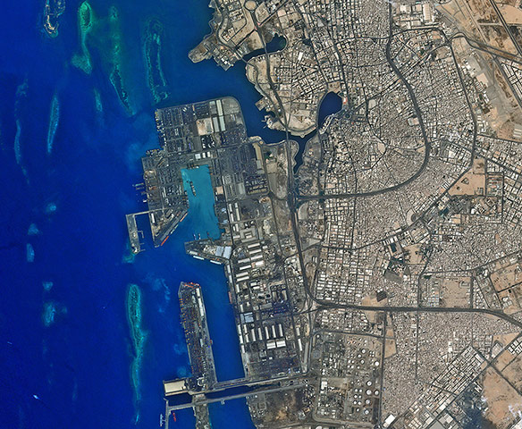
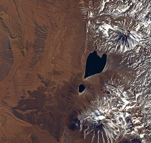
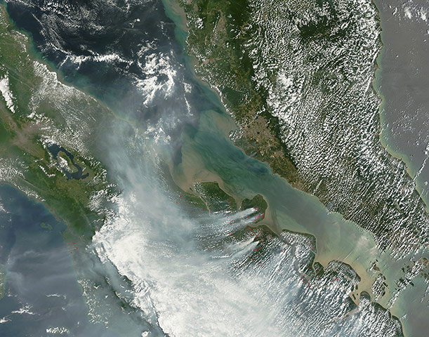
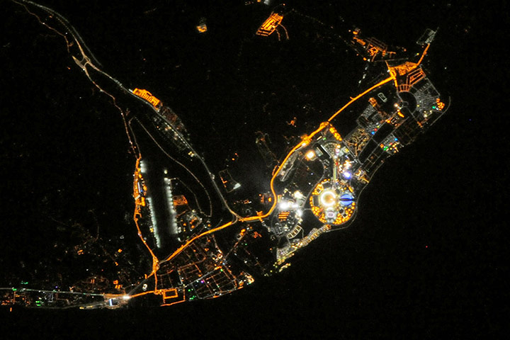
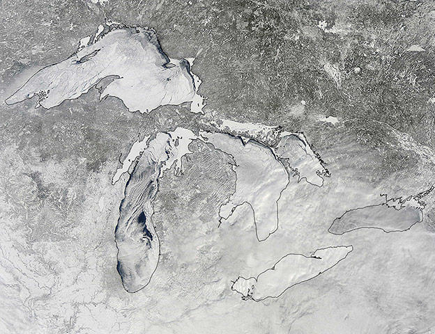
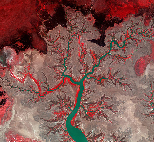
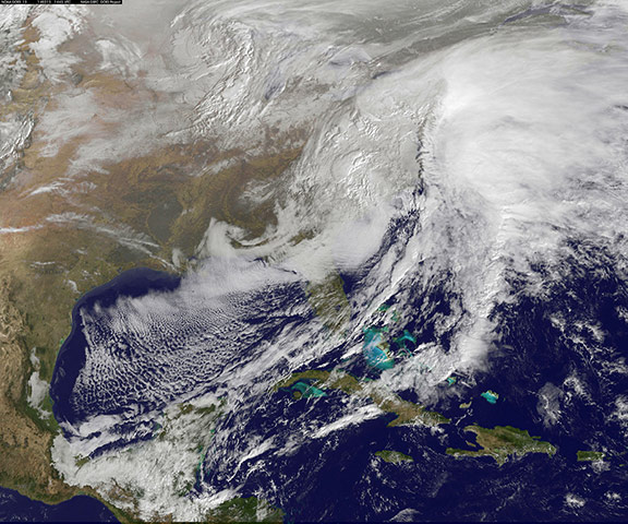
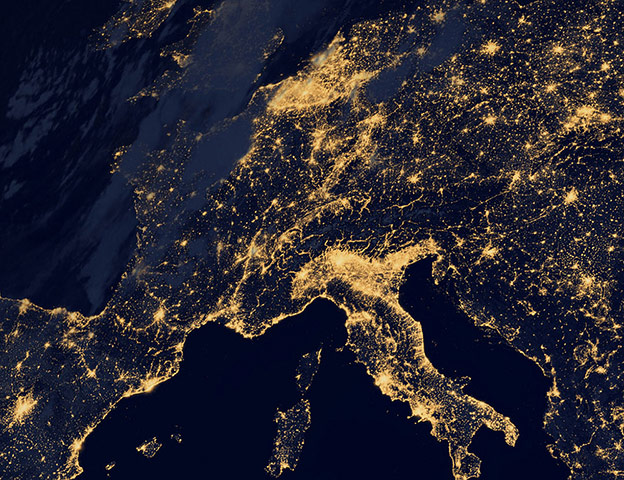
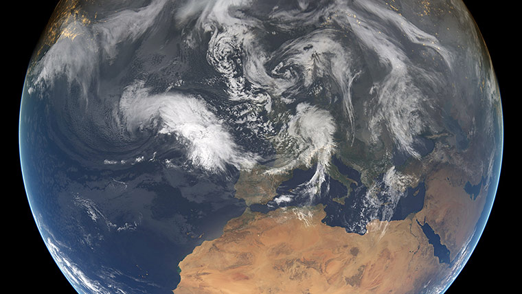
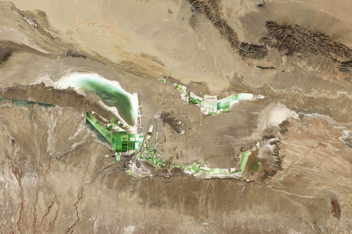
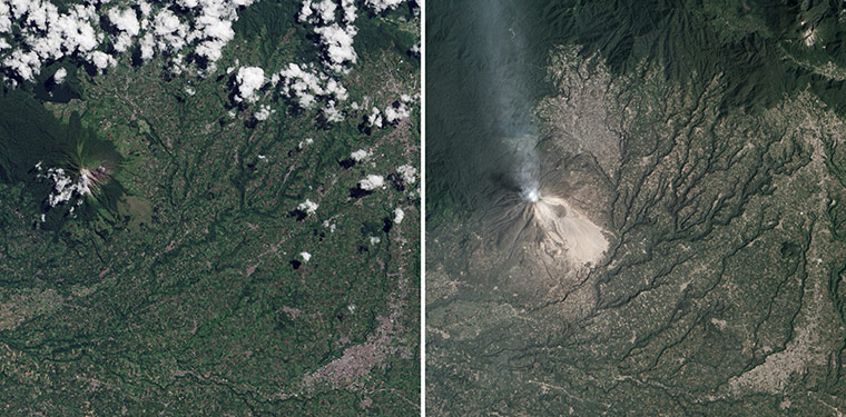
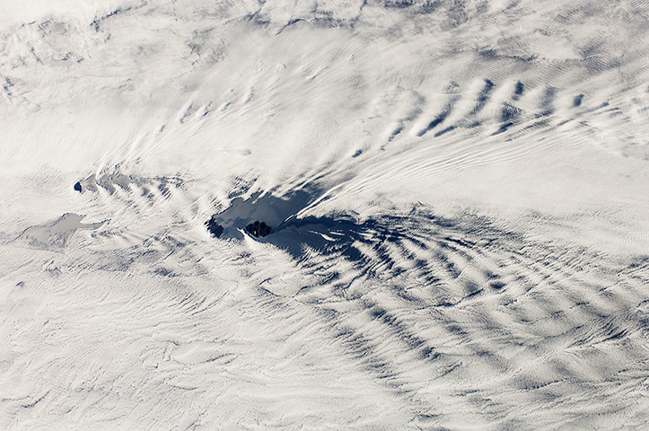
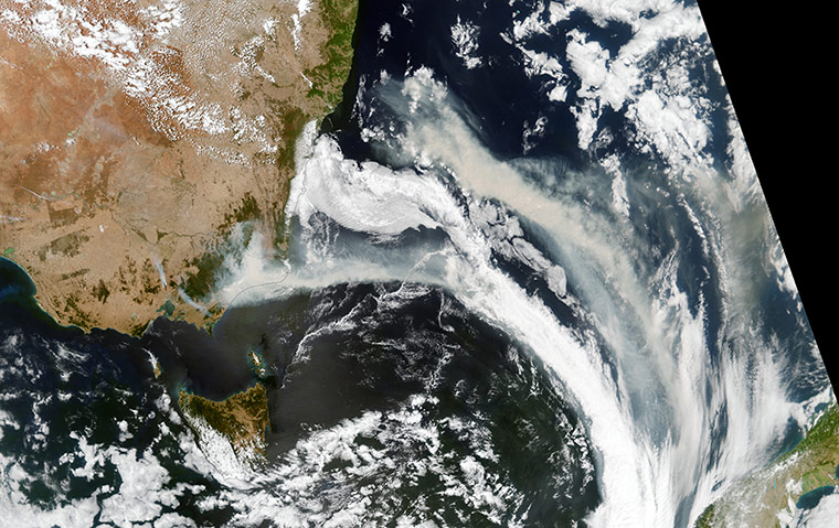
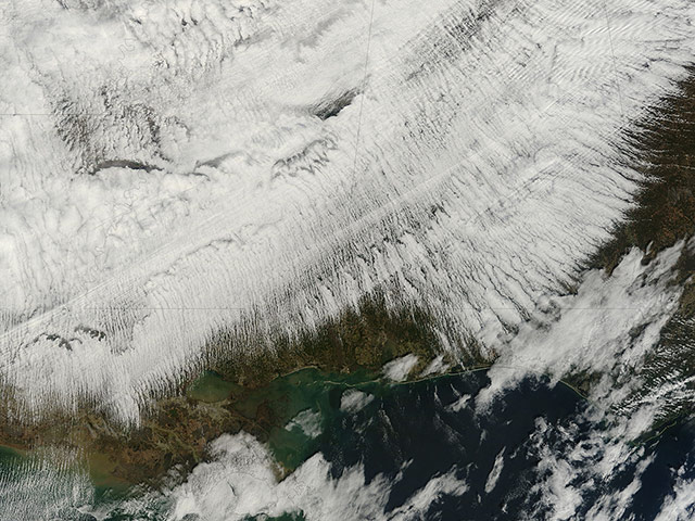
The Sierra Leone estuary became a focal point for trade and interaction between Africans and Europeans in the mid-15th century because of its exceptional harbour. European ships were unable to land along much of the west African coast due to lack of safe anchorage. In contrast, the Sierra Leone estuary offers ideal anchorage for trading ships. Around 1672, the English established and fortified themselves at Bunce Island. By the mid-18th century, Sierra Leone had become a major trading participant with Europe and the AmericasPhotograph: JAROS, and U.S./Japan ASTER Science Team/NASAIn what has become common in Bangladesh during the winter, thick haze blanketed the country on 5 February, the product of large numbers of fine solid and liquid particles drifting in the atmosphere. The aerosol particles have a variety of sources, but biomass burning plays an important role in Bangladesh, where a significant portion of the population relies on traditional fuels such as wood, straw, and dung for cooking and for heating homes. Vehicle traffic and industry also contribute to the winter hazePhotograph: MODIS/Terra/NASAAn all-too-common winter weather pattern settled over north-eastern China over the past two weeks, letting air pollution build to hazardous levels. A temperature inversion trapped pollution near the ground, making particulate measurement soar. On February 24 and 25 2014, the China Meteorological Administration issued an orange alert for air quality, warning of visibility below 2,000 metres and recommending that people stay indoors or wear a mask while outdoors in the North China Plain, including BeijingPhotograph: VIIRS/Suomi NPP/NASAThe city of Jeddah's seaport, on Saudi Arabia's western coastPhotograph: KARI/ESAThe heart-shaped Miscanti lake and smaller Miiques lake in northern Chile. Two partially snow-covered volcanoes can be seen above and below the lakes on the right, while plains stretch out to the west in a nearly vegetation-free environment. The area pictured is part of the Atacama Desert, which runs along part of South America's central west coast. It is considered one of the driest places on Earth, as moisture from the Amazon Basin is blocked by the Andes to the east, as well as from the Pacific Ocean by the Chilean Coastal Range to the westPhotograph: JAXA/ESADense smoke cloaks central Sumatra, Indonesia. The smoke is coming from fires in Riau province, where palm oil and pulpwood plantations are abundant. Though illegal for all but small landowners, fire is frequently used to clear brush and trees for farming, especially plantationsPhotograph: MODIS/Aqua/NASASochi, Russia, along the coast of the Black Sea on the evening of 10 February, 2014. In the image, the Olympic flame now burns in the circular Medals Plaza, ringed in gold and bright white lighting in the centre of the Olympic Park. The oval-shaped Fisht Olympic Stadium is lit in blue and stands near the shore to the south. (Note that south is to the right in the image.) The Adler Arena Skating Centre and the Iceberg Skating Palace both appear as black rectangles north and east of the Medals Plaza, and the Bolshoy Ice Dome has a pink tint and stands to the westPhotograph: ISS/NASAIce cover on North America's Great Lakes reached 88% in mid-February 2014 - levels not observed since 1994Photograph: MODIS/Aqua/NASAA false-colour Kompsat-Two satellite image of Kumbunbur Creek in the Northern Territory, Australia. The green branches of what looks like a tree are the waterways of run-off that flow into the Timor Sea. The false-colour makes vegetation appear bright red, and we can clearly see how it grows mainly along the waterways. The dry areas with a somewhat dull colour in this image become flooded mudflats during the rainy seasonPhotograph: KARI/ESAThe severe winter storm that brought icing to the US south-east moved northward along the eastern seaboard and brought snow, sleet and rain from the Mid-Atlantic to New England on 13 February Photograph: GSFC/NASAThis image shows the lights of Europe at night Photograph: VIIRS/Suomi NPP/NASAThis composite image shows the weather situation over Europe at 12:00 UTC on 13 February 2014 Photograph: EUMETSAT /NOAA/NASAPlumes of smoke rising from the mine and drifting over Morwell in the Australian state of Victoria on 23 February. The Hazelwood mine in the Latrobe Valley has been burning for nearly three weeks, blanketing Morwell in falling ash and smokePhotograph: NASALake Qarhan is the largest salt lake in China, covering some 5,856 square kilometres (2,261 square miles). Located on the a high plateau, water evaporates readily from the shallow lakes, leaving behind an abundance of minerals, including sodium chloride, potassium, bromine, halite, gypsum, and magnesium chloride. The square evaporation ponds shown here are used to mine those mineralsPhotograph: Landsat 8/NASAUntil 2010, Indonesia's Sinabung volcano was dormant, with no confirmed eruptions in the historical record (left). This natural-colour image shows an ash plume fromSinabung on 6 February, 2014. The eruption has coated much of the surrounding landscape with ash, causing green dark green forests to appear tan (right)Photograph: ALI/EO-1 and Landsat 7/NASATwo remote islands, part of the French overseas territory of the Antarctic, poke above clouds in the centre of the image. Possession Island and East Island have set up V-shaped trains of waves, like bow waves, as the air flows from the west Photograph: ISS/NASAA smoke plume stretches across the Tasman Sea to New Zealand on 10 February. The fire in and around the remote Snowy River national park is one of three high-priority bushfires that flared up in the state of Victoria, when a summer heatwave brought high temperatures and strong winds that combined with a dry environment to create dangerous fire conditions Photograph: VIIRS/Suomi NPP/NASAUnsettled winter weather over the United States created a spectacular scene when viewed from space in early February. Massive cloud cover, including row upon row of cloud streets, stretches over parts of Arkansas, Louisiana, Mississippi, Alabama, northern Florida and GeorgiaPhotograph: MODIS/Terra/NASA
Sign up to read this article
Read news from 100’s of titles, curated specifically for you.