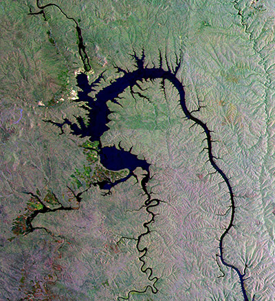
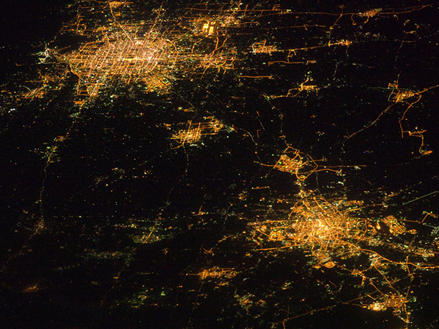
The gecko-shaped body of water featured in this radar image was formed by the Bratsk reservoir in south-eastern Siberia, Russia. The reservoir was formed in the 1960s by damming the Angara River to provide hydroelectric power. The dam, 125m high and 4,417m wide, was built near the city of Bratsk (white area in the upper left). Agricultural crops can be seen along the south-western side of the reservoir, including grains, potatoes and vegetablesPhotograph: Envisat/ESANight images have a way of dramatically revealing the amount of land development in metropolitan areas. This photograph features two of China’s most populous cities - Beijing and Tianjin – both in the north-eastern part of the country. The United Nations estimated the 2010 population of the Beijing metropolitan area to be approximately 12 million people, with the population of Tianjin estimated at more than 7 million. The smaller city of Langfang, located midway between Beijing and Tianjin, is also clearly visible, as are several smaller developments to the north-east. The dark regions are mainly agricultural fields, with wheat and corn being the major crops. Beijing regular grid pattern is clearly visible at image upper left; concentric rings of major roadways around the city have been added as the metropolitan area has expanded. Tianjin is a major trade centre linked to seaports on the Bohai GulfPhotograph: ISS/NASAThe 'Island of the Seven Mountains' (right top) or more precisely in Russian: 'having seven hills'. This uninhabited volcanic island is also an important nesting area for maritime birds of the North Pacific. Situated on the far end of the Aleutians, Semisopochnoi Island is simultaneously the most easterly and westerly point of the United States of America. Roughly 1,275 miles west-south-west of Anchorage, Alaska, Semisopochnoi has no native land mammals, so it is a natural nesting area for sea birds. But bird populations were decimated after Arctic foxes were introduced to the island for fur farming in the 19th century. In 1997, the last fox was removed from the island to allow the birds a safe refuge again. Part of the Alaska Maritime National Wildlife Refuge, the island now supports more than a million seabirds, particularly auklets, according to the National Audubon SocietyPhotograph: ETM/Landsat 7/NASA
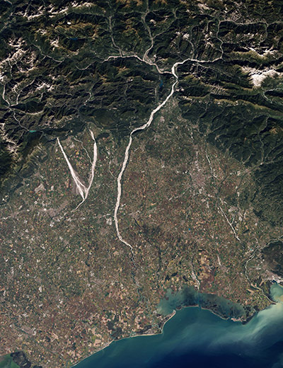
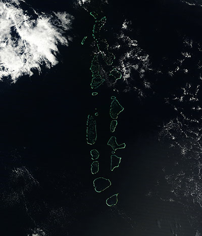
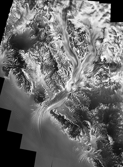
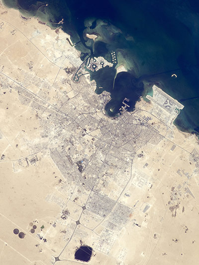
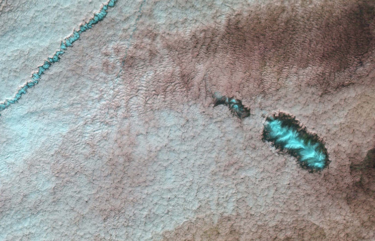
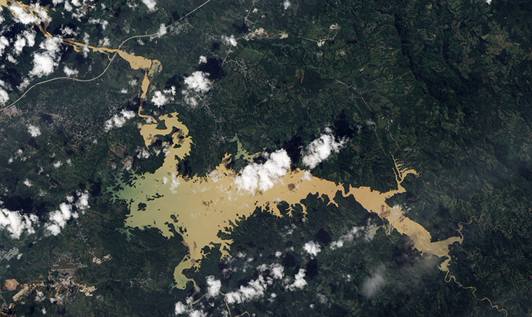
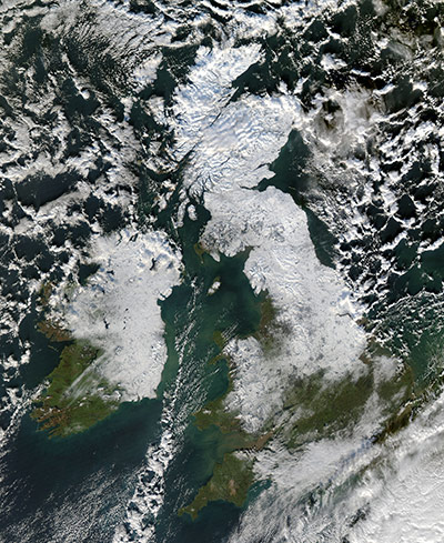
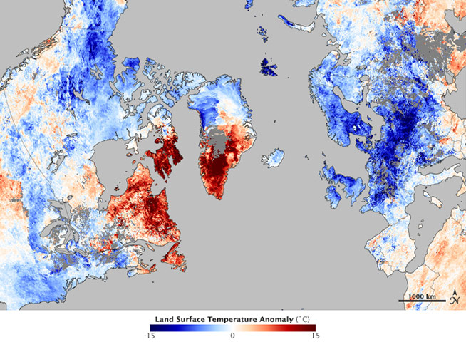
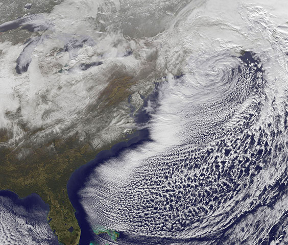
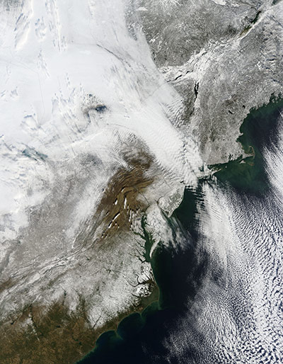
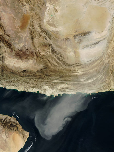
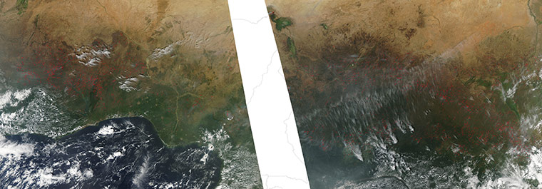
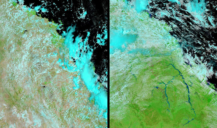
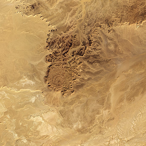
In north-eastern Italy, the Cellina, Meduna, and Tagliamento rivers flow in unison toward the Adriatic Sea. Fed by streams from nearby mountains, these gravel-bottomed rivers flow over a plain packed with farms. Rain falls frequently in the mountainous region north of these rivers, and some areas receive as much as 3,000mm of rain a year, making it one of the wettest places in Italy. Because much of that rain comes in heavy showers, significant quantities of mud and debris are eroded from the landscape into the rivers. The mountains upstream are also seismically active and prone to landslidesPhotograph: ETM/Landsat 7/NASAOccasionally during the winter, a large jet stream forms across the mid-Pacific, carrying a continuous flow of moisture from Hawaii to California, bringing heavy rain and snow to the Sierra Nevada for several days. This flow has been nicknamed 'The Pineapple Express'Photograph: GOES-11/NOAA/NASAOn a relatively clear day, the atolls and islands of the Maldives glow like a necklace of speckled jade beads floating on the deep blue waters of the northern Indian Ocean. The Maldives are an island nation made up of a chain of 1,192 small coral islands grouped into 26 clusters of atolls. It has a population of about 330,000. The capital and largest city is Male, with a population of about 80,000. The coral archipelago stretches in a north-south chain for almost 560 miles south-west of India, and sits upon a vast undersea mountain range. Arguably the lowest-lying country in the world, the average elevation is just 1m above sea levelPhotograph: MODIS/Terra/NASAFlowing movement of the Nimrod Glacier. The glacier is 135km long, working its way from the polar plateau through the Transantarctic mountains, a range of mountains that runs across the entire continent of Antarctica at heights of up to 4,500m. As it moves, it transports ice from eastern Antarctica to the Ross Ice Shelf. The glacier can move up to two metres a day. 'The flow speed is an important indicator in understanding the dynamics of the polar ice sheets,' says Dana Floricioiu from the DLR Remote Sensing Technology Institute. 'The polar regions play an important role in the Earth system changes influence climate models with a local impact on the properties of the polar oceans as well as a global impact on rising sea levels'Photograph: DLRThe old and new zones of Doha, the capital city of Qatar, are clearly visible from the International Space Station. The old city comprises the ancient bazaar, or Souq, near the harbour, which is still used for traditional Arab sailing vessels. Modern port facilities have sprung up to the east of the Souq. Qatar’s new artificial island, known as the Pearl-Qatar, is under construction with 32km of new coastline just offshore of West Bay Lagoon. The population of Qatar is almost 1.7 million, with nearly 75% being migrant workers from south and south-east Asia. Ninety per cent of Qatari citizens live in Doha. Qatar enjoys vast hydrocarbon wealth, thanks to the third largest gas reserves in the world. Consequently, the emirate has one of the highest per capita gross domestic products (GDP) in the worldPhotograph: ISS/NASARural West Virginia. This image shows the unique conditions in which holes in clouds form. When aeroplanes, particularly propeller aircraft, pass through the clouds, they disturb the air. As the air expands, it cools, and the supercooled water droplets in the clouds freeze into ice. These ice crystals act as seeds for other water droplets to freeze on to. Over time, the water clouds around the disturbed area disappear and an ice cloud grows. The clouds created in this manner take two different forms: hole-punch clouds and canals. The even cloud blanket is pale blue and pink, the warmer tones of water clouds. In the hole-punch clouds, however, we see the iridescent blue signature of ice, surrounded by a halo of clear sky. A similar blue streak from a canal runs across the top leftPhotograph: Landsat-5/NASAIn early December 2010, the Panama canal closed for only the third time in its 96-year history. Two artificial lakes linked to the canal, Gatún and Alajuela, reached their highest-recorded water levels, prompting authorities to close the canal for 17 hours on 8-9 December. Rains also forced thousands of residents to evacuate, washed out roads, and caused deadly landslides. Lago Alajuela serves as a reservoir for the Panama canal, which lies to the lake’s south-westPhotograph: ALI/EO-1/NASASnow partially covers Great Britain and Ireland on 8 December 2010. Snow extends from Northern Ireland southward past Dublin, and from Scotland southward into EnglandPhotograph: MODIS/Aqua/NASAThe first week of December was a chilly one for much of Europe and parts of the United States. This image shows the temperature of the land surface for December 3-10, 2010. Early December 2010 was much cooler than average in northern Europe and the eastern United States. Greenland and parts of northern Canada, however, were exceptionally warm. This temperature pattern was caused by the Arctic oscillation, a climate pattern that influences weather in the northern hemisphere. It describes the relationship between high air pressure in the mid-latitudes and low pressure over the Arctic. When the pressure systems are weak, the difference between them is small, and air from the Arctic flows south, while warmer air seeps north. This is referred to as a negative Arctic oscillationPhotograph: MODIS/Aqua/NASAA powerful low-pressure system brought blizzard conditions from northern New Jersey to Maine over Christmas weekend. This image shows the centre of the low off the Massachusetts coast and saw the snowfall it has left behind. Snowfall ranged from 1.5 inches in Atlanta, Georgia to more than a foot in various areas of New Jersey, New York and the New England statesPhotograph: GOES-13/NOAA/NASAA severe winter storm dropped up to 32 inches (80cm) of snow on parts of the north-eastern United States in late December 2010. The two-day storm brought especially heavy snow to parts of New York, New Jersey, Connecticut, and Massachusetts, where wind gusts up to 80mph (130kph) struck Cape Cod. Airlines cancelled hundreds of flights, and tens of thousands of residents lost power. With ambulances stranded in snow-clogged streets, 911 dispatchers in New York City were forced to resort to triage. On December 28, 2010 snow and clouds blend seamlessly, but can be distinguished by their different textures. The wide swath of uniform white that extends from Michigan and Ontario toward the south-east is a cloudbank. Under clear skies, snow cover from the storm creates a mottled appearancePhotograph: MODIS/Terra/NASAOne day after blowing over the borders between Iran, Afghanistan, and Pakistan, a massive dust plume migrated southward. On 5 December, 2010, the plume was over the Arabian Sea, headed for the south-eastern tip of the Arabian Peninsula. Typically arid, Pakistan experiences frequent dust storms, and the country holds sand seas that easily give rise to such events. Ironically, as dust blew over the eastern part of the country, areas along the Indus River were still coping with standing water left by the 2010 monsoon floods. In this image, the country to the west is Iran and Pakistan is to the east. Afghanistan borders the image on the north while Oman lies in the south-west corner. The Gulf of Oman separates the tan lands of Iran and Oman while the blue waters in the south-east corner are those of the Arabian SeaPhotograph: MODIS/Aqua/NASAHundreds of bright red hotspots form a speckled swath across the green lands of Central Africa in early December, 2010, marking the annual outbreak of fires that occur during the dry season in this region on December 9, 2010. The countries that contain hotspots are, from west to east: Cote d'Ivorie, Guinea (to the north with one hotspot), Burkin Faso, Ghana, Togo, Benin, Nigeria, Cameroon, Central Africa Republic and Chad. To the north, the arid land of Niger remains fire-free. Most of the hotspots are found in vegetated areas, colored in green, and relatively little fire burns in the tan, dry lands.Photograph: MODIS/Aqua/NASAAn area of Queensland the same size of France and Germany combined was flooded in December. More than 200,000 people in 20 towns and cities have been affected as high waters washed out roads, isolated entire towns, and forced thousands to evacuate. Coal and sugar exports were also affected. The flooding began in late December with the arrival of tropical storm Tasha. These images taken on 31 December 2010 (right), and 28 December 2009 (left), use a combination of infrared and visible light to increase the contrast between water and land. Compared to the image acquired a year earlier, the rivers between the coastal city of Rockhampton and the inland city of Emerald are all swollen. Water has not only filled frequently dry river valleys, but also pushed over riverbanks in some placesPhotograph: MODIS/Terra/NASAAlgeria's coast enjoys a Mediterranean climate with mild, wet winters. Inland, however, the terrain is mostly high desert, where mountains and transient rivers interrupt sand seas. In this dry, rugged terrain rests Tin Bider. Geologists suspect that Tin Bider is an impact crater and estimate that it was formed in the past 70m years, perhaps in the late cretaceous or early tertiary period. Spanning 6km (4 miles), the structure sits at the southern end of a range of hills. The desert surface appears in shades of tan, camel, beige, and brown. North-facing slopes are in shadow due to the angle of sunlight from the south. That angle creates an optical illusion, making the crater look as if it sits at a lower elevation than the surrounding land. But Tin Bider actually rises above the land to the south, east, and westPhotograph: ALI/EO-1/NASA
Sign up to read this article
Read news from 100’s of titles, curated specifically for you.