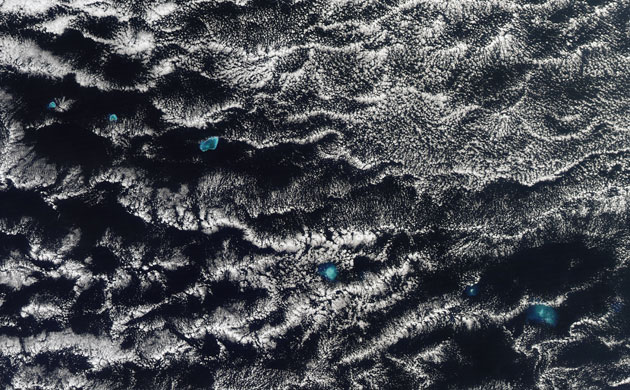
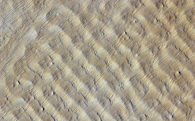
Like tiny blue jewels, the western Hawaiian islands glow amongst the clouds over the Pacific Ocean, on December 7, 2009. The Hawaiian islands are in the north Pacific - the larger, eastern islands are probably more well-known, but there are actually 8 major islands, as well as many smaller islands and several atolls. Though Hawaii is a US state, the island chain is actually located 1860 miles from the nearest continent. The islands are actually the exposed peaks of a volcanic, undersea mountain range.Photograph: Aqua/MODIS/guardian.co.ukTens of thousands of people living within the danger zone (up to 8 kilometers away) of Mayon Volcano in the Philippines were forced to evacuate to emergency shelters in mid-December 2009 as small earthquakes, incandescent lava at the summit, and minor ash falls suggested a major eruption was on the way, on December 15, 2009. On the evening of December 14, the local volcano observatory raised the alert level to Level 3, which means magma is close to the crater and hazardous explosive eruption is imminent. According to local news reports from December 16, fragments of lava were continuously detaching from the lava filing the crater and cascading down slope up to 3 kilometers. Lava flows reached several hundred meters from the summit, but they were still confined to ravines. Photograph: EO-1/guardian.co.ukThis detailed astronaut photograph highlights sand dunes in the Fachi-Bilma erg (sand sea) in the central-eastern part of the Tenéré Desert. The TenŽrŽ occupies much of southeastern Niger and is considered to be part of the larger Sahara Desert, which stretches across northern Africa. Much of the Sahara is comprised of ergs; with an area of approximately 150,000 square kilometers (57,915 square miles), the Fachi-Bilma is one of the larger sand seas. Photograph: ISS/guardian.co.uk
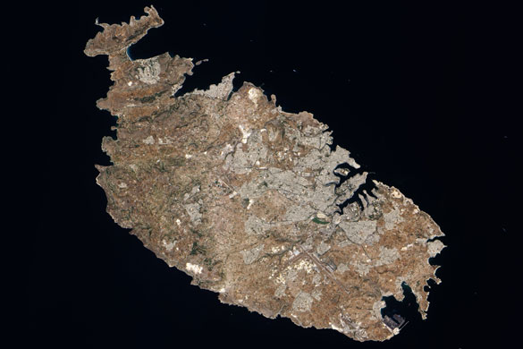
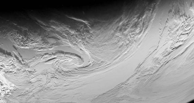
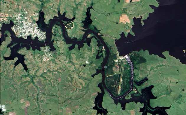
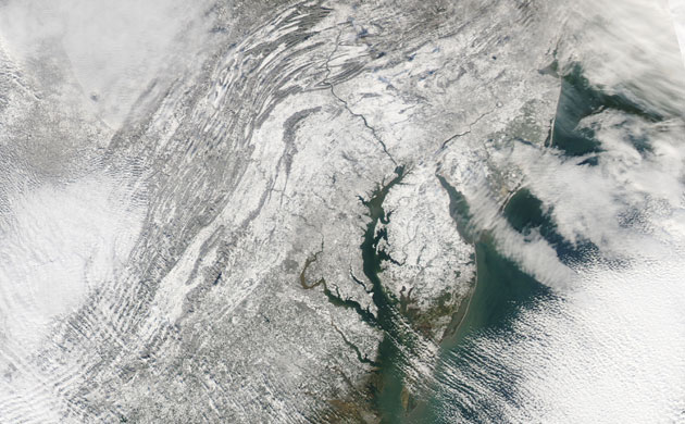
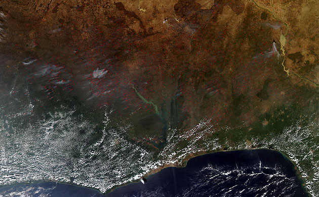
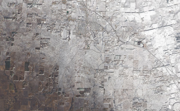
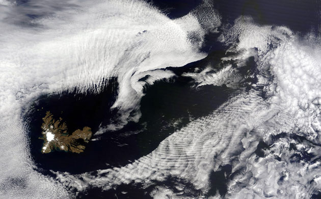
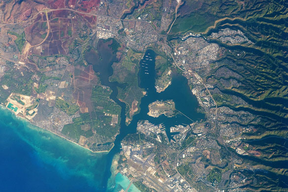
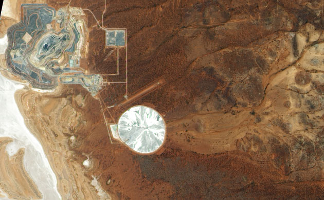
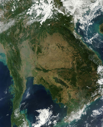
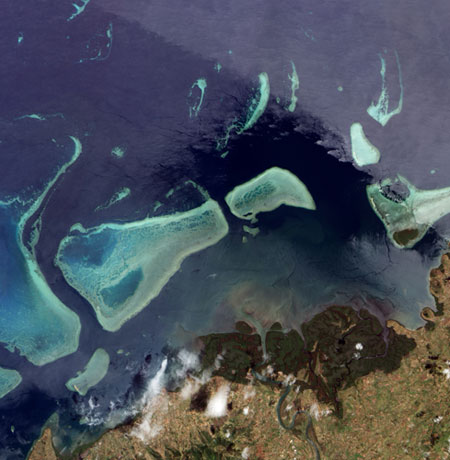
The Calabria region of southern Italy—the toe of Italy’s “boot”—outlined by the Ionian and Tyrrhenian Seas to the southeast and northwest respectively. The water surfaces present a mirror-like appearance due to sunglint. This phenomenon is caused by sunlight reflecting off the water surface directly back towards the astronaut observer on board the International Space Station (ISS). The ISS was located over northwestern Romania, approximately 1,040 kilometers to the northeast of Calabria, when this image was taken. The Calabrian Peninsula appears shortened and distorted due to the extreme sideways viewing angle from the ISS. Such a perspective is termed oblique, as opposed to a nadir view, in which the astronaut is looking directly downwards towards the Earth’s surface from the ISS. Patchy, highly textured cumulus clouds are present at lower altitudes, while grey altostratus clouds are stretched out by prevailing winds at higher altitudes.Photograph: ISS/guardian.co.ukThe largest island in the Republic of Malta archipelago, the island of Malta spans some 27 kilometers (17 miles) from northwest to southeast. The island sits in the Mediterranean Sea, south of Sicily. Graced with numerous bays serving as natural harbors, Malta may originally have been reached by raft 7,000 years ago, and it has been inhabited ever since. Malta is not only one of Europe's smallest countries, but also one of its most densely populated. Gray cityscape stretches over much of the island, centered around the bustling port city of Valletta on the northeast coast. Malta's winters are usually mild, but occasional wintertime frosts as well as high summer temperatures limit vegetation growth. Only a few patches of deep green appear in this shot, mostly on the western third of the island. The islandÕs terrain consists primarily of rocky, flat lowlands. Malta has no permanent rivers or lakes, but temporary waterways can form after heavy rains.Photograph: EO-1/guardian.co.ukClouds in an anticyclone over the South Pacific imaged with the orange filter of the narrow-angle camera. This image is shown in a logarithmic scale to bring out details in the varying light intensity.Photograph: guardian.co.ukThe city named Paso de Los Toros sits just north of the Rio Negro in central Uruguay. Flowing from east to west, the Rio Negro;s course takes it through oxbow curves on either side of the city, surrounding Paso de Los Toros on three sides. Normally, the river's banks are smooth and well-defined. The torrential rains that struck South America in late November 2009, however, pushed the Rio Negro well above its banks and broadened the channels of the smaller water bodies flowing into the river.Photograph: EO-1/guardian.co.ukThe Mid-Atlantic states were completely white on Sunday, December 20, 2009, in the wake of a record-breaking snow storm. The storm deposited between 12 and 30 inches of snow in Virginia, Maryland, and Washington, D.C. on December 19, according to the National Weather Service. For many locations, the snowfall totals broke records for the most snow to fall in a single December day. The snow highlights the courses of the Potomac and Susquehanna Rivers from the Appalachian Mountains to the Chesapeake Bay. The ridges and valleys of the Appalachian Mountains are similarly highlighted. The forested peaks are darker than the snow-covered valleys. The massive snow storm was a Nor’easter, a powerful storm characterized by a strong low-pressure center that forms in the Gulf of Mexico or the Atlantic Ocean and moves northward up the Eastern seaboard.Photograph: Aqua/MODIS/guardian.co.ukAgricultural fires burned across much of western Africa on December 6, 2009. Red outlines indicate hotspots associated with high surface temperatures, and the fires range from Cote d'Ivoire in the west to Nigeria in the east. Although agricultural burning such as this is not necessarily immediately hazardous, it can have a major impact on air quality and human health, climate, and natural resources.Photograph: Aqua/MODIS/guardian.co.ukThe late-December snowstorm that left a swath of white across the south-central United States on December 25, 2009, covered the Texan town of Snyder. Taken along the southwestern edge of the snow cover, this picture shows an apparent gradient of snow thickness. Snow cover appears most opaque in the upper right corner of the image, and gradually thins toward the south and west. A combination of snow, bare ground, and the Sun's low angle accentuates differences in land use. Grids of major roadways and side streets indicate Snyder;s city limits. Immediately southeast of town, a cluster of circles and semicircles suggests center-pivot irrigation systems. Surrounding the town, rectangular and circular shapes indicate cropland. East of town, a highway runs northwest-southeast through the area.Photograph: EO-1/guardian.co.ukThis image shows the Kerguelen Islands on December 21, 2009. The Kerguelen Islands sit in the southern Indian Ocean, southeast of Madagasgar, but north of Antarctica. This island chain is actually a French Territory. There are no native inhabitants, but a small staff of scientists and researchers does stay there..The main island, Grande Terre, is mostly what is visible in this image, though the archipelago does include 300 or so smaller islands. Grande Terre seems to contribute to interesting cloud formations, as the island interacts with the air flowing over it. Nearby are wave clouds, which are created when stable air is disturbed, causing air to move along the disturbance, like waves in a pond. If the layer of stable air is humid, where the air flows up, a cloud forms at the crest. Where it flows down, the cloud evaporates, giving the clouds the rippled pattern. In August of 2009, there were Ship-wave-clouds.Photograph: Terra/MODIS/guardian.co.ukThe southern coastline of the Hawaiian island Oahu, including Pearl Harbor. On December 7, 1941, 68 years ago, a surprise attack by the Japanese Navy on Pearl Harbor and other targets on the island of Oahu precipitated the entry of the United States into World War II. Today, Pearl Harbor is still in use as a major United States Navy installation, and along with Honolulu, it is one of the most heavily developed parts of the island. The urban areas of Waipahu, Pearl City, and Aliamanu border the harbor to the northwest, north, and east. The built-up areas, recognizable by linear streets and white rooftops, contrast sharply with the reddish volcanic soils and green vegetation on the surrounding hills.Photograph: ISS/guardian.co.ukRoughly 55 kilometers (35 miles) south of Laverton, Western Australia, lies the Sunrise Dam Gold Mine. A gold deposit was discovered in the area in 1988, and by 1995, the mine was open for business. Started as an open pit mine, the operation expanded to include underground mining in 2003. The mine produces roughly 460,000 ounces of gold each year, according to AngloGold Ashanti, which operates the mine. The main pitÕs terraced landscape appears in shades of gray in the left half of this image, and what appears to be a smaller, rectangular pit appears on the right. In 2008, the central pit at Sunrise Dam reportedly reached a depth of 440 meters (1,445 feet). The straight line running diagonally through the lower right quadrant of the image is probably a landing strip.Photograph: EO-1/guardian.co.uk Indochina on December 24, 2009. Scattered fires (red dots) burn across the region. At upper left is Thailand, in the center is Cambodia, and along the right edge is Vietnam. In Thailand, the city of Bangkok appears as a large grayish patch along the coast of the northernmost part of the Gulf of Thailand. In Cambodia, the Tonlé Sap Lake appears deep green and brown. The river running southward through Cambodia and emptying into the South China Sea is the Mekong River.Photograph: Terra/MODIS/guardian.co.ukDeep green forest on land and the delicate turquoise coral reef in the ocean mirror each other in this true-color image from December 18, 2009. Both systems provide a significant habitat for a wide range of life, and both depend on the other for their healthy existence. The forest, a mangove forest, defines the delta of the Ba River on the north side of Viti Levu, Fiji's main island. Such mangrove forests serve as the interface between river and sea across Fiji and in many other places in the world. The trees grow with roots submerged in the semi-salty water near the shore, but they grow best in sheltered areas, where the ocean's battering waves are minimal. In this case, the coral reef offshore provides a break, slowing incoming waves. The mangrove forest, in turn, protects the reef from sediment and extensive algal blooms. The tangle of roots catches sediment and nitrogen from the river, acting as a natural filter.Photograph: EO1/guardian.co.ukThe snow-covered Nunavut territory in the Canadian Arctic. The icy body of water is Fox Basin, a shallow extension of the Atlantic Ocean. Due to the low elevation of the sun at this time of the year, the top of the image appears very dark. The position of the low sun gives the clouds in the upper part of the image a reddish tint.Photograph: AATSR/Envisat/guardian.co.uk
Sign up to read this article
Read news from 100’s of titles, curated specifically for you.