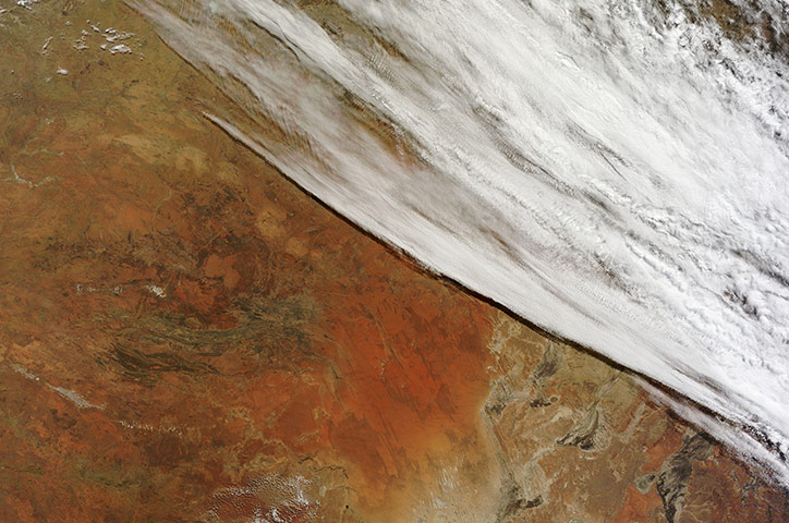
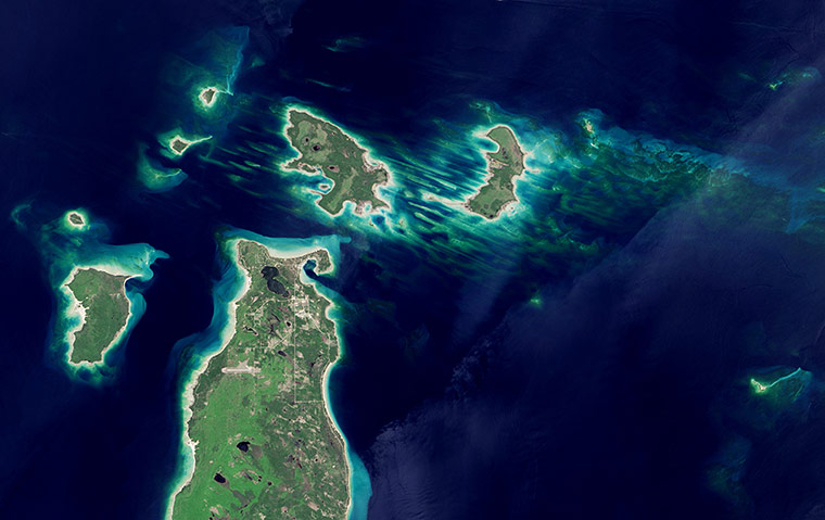
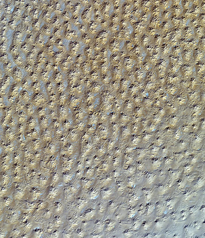
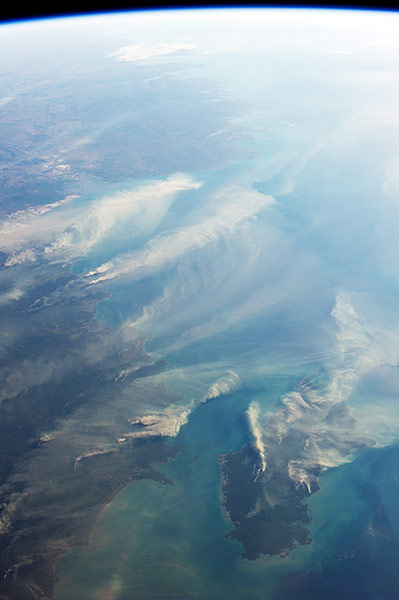
In late July 2013, a low pressure system off Australia’s south-east coast and moist onshore winds combined to create unsettled weather across central Australia – and a striking image of a broad cloud band across the stark winter landscape Photograph: MODIS/Terra/NASAOver thousands of years, retreating glaciers scoured and carved out much of the basin that now holds Lake Michigan. But in some parts of the lake, patches of erosion-resistant rock still protrude above the water. A cluster of small islands in the far northern reaches of the lake – the Beaver Island archipelago – are composed of limestone bedrock covered with a layer of sand and gravel (glacial 'till'). This image was the subject of August's puzzler question, which offers up a satellite image for readers to identify each month Photograph: OLI/Landsat 8/NASARadially symmetrical, star dunes are pyramidal sand mounds with slipfaces on three or more arms that radiate from the high centre of the mound. They tend to accumulate in areas with multidirectional wind regimes. Star dunes grow upward rather than laterally. They dominate the Grand Erg Oriental of the Algerian SaharaPhotograph: ASTER/Terra/NASA
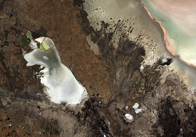
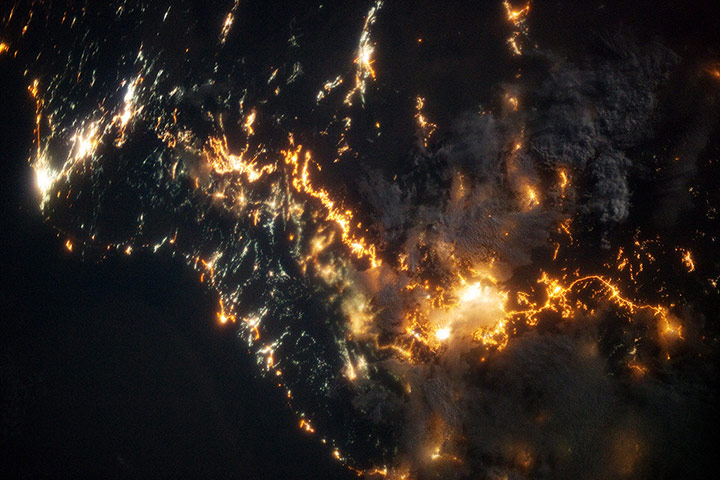
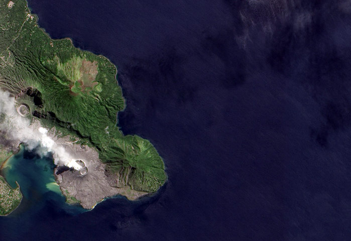
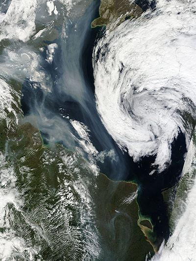
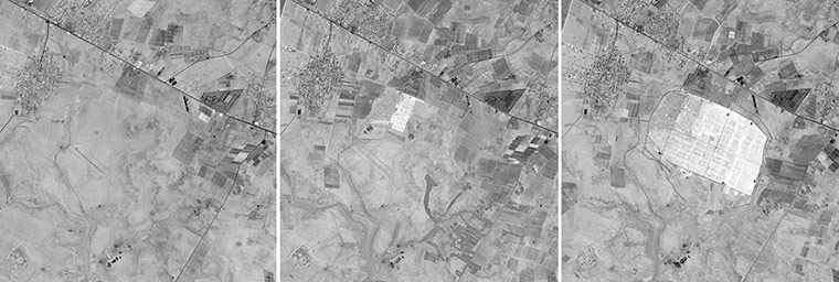
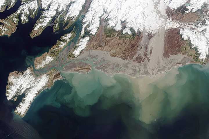
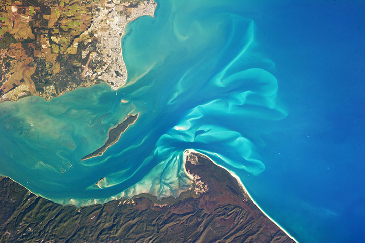
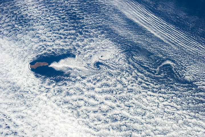
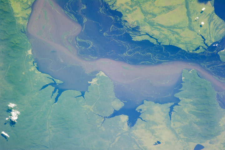
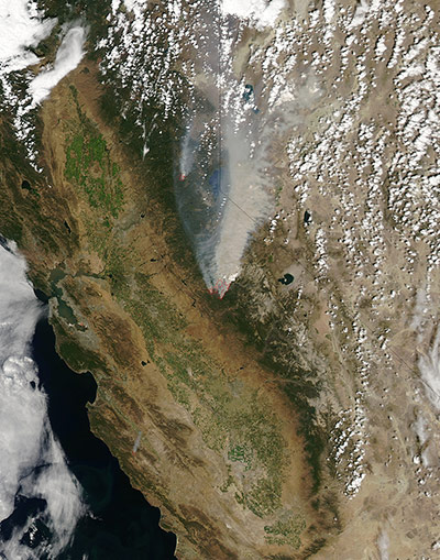
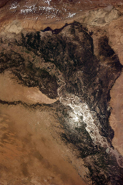
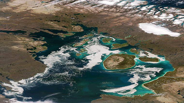
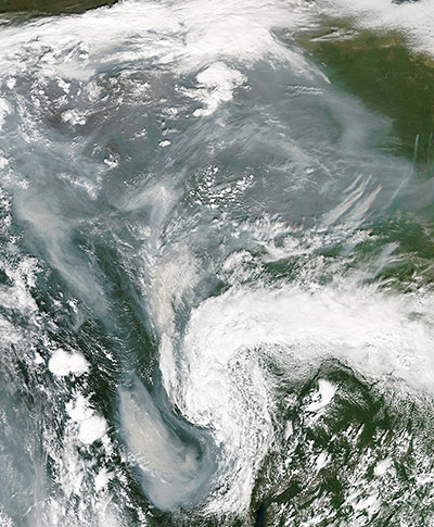
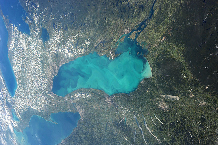
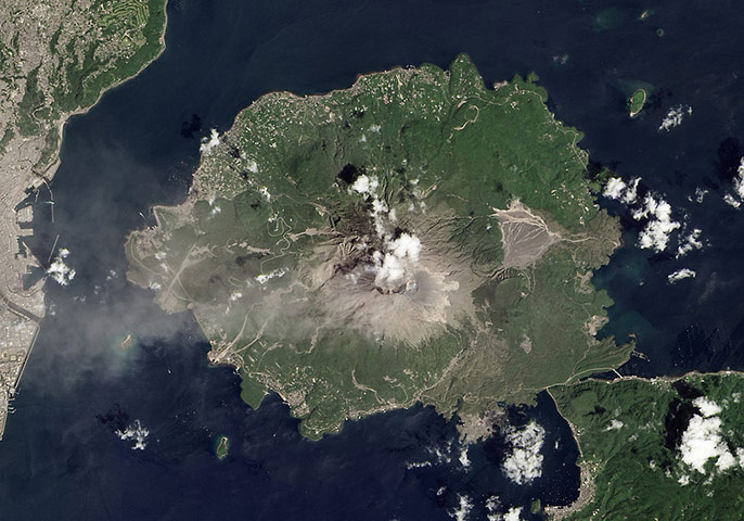
This image was taken over Anatolia’s dry, central plateau in Turkey. On the left side we can see the whole of Lake Tersakan, with part of Lake Tuz in the upper right corner. Lake Tuz is Turkey’s second largest lake, as well as one of the largest saline lakes in the world. During the summer months, however, the lakewater recedes to expose a thick layer of salt. The bright white surface during these dry summer months has been used by Earth-observing satellites to calibrate their sensors for the colour white – much like how you would adjust a camera’s white balance settingPhotograph: ALOS/JAXA/ESAThe coastline of south-western Saudi Arabia. Patchy cloud cover partially obscures and blurs the city lights, especially in the vicinity of Khamis Mushait and Abha. While much of the country is lightly populated desert – and relatively dark at night due to lack of city and roadway lights – the south-western coastal region has a more moderate climate and several large cities. Three brightly lit urban centres are visible at image top left: Jeddah, Mecca, and TaifPhotograph: ISS/NASATavurvur Cone emitted an ash plume on 6 August. Located within the Rabaul Caldera on New Britain Island, Tavurvur began emitting ash in January 2013 after a few years of relative quietPhotograph: ALI/EO-1/NASAIn late July 2013, numerous wildfires burned through boreal forests in northern Canada and a large smoke plume spread south over Hudson BayPhotograph: MODIS/Aqua/NASAIn a little over a year, the Zaatari refugee camp has become Jordan’s fourth largest city and the world’s second-largest refugee camp. Located in northern Jordan near the border with Syria, it opened in July 2012 and now houses roughly 129,000 people, according to the United Nations. Here the three pictures of area around the camp are seen on May 30, 2009 (left), September 27, 2012 (middle), and July 19, 2013 (right)Photograph: ASTER/Terra/NASANamed for the ore deposits found upstream, the Copper River drains an area of more than 24,000 square miles and flows into the Gulf of Alaska. The Childs and Miles glaciers drain into the river, grinding on the bedrock below, creating what scientists refer to as 'glacial flour'. That sediment is a good source of iron and nutrients for phytoplankton and marine plants, which in turn support abundant salmon runsPhotograph: OLI/Landsat 8/NASAHundreds of millions of tonnes of dust are picked up from the deserts of Africa and blown across the Atlantic Ocean each year. That dust helps build beaches in the Caribbean and fertilises soils in the Amazon. It affects air quality in North and South America. And some say dust storms might play a role in the suppression of hurricanes and the decline of coral reefs. The image helps reveal wind patterns (such as trade winds) that steer plumes and clouds. At several points, dust stretched continuously from North Africa to South AmericaPhotograph: VIIRS/Suomi NPP/NASAAstronaut Karen Nyberg shot this photograph on 5 August 2013, while looking west across the Timor Sea. Note how the smoke near Darwin is blown by south-easterly winds (pushing it to the north-west), while the winds over Melville Island are mostly blowing to the south-west (influenced by the interaction of land and sea breezes and other local effects). Many of the fires on Melville Island were likely prescribed burns, designed to clear brush and dry fuel to prevent more serious wildfire as the weather warms. The fires near Darwin, however, were probably wildfires. Australia’s Northern Territory is in the midst of the dry season that lasts from roughly May to September, and rainfall barely exceeds 10 mm for the month in AugustPhotograph: ISS/NASAFrance on a sunny late summer day. Near the upper cenre of the image a grey, roughly oval smudge marks the city of Paris, the capital city of France. The central city covers approximately 105 square km with a 2009 population over 2.2 million people, while the metropolitan area covers 2,300 square km, and is home to greater than 12 million people. Situated on the River Seine, the site has been occupied in one form or another for 90,000 years. The body of water to the north-west of France is the English Channel, separating coastal France from England. To the south-west is the Bay of Biscay, which lies along the French coast from Brest to the Spanish border, then follows the northern coast of Spain. To the south-east, several peaks of the Alps remain covered with snow. Photograph: NASAThe Great Sandy Strait is an estuary that separates the mainland coastline of the state of Queensland, Australia, from neighboring Fraser Island. The mainland side of the strait includes the city of Hervey Bay. A small, vegetated island and shallow sand bars of the Great Sandy Strait are visible. A small, bright white exposure of sand is visible above the water level near the center of the image, while submerged sands appear as flowing, bright blue ribbons. Hervey Bay was once a major freighting centre for the sugar cane industry, but now the local economy is largely based on tourism, with whale watching a popular attraction. Fraser Island is the world’s largest sand island and a World Heritage sitePhotograph: ISS/NASAGuadalupe Island is a volcanic edifice that is 35km long and is situated 240km off the coast of Mexico’s Baja California peninsula. Obstacles of any kind can set up such vortices – known technically as a Von Karman vortex street – from islands to craters to chimneys. The size of each swirl can be judged from the length of the island. Under ideal conditions, clouds make the swirls visible. However, a vortex street will only form under certain conditions of air speed, atmospheric stability, and obstacle size. Conditions are ideal for production of vortex streets in the vicinity of Guadalupe Island, which is known to produce them almost every day in June, July and August. The phenomenon is named after Theodore von Karman, a Hungarian-American engineer and fluid mechanics expert. Also visible at image top right is a series of parallel cloud lines. Known colloquially as “gravity waves,” these are ripples at the boundary between atmospheric layers of slightly different densityPhotograph: ISS/NASAFloods on the Amur (Heilongjiang) River on 21 August 2013. Water levels on the river, which forms a border between north-eastern China and Russia, reached 7.6m on 29 August. The floods are the worst in 120 years for the Russian far east, and they have already surpassed records in ChinaPhotograph: ISS/NASAOn 22 August 2013, the drought-fueled Rim fire burning in central California, near Yosemite national park. On 17 August, the fast-moving fire had already charred more than 100,000 acres (40,000 hectares) by 23 August, despite the efforts of more than 2,000 firefighters. Hundreds of people were forced to evacuate their homes, and roads in the area were closed. As of 23 August, no structures had been reported destroyed, but the fire threatened the towns of Groveland and Pine Mountain LakePhotograph: MODIS/Aqua/NASAOne of the Expedition 36 crew members aboard the International Space Station photographed this image of the Indus Valley in Pakistan with its huge August floods brilliantly visible in sunglintPhotograph: ISS/NASAThe remnants of sea ice along the Northwestern Passage in northern Canada are seen swirling with the blue green of phytoplankton in this image from the Suomi NPP VIIRS sensor Photograph: VIIRS/Suomi NPP/NOAA/NASASummer in central Russia brings a greening of the land as fields fill with growing grass and crops, and the trees of the taiga burst forth in full leaf, but the summer of 2013 has brought a great graying to the skies from an ocean of smoke so thick that it hides the verdant land from viewPhotograph: MODIS/Aqua/NASAThis photograph highlights a late-summer 'whiting event' visible across much of Lake Ontario (one of North America’s Great Lakes). Such events commonly occur in late summer and are caused by changes in water temperature, which allows fine particles of calcium carbonate to form in the water column. Increased photosynthesis by phytoplankton and other microscopic marine life can also reduce the amount of carbon dioxide in the water column, changing the acidity and allowing calcium carbonate to form. These particles of calcium carbonate cause the characteristic lightening of the water colour observed. Lake Ontario – like the Great Lakes Erie, Huron, and Superior – is roughly divided between the United States and Canada. The USA side of Lake Ontario has its shoreline in the state of New York, while its Canadian shoreline lies within the province of Ontario. The city of Kingston, Ontario, is visible near the Saint Lawrence River outflow from the lakePhotograph: ISS/NASAAlthough Japan’s Sakura-jima volcano is one of the most active in the world, it rarely makes headlines. One or two small explosions typically occur every few days, with effects no greater than a light dusting of ash on the surrounding cities. On August 18 2013, a large eruption sent ash 20,000 feet (6,000m) above Kagoshima Bay, breaking the established pattern. It was possibly the largest eruption ever from the Showa Crater, which formed in 1946Photograph: Landsat 8/OLI/NASA
Sign up to read this article
Read news from 100’s of titles, curated specifically for you.