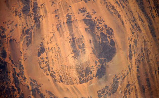
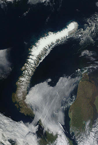
The impact of an asteroid or comet several hundred million years ago left scars in the landscape that are still visible in this satellite image of the Aorounga crater, in the Sahara desert of northern Chad. The concentric ring structure is thought to be 345-370m years old and is one of the best-preserved impact structures in the world Photograph: NASANovaya Zemlya is an Arctic archipelago off the coast of the Russian Federation. An extension of the Ural mountains, this mountainous archipelago has an average altitude of roughly 1,000m (3,280ft) above sea level, and glaciers cover much of the northern island. In the latter half of the 20th century, Novaya Zemlya was used as a nuclear test site. The sparsely vegetated land appears in shades of beige and icy white. A narrow band of sea ice hugs the south-eastern coast, and smaller pieces of sea ice float off the northern island's north-eastern tip. Before the turn of the 20th century, Arctic sea ice used to linger along the coast of Novaya Zemlya's larger island each July. After the turn of the century, however, increased summertime melt made open ocean more commonPhotograph: Terra/MODIS/NASAArgentina's largest lake, Laguna Mar Chiquita, is a shallow salt lake that grows and shrinks significantly depending on the weather. In 2009, Argentina was still recovering from severe drought, and the lake shrank. During August, the northern shore was entirely exposed and the low water level exposed fine lakebed sediment, which is easily lifted in the wind. Two thick plumes of dust blew from the northern shore across more than 200km. Red dots on this image outline the locations of fires. Many of the fires are located in agricultural land, the tan and green squares north of the lake. Like the lake, these farms were likely impacted by droughtPhotograph: Aqua/MODIS/NASA
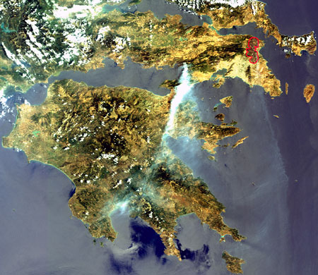
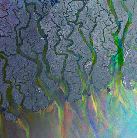
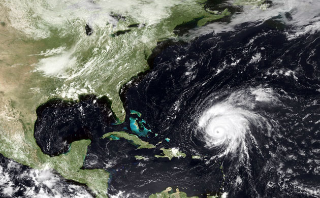
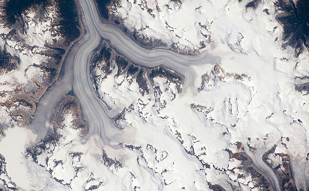
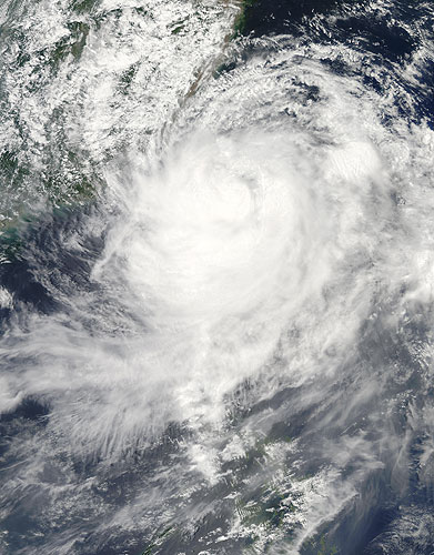
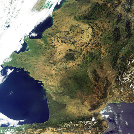
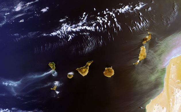
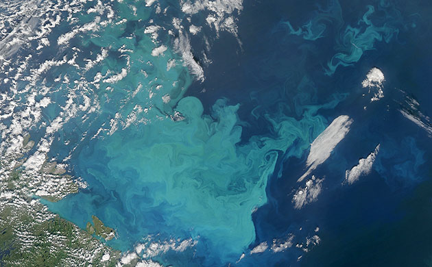
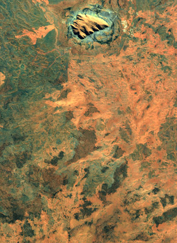
Heavy monsoon rains arrived in Bangladesh in August, swelling the Brahmaputra river and many of its tributaries. The overdue rains left hundreds of thousands of residents stranded, and flooded tens of thousands of hectares of crops. Nasa’s Aqua satellite captured the bottom image on 26 August 2009, and the top image a month earlier on 23 July. Both images use a combination of infrared and visible light to increase the contrast between water and land and show a stretch of the Brahmaputra river as it passes through eastern India and neighbouring BangladeshPhotograph: Aqua/MODIS/NASARainforests are not always wet and rainy. The world's largest rainforest, the Amazon, actually has a dry season when the clouds clear and sunlight drenches the trees. It is during this period that the forest growth is the greatest. In June, July, and August , the thick blanket of clouds brought in by large-scale patterns in the atmosphere disappear, and smaller-scale processes that influence the weather become apparent. This image, captured on 19 August, shows how the forest and the atmosphere interacted to create a uniform layer of 'popcorn' clouds one afternoonPhotograph: Aqua/MODIS/NASAGreece, 24 August. A large smoke plume is visible west of Athens, pushed south by strong winds. Some light smoke is also visible south of Athens and comes from the area which was under threat days earlier previous days. The burned areas appear in dark and have been highlighted by a red linePhotograph: MERIS/ESAThis Envisat image shows the Ganges delta in the south Asia area of Bangladesh and India. The delta plain, about 350km wide along the Bay of Bengal, is formed by the confluence of the rivers Ganges, the Brahmaputra and Meghna. The colour effect comes from variations in the Earth's surface that occurred when three Envisat radar acquisitions taken over the same area at different times were combinedPhotograph: Envisat/ESAIn this satellite image, taken on 20 August, hurricane Bill is seen in the Atlantic Ocean off the coast of North America Photograph: NOAA/Getty ImagesMount Hood is located within the Cascade range of the western United States, and it is the highest peak in Oregon at 3,426m. The Cascade Range is characterised by a line of volcanoes associated with a slab of oceanic crust that is descending underneath the westward-moving, continental crust of North America. Magma generated by this process rises upward through the crust and feeds a line of active volcanoes that extends from northern California in the United States to southern British Columbia in Canada. While hot springs and steam vents are still active on Mount Hood, the last eruption from the volcano occurred in 1866. The volcano is considered dormant, but still actively monitoredPhotograph: NASAThe Heiltskuk (also written Ha-Iltzuk) ice field covers an area of approximately 3,600 sq km in the southern Coast mountains of British Columbia. This detailed astronaut photograph shows the ice field mostly covered by snow across the upper mountain slopes, and two major valley glaciers that extend from it. Valley glaciers are large masses of slowly flowing ice and debris that move downhill, carving out wide U-shaped valleys in the processPhotograph: NASATyphoon Morakot bore down on the island of Taiwan on 7 August. Morakot was a category two storm with winds of about 160kph and moved slowly north-west over Taiwan. As a category two storm, Morakot does not possess a distinctive eye, but it still large, with spiralling clouds stretching from the Philippines to Japan's southern islandsPhotograph: Aqua/MODIS/NASAThis image, acquired on 15 August, shows a cloud-free France. France's topography is one of the most varied in Europe, ranging from broad plains to western Europe's highest peak, Mont Blanc, at 4,810mPhotograph: MERIS/Envisat/ESAThis image, acquired on 1 August, captures a large plume of smoke rising from two forest fires that burned out of control on the southern tip of the Spanish Canary Island of La Palma (top left). Seven larger islands and a few smaller ones make up the Canary Island archipelago, located some 95km from the north-west coast of Africa (bottom right) in the Atlantic Ocean. The larger islands are (visible left to right): La Palma, El Hierro, La Gomera, Tenerife, Gran Canaria, Fuerteventura and LanzarotePhotograph: Envisat/ESAIn the chilly waters of the Barents Sea, off the north-western corner of Russia, the ocean switched on its carbon dioxide vacuum during August: a giant bloom of single-celled, plant-like organisms called phytoplankton. During these blooms, which can cover thousands of square kilometres of the surface of the ocean, a litre of seawater may contain a billion or more phytoplankton cells, each one a microscopic chemical factory that vacuums carbon dioxide out of the surrounding seawater and uses photosynthesis to turn it into stored chemical energy. The milky-blue colour that dominates the bloom suggests that it contains large numbers of coccolithophores, phytoplankton that arm themselves with tiny calcium carbonate (chalk) scales. Chlorophyll and other light-harvesting pigments from other species of phytoplankton can add darker blues, greens, and reddish-browns to the bloomPhotograph: MODIS/NASAThe rock formation Uluru, Australia, as seen from spacePhotograph: Proba/ESA
Sign up to read this article
Read news from 100’s of titles, curated specifically for you.