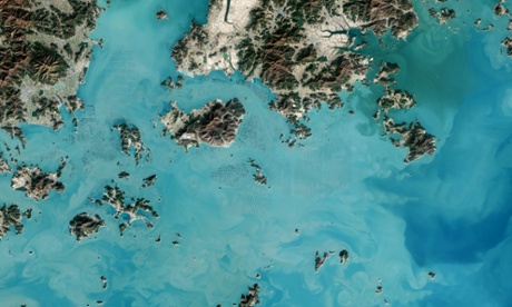
The dark squares that make up the checkerboard pattern in this image are fields of seaweed. Along the south coast of South Korea, seaweed is often grown on ropes, which are held near the surface with buoys. This technique ensures that the seaweed stays close enough to the surface to get enough light during high tide but doesn’t scrape against the bottom during low tide. Home to a thriving aquaculture industry, the south coast of South Korea produces about 90% of the country’s seaweed crop. Seaweed farming has a light environmental footprint because it does not require fresh water or fertiliser.
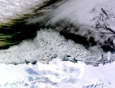
This is a natural-colour image of sea ice off Antarctica’s Princess Astrid coast. White areas close to the continent are sea ice, while those in the northeast corner of the image are clouds. The image was acquired after Antarctic sea ice had passed its annual minimum extent reached on 20 February and had resumed expansion towards its maximum extent, usually reached in September.
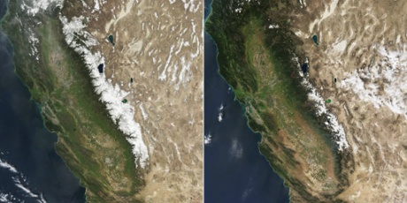
In California and other states, snowfall is critical to fresh water supplies. In the mostly arid climate west of the Rockies, snow cover on the mountains in winter is a liquid checking account that is usually drawn down each summer and fall when rainfall is sparse. As California heads into another year of drought, the snow-white bank account in the mountains is unusually low on funds. The image on the left was taken in March 2010 with average winter snowfall in the region. The second image was acquired in March this year which shows a significantly depleted snow cover.
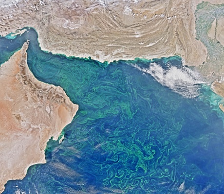
Phytoplankton bloom in the Arabian Sea. Winter is the prime season to see filaments of phytoplankton twist and curl. Seasonal wind patterns have a large effect on blooms in the region. The winter monsoon brings a reversal of wind direction – from southwesterly to northeasterly – which stirs up nutrients that help phytoplankton thrive.
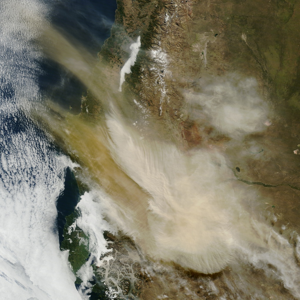
Calbuco volcano in southern Chile erupts on 22 April, the first time since 1972. An ash cloud rose nine miles (50,000 ft) above the volcano, menacing the nearby communities of Puerto Montt in Chile and San Carlos de Bariloche in Argentina. About 1,500 to 2,000 people were evacuated from a 12-mile radius around the volcano.
Ash and gas plume rises up from Calbuco volcano in southern Chile at midday on 24 April. The Chile’s National Geology and Mining Service said volcanic activity continues and the volcano has entered ‘an unstable phase’ with the area experiencing tremors and ash emissions.
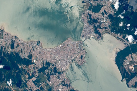
Florianópolis, southern Brazilian port city: the east side (top right) and west side (lower left) are joined by bridges spanning the 400-meter-wide narrows. The city has one of the highest-quality-of-life indices in Brazil. The top image is illuminated by the partial reflection of the sun. This sunglint reveals many details in the water surface, especially wind streaks and boat wakes. The water south of the city is far brighter than to the north, probably because the hills of the city protect water surfaces from the wind on the leeward side, leading to calmer water and a brighter reflection.
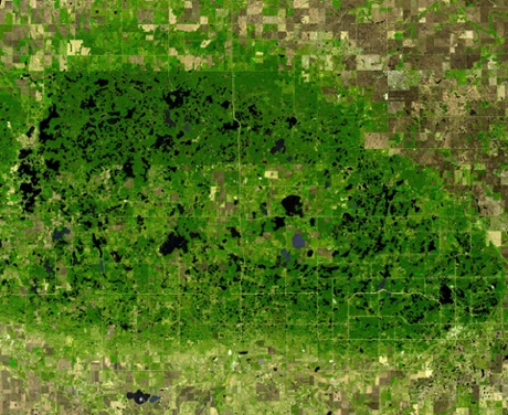
The Turtle Mountains straddle the US-Canada border in central North Dakota. Underlain by 55-million-year old sandstones and shales of the Cannonball Formation, the upland surface was sculpted by glaciations. Due to the mountain’s 150m elevation above the surrounding lowlands, glacial ice tended to stagnate, forming thousands of lakes and sloughs.
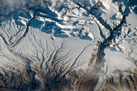
Himalaya peaks near India-China border cast strong evening shadows on the snow. The mountains host glaciers. For millions of years, water has eroded rock from these high mountains and deposited the sediment in ancient, broad alluvial fans. Snow cover highlights these strikingly smooth surfaces, while a trellis-like network of gullies cuts through and casts sinuous shadows. The largest river in the scene has cut a 500-meter-deep canyon (right). Although the rivers drain northward from the Himalayas, they ultimately flow back to the south. The streams accumulate in the Sutlej river and pass through the mountains towards the lowlands of Pakistan and empty in the Arabian Sea.
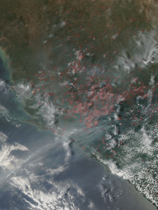
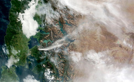
Widespread agricultural burning to manage land continued throughout Sierra Leone in late March. Farmers often use fire to return nutrients to the soil and to clear the ground of unwanted plants. While fire helps enhance crops and grasses for pasture, it also produces polluting smoke. Each hot spot, (red mark) is an area with temperatures higher than the background. When accompanied by plumes of smoke, as in this image, such hot spots are diagnostic for fire.
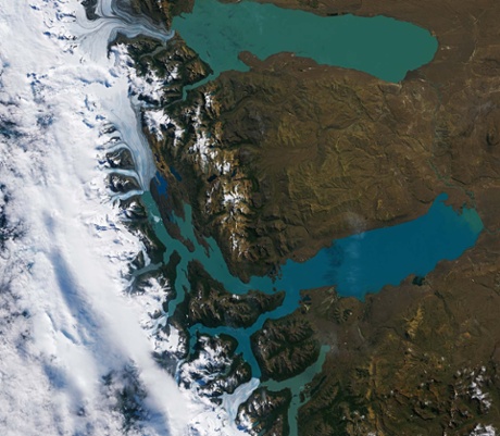
Part of the Southern Patagonian Ice Field – the world’s second largest contiguous extrapolar ice field – and two lakes seen here in this image of Argentina’s Los Glaciares national park, which was named a Unesco world heritage site in 1981. It is situated in the area around Lake Viedma (top of image) and the country’s largest freshwater Lake Argentino (below). Both are fed by water from melting glaciers and by rivers and their unique colour is attributed to ‘glacier milk’: suspended fine sediment produced by the abrasion of glaciers rubbing against rock. The majority of the nearly 50 big glaciers fed by the Patagonian Ice Field in the park have been retreating during the past 50 years because of warming temperatures.
Taal volcano is complex. Instead of rising from the ground as a distinct, singular dome like its neighbour, Mayon, Taal consists of multiple stratovolcanoes, conical hills, and craters of all shapes and sizes. These features have grown together to form the three-mile wide Volcano Island, one of the Philippines’ most volcanically active areas. The island rises from the north-central side of Taal lake, which in turn fills the much broader Taal caldera.
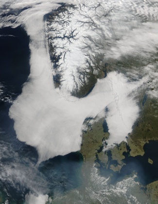
Low clouds hang over the North Sea, Skagerrak and Kattegat. The huge fog bank wraps around the southern tip of Norway and the northern tip of Denmark, on the Jutland peninsula. It also reaches across southwestern Sweden and hides Vänern, the largest lake in Sweden, from view. The bank stretches hundreds of kilometers from the North Sea, to the west of Norway, over Skagerrak and Kattegat. Skagerrak is the strait running between the southeastern coast of Norway and the Jutland peninsula. The Kattegat is the sea area between the Jutland peninsula in the west and Sweden in the east.
Spring is changing the landscape of the northeastern United States, as the warming temperatures and lengthening sunlight begin to melt winter’s heavy blanket of snow. However, snow remains in southeastern Canada, as well as in Maine, the most north-eastern US state. It also clings to the higher elevations in New Hampshire, Vermont, and New York, and parts of Massachusetts. Further south, the land snow-free. The ice cover on the Great Lakes is greatly diminished, and the finger lakes of New York are ice-free.
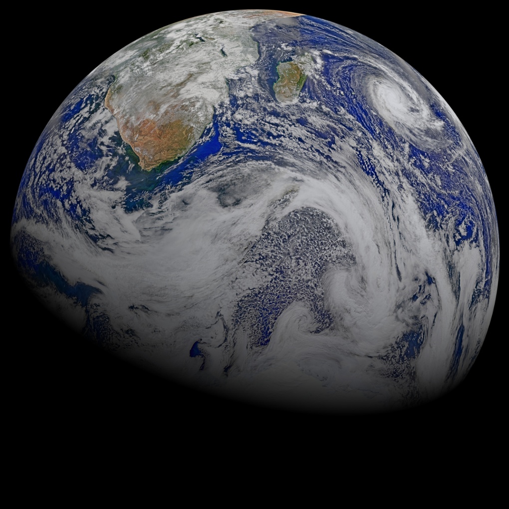
Forty-five years ago this week, Americans celebrated the first Earth Day, 16 years ago, on 29 April, the Nasa Earth Observatory was launched on the world wide web. Both the holiday and the website celebrate awareness of our planet, its power, and its fragility. The above composite image captures some of that beauty.
Most of the scene is filled by the Indian Ocean (center and left), while parcels of the Atlantic (top left) and Southern Ocean (bottom) fill in the rest. The image also includes southern Africa and Madagascar, with tropical cyclone Joalane swirling in the Indian Ocean.