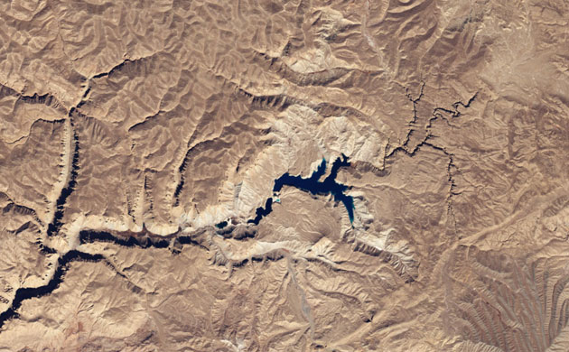
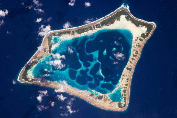
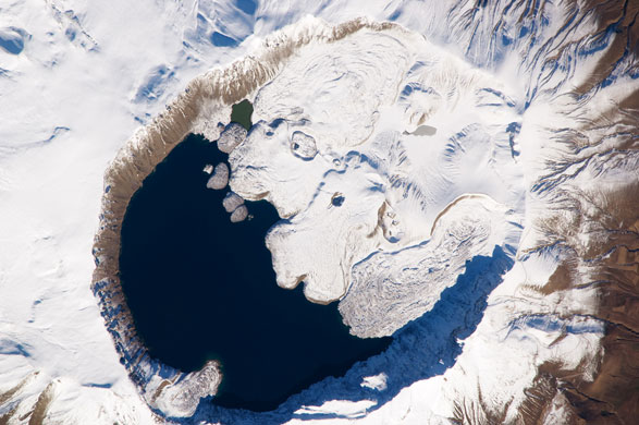
This Envisat image over the North Sea captures numerous aircraft condensation trails, or 'contrails', as well as parts of the Netherlands (upper right), Belgium (lower right) and England (lower left)Photograph: ESAAfghanistan established its first national park in April to protect Band-e-Amir, a chain of six intensely blue lakes created by natural dams high in the mountainous desert of the Hindu Kush. The lakes formed from mineral-rich water that seeped out of faults and cracks. Over time, the water deposited layers of hardened mineral (travertine) that built up into walls that now contain the waterPhotograph: NASAAt roughly 8km wide, Atafu atoll is the smallest of three atolls comprising the Tokelau Islands in the southern Pacific. The islands - just 2m above the tidal high-water level - suffered significant inundation and erosion during Cyclone Percy in 2005. Vulnerability to tropical cyclones and potential sea level rise make the long-term habitability of the atoll uncertainPhotograph: NASA
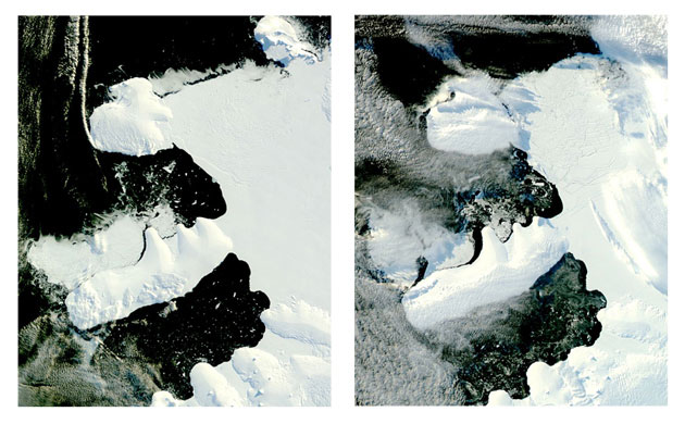
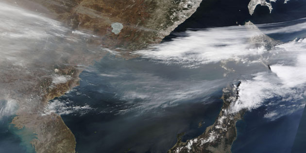
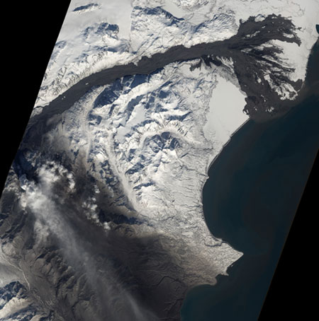
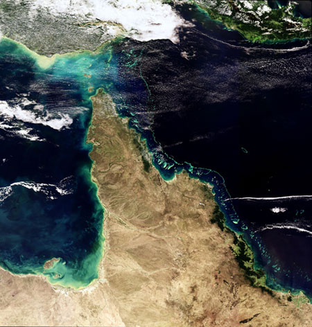
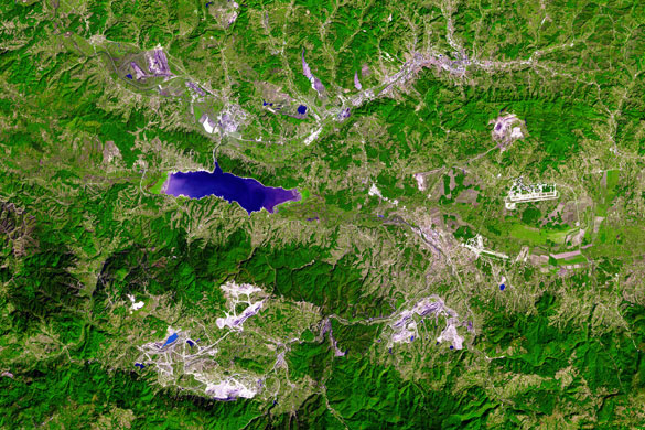
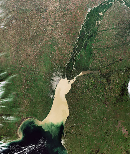
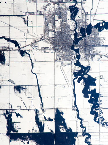
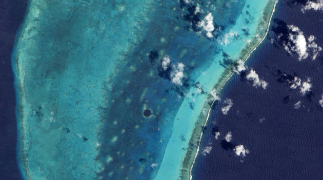
These photo-like images show the break-up of a narrow ice bridge connecting Charcot Island and Latady Island - the last remnant of the northern part of Antarctica’s Wilkins ice shelf that broke apart in early AprilPhotograph: NASAA thick band of haze blew over the Sea of Japan during April, appearing as a translucent band of dingy gray. Over northern Japan, the haze blends with opaque white cloudsPhotograph: NASAThis detailed astronaut photograph focuses on the summit caldera of Mount Nemrut (Nemrut Dagi in Turkish), a stratovolcano in the eastern Anatolia region of Turkey, along the shoreline of Lake Van. Winter snow blankets the 2,948m (9,672ft) summit of the mountain, highlighting the brown caldera rim. The snow also highlights the irregular shape and wrinkled surfaces of several lava flows present in the eastern portion of the caldera. A cold-water caldera lake occupies the western half of the summitPhotograph: NASABesides volcanic ash, the eruption of Alaska's Mount Redoubt posed another hazard in early April 2009 as muddy volcanic avalanches swept through Drift River valleyPhotograph: NASAThis image features one of the natural wonders of the world, the Great Barrier Reef, off the east coast of Queensland, Australia. Australian researchers have discovered that Envisat's Medium Resolution Imaging Spectrometer (MERIS) sensor can detect coral bleaching down to 10m deep. This means Envisat could potentially map coral bleaching on a global scalePhotograph: ESAThe Tuzla Basin in north-eastern Bosnia and Herzegovina has been an industrial mainstay in Eastern Europe since the late 1800s. The area is among the largest suppliers of lignite (brown coal) and coke-production plant in the town of Lukavac. In this image, vegetation is green (brighter than it would naturally appear), bare or urbanised land is light purple to grey, and water is purplish-blue. Several large mines and their associated debris are scattered across the image. Four large open pit mines appear in a clockwise arrangement starting south-east of Tuzla: Dubrave, Djurdjevik, Mrdici and Banovici, all of which produce brown coal. At the upper left corner of the image is the Kreka strip mine, which produces lignite. East of the inactive Ontario Strip Mine, lavender-coloured patches are fly-ash deposits, the residue left over from coal burning at the Tuzla power plantPhotograph: NASAThis image shows Buenos Aires, the coastal capital of Argentina. Home to 12m people, the large conurbation of Buenos Aires is seen as a distinct grey area on the southern bank of the River Plate, with the smaller purpose-built provincial capital of La Plata just to its east. The Uruguayan capital of Montevideo is another smaller grey mass on the north side, on the mouth of the River PlatePhotograph: ESAThis Envisat image captures cloud over the northern part of the Scandinavian peninsula, shared by Norway (left and top), Sweden (left of the Gulf of Bothnia seen at bottom centre) and Finland (right of the gulf). The Russian Federation is visible along the right-hand side of the image. Cloud streets are parallel rows of clouds that align with the wind and have formed over the Barents Sea due to the mixture of heat, moisture and wind. In this image, cold, dry air masses over the ice are flowing from the north to the southPhotograph: ESAWhen this astronaut photo was captured on April 9, the Red River was experiencing its second round of spring flooding. The Red River flows north between North Dakota and Minnesota from the confluence of the Bois de Sioux River (south, image lower right) and the less well-drained, meandering Otter Tail River (east, image right). Floodwaters in these two tributaries appear as black shapes against a snowy agricultural landscape that is defined by rectangular fieldsPhotograph: NASAThis radar image shows Vietnam's Mekong Delta where the Mekong, the world's 12th longest river, fans out into tributaries and empties into the South China Sea. Ho Chi Minh (formerly known as Saigon), Vietnam's largest city and chief port, is visible as white in the upper right corner Photograph: ESATo expand the possibilities for beachfront tourist development, Dubai undertook a massive engineering project to create hundreds of artificial islands along its Persian Gulf coastline. Built from sand dredged from the sea floor and protected from erosion by rock breakwaters, the islands were shaped into recognisable forms, including two large palm trees, and even more ambitiously, a map of the world. A breakwater surrounds the archipelago, and its role is obvious: outside the perimeter, especially to the north-west, the waters of the Gulf ripple with waves that would wear the artificial islands awayPhotograph: NASASurrounded by darker, deeper ocean waters, coral atolls often glow in vibrant hues of turquoise, teal, peacock blue, or aquamarine. Belize's Lighthouse reef atoll fits this description, with its shallow waters covering light-coloured coral: the combination of water and pale corals creates varying shades of blue-green. Within this small sea of light colours, however, lies a giant circle of deep blue. Roughly 300m (1,000ft) across and 125m (400ft) deep, the feature is known as the Great Blue Hole and appears at the centre of the image, surrounded by a ring of lighter colour caused by elevated coral. In fact, parts of the ring surrounding this feature actually crest the water surface at low tidePhotograph: NASA
Sign up to read this article
Read news from 100’s of titles, curated specifically for you.


.png?w=600)