Any walk that follows the top of a scarp is good, but the section of the Cotswold Way overlooking Cheltenham has to be one of the best, with open views and a limestone upland nature reserve.
Start & finish: Car park by the radio masts (grid ref SO993248)
Length: 5 miles
Highlight: Panoramic views
Best pub: The Rising Sun Hotel on the B4632, with a big garden and views across the Severn Vale
The walk
From the car park, turn left and follow the fence and newly restored drystone wall, picking up the Cotswold Way as it joins from the west (1.4 miles). If you like, detour slightly east to the solitary tree at the high point on Cleeve Common, which peaks nearby at a modest 330m (although locals say it's the highest point between here and the Urals). The common was the old site for the racecourse, until it was moved downhill into genteel Cheltenham.
Zigag round the edge of the escarpment (2.3 miles), pausing for the vista. Usually you can see the stately tower of Gloucester Cathedral, and on good days the Black Mountains in Wales.
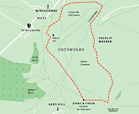
From the golf course (stop at the clubhouse for refreshments), keep following the Cotswold Way, but when the path splits at the second gate, bear right (3.3 miles). The grassy track widens, follow it as it bears left. At the white post (near the source of the Isbourne), follow the path round the south of the common (a great place for flying kites) and back to the car park. If you didn't stop at the clubhouse, head to the Rising Sun for more great views.