LOS ANGELES _ Officials on Thursday released new draft maps showing the locations of earthquake faults in Santa Monica, Beverly Hills and Los Angeles' Westside, raising the prospect of development restrictions in areas directly above the fissures.
The earthquake faults run along some of Southern California's most expensive real estate, covering such neighborhoods as Brentwood and Pacific Palisades as well as Century City, Westwood and other premium business centers.
The long-awaited maps _ which include new boundaries for the Santa Monica, Hollywood and Newport-Inglewood faults _ are part of an effort by the state to locate fault lines so that new buildings are not constructed on top of them.
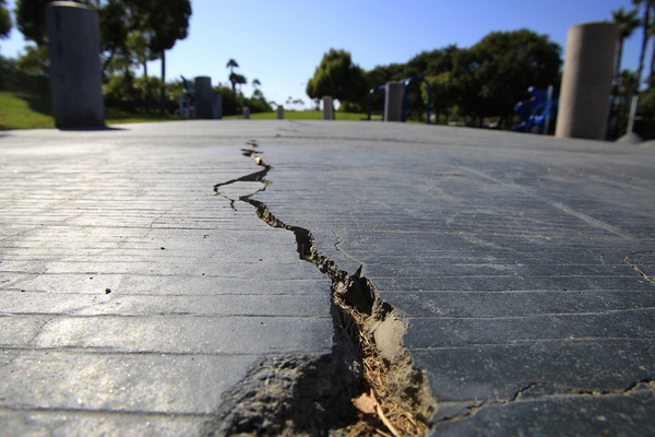
"It is important to not build on faults," said Tim Dawson, senior engineering geologist for the California Geological Survey. "Building foundations will tend to break when the earth moves beneath them, damaging the building in the process."
If the ground moves dramatically as a fault breaks the land, a building could completely collapse, Dawson said.
The release of the maps marks the first time the California Geological Survey has issued official draft maps for earthquake faults on the Westside. The new maps complete the western edge of the Hollywood fault, which runs through West Hollywood and Beverly Hills, and the northern edge of the Newport-Inglewood fault, which runs through Culver City, Pico-Robertson and Mid-City.
A Los Angeles Times analysis in 2013 showed that more than a dozen projects _ including apartments and offices _ were approved along the path of the Santa Monica and Hollywood faults in the last decade without requiring seismic studies, according to public records.
Such studies would have been required had the state completed the fault mapping. From 1991 to 2013, budget cuts dramatically reduced the state's pace of mapping faults.
The maps could have implications for future development on the Westside. As the state drew maps for the Hollywood fault several years ago, it intensified debate over a plan to build Hollywood's tallest skyscrapers above what state officials said was an active fault.
The state's actions do not affect existing buildings, though structures on and close to faults have a high risk of major damage. The Times found that there are roughly 1,400 buildings on or next to the Santa Monica and Hollywood faults, based on maps available in 2013.
The increased state mapping of faults comes as local governments are trying to improve seismic safety measures. Three cities along the Santa Monica and Hollywood faults _ Los Angeles, West Hollywood and Santa Monica _ have passed laws requiring property owners to retrofit certain types of buildings at high risk of collapse in major earthquakes.
State lawmakers banned new construction directly on top of faults in official earthquake zones after the 1971 Sylmar earthquake, which ripped apart many homes directly on top of the San Fernando fault, as land on one side of the fault slid past the other. In one neighborhood alone, 80 percent of homes near the fault suffered moderate to significant damage.
At one home, the earthquake fault's movement warped the land underneath it. A photo taken by a state official in 1971 showed the fault's movement dislodging the side wall of a garage, and the street bending slightly into the shape of the letter U.
"Prior to the earthquake, the street and lawn (were) originally flat," Dawson said.
Once the maps are finalized, state law will require that anyone seeking to build in a fault zone be required to hire a geologist to investigate whether construction will be on an actual fault line. Local building officials will have the final authority to ensure new structures are built away from faults.
"Extra precautions should be taken to ensure new buildings are not located on the trace of an active fault," Dawson said. "The purpose of the investigation is to identify if there are active faults present, and if there are, then they must be avoided."
The maps are subject to revisions as the California Geological Survey seeks public feedback. Comments are due to the State Mining and Geology Board by Oct. 11.
State officials also released updated fault maps for areas struck by the magnitude 6 Napa earthquake in 2014.
That earthquake revealed previously undiscovered faults that ran through residential homes, destroying the foundations of some.
The pace of earthquake map drawing accelerated after Gov. Jerry Brown in 2014 proposed an increase in the state budget to map faults in California.