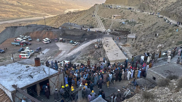
Landslips have become a regular threat after floods of 2018, with 4,728 major and minor ones that year killing 48 people.
Devastating landslips also occurred in 2019, 2020, and 2021, killing 163 people and inflicting irreparable damage to property, houses, roads and bridges.
According to the landslip susceptibility zones of districts of Kerala, prepared by the Geological Survey of India (GSI), around 14.4% of land spread across 13 districts is in landslip susceptible zones, the map of which is expected to be released in June.
C. Muraleedharan, chairman of the advisory committee for landslips and risk reduction under the KSDMA and former Deputy Director General of the GSI, says as much as 15,000 sq km in 13 districts is prone to landslips. As per the landslip susceptibility map of Kerala, around 3,300 sq km is highly susceptible to landslips while the threat is moderate in another 2,886 sq km.
Landslips are primarily triggered by high-intensity rainfall over a small area which has become a regular phenomenon. But there are man-made factors too. The southwest and northeast monsoons for a period of six months starting from June to November is a major cause for concern as continuous heavy rainfall over loose scree material in vulnerable hilly terrains can lead to landslips, he says.
A KSDMA study, after the massive landslips in Idukki and Kottayam in 2021, found that all the landslips in Kerala after the 2018 floods had been triggered by sporadic high intensity rainfall in a single day. The rainfall saturates the soil column and the subsequent anomalous high-intensity precipitation is sufficient enough to trigger landslips in the highlands.
The three major landslips in 2021 in the same valley were triggered by high intensity rainfall of 266 mm in a day, the study says.
Landslips are also caused by human interventions such as replacing natural vegetation with (mostly monoculture) plantations, road constructions, and human settlements in vulnerable hilly areas.
“The erratic rain pattern underlines the fact that there will be more landslips in every monsoon in Kerala. So, the key to reducing the risk of rainfall-induced landslips is an accurate and precise rainfall forecast, which will help in issuing early warning based on the rainfall threshold of an area,” says a scientist attached to the Landslide Studies Division of the GSI.
Installing automated rain gauges that report rain information near real-time will be crucial to creating early warning systems.
“Though the State had requested 100 automatic weather stations, the IMD has installed 35 AWS so far and work on the remaining is under way. Deforestation, unregulated mining, and unscientific land use planning have all exacerbated the problem of landslips. Heeding alerts and shifting to safer locations during critical time is the best way to avoid an unpleasant situation along with raising the technical capability to issue early warnings, “says Mr Muraleedharan.