An extreme weather pattern is affecting conditions across the U.S. and Europe, specifically a powerful area of high pressure across Greenland and Hudson Bay. This feature, known as a “Greenland Block,” along with another weather cycle, typically lead to cold and snow in the eastern U.S., parts of Europe and Asia.
The big picture: The blocking high over Greenland is acting like an atmospheric detour, diverting weather systems around it and favoring, but not guaranteeing, cold air outbreaks in Europe and North America as Christmas approaches.
- In the U.K., temperatures plunged below freezing in many areas Wednesday with unusually cold conditions predicted to last into the weekend and next week.
- The U.K. Met Office is predicting snow, ice and in some locations, blizzard conditions, for parts of Scotland, Ireland and Wales.
- This could cause energy prices to steeply rise after winter got off to a mild start, given tight gas supplies because of the war in Ukraine.
Meanwhile in the Arctic, temperatures have been running much milder than average despite 24 hours of darkness.
- On Sunday, Utqiagvik, the northernmost community in the U.S., saw its warmest day ever in December, with a high of 40°F. This was also the warmest day there between Oct. 20 and April 22, per the National Weather Service.
- Greenland, which sits under the dome of high pressure, has also seen unusually mild conditions recently. Due mainly to human-caused climate change, the Arctic has been warming at about four times the rate of the rest of the globe.
Between the lines: Meanwhile, conditions over the North Atlantic are reminiscent of the blizzard-inducing setup during the winter of 2009-10, when the “Snowmageddon” and “Snowpocalypse” blizzards buried the Mid-Atlantic states.
- However, there is no guarantee this pattern will have the same result, experts told Axios. In fact, signals so far indicate that it could even lead to milder-than-average conditions in the Central and eastern U.S. for the next week or two.
- The North Atlantic Oscillation, which is the cycle of air pressure variability over the central North Atlantic Ocean, also currently favors cold air outbreaks and snow for parts of North America, Europe and Asia. The NAO index is calculated by taking the difference in sea level air pressure between Iceland and the Azores.
- The last time the NAO was this negative during the month of December was in 2009, according to Judah Cohen, head of seasonal forecasting at AER.
- Cohen told Axios the NAO is a big driver of colder-than-average conditions in Europe, and often does the same for the eastern U.S.
- Some of the biggest snowstorms in cities like Washington, New York and Boston were tied to negative phases of the NAO.
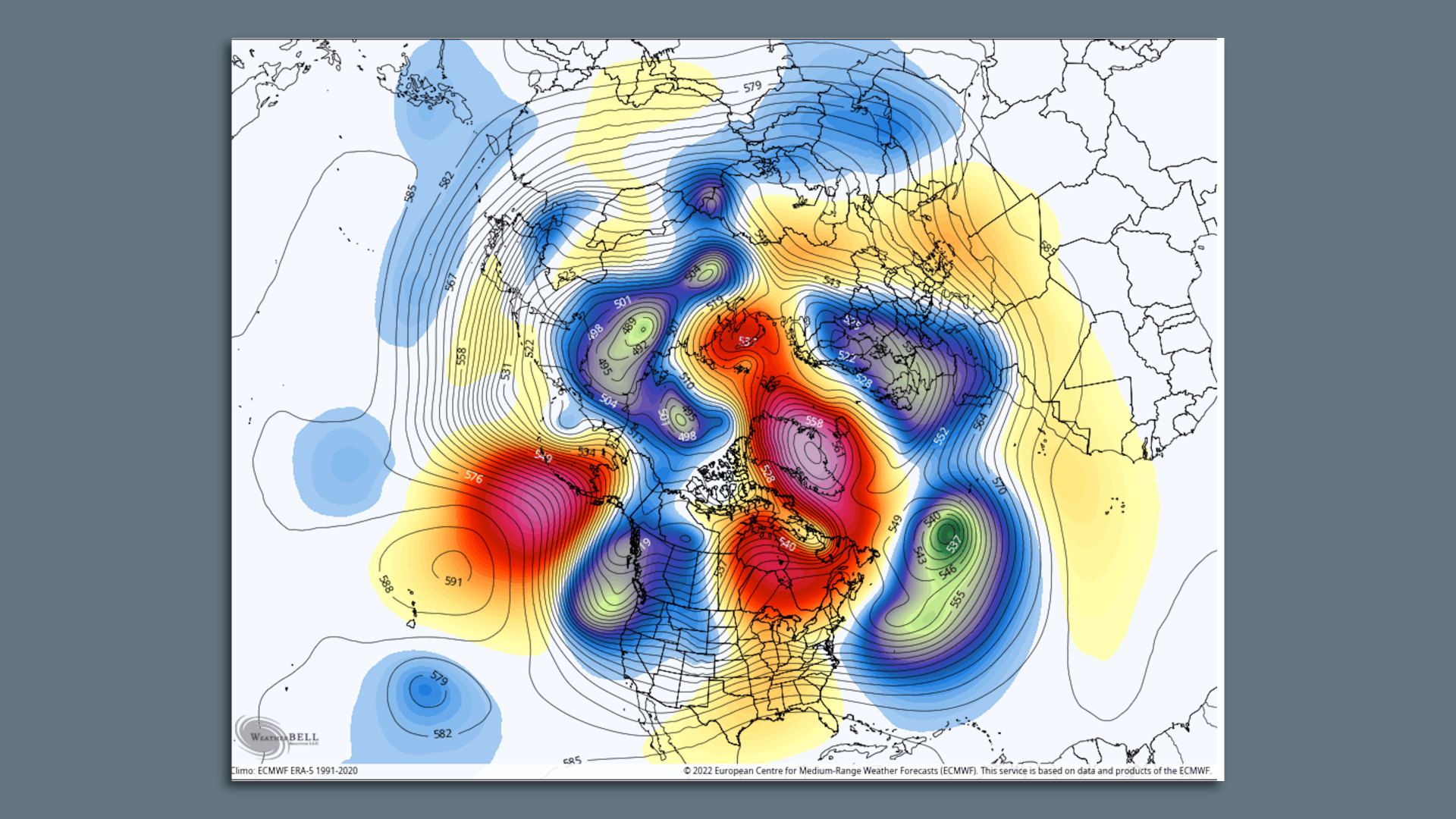
How it works: During periods with Greenland blocking and negative NAO conditions, the jet stream blowing from west to east across the U.S. is often forced to the south, preventing storms from moving to the west of the I-95 corridor and bringing mild air and rain.
- Instead, these factors raise the odds of colder, coastal storm tracks that tend to have higher odds of being prolific snow producers.
- “I think that there is a very good chance this pattern will eventually produce something memorable,” Cohen said, noting that computer model projections don’t yet show such a scenario.
The intrigue: According to University of Oklahoma meteorologist Tomer Burg, subtle differences between the current weather pattern and past Greenland blocking events may make all the difference in this case.
- Instead of blocking allowing for frigid air to invade Europe and the U.S. right away, computer models are showing the likely development of a powerful storm system in the Central U.S., with the potential for severe thunderstorms in the South, and heavy snow in the Plains and Rockies.
- Meanwhile, the East could see a period of unusual warmth. This storm could, over time, allow cold air to work its way east by the end of the month.
The bottom line: Extreme weather patterns often result in notable outcomes, even if they don't conform to the textbook definition of a particular phenomenon.