The eastern US remained in the grip of fierce cold on Saturday, as forecasters warned of yet another winter storm amid the ongoing effects of the polar vortex and the almost equally sinisterly named “Siberian Express”. The extreme cold, which has set records and even frozen over Niagara Falls, is expected to last into next week.
More snow and freezing rain was forecast for Boston and other parts of New England, one of the regions heaviest-hit so far.
“Arctic air from the Siberian Express – an air mass that originated near Siberia in the Arctic region – remains over the eastern half of the country,” a National Weather Service (NWS) advisory said, while warning of a “widespread snow and ice event”.
Bruce Sullivan, a senior meteorologist with the NWS, confirmed that the US had indeed been hit in one week by both the polar vortex – a pocket of very cold air that usually swirls around the North Pole and which made headlines when it hit the country last year – and the Siberian Express.
For the weekend, Sullivan forecast “higher amounts” of snow for Ohio and western Pennsylvania. “That’s where it looks like the jackpot will be,” he said.
The Weather Channel – which named the storm “Pandora”, indicating its severity as storms deemed less serious by the channel’s panel of scientists are not given names – said it would “impact parts of the south, midwest and north-east with snow and ice” and would also bring snow to the Rocky mountains.
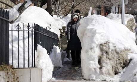
The adverse effects of the weather have been widespread. Boston is still digging out from heavy snowfall which has left its transit system in chaos and some residents questioning why the city has not attracted sympathy and material support from the rest of the country.
Boston is having its second-snowiest winter on record, and at an unprecedented intensity. Nearly 100in has fallen since 23 January, a few inches shy of the all-time record and in a much shorter time. At one point, 5ft fell in just over a week.
On Friday, a passenger ferry became stuck in ice in the city’s harbour, and had to be towed to safety by an ice-breaker. Tempers were not helped by an admission from city authorities that a clerical error had wiped from the records 9,000 requests for aid in clearing snow and ice.
“It was a mistake,” Mayor Marty Walsh told the Boston Globe. “A staffer – I’m not sure who it was – automatically just closed all these cases with the anticipation of a new storm coming. They shouldn’t have done it.”
Walsh was also forced to request this week that people cease the practice of “snow jumping” – propelling themselves from heights, often upstairs windows, into massive banks of snow while wearing only bathing costumes.
Much of New England is also having a punishing winter of epic and ruinous proportion. On the scenic Cape Cod island of Nantucket, hurricane-force winds and an ice storm blacked out power for more than 12,000 people for several days, after transformer boxes in a substation became coated with ice.
Charlie Baker, the governor of Massachusetts, issued a state of emergency for the entire state on 9 February – it remains in effect. A review in the Boston Globe on Friday found that the snow had claimed “at least nine lives”, including two people who were struck by snowplows.
Three to five inches of snow were possible for New England on Saturday, followed by freezing rain, prompting warnings over the increased weight of uncleared snow and ice on roofs. More than 100 buildings have collapsed so far.
The cold has also affected many southern states, which are not as prepared for cold weather as New England. By Friday, 11 people had been reported dead from effects of the cold in Tennessee.
On Friday night and into Saturday morning, Alabama was hit by ice, sleet and snow. Schools closed early, as they have done in many southern states throughout the week, and forecasters said the north-eastern corner of the state and neighbouring Georgia would suffer into Saturday. Kentucky and West Virginia were also hit.
In Virginia, the national guard flew food, medicine and mail to Tangier Island, which has become ice-locked in the middle of Chesapeake Bay. In New York City, the Hudson and East Rivers were partly frozen.
Record low temperatures were set around the country on Friday. The NWS said Washington DC’s Reagan National Airport hit 6F (-14C) while Baltimore’s airport recorded a record February low of 2F (-17C). In New Castle, Pennsylvania, the low was an astonishing -18F (-28C); New York City returned a record monthly low for Central Park, of 2F.