Rain will close out the week for Canberra, with heavy downpours expected to extend into Friday.
The Bureau of Meteorology on Thursday warned that heavy rain could lead to flash flooding, with up to 40mm expected.
The ACT could see between 25 and 45mm on Friday, with the BOM advising heavy falls are likely.
Thunderstorms are possible across both days, with showers rolling into the weekend but some relief as the heavy downpour lets up.
ACT Emergency Services Agency said they had not yet responded to any weather-related incidents on Thursday morning.
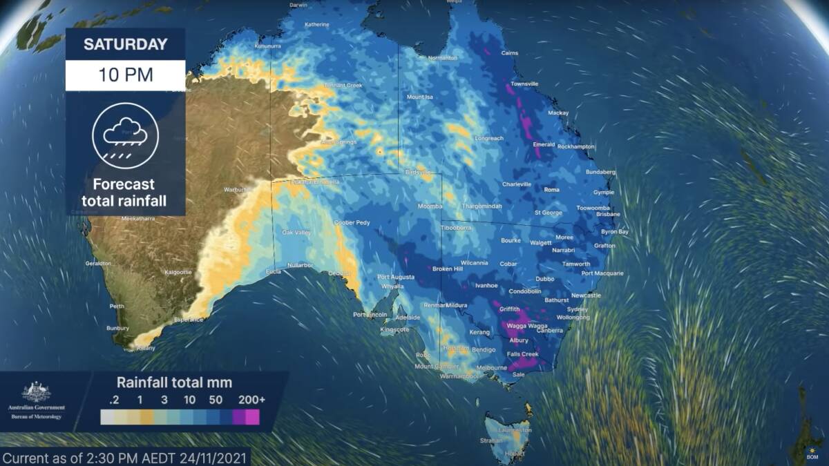
Australians along the eastern seaboard are bracing for a "peak day of rainfall" today with totals of 25 to 100mm anticipated for NSW, Queensland, the ACT and eastern Victoria.
Bureau of Meteorology meteorologist Jackson Browne said a low pressure system over eastern South Australia was moving east towards the east coast in a severe weather update.
"Accumulated rainfall shows our cloud band shifting over the eastern two thirds of Australia with Thursday being the peak day of rainfall. Widespread falls of 25 to 100mm with higher amounts and thunderstorms are likely," Mr Browne said.
"The track of this low pressure system will dictate exactly where the strongest rainfall will be. Widespread rainfall should extend along the east coast of Australia on Friday with conditions beginning to fine up, at least for most of NSW and Victoria, by Saturday."
Severe weather warnings for heavy rainfall have been issued across multiple states and "further warnings are likely".
"Severe thunderstorm warnings may be issued as needed, carrying the risk of damaging winds and heavy rainfall," Mr Browne said.
There are also a number of flood warnings across NSW, Queensland, Victoria, South Australia and the ACT.
"Flood warnings are current over multiple river catchments with some exceeding the major flood level in NSW and Queensland. Dams are full and many catchments are either flooded or saturated so any further rain or thunderstorm activity this weekend will need to renewed river level rises across many rivers and creeks," Mr Browne said.
"Flood watches have also been issued in anticipation of the upcoming rainfall. Residents living on and near flooded rivers and creeks, especially in parts of NSW, Queensland and eastern Victoria, need to stay alert to the latest forecasts and warnings as many rivers are likely to experience flooding in the coming days."
A Severe Thunderstorm Warning has been issued for parts of the Southern Tablelands and South Coast districts. Check details at https://t.co/GK3ZIEsivYpic.twitter.com/RDW3arXsus
— Bureau of Meteorology Australian Capital Territory (@BOM_ACT) November 25, 2021
Visit the BOM website to see the latest severe weather and flood warnings for your local area.
Floods have been so bad that teachers were dropped off at school in a helicopter in Forbes in Central West NSW on Monday.
Students near the Central West NSW town of Forbes have witness a school drop-off like no other this week after RFS helicopters transported their teachers across floodwaters to their school gates.
In order to attend classes at Bedgerabong Public School on Monday, three teachers had to cross the dangerously high floodwaters.
So, to avoid cancelling classtime, the teachers were given the aid of the helicopters, which dropped them off at their school oval.
The town remains on flood alert as the Lachlan River continues to overflow, blocking streets and major arterial roads.