- LAST UPDATED SUNDAY 8.30AM
RESIDENTS along the Paterson and Williams river are on alert with moderate to major flooding expected on Sunday.
According to the most-recent information released by NSW SES, river levels at Gostwyck Bridge remain at major flooding, Mill Dam Falls is experiencing moderate flooding and at Dungog there is minor flooding.
Further rainfall is expected over Sunday and into next week, which may cause further river rises.
Williams River:
Moderate flooding is occurring along the Williams River at Mill Dam Falls and minor flooding is occurring at Dungog.
The Williams River at Dungog is currently at 5.35 metres and falling with minor flooding.
The Williams River at Mill Dam Falls is currently at 8.01 metres and falling with moderate flooding.
Paterson River:
Major flooding is occurring along the Paterson River.
The Paterson River at Gostwyck Bridge is currently at 12.49 metres and falling with major flooding
What we are expecting:
At Dungog and surrounding areas:
- Low lying farm land inundated.
- Forsterton Road closed at Forsterton Bridge
- Alison Road (southern end) closed at the Thalaba Bridge
- Glen Williams to Dungog Road may close at the Banfield Bridge, Glen William.
- Possible isolation of Bendolba and Bandon Grove
- Residents and business may experience flooding in Hook and Dowling Streets
- Possible isolation of Alison Road
- Dungog to Stroud Road may close west of Coorel Bridge
- Dowling Street all properties between Hooke Street intersection and Alison Road intersection may become flooded
- Possible over floor flooding of low lying properties in Dowling, Hooke Brown, Ablalard, Myles, Lord, Hillview, Windeyer, Baird, Burton Streets
- Possible inundation off all of Alison Court Retirement Village closure of Union Bridge may cause the isolation of Dungog
At Mill Dam Falls and surrounding areas:
- Low lying rural properties and roads may be affected by flood waters
- Possible inundation of low lying areas of Williams River Caravan Park
- Properties along east Seaham Road and near Middle Crescent Street need to closely monitor river heights
- Flooding may affect low lying areas of Clarence Town including King, Grey, Durham, Russell Streets
At Gostwyk Bridge and surrounding areas:
- Low lying rural properties and roads may be affected
- Low level causeway at Horne's Crossing over the Allyn River maybe closed
- Scotts Dam Road, Paterson-Woodville Road at Dunns Creek and Iona, Woodville -Seaham road at Taylor Bridge may close
At Paterson and surrounding areas:
- Low lying rural properties and roads may be affected by flood waters
- Tocal Road may be affected by floodwater at various locations including Tucker Park and Clements Bridge
- Maitland Road may close at Swamp Hollow
- Water may start to flow from the Hunter River into Hinton - this may cause local road closures
- Spillways downstream of Dunmore Bridge to Hinton may overtop - this has the potential to isolate Hinton Possible start of inundation into Phoenix Park
- Possible closure of Scotts Dam Road and Paterson Woodville Road at Dunns Creek, Woodville to Seaham Road at Taylor Bridge
- Possible isolation of Paterson due to road closures
- Possible isolation of Bellevue Estate due to road closures
- At Hinton flood waters may start to impact low lying roads and bridges.
What residents need to do:
People in areas likely to be impacted by flooding in low lying areas of Clarence Town should prepare for possible evacuation and inundation of low lying properties.
Do not drive, ride or walk through flood water
Farmers on low lying land close to rivers and creeks are urged to monitor livestock, pumps and other equipment. Waste and chemical containers should be located well above predicted flood levels.
Residents of low lying areas near the river should keep an active watch on the flood waters.
Keep in contact with your neighbours.
Consider impacts of possible road closures on work, family and educational commitments.
Monitoring emergency warnings and severe weather updates on local ABC radio, NSW SES Hunter Facebook Page and Bureau of Meteorology website.
If you live in a low-lying area and are advised by an emergency services officer to evacuate, please do so.
For emergency help in floods and storms, call the NSW State Emergency Service on 132 500. In life threatening situations call triple zero (000) immediately.
Latest River Heights for the Williams River:
Location Height of River (m) Tendency Date/Time of Observation
Williams River at Dungog 5.35 Falling 12:45 AM SUN 21/03/21
Williams River at Mill Dam Falls 8.01 Falling 01:00 AM SUN 21/03/21
Allyn River at Halton 2.15 Falling 12:00 AM SUN 21/03/21
Paterson River at Gostwyck Bridge
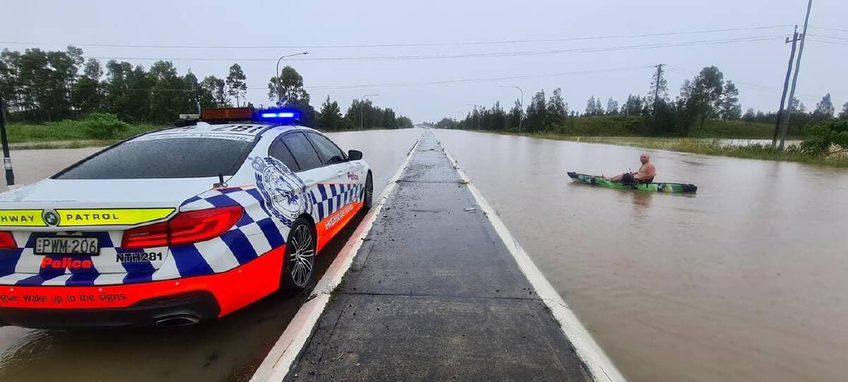
Here are the latest road closures due to the current weather event. Emergency services have advised Hunter residents to delay all non-essential travel. A severe weather warning remains in place for the region.
BOM Flood Safety Advice:
In life threatening emergencies, call 000 (triple zero) immediately. If you require rescue, assistance to evacuate or other emergency help, ring NSW SES on 132 500.
- Avoid drowning. Stay out of rising water, seek refuge in the highest available place.
- Prevent damage to your vehicle. Move it under cover, away from areas likely to flood.
- Avoid being swept away. Stay out of fast-flowing creeks and storm drains.
- Never drive, ride or walk through flood water. Flood water can be deceptive and dangerous.
For more emergency information, advice, and access to the latest river heights and rainfall observations and forecasts:
- NSW SES: www.ses.nsw.gov.au
- AUSGRID Emergency phone line: 13 13 88.
- RMS Live Traffic: www.livetraffic.com
- Latest River Heights and Rainfall Observations: www.bom.gov.au/nsw/flood/midnorth.shtml
- Latest NSW Warnings: www.bom.gov.au/nsw/warnings/
- Rainfall Forecasts: www.bom.gov.au/australia/meteye/
- BOM NSW Twitter: www.twitter.com/BOM_NSW

.png?w=600)