Summary: communities in NSW and Queensland remain under threat
NSW
About 2,000 firefighters are currently fighting more 108 active bushfires in NSW.
Up to 20 building, including homes, are believed to have been destroyed when firefighters lost control of a backburn at the Gospers Mountain fire, northwest of Sdyney.
Emergency warnings remain in place for the 396,000 hectare Gospers Mountain fire, which is burning in the Wollemi National Park.
The fire is burning on multiple fronts. Warnings were issued to 24 communities and localities and six more have already been burned through. It’s now burning on boths ides of Bells Line Road.
Residents in Wallerawang, Lidsdale, and Blackmans Flat were told on Monday evening to seek shelter as the fire approached because it was too late to leave. Greenpeace has warned that Blackmans Flat was “immediately adjacent” to the Mount Piper Power Station, which has coal stockpiled.
About 450 houses in the upper Blue Mountains were without power on Monday because of the bushfires.
An emergency warning also remains in place for Palmers Oaky, near Lithgow, where a fire is burning west of the Castlereagh Highway. It’s about 40km west of the Gospers Mountain fire.
The Kerry Ridge fire, a 52,000 hectare fire in the Wollemi National Park, Putty State Forest and Coricudgy state forest, is burning toward Nullo Mountain and Bogee. Those areas have also been placed under an emergency warning. It could merge with the 23,000 hectare Paddock Run fire, the RFS warned.
Statewide, 742 homes have been destroyed since the fire season began.
Western Australia
Authorities are expected to downgrade an emergency warning for a fire burning north of Yanchep. Authorities managed to prevent the 13,000 hectare fire from entering residential estates in the area and saved 6,000 homes. One home and a petrol station were lost.
Queensland
Residents in the small regional community of Mount Maria, 75km north of Bundaberg, were told to evacuate because of an out of control bushfire burning towards Lowmead.
An evacuation warning was also issued for a separate fire burning out of control near Gregory, south of Bundaberg.
Emergency warning for the Kerry Ridge fire, near Muswellbrook
The RFS have issued a new emergency warning for areas near Muswellbrook.
EMERGENCY WARNING - Kerry Ridge fire (Muswellbrook, Singleton and Mid-Western LGA)
— NSW RFS (@NSWRFS) December 16, 2019
Fire activity increasing. If you are in the area of Olinda, Nullo Mountain and Bogee, watch out for embers that may start fires ahead of the main fire front. #nswrfs #nswfires #alert pic.twitter.com/6UEV0imNRS
That brings the number of emergency warnings currently active in NSW to three.
Heat records across Australia could tumble this week, with forecast tops of 44C in Adelaide on Friday, 41C in Melbourne on Friday, and 43C in Canberra on Saturday.
Areas of inland South Australia are forecast to have five consecutive days of 45C or hotter, with three consecutive days of 47C and above.
There's a lot of red on the map. pic.twitter.com/egw0B6m7dt
— Calla Wahlquist (@callapilla) December 16, 2019
The SA heat record is 49.2C, which was recorded in Moomba in 1972. Temperatures are expected to reach those levels.
Bureau of Meteorology climatologist Dr Blair Trewin told AAP:
Australia’s warmest day on record occurred in January 2013, when the average maximum temperature across the continent was 40.3C.
We’re closely monitoring the development and progression of this heat but, based on current forecasts, we could see that record broken this week.”
Updated
At 6pm there are 2 fires at Emergency Warning and 3 fires at Watch & Act level. There are nearly 120 bush & grass fires burning across the state, & around 70 are not yet contained. Tomorrow Total Fire Bans are in place for Northern Slopes & North Western areas. #nswrfs #nswfires pic.twitter.com/qxBeQxT9AH
— NSW RFS (@NSWRFS) December 16, 2019
Emergency warning for Yanchep expected to be lifted soon
Fire authorities in Western Australia are hoping to downgrade the emergency warning for the bushfire burning near Yanchep later this afternoon, to allow residents to begin returning home.
John Newman, the incident controller of the Yanchep fire with the department of fire and emergency services, told ABC radio in Perth that he hoped that calmer weather conditions would mean that the warning level for Woodridge, Seatrees and Breakwater Estates could be lifted.
“As soon as we have confirmation that conditions are safe we will be looking at downgrading the alert levels,” he said.
“We are very keen to reduce (warning) levels there and get people back in.”
Newman said there was still an area of unburned bush heading toward Woodridge estate. If fire were to get into that bushland, he said, it “could well run into the community”.
The fire started on Wednesday and destroyed one home and a service station, as well as 13,000ha of bushland.
Newman said firefighters managed to save 6,000 homes.
“The fire started under very fire-favourable conditions and it was an excellent example for us of how quickly they can get up and how far they can run,” he said.
“I haven’t seen fire behaviour like this in early December at any time in my career.”
Updated
A bushfire near Collie, in south-west WA, has jumped containment lines.
A watch and act alert has been issued for surrounding residents. About 70 firefighters are currently trying to get the fire back behind containment lines.
Updated
Two schools in NSW will be closed tomorrow due to bushfires.
Bilpin public school, near Lithgow, will be closed due to the Gospers Mountain fire and Oakdale public school, on the eastern edge of the Blue Mountains, will also be closed.
The Bobin and Wytaliba public schools burned down last month.
Updated
The emergency warning remains in place for the Gospers Mountain fire.
Emergency Warning for Gospers Mountain fire. Fire activity & smoke increasing. People in Wallerawang, Lidsdale & Blackmans Flat area should seek shelter as fire approaches. #nswrfs #nswfires pic.twitter.com/ueYLY6rgGw
— NSW RFS (@NSWRFS) December 16, 2019
Updated
Craig Spencer from the Bindoon bushfire brigade in WA has described the search for a 12-year-old boy who drove the farm ute across paddocks to escape an out-of-control bushfire at Mogumber yesterday.
With the Help of DFES, Dalwallinu Officer S/C SMITH saved this 12 year old who was driving across paddocks to escape the fire 🔥 in Mogumber. He has been reunited with family and is safe and well #fb pic.twitter.com/zyrYCFgwSM
— Dalwallinu Police (@DalwallinuPol) December 15, 2019
The boy, named Lucas, was reported missing by his brother while the fire was under an emergency warning on Sunday afternoon. They began a search but could not find him. One hour later, Spencer said, Lucas pulled up alongside firefighters on the northern flank of the blaze, looking terrified and with his dog in the car.
Spencer told ABC24:
He had a manual Ford Ranger and he could probably drive it better than me, so that’s a good skill to have.
They gently prodded him to the passenger seat and drove the ute to the roadblock, where police took charge of him and helped him find his family.
We will get an update from the Western Australian fire and rescue service about the Yanchep, Two Rocks and Woodridge bushfire in about half an hour. There’s a press conference scheduled for 3.30pm local time in Gingin, an hour north of Perth.
Meanwhile, this is the Yanchep service station.
What once was the Yanchep Service Station #perthnews #yanchepservicestation @6PR pic.twitter.com/Ft2P164DDe
— Chelsie Stone (@stone_chelsie) December 16, 2019
And a note left behind in Two Rocks.
A sweet note left by a firefighter who defended a mans home in Two Rocks- he was forced to leave when embers started falling.@9NewsPerth @dfes_wa pic.twitter.com/UIYGt2KTtx
— Mia Egerton-Warburto (@MiaEgerton) December 16, 2019
Updated
There is an updated emergency warning for a 1,000ha bushfire burning out of control near Upper Turon Road, Palmers Oaky.
The fire is burning west of the Castlereagh Highway, north-east of Lithgow, on the other side of Bogee from the Gospers Mountain fire. Residents near Razorback Road, Cherry Tree Hill and Running Stream have been warned to be on the lookout for ember attacks.
EMERGENCY WARNING - Upper Turon Rd, Palmers Oaky (Lithgow LGA)
— NSW RFS (@NSWRFS) December 16, 2019
Fire W of Castlereagh Hwy, SE of Razorback Rd. If you're in Razorback Rd, Cherry Tree Hill & Running Stream, watch for embers that may start fires. Monitor conditions. #nswrfs #nswfires #alert pic.twitter.com/EjKxBtxdOX
Updated
A total fire ban has been issued for the Mount Lofty Ranges fire district of South Australia tomorrow.
That district includes Adelaide Hills, the Barossa Valley, Victor harbour, Mount Barker and Gawler. Temperatures are expected to be in the low-mid 4os for the next four days.
The fire danger rating for that region tomorrow is severe. The rest of the state has a rating of high or very high, apart from the upper south-east, where the danger rating is low to moderate.
Updated
An updated emergency warning has been issued for Mount Maria, north of Bundaberg in Queensland.
A large fire is burning west towards Lowmead, near Mount Maria. Areas around Tableland Road, between Cross Road and Hills Road, were being directly impacted by fire as of 3.40pm local time (4.40pm AEDT) and properties near Mitchell Road are expected to be impacted within the next hour.
Conditions are very dangerous and firefighters may be unable to prevent the fire advancing. It may pose a threat to all lives in its path. Residents have been advised to leave immediately as it will soon be too dangerous to drive.
There is an evacuation centre at Miriam Vale Community Hall.
Updated
There are currently 74 fires burning in New South Wales with emergency warnings active for the fire at Palmers Oaky, near Lithgow, and Gospers Mountain, where a huge 378,000ha fire is burning in the Wollemi national park.
There is also an emergency warning active for Woodridge, Seatrees and Breakwater Estates near Yanchep, north of Perth, in Western Australia.
Updated
The temperature in Brisbane reached 41.2C at 1.40pm. That’s equal to the city’s previous record for its hottest ever day, which was set in 1981.
As Australia looks to break record of 40.3C for highest ever national average temp across the country, #Qld has likely broken December records today with 43.2C at Gatton (beating 42.6C on 7 Dec 2019) and Brisbane hit 41.2C (equal highest w/ 1981). More ... https://t.co/aKNfS54zyk https://t.co/GShF8NZflw
— Bureau of Meteorology, Queensland (@BOM_Qld) December 16, 2019
Australia is on track to break its record for the highest ever national average temperature. The previous record is 40.3C.
Watch and act for Kumbarilla State Forest, Queensland
A watch and act warning has been issued for Kumbarilla State Forest, east of Brisbane, in Queensland.
Queensland Fire and Emergency Services says a fast-moving fire is continuing to burn in the Kumbarilla State Forest. It’s burning in a north-easterly direction toward the Moonie Highway between Halliford Rd and Kumbarilla Lane.
People in the area have been told to be ready to leave because the situation could get worse quickly.
Fire crews are working to contain the fire but firefighters may not be able to protect every property. You should not expect a firefighter at your door.
Full alert here.
🔥 Fire Danger Rating: INCINERATED🔥
— Simon Crerar (@simoncrerar) December 16, 2019
(Sign at Bilpin in the Blue Mountains) #NSWfires pic.twitter.com/cU7058mcVl
Queensland bushfire: emergency warning for Mount Maria
Residents at Mount Maria, north of Bundaberg, have been advised to leave immediately as there is a bushfire approaching and it will soon be too dangerous to drive.
Queensland Fire and Emergency Services says that as of 2.40pm local time (3.40pm AEDT) there is a large fire is travelling west towards Mount Maria. It is expected to impact Tableland Road, between Cross Road and Hills Road, within the next hour. The fire is expected to have a significant impact on the community.
From QFES:
Residents located along Tableland Road between Seeds Road and Hills Road and Whytallabah Road, Kirkpatrick Road, Mitchell Road, Cross Road and Lowmead Road should prepare to leave. While properties at these addresses are not under direct threat at this time, residents should be prepared to leave the area as the situation could change quickly.
People evacuating should travel north on Tableland Road and head towards Miram Vale.
Conditions are now very dangerous and firefighters may soon be unable to prevent the fire advancing. The fire may pose a threat to all lives directly in its path. Fire crews may not be able to protect your property. You should not expect a firefighter at your door: act now.
Power, water, and mobile phone service may be lost and road conditions may become very dangerous over the next several hours.
LEAVE IMMEDIATELY: Mount Maria (east of Lowmead) bushfire as at 2.40pm Mon 16 Dec: https://t.co/Y93LZvY4ez
— Qld Fire & Emergency (@QldFES) December 16, 2019
Updated
The South Australian housing authority has issued a statewide code red warning for homeless and vulnerable people affected by extreme heat.
The code red will remain in place until Friday. Housing SA will provide extra accomodation services and ensure opening hours of service providers are extended during the heatwave, in some cases remaining open overnight, so people sleeping rough are able to seek refuge from the heat.
In a statement, human services minister Michelle Lensink said:
During a Code Red, agencies across Adelaide will extend their daytime operating hours to ensure people sleeping rough are keeping cool and well-hydrated during the extreme heat.
I urge the community to check on the elderly, people who live alone, with disability or mental illness and those who are housebound, frail and the aged.
South Australia is forecast to experience four days over 40C, with temperatures reaching 50C in some areas.
Updated
Emergency WA has issued an updated watch and act alert for the Mogumber fire, 50km north of Perth.
The alert covers parts of New Norcia, Glentromie, Regans Ford, Yathroo, Gillingarra, Mogumber and Yarawindah.
About 50 firefighters are on scene and actively fighting the fire, which was reported just before 2pm yesterday. It’s currently 7,500ha in size.
12:30 PM -Bushfire WATCH AND ACT for parts of NEW NORCIA, GLENTROMIE, REGANS FORD, YATHROO, GILLINGARRA, MOGUMBER, YARAWINDAH in the SHIRES OF VICTORIA PLAINS and DANDARAGAN: https://t.co/ZSEIQCTb4B
— DFES (@dfes_wa) December 16, 2019
Updated
This is a satellite hotspot animation of the NSW south coast bushfires, one covering 37,425 hectares near Braidwood, and the larger one covering 89,264 hectares north of Bateman’s Bay.
Updated
Further watch-and-act alert for WA
I am taking over from my colleague Naaman Zhou, as bushfire activity starts to pick up in Western Australia.
Along with that emergency warning, Emergency WA has issued a watch and act for Guilderton, Eglinton, Sovereign Hill (WA), Redfield Park, Yanchep and Two Rocks.
There is a possible threat to lives and homes. People in Eglinton, Yanchep and Two Rocks, as well as Gabbadah and Neergabby, have been advised to evacuate by heading south along Two Rocks Road and Marmion Avenue.
Updated
Emergency warning for Woodridge, Seatrees and Breakwater Estates, north of Perth
A bushfire emergency warning has been issued for Woodridge, Seatrees and Breakwater Estates, as well as Caraban and Wilbinga, in the city of Wanneroo and shire of Gingin north of Yanchep, Western Australia.
Emergency WA says people in those areas are in danger and need to act immediately to survive. There is a threat to lives and homes.
People in Woodridge and the localities of Caraban and Wilbinga should leave in an easterly direction towards Indian Ocean Drive and use Gingin Brook Road to travel towards Gingin. There is an evacuation centre available at Granville Civic Centre, Weld Street, Gingin.
People in Seatrees and Breakwater Estates should leave in a westerly direction towards Two Rocks, and then leave south along Two Rocks Road and Marmion Avenue.
From the alert:
If the way is clear, leave now for a safer place.
Do not wait and see, leaving at the last minute is deadly.
Close all doors and windows and turn off evaporative air conditioners, but keep water running through the system if possible.
If you cannot leave, you need to get ready to shelter in your home. Go to a room in your home away from the fire front and make sure you can easily escape. Choose a room with two exits and water such as a kitchen or laundry.
If you are not at home, it’s too dangerous to return.
Updated
Waterbombing aircraft have been sent to a fire on the Kings Highway near Bungendore. The grass fire is still at advice levels, and RFS says crews are on the scene.
Advice - Kings Highway, Bungendore
— NSW RFS (@NSWRFS) December 16, 2019
A fire is burning in grassland and is moving in a north westerly direction towards Tarago Road. Crews are on scene, and will be assisted by waterbombing aircraft. #nswrfs #nswfires
Updated
Emergency warning for Gospers Mountain
The huge Gospers Mountain fire has flared back to emergency levels on its south-west front.
The fire has crossed Wolgan Road, and residents in the Wolgan Valley area are advised it is too late to leave.
It is moving north in the Angus Place, Lidsdale and Wolgan areas.
The multi-front fire is spreading out in multiple directions and is more than 378,000 hectares in size.
EMERGENCY WARNING - Gospers Mountain (Lithgow & Hawkesbury LGA)
— NSW RFS (@NSWRFS) December 16, 2019
Fire crossed Wolgan Rd & burning in Ben Bullen State Forest. If you're in Wolgan Valley area, it's too late to leave. Seek shelter as fire approaches. Protect yourself from heat of the fire. #nswrfs #nswfires #alert pic.twitter.com/MiLNkmOT4X
Updated
Increasing fire activity at the Myall Creek Road fire, which is at watch and act.
Watch and Act - Myall Creek Road (Richmond Valley LGA)
— NSW RFS (@NSWRFS) December 16, 2019
There is increasing fire activity. If you are in the area of Tullymorgan Road, Tullymorgan and Ashby, monitor conditions. Know what you will do if the fire threatens. Follow your bush fire survival plan.#nswrfs #nswfires pic.twitter.com/HCAZPOPSTK
Crews are working to contain the Gospers Mountain fire at Bilpin. As conditions deteriorate in the coming days, there is the risk of fire spreading to new areas such as Kurrajong and Bowen Mountain. People in the area should know what to do if fire threatens. #nswrfs #nswfires pic.twitter.com/066UopjN2p
— NSW RFS (@NSWRFS) December 16, 2019
Federal Labor MP for Macquarie, Susan Templeman, says she saw damaged homes in Mt Tomah, Bilpin and Berambing today.
We’re told there is damage at Mt Tomah Botanic Gardens, but it isn’t obvious from the viewing platform. @NSWRFS #mttomah @abcsydney pic.twitter.com/hY30eUxjYZ
— Susan Templeman MP (@stemplemanmp) December 16, 2019
Spent time with the RFS seeing properties lost and saved in Mt Tomah, Bilpin and Berambing today. Thanks to crews, some who haven’t slept. They tell me the fire, at times, was like nothing they’ve seen before. @NSWRFS @abcnews @abcsydney @naamanzhou #nswfires pic.twitter.com/dHqx8T5DXM
— Susan Templeman MP (@stemplemanmp) December 16, 2019
Emergency warning for the Upper Turon Road fire. Here's where it is in relation to the Gospers Mountain megafire (which is at watch and act).https://t.co/wQ6pGS5cKO pic.twitter.com/shOIpcDgae
— Naaman Zhou (@naamanzhou) December 16, 2019
NSW bushfires: emergency warning for Upper Turon Road
An emergency warning has been issued for Upper Turon Road, Palmers Oaky.
According to the RFS, the fire is burning in the Razorback Road and Cherrytree area. It is heading in a north-easterly direction towards Castlereagh Highway.
The fire is more than 1,000 hectares in size and is out of control.
“If you are in the path of the fire, you are at risk,” the RFS says.
EMERGENCY WARNING - Upper Turon Rd, Palmers Oaky (Lithgow LGA)
— NSW RFS (@NSWRFS) December 16, 2019
Fire W Castlereagh Hwy & SE of Razorback Rd. If you're in Razorback Rd, Cherry Tree Hill & Running Stream areas, watch out for embers that may start fires. Monitor changing conditions. #nswrfs #nswfires #alert pic.twitter.com/1a5afGvY9q
Updated
Some sad news from the Mount Tomah Botanic Gardens. According to a statement on the website, there has been some impact from the fires.
“We are still assessing the extent of the damage, however the impact on some parts of the Garden appears to be significant,” it says. “Thankfully, most of the Garden’s Living Collection along with the main buildings are safe at the moment.
“We at the Garden are extremely grateful to our local staff, the local community, the emergency service personnel and the volunteers who are dedicating their time and efforts to dealing with the devastating bushfires.
“At this stage, we anticipate it will be at least a week until the Garden can be reopened to visitors.”
Updated
In South Australia, it is 40C in Oodnadatta, 39C in Port Augusta and 32C in Adelaide.
In NSW, it is 38.1C in Bourke, 37.8C in Walgett and 34C in Lismore.
The latest temperatures around the country:
In WA, it’s already 37.2C at Marble Bar, 36C in Broome, 36C in Kalgoorlie and, as mentioned, 35.8C in Perth.
In Queensland, Birdsville is at 41.5C, Gympie at 38.5C and at Brisbane 39.3C.
And some more detail on the fire created by backburning near Mount Tomah, Mount Wilson and Bilpin.
“There was backburning in the area and unfortunately, due to the conditions they’re burning in, it’s taken one ember to cross over the wrong side and that’s where it took a run,” an RFS spokeswoman told AAP.
The affected properties are thought to be in the Mount Wilson and Bilpin areas.
Endeavour Energy also told AAP 450 customers were without power in the upper Blue Mountains after the Gospers Mountain bushfire damaged powerlines.
Updated
The fire has been burning for six days, and Perth has experienced three consecutive days above 40C (Friday, Saturday, Sunday). Today, it is currently 35.8C (at 10.30am local time).
Updated
At least one house has been destroyed in the WA fire, the Department of Fire and Emergency Services has told AAP. A petrol station was also destroyed, and more than 250 properties are without power.
The latest advice for the Wilbinga/Yanchep fire, north of Perth, which is still burning at emergency level.
“People in Woodridge and the localities of Caraban and Wilbinga should leave in an easterly direction towards Indian Ocean Drive and use Gingin Brook Road to travel towards Gingin. There is an evacuation centre available at Granville Civic Centre, Weld Street, Gingin.
“People in Seatrees and Breakwater Estates should leave in a westerly direction towards Two Rocks, and then leave south along Two Rocks Road and Marmion Avenue.
“You are in danger and need to act immediately to survive. There is a threat to lives and homes.”
10:06 AM -Bushfire EMERGENCY WARNING for WOODRIDGE, SEATREES and BREAKWATER ESTATES in the CITY OF WANNEROO and SHIRE OF GINGIN: https://t.co/ZSEIQCTb4B
— DFES (@dfes_wa) December 16, 2019
Updated
The fire bans in Queensland have been extended.
🚫 LOCAL FIRE BAN EXTENDED – Brisbane Region 🚫
— Qld Fire & Emergency (@QldFES) December 16, 2019
A local fire ban has been extended until 2359 hrs Monday 30/12 for the following LGAs:
❗️ Brisbane City Council
❗️ Redland City Council
❗️ Moreton Bay Regional Council
We previously used satellite hotspot data to visualise how various how fires spread over time.
Here is an updated visualisation of the Gospers Mountain megafire.
Just to repeat the caveats from our initial datablog: the map is not exactly to scale, as the satellite detection has a resolution of 1km square, and it’s possible for fires to be obscured from satellite by smoke or clouds. Hotspots can also show up where there isn’t a bushfire for other reasons, but we’ve tried to filter these out where possible.
The circles fade to black over time to give an idea of the area burned, but it’s worth pointing out that it only covers fires within the time period shown, so the actual burned area will be greater than what is shown here, particularly in areas where fires have been burning on and off for months.
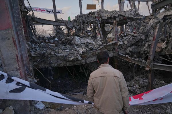
Jon Russell, a volunteer fire brigade captain from the northern beaches, has spent the night out at the Gospers Mountain fire where backburning operations near Mt Tomah went out of control and took out up to 20 properties.
“We’d been told properties had come under attack, that this fire had just gathered momentum,” he said.
“The Hills district [brigades] were there, from the Cumberland zone, they were there from everywhere... it was a case of just ‘pick a house and protect it’.”
He described lining up his truck in front of a house, remarking to a colleague John Duffy (who filmed that incredible footage above), that if a nearby area of bush caught alight there’d be little they could do, and they’d have to leave.
“Then in an instant that area of bush just went boom.”
“We just went from daylight to nighttime in a instant. It’s a very eerie feeling for new people. I’ve been at this a long time, I’ve been captain of my brigade 18 years. It was an experience for everybody that we’ll never forget.”
Updated
Australia is facing a massive rethink on how it prepares for long-term bushfires and air pollution, my colleague Melissa Davey reports.
David Bowman, the director of the Fire Centre at the University of Tasmania’s school of natural sciences, says it’s too late to call for action to prevent climate change and that people affected by smoke inhalation from fires should demand moves to adapt to it, such as retrofitting houses to make them heat and smoke-proof.
“It’s a transformative time socially, and politicians have completely misunderstood this,” Bowman said. “Politicians talk about holding the line, but this is escalating.
“Hobart was fumigated at the beginning of this calendar year for six weeks because of fires. The cost of that was six deaths and $25m in health costs.”
Updated
In South Australia, AAP reports that extra payments will be made to people affected by out-of-control bushfires last month.
Hardship payments of up to $10,000 – jointly funded by the state and federal governments – will be available to property owners who were affected on the Yorke Peninsula.
Two fires at Price and Yorketown last month caused considerable damage, with at least 11 homes impacted, and damage was also caused to crops, livestock and other infrastructure.
The largest fire burned through more than 5,000 hectares after being sparked by a power network fault.
Federal natural disaster minister David Littleproud said: “This puts cash in the pockets of those most in need and helps to give them dignity. It will also help to cover any insurance shortfalls to make sure these communities can be restored.”
Updated
A map of that Mount Tomah, Mount Irvine, Mount Wilson fire.
Here's the fire near Mount Tomah in the Blue Mountains that was confirmed to have been started by backburning.
— Naaman Zhou (@naamanzhou) December 16, 2019
Note how it's currently separate from the huge Gospers Mountain fire - but could join up. Up to 20 homes destroyedhttps://t.co/wQ6pGS5cKO pic.twitter.com/KChYpRKPuZ
Up to 20 properties destroyed in fire started by backburning
A few developments here. The ABC has confirmed that up to 20 properties have been destroyed near Mount Irvine, Mount Wilson and Mount Tomah.
RFS commissioner Shane Fitzsimmons also confirmed to the ABC that the fire itself was started by a backburning operation.
#BREAKING: NSW RFS Commissioner Shane Fitzsimmons has confirmed a fire which destroyed up to 20 structures in the Blue Mountains was started by a backburning operation.
— Gavin Coote (@GavinCoote) December 16, 2019
According to anchor Joe O’Brien, Fitzsimmons said firefighters were “attempting to protect communities around the Bells Line of Road but unfortunately things don’t always go to plan”.
Earlier, deputy commissioner Rob Rogers said in an interview: “We were quite concerned about that fire jumping Bells Line Of Road. Crews backburned to try to prevent. The backburn got away as well. Nothing is working out for crews.
“Unfortunately in these drought conditions, that’s the reality – whatever we try doesn’t seem to be working and, you know, we just got to try to protect as many properties as we can.”
Updated
Dozens of homes damaged
RFS commissioner Shane Fitzsimmons has confirmed that dozens of homes have been damaged. He told Nine’s Today Show it was even possible that the local RFS captain lost their home.
“We have reports of dozens of building, structures having been damaged or destroyed,” he said. “We are just not sure on homes and outbuildings and sheds and those sorts of things. I am hearing reports that even our local members and it might be our local captain have lost their home last night trying to defend their local community.”
With the heatwave this week making things worse, he said there was an “extraordinary amount of work still to go”.
“The drought is having an absolutely profound effect on the vegetation, and its flammability,” he said. “We are seeing fire burn effectively unimpeded under windy conditions.”
Updated
The latest advice on the Gospers Mountain fire from the RFS.
“The fire continues to burn on both sides of the Bells Line of Road, and is now burning in the Gross Valley ... Monitor conditions and know what you will do if fire threatens.”
The huge fire is also burning near Bell, Newnes Junction, Clarence, Colo, the lower and upper Macdonald, Perrys Crossing and Wollomi national park.
Watch and Act: Gospers Mountain
— NSW RFS (@NSWRFS) December 16, 2019
The fire is active on both sides of the Bells Line of Road & is now burning in the Grose Valley. If you're in the areas of Mt Lagoon, Bilpin, Mt Irvine, Mt Wilson, Berambing & Mt Tomah, monitor conditions. https://t.co/ekOSH2RQ4v #nswrfs #nswfires pic.twitter.com/tq3bj96scv
Updated
According to Sky News, dozens of homes are feared lost near Mount Tomah, as a result of the Gospers Mountain fire.
But assessment teams will only be sent once the area is deemed safe, which is not expected until later today at least.
In SA, it is already 35C in Ceduna and over 38C at Moomba Airport. It’s 29C in the Adelaide city centre.
The forecast for Queensland is also sweltering. It’s set to hit 44C for Mount Isa, 44C for Birdsville. 41C in Gympie and Rockhampton, 39C in Brisbane, and 34C in Townsville.
Hey #Queensland, today is set to be a scorcher! Follow @qldhealthnews advice on how to beat the heat - look after yourself and others (incl. furry and feathered friends), do what you can to keep cool and stay hydrated. pic.twitter.com/Bmg8Avh0sq
— Bureau of Meteorology, Queensland (@BOM_Qld) December 15, 2019
And it’s already 38C in Mount Isa, and 32.7C in Brisbane.
It’s only 7.30am in WA, but it’s already 31C in Broome – and rising.
According to 7.10am observations from the Bureau of Meteorology, it is 30C in Marble Bar, 27C in Kalgoorlie and 27.5C in Perth.
That is forecast to rise to 43C in the Kimberley, 40C in Kalgoorlie and 36C in Perth during the day.
Twenty-two health groups – including the Australasian College of Emergency Medicine, Public Health Association of Australia and Lung Foundation Australia – have labelled the bushfire smoke a “public health emergency”.
They have called on Scott Morrison and Gladys Berejiklian to act, saying “governments have a responsibility to protect the people they represent”.
“There is no safe level of air pollution,” the joint statement says.
In August, the Australian Medical Association declared that climate change was a “health emergency”, because of the “clear evidence” showing it would create health risks for people now and in the future.
Updated
This is fire that came at Sam Ramaci’s property yesterday. Southern flank of the Gospers Mountain blaze. @abcnews @abcsydney pic.twitter.com/zQE9KIzoCv
— Jonathan Hair (@JonathanHair) December 15, 2019
More homes lost in Bilpin in the Blue Mountains.
BILPIN: Sam Ramaci is famous in these parts for his apple pies... but overnight the unstoppable #GospersMountain fire destroyed his cool room with 5 mths worth of food for his cafe inside. He also lost his former family home that was filled with memories of his 3 kids growing up pic.twitter.com/9ih64L7bi1
— Kimberley Pratt (@Kim_Pratt10) December 15, 2019
And in WA today, the fire danger is extreme for Gascoyne Inland, Eucla and Avon.
It is severe for Ashburton inland, inland central west – south, lower west inland, upper great southern, Roe, Mortlock and Ninghan.
Updated
New South Wales:
With High to Severe fire danger across NSW and five areas under a Total Fire Ban today, it's important that you know your fire risk and what you and your family will do if fire threatens. Report any new unattended fires to Triple Zero (000). #NSWRFS pic.twitter.com/ZH4Ho8C6Er
— NSW RFS (@NSWRFS) December 15, 2019
Some of the fire danger ratings for today.
Queensland:
Parts of Qld will experience extreme & severe fire conditions today. Please:
— Qld Fire & Emergency (@QldFES) December 15, 2019
📱Stay up-to-date with warnings
🚨Have a bushfire survival plan
🚒Follow the advice of QFES & other authorities
📞Report bushfires to Triple Zero (000)
🙅Avoiding activities that could start a fire pic.twitter.com/0YVTiwb6BN
The Mt Tomah Botanical Gardens are currently closed for a few days, according to a statement, but there is no news on whether they have been directly affected.
The Garden will remain closed over the coming days due to ongoing bushfires in the area. We will provide further updates on the reopening of the Garden as they come to hand. Further info: https://t.co/mrRtsoRteh
— BlueMtnsBG (@BlueMountainsBG) December 15, 2019
“We at the garden are extremely grateful to the emergency service personnel and volunteers who are dedicating their time and efforts to dealing with the devastating bushfires,” management said.
“We will provide further updates on the reopening of the Garden on our social media channels.”
Updated
There are also fears for the Mt Tomah Botanical Gardens, which lie within the fire area.
I really hope the @NSWRFS Fires Near Me map isn't right about this. @BlueMountainsBG at Mt Tomah is one of my favourite places, full of beautiful birds and plants. Losing it to fire would be heart-breaking :( pic.twitter.com/SMEgRIpA1n
— David C. Simon (@davidcsimon) December 15, 2019
And homes have already been destroyed, according to photographer Nick Moir, from the Sydney Morning Herald.
The damage done by the Gospers Mountain fire will be on the minds of residents today. On Sunday, the huge blaze was upgraded to emergency, as it jumped containment lines near Bowen Creek.
There are early reports that properties have been destroyed, near Mount Tomah and Mount Wilson. So far the fire has burned through 380,000 hectares. The firegrounds stretch from Lithgow, through the Hawkesbury and towards the central coast.
This morning, the Rural Fire Service said fire activity had “reduced” around the Gospers Mountain blaze, and “there is currently no immediate threat”. But it is expected to worsen as temperatures rise this week.
Updated
Good morning and welcome to our live coverage of the bushfire crisis and this week’s hot weather.
Across the country, a severe to extreme heatwave is settling in. Currently, it’s sitting over southern Western Australia and most of South Australia, Queensland and the Northern Territory – from Broome to Brisbane. In coming days, it will sweep east and south, blanketing most of NSW and the ACT.
Over the weekend, the huge Gospers Mountain fire in NSW flared to emergency levels. It is currently at watch and act, but remains a threat to homes. The extent of the damage will become more apparent today.
In WA, an emergency warning is still active for a fire near Wilbinga, Woodridge, Seatrees and Breakwater Estates, north of Perth.
Across the country, it’s forecast to hit 43C in WA’s Kimberley region, 40C in Kalgoorlie, 36C in Perth; 44C in Mount Isa in Queensland, 41C in Rockhampton , 39C in Brisbane; 43C in Oodnadatta in SA, 34C in Adelaide, and 41C in Walgett and Bourke in NSW.
Updated