A car navigation system launched in Ishinomaki, Miyagi Prefecture, offers a narrated guide to the area, serving as a virtual storyteller about the local places affected by the 2011 Great East Japan Earthquake and tsunami.
The system is loaded on some rental cars in Ishinomaki, where about 3,700 people died or remain missing after the disaster.
Expectations are high that the service, Kataribe Navi (Storytelling navigation), will help prevent the fading of memories of the disaster as the 10th anniversary of the tragedy approaches in March next year.
The activities of actual kataribe storytellers who have passed on the stories of the disaster have been limited because of the novel coronavirus pandemic, so the system allows people to learn about the disaster while avoiding infection risks.
The Ishinomaki-based Japan Car Sharing Association introduced Kataribe Navi after fielding queries from users who said they did not know where the relics of the quake were or how to get to those places. The association was formed in October 2011 to loan cars to residents in disaster-stricken areas and to some support groups for free for a certain period.
The association had been searching for a way to help hand down the experiences of the disaster. It commissioned car navigation system manufacturer Aisin AW Co. of Anjo, Aichi Prefecture, to create the system. Aisin AW, which already makes navigation systems that come with functions to guide tourists, incorporated the stories told by Ishinomaki's kataribe storytellers to make Kataribe Navi.
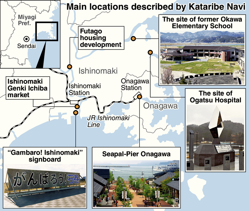
The Kataribe Navi system has four navigation routes, guiding users to disaster-stricken locations in courses that take between two hours to an entire day. All four courses start at the association's office near JR Ishinomaki Station and begin with a voice saying, "Unfortunately, Ishinomaki is the area most affected by the earthquake and tsunami."
When the vehicle arrives at the former Okawa Elementary School where 84 children, teachers and staff died or remain missing, Kataribe Navi says, "They had 51 minutes before a tsunami of up to 8.6 meters high hit the school, but it was only one minute before the arrival of the tsunami that they started to evacuate."
Driving to the Futago housing development, which used to be a rice paddy but is now dotted with houses to accommodate the mass relocation of disaster victims, visitors can confirm the state of reconstruction. The navigator describes how about 320 households moved there after becoming unable to live in their hometowns.
Among other locations of heavily damaged buildings and reconstructed areas described by the system are the site of the municipal Ogatsu Hospital, where patients were among the more than 60 people who died, and Seapal-Pier Onagawa, a shopping district in the town of Onagawa.
A 60-year-old company employee transferred from Kobe to Ishinomaki in January, used the navigation system on Nov. 3 because he hadn't had the chance to attend a storytelling session about the disaster.
"There were so many things I didn't know about," he said after spending six hours driving around Ishinomaki and Onagawa. "The fact that most children at the Okawa Elementary School died struck me hard. It made me wonder why they couldn't escape."
Storytelling activities continue to be canceled or postponed. Up to 45,000 people would have come for the events and activities run by 24 disaster-related storytelling groups, which have been canceled since spring, according to the 3.11 Memorial Network, an organization based in Miyagi Prefecture that also draws members from Iwate and Fukushima prefectures, the other places hit hard by the disaster.
"We would like people to use the navigation system to start learning about the disaster," an official of the Japan Car Sharing Association said.
Read more from The Japan News at https://japannews.yomiuri.co.jp/