A new ocean expedition in the South Pacific has revealed striking new images of more than a dozen ships sunk during key World War II battles.
Researchers on the Ocean Exploration Trust vessel Nautilus conducted an archaeological survey of 13 shipwrecks from the Solomon Islands campaign, one of the war’s fiercest naval confrontations.
Using advanced remotely operated vehicles equipped with high-definition cameras and submersible drones, they also rediscovered two long-lost vessels, the USS New Orleans and the Imperial Japanese Navy destroyer Teruzuki.
While some of the wrecks were first located over 30 years ago, the latest expedition allowed for a far more detailed and comprehensive survey, thanks to cutting-edge imaging technology, researchers said.
“This expedition was special, allowing us to film these sites in a manner not possible back then, as well as document other ships, while at the same time sharing our work live to the entire world,” Ocean Exploration Trust president Robert Ballard said in a statement.
The wreck site, known as Iron Bottom Sound, lies in the Solomon Islands between Guadalcanal, Savo, and Nggela islands.
Between August and December 1942, Iron Bottom Sound was the site of five major naval battles during the Second World War, resulting in the loss of more than 20,000 lives, 111 naval vessels, and 1,450 aircraft.
Dozens of shipwrecks lie on the seafloor at this site, just off the coast of Honiara, within a relatively compact area measuring less than 25 nautical miles wide, 40 nautical miles long, and up to 1,400 metres deep.
But fewer than 100 of these American, Japanese, Australian, and New Zealand military ships and planes have been located to date.
“This survey of the ships of the United States, Australia, and Japan will add immeasurably to the understanding of one of the costliest naval campaigns in history, a campaign that hopefully will never be repeated,” said Samuel J Cox, Naval History and Heritage Command director.
In the latest survey, researchers mapped more than 386 square miles of seafloor using the uncrewed surface vehicle DriX, operated by the University of New Hampshire.
The crew spent nearly 140 hours exploring various wrecks using ROVs, some located more than 3,280 feet beneath the ocean’s surface.
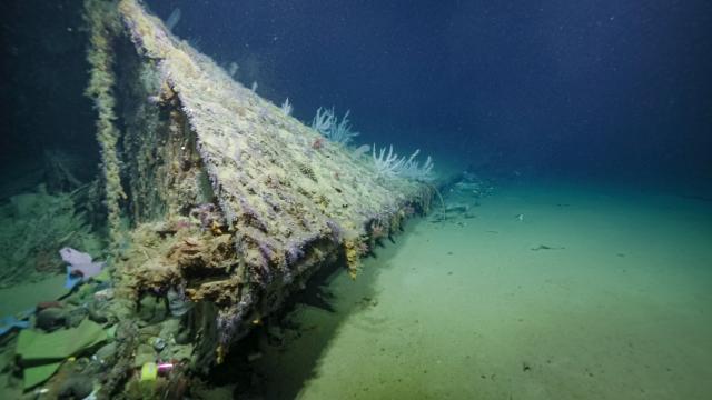
For the first time, researchers took pictures of the bow that was blown off the World War II heavy cruiser USS New Orleans.
The USS New Orleans was struck by a Japanese “Long Lance” torpedo during the November 1942 Battle of Tassafaronga, off the coast of Guadalcanal. The powerful explosion sheared off nearly a third of the ship, including its entire bow, and claimed the lives of more than 180 crew members.
“The use of our uncrewed vessel allowed a tremendous increase in exploration efficiency as we were able to continuously map and identify potential targets while the Nautilus was deploying its ROVs,” said Larry Mayer, director of the Center for Coastal and Ocean Mapping at the University of New Hampshire.
“This technological achievement, combined with the tremendous historical significance of our discoveries, made this one of the most rewarding missions I have ever participated in.”
Discovery in Arctic cave provides a ‘rare snapshot of a vanished world’
Ancient tombs and 1,000-year-old remains uncovered during gas works
What medieval skeletons tell us about long-term health and life expectancy
Toddler bone remains may be earliest evidence of cannibalism in Europe
Mystery 4,000-year-old handprint found on Egyptian soul house
Mystery petroglyphs dating back at least 500 years reappear on public beach