It’s a rough start to the day for almost 30,000 homes across New South Wales, with wild weather knocking out power and forcing urgent evacuation orders up and down the coast. As a “bomb cyclone” lashes the state, emergency services and energy crews are scrambling to keep up, and the advice for many is simple: stay home, stay safe, and keep across updates.
The Bureau of Meteorology has warned that the system is only getting stronger, with winds up to 125km/h and relentless rain making things worse by the hour. Sydney’s eastern suburbs, the Illawarra, and the South Coast are all facing the brunt, and the BoM says the worst may not hit until later today and tomorrow.

The power situation is especially grim. Ausgrid confirmed that 10,500 customers in Sydney’s north, the Central Coast and Newcastle had their lights go out overnight, mostly thanks to trees and powerlines coming down in the wind. “At 6am, there are 6,500 customers out in the Hunter/Newcastle region, 3,000 in the Central Coast and just under 1,000 in Sydney,” Ausgrid said in a statement.
The company also warned that “as the wild weather continues into the morning, there could be more outages throughout the day – as well as flooding and hidden hazards, particularly around fallen or damaged trees”.
Endeavour Energy reported nearly 17,000 customers without power in the Blue Mountains, Western Sydney, Illawarra and parts of regional NSW, and Essential Energy said over 2,000 homes were also affected.
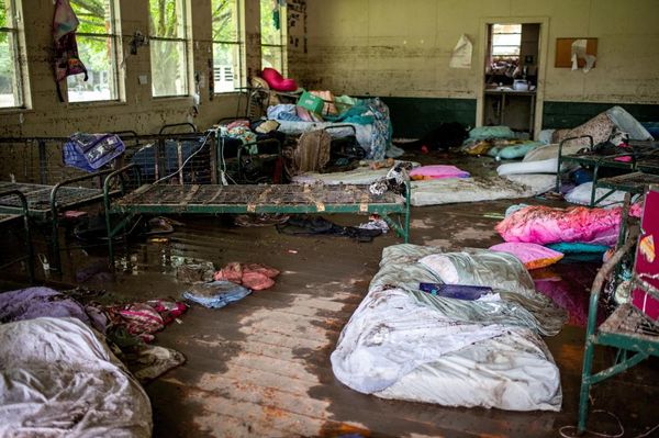
The SES has been flat out responding to more than 900 incidents since the storm started, including floodwater rescues and calls for help with fallen trees and damaged homes.

Several regions are now under emergency warnings, with people in low-lying areas around Burril Lake told to shelter in place as water levels rise. Residents at North Entrance and Wamberal have been ordered to evacuate because of severe coastal erosion, and in Sanctuary Point near Jervis Bay, the SES is urging people to move to higher ground after flooding made it unsafe to leave later on.
BoM senior meteorologist Jonathan How warned that the rain is not letting up, and there’s a real risk of flash flooding, especially south of Wollongong. Some places could see up to 120mm of rain in just six hours.
“With winds set to intensify and heavy rain continuing and the addition of coastal hazards, we could see some dangerous conditions out there over the next few days,” How said, per Yahoo News.
Transport is a mess, too. Ferry, bus and train services are delayed or cancelled, and roads are underwater in places like Byron Bay, Jervis Bay, and even parts of Sydney.
Sydney Trains Chief Executive Matt Longland told ABC Radio Sydney that “we’ve seen some really significant damages”, and warned that repairs to overhead power lines and tracks may take days.
“I encourage everyone to please stay safe and avoid any unnecessary travel — there will be delays across the network … we’ll keep providing as much information as we can,” he said.
Authorities are urging everyone in affected areas to stay put if they can, keep an eye on SES and BoM updates, and avoid flooded roads at all costs.
SES Acting Assistant Commissioner Allison Flaxman said, “These incidents are a timely reminder that roads are slippery, and conditions can become dangerous quickly. Please never drive, walk or play in floodwaters. If you do come across a flooded road, turn around and find an alternative route.”
With another low-pressure system expected to hit later today and conditions not set to ease until late Thursday, it’s shaping up to be a long couple of days for NSW.
Lead image: 9News / NSW SES
The post Nearly 30,000 Homes Lose Power As Evacuations Ordered Across NSW In Bomb Cyclone Chaos appeared first on PEDESTRIAN.TV .