The National Hurricane Center is set to update its 'cone of uncertainty' forecast tool this year to include predictions for inland areas, where wind and flooding can be more treacherous than damage along the coast. The experimental graphic will be ready by August 15, just in time for the peak of the hurricane season.
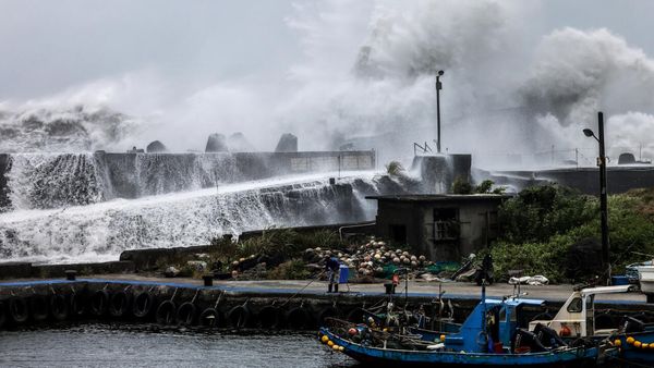
The traditional cone, which has been used for years, focuses primarily on the forecast track of a hurricane or tropical storm, with an emphasis on wind and storm surge along the coasts. However, forecasters have always cautioned against solely relying on the center line. Inland areas can experience heavy rains and strong winds that can be deadly and cause significant damage. The devastating Hurricane Ian in 2022 claimed 149 lives in Florida, highlighting the importance of considering these inland threats.
The expanded forecast cone aims to ensure that people living away from the coast are aware of the dangers they could still face. The new cone incorporates colors to indicate the areas at risk in a much broader and clearer way. If someone resides within those colored areas, they are under risk, according to Jamie Rhome, the deputy director of the hurricane center.
Experts have been observing mounting evidence that the impacts of climate change, including rising sea levels, are intensifying the most severe hurricanes and increasing the likelihood of rapid intensification. This leads to more significant flooding and more powerful storm surges along coastlines.
In the case of Hurricane Ian, after it passed through the Fort Myers area, the storm continued to bring heavy rains and topple trees across a wide stretch of Florida. The aftermath included floods reported around Orlando and its neighboring areas, reaching east to Daytona Beach and south to Kissimmee. Even central Florida's agricultural region experienced flooding, impacting the local cattle and citrus industries. The hurricane center reported that Ian brought between 10 and 20 inches (51 centimeters) of rain across much of central Florida.
Furthermore, the impact on rivers in inland areas was particularly severe and possibly unexpected. In DeSoto County, after Ian traversed the region, the Peace River flooded the community, prompting Fire Chief Chad Jorgensen to urgently advise residents to evacuate. He emphasized the unpredictability and dangers associated with the rising river levels.
Looking ahead, the first named storm of the upcoming hurricane season will be Alberto. The previous year, 2023, saw a total of 20 named storms, including seven hurricanes. Hurricane Idalia was the only one that made landfall in the United States, striking the lightly-populated Big Bend region of Florida's Gulf Coast but still causing significant inland flooding.
With the updated cone of uncertainty, the National Hurricane Center aims to provide enhanced forecasts that encompass the risks faced by both coastal and inland residents. By offering a clearer understanding of potential wind hazards and flooding dangers, the center hopes to better equip individuals to prepare and protect themselves during the hurricane season. As the impacts of climate change continue to manifest, it becomes increasingly vital to stay informed and take proactive measures to mitigate the effects of these powerful storms.