Satellites are keeping a close eye on a phenomenon brewing in the Pacific Ocean.
The waters near South America’s west coast are getting warmer. Satellites like Sentinel-6 Michael Freilich, a collaboration between Europe and the U.S., know this because the sea level there has amplified; warm stuff expands, and cold stuff contracts. Rising surface ocean temperatures in the central-eastern Pacific then have a cascading effect on weather patterns in Asia and North America. It’s called El Niño.
“This year’s El Niño is still developing, but researchers are looking to the recent past for clues as to how it is shaping up,” officials from NASA’s Jet Propulsion Laboratory (JPL) in Pasadena, California, write in a statement published Wednesday. JPL’s home state received heavy rain during the 2015-2016 El Niño, which caused high surf, massive flooding, and dangerous mudslides.
What can we expect during this El Niño?
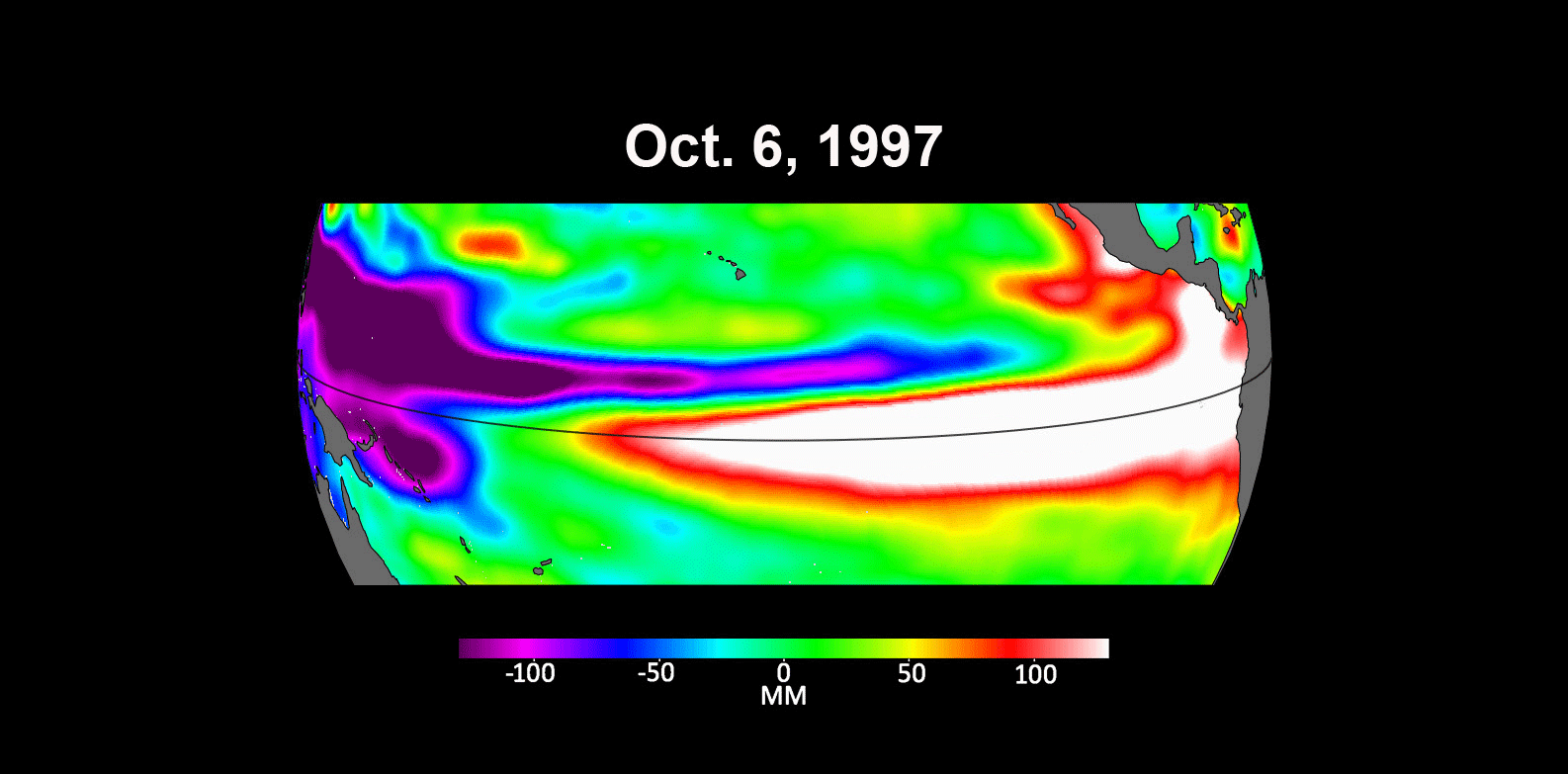
A new NASA image compares the start of the 2023 El Niño to those churning away in October 1997 and October 2015. Those years were considered extreme events, according to NASA. “Both caused shifts in global air and ocean temperatures, atmospheric wind and rainfall patterns, and sea level,” according to the space agency.
In the image, higher-than-average sea level height is colored red and white. Lower-than-average height appears in blue and purple.
Rising surface water temperatures weaken the surface winds that blow east to west. According to the National Oceanic and Atmospheric Administration (NOAA), both result in an increase of rainfall over the eastern and central Pacific and simultaneously cause a decrease in rainfall over Indonesia. The atmospheric activity over the Pacific Ocean also shifts the jet stream. This gives rise to wetter and colder conditions in the southern U.S., plus drier and warmer conditions in the north.
For now, this year’s system looks tame.
“Every El Niño is a little bit different,” Josh Willis, Sentinel-6 Michael Freilich project scientist at JPL, shares in the statement. “This one seems modest compared to the big events, but it could still give us a wet winter here in the Southwest U.S. if conditions are right.”
Monitoring the Pacific Ocean
The Sentinel-6 Michael Freilich satellite belongs to the Copernicus Sentinel-6/Jason-CS (Continuity of Service) mission, which was jointly developed by the European Space Agency, the European Organisation for the Exploitation of Meteorological Satellites (EUMETSAT), NASA, and NOAA.
It’s named after Michael Freilich, former director of NASA’s Earth Science Division.