A stone with mysterious markings dating back 4,000 years is being used as a “treasure map” by archaeologists hunting for ancient sites around northwest France.
The so-called Saint-Belec Bronze Age slab was first discovered in Brittany in 1900 and then found again in the cellar of a French castle in 2014.
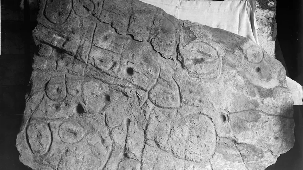
In 2021 researchers said the slab, 5ft by 6.5ft in size, was the oldest 3D map of a known area in Europe. Now they are using it in a bid to find more archaeological sites.
"Using the map to try to find archaeological sites is a great approach. We never work like that,” said Yvan Pailler, a professor at the University of Western Brittany (UBO), who called it a “treasure map”.
The map marks an area roughly 30 by 21km and Pailler’s colleague, Clement Nicolas from the CNRS research institute, said they would need to survey the entire territory and cross reference the markings on the slab - a job he said could take 15 years.
The pair were part of the team who found the slab in 2014.
It was first discovered during digs on a prehistoric burial ground in Finistère, western Brittany, by local archaeologist Paul du Chatellier.
More than a dozen workers were needed to move the heavy slab out of the mound, where it had been used to form a wall of a large burial chest, according to France’s National Archeology Museum. It has been kept in the museum’s collections since 1924.
The piece of rock is believed to date from the early Bronze Age, between 1900 BC and 1650 BC and its “repeated motifs joined by lines” give the layout of a map, researchers say.
A previous study in the Bulletin of the French Prehistoric Society said the markings on the map represented the River Odet valley, with several lines appearing to depict the area’s river network.
French experts were joined by colleagues from other institutions in the countries and overseas as they continue trying to make sense of the map.
Researchers are working to decode the map— (University of Western Brittany)
"There were a few engraved symbols that made sense right away," said Pailler.
Pailler said some of the coarse bumps and lines on the slab, resembled the mountains and rivers of Roudouallec, part of the Brittany region about 500 km west of Paris.
The researchers scanned the slab and compared it with current maps, finding a roughly 80 per cent match. It also has tiny hollows which the experts think could point to burial mounds, dwellings or geological deposits.
If these can actually be deciphered then it could lead to a load more discoveries beyond what has already been found, they added.
"We still have to identify all the geometric symbols, the legend that goes with them," said Nicolas.
The archaeologists are also carrying out excavations at the spot where the slab was uncovered more than a century ago in a bid to “better contextualise the discovery, to have a way to date the slab”.
Their efforts have already turned up some previously undiscovered fragments from the slab, which had been broken off and repurposed as a tomb wall.
Nicolas said the discovery hinted at a once-thriving ancient kingdom that collapsed in a series of revolts and rebellions thousands of years ago, leading to the engraved rock being broken.